

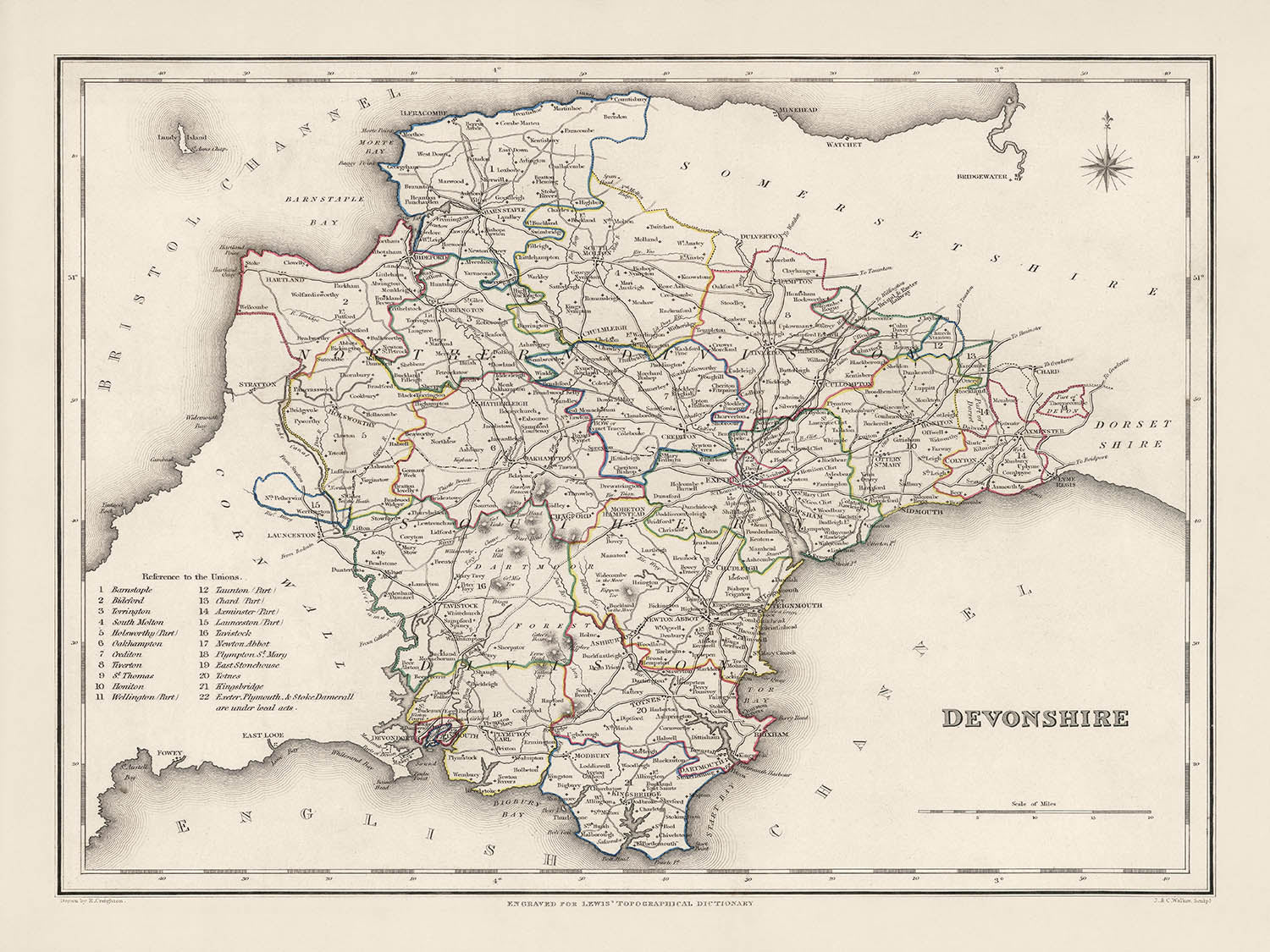


Mappa antica del Devon di Samuel Lewis, 1844: Exeter, Plymouth, Torquay, Paignton e Barnstaple
20% di sconto su 2 — 33% di sconto su 3
Aggiungi qualsiasi due articoli idonei al tuo carrello per ricevere 20% di sconto. Aggiungi un terzo e sarà gratuito (equivalente a 33% di sconto quando acquisti tre).
Nessun codice necessario — l'offerta si applica automaticamente al checkout.
Valido su tutte le mappe standard e le stampe d'arte fine. Puoi mescolare e abbinare qualsiasi design.
Se desideri spedire articoli a più indirizzi, ti preghiamo di contattarci prima di effettuare il tuo ordine.
Le commissioni personalizzate e su misura sono escluse.
Contattaci se hai domande

Restaurata dalla mappa originale del 1844 e stampata in qualità museale. Leggi la storia dietro questa mappa
Choose your size
Choose your finish


(Maggiori informazioni)
Gift message & custom finish

If you want to add a gift message, or a finish (jigsaw, aluminium board, etc.) that is not available here, please request it in the "order note" when you check out.
Every order is custom made, so if you need the size adjusted slightly, or printed on an unusual material, just let us know. We've done thousands of custom orders over the years, so there's (almost) nothing we can't manage.
You can also contact us before you order, if you prefer!

- Prodotto localmente. Consegna sicura
- Nessun dazio o costo nascosto
- Serve aiuto? Chiamaci o messaggio su WhatsApp
Own a piece of history
8,000+ five-star reviews


Vivi un viaggio nel passato con questa squisita mappa del 1844 del Devonshire, realizzata dal rinomato cartografo Samuel Lewis. Questo straordinario reperto...
Continua a leggereVivi un viaggio nel passato con questa squisita mappa del 1844 del Devonshire, realizzata dal rinomato cartografo Samuel Lewis. Questo straordinario reperto dell'era vittoriana è intriso della ricca storia della contea, rivelando i suoi insediamenti, le caratteristiche geografiche e gli eventi storici. Dalle vivaci città di Exeter e Plymouth ai pittoreschi paesi lungo il fiume Dart, la mappa dipinge un vivido quadro del paesaggio del Devon quasi due secoli fa. Un tesoro per gli appassionati di storia, gli entusiasti della cartografia e i Devoniani, offre uno sguardo affascinante su un'epoca in cui le moderne città della contea erano ancora in fase di sviluppo o dovevano ancora essere fondate, e alcuni luoghi potrebbero esistere sotto i loro nomi precedenti.
Ciò che rende questa mappa veramente straordinaria non è solo la profondità e il dettaglio con cui rappresenta il Devonshire, ma anche il suo significato storico. Risalente alla metà del XIX secolo, questo documento autentico offre uno spaccato degli insediamenti e dei punti di riferimento geografici del Devon come esistevano prima dell'espansione urbana significativa e dello sviluppo industriale. In un'epoca prima delle immagini satellitari e della tecnologia GPS, la mappa di Lewis è un'impresa impressionante di cartografia che cattura fedelmente i dettagli geografici intricati del Devon e la sua vasta gamma di insediamenti.
Insediamenti inclusi in questa mappa, ordinati per dimensione della popolazione moderna:
- Exeter (fondata come forte romano nel 55 d.C.) - Conosciuta per la sua straordinaria cattedrale e la sua ricca storia.
- Plymouth (fondata nel 1254) - Città storica di marinai e punto di partenza del Mayflower.
- Torquay (fondata nel 1196) - Famosa per la sua straordinaria costa, conosciuta come la Riviera inglese.
- Paignton (i documenti risalgono al 1086) - Una città balneare nota per il suo zoo e la sua spiaggia.
- Barnstaple (fondata nel 930) - Il borough più antico del Regno Unito.
- Newton Abbot (i documenti risalgono al 1246) - Conosciuta per la sua fiera annuale di formaggio e cipolle.
- Tiverton (fondata nel VII secolo) - Nota per il suo storico commercio della lana.
- Bideford (fondata nel 1272) - Città portuale storica.
- Exmouth (riferimenti precoci nel XII secolo) - Conosciuta per il suo lungomare e il suo porto turistico.
- Sidmouth (fondata prima del 1086) - Una città famosa per la sua architettura Regency.
- Ilfracombe (menzionata nei documenti nel 1086) - Una località balneare e un porto.
- Teignmouth (fondata prima del 1044) - Conosciuta per il suo porto storico.
- Tavistock (concessa nel 1105) - Il luogo di nascita di Sir Francis Drake.
- Dawlish (riferita nel Domesday Book del 1086) - Una tradizionale località balneare.
- Crediton (fondata prima del 909) - La sede storica dei primi Vescovi del Devon.
- Cullompton (insediamento preistorico, città stabilita nel IX secolo) - Nota per il suo mercato storico.
- Totnes (fondata prima del 907) - Conosciuta per il suo castello normanno.
- Brixham (menzionata nel Domesday Book del 1086) - Una città di pescatori con una ricca storia marittima.
- Honiton (fondata in epoca pre-romana) - Rinomata per la sua produzione di pizzi.
- Kingsbridge (registrata per la prima volta nel 962) - Situata nell'Area di Eccezionale Bellezza Naturale del Sud Devon.
- Ivybridge (riferita in documenti dal 1280) - Conosciuta per le sue cartiere e il bellissimo Ivy Bridge.
- Great Torrington (concessa nel 1340) - Nota per i suoi legami storici con la Guerra Civile inglese.
- Dartmouth (fondata prima del XII secolo) - Conosciuta per il Castello di Dartmouth e il suo pittoresco porto.
- Ashburton (registrata per la prima volta nel 1086) - Antica città stannaria situata all'interno del Parco Nazionale di Dartmoor.
- Buckfastleigh (citato nel Domesday Book del 1086) - Nota per la sua storica industria della lana.
- Chudleigh (concesso nel 1309) - Famosa per il Grande Incendio di Chudleigh nel 1807.
- Salcombe (registrato nel 1244) - Conosciuto per i suoi sport acquatici e come un rifugio per yatch.
- Beer (fondato prima dei Romani) - Nota per le sue scogliere pittoresche e le Cave della Cava.
- Ottery St Mary (citato nel Domesday Book del 1086) - Conosciuto per la sua tradizione dei 'Barili di Catrame'.
- Budleigh Salterton (citato nel Domesday Book del 1086) - Un affascinante paese costiero noto per la sua spiaggia di ciottoli.
Confini, fiumi, gole, parchi nazionali e fenomeni naturali notevoli nel Devonshire:
- Parchi Nazionali di Dartmoor: Conosciuto per le sue brughiere, le cime granitiche e i siti preistorici.
- Parchi Nazionali di Exmoor: Famoso per la sua costa accidentata e le brughiere di erica.
- La Jurassic Coast: Un Sito Patrimonio dell'Umanità noto per le sue scogliere e i siti fossili.
- Fiume Exe: Un fiume principale che scorre attraverso il cuore del Devon.
- Fiume Dart: Conosciuto per la sua bellezza scenica e Dartmouth, la sua città estuariale.
Eventi storici tra il 1800 e il 1850:
- L'apertura del storico Cantiere Navale di Plymouth nel 1824, un importante catalizzatore per la crescita della città.
- La costruzione del Tamar Bridge che collega il Devon alla Cornovaglia nel 1859.
- L'arrivo della ferrovia nel Devon nel 1844, che ha notevolmente migliorato la comunicazione e il commercio.
Quindi, sia che tu sia un appassionato di storia o un amante del Devon, questa mappa offre un'esplorazione emozionante e approfondita nel passato di questa straordinaria contea.
Ti preghiamo di controllare le immagini per assicurarti che una specifica città o luogo sia mostrato su questa mappa. Puoi anche contattarci e chiedere di controllare la mappa per te.
Questa mappa appare fantastica in tutte le dimensioni: 8x10in (20.5x25.5cm), 12x16in (30.5x41cm), 18x24in (45.5x61cm), 16x20in (40.5x51cm), 24x36in (61x91.5cm), 30x40in (76x101.5cm) e 37x50in (94x127cm), ma appare ancora meglio quando stampata in grande.
Posso creare stampe belle e grandi di questa mappa fino a 50in (127cm). Ti preghiamo di contattarci se stai cercando opzioni di incorniciatura più grandi, personalizzate o diverse.
Il modello nelle immagini dell'inserzione sta tenendo la versione 18x24in (45.5x61cm) di questa mappa.
La quinta immagine dell'inserzione mostra un esempio del mio servizio di personalizzazione della mappa.
Se stai cercando qualcosa di leggermente diverso, dai un'occhiata alla mia principale collezione di mappe del Regno Unito e dell'Irlanda.
Ti preghiamo di contattarmi per controllare se una certa località, monumento o caratteristica è mostrata su questa mappa.
Questa sarebbe una meravigliosa idea regalo per un compleanno, Natale, Festa del Papà, un addio al lavoro, un anniversario o una festa di inaugurazione per qualcuno delle aree coperte da questa mappa.
Questa mappa è disponibile come stampa giclée su carta opaca archivistica priva di acidi, oppure puoi acquistarla incorniciata. La cornice è una semplice cornice nera che si adatta alla maggior parte delle estetiche. Ti preghiamo di contattarci se desideri un colore o un materiale di cornice diverso. Le mie cornici sono dotate di un'acrilico museo super chiaro (perspex/acrylite), che è significativamente meno riflettente del vetro, più sicuro e arriverà sempre in perfette condizioni.
This map is also available as a float framed canvas, sometimes known as a shadow gap framed canvas or canvas floater. The map is printed on artist's cotton canvas and then stretched over a handmade box frame. We then "float" the canvas inside a wooden frame, which is available in a range of colours (black, dark brown, oak, antique gold and white). This is a wonderful way to present a map without glazing in front. See some examples of float framed canvas maps and explore the differences between my different finishes.
For something truly unique, this map is also available in "Unique 3D", our trademarked process that dramatically transforms the map so that it has a wonderful sense of depth. We combine the original map with detailed topography and elevation data, so that mountains and the terrain really "pop". For more info and examples of 3D maps, check my Unique 3D page.
Vivi un viaggio nel passato con questa squisita mappa del 1844 del Devonshire, realizzata dal rinomato cartografo Samuel Lewis. Questo straordinario reperto dell'era vittoriana è intriso della ricca storia della contea, rivelando i suoi insediamenti, le caratteristiche geografiche e gli eventi storici. Dalle vivaci città di Exeter e Plymouth ai pittoreschi paesi lungo il fiume Dart, la mappa dipinge un vivido quadro del paesaggio del Devon quasi due secoli fa. Un tesoro per gli appassionati di storia, gli entusiasti della cartografia e i Devoniani, offre uno sguardo affascinante su un'epoca in cui le moderne città della contea erano ancora in fase di sviluppo o dovevano ancora essere fondate, e alcuni luoghi potrebbero esistere sotto i loro nomi precedenti.
Ciò che rende questa mappa veramente straordinaria non è solo la profondità e il dettaglio con cui rappresenta il Devonshire, ma anche il suo significato storico. Risalente alla metà del XIX secolo, questo documento autentico offre uno spaccato degli insediamenti e dei punti di riferimento geografici del Devon come esistevano prima dell'espansione urbana significativa e dello sviluppo industriale. In un'epoca prima delle immagini satellitari e della tecnologia GPS, la mappa di Lewis è un'impresa impressionante di cartografia che cattura fedelmente i dettagli geografici intricati del Devon e la sua vasta gamma di insediamenti.
Insediamenti inclusi in questa mappa, ordinati per dimensione della popolazione moderna:
- Exeter (fondata come forte romano nel 55 d.C.) - Conosciuta per la sua straordinaria cattedrale e la sua ricca storia.
- Plymouth (fondata nel 1254) - Città storica di marinai e punto di partenza del Mayflower.
- Torquay (fondata nel 1196) - Famosa per la sua straordinaria costa, conosciuta come la Riviera inglese.
- Paignton (i documenti risalgono al 1086) - Una città balneare nota per il suo zoo e la sua spiaggia.
- Barnstaple (fondata nel 930) - Il borough più antico del Regno Unito.
- Newton Abbot (i documenti risalgono al 1246) - Conosciuta per la sua fiera annuale di formaggio e cipolle.
- Tiverton (fondata nel VII secolo) - Nota per il suo storico commercio della lana.
- Bideford (fondata nel 1272) - Città portuale storica.
- Exmouth (riferimenti precoci nel XII secolo) - Conosciuta per il suo lungomare e il suo porto turistico.
- Sidmouth (fondata prima del 1086) - Una città famosa per la sua architettura Regency.
- Ilfracombe (menzionata nei documenti nel 1086) - Una località balneare e un porto.
- Teignmouth (fondata prima del 1044) - Conosciuta per il suo porto storico.
- Tavistock (concessa nel 1105) - Il luogo di nascita di Sir Francis Drake.
- Dawlish (riferita nel Domesday Book del 1086) - Una tradizionale località balneare.
- Crediton (fondata prima del 909) - La sede storica dei primi Vescovi del Devon.
- Cullompton (insediamento preistorico, città stabilita nel IX secolo) - Nota per il suo mercato storico.
- Totnes (fondata prima del 907) - Conosciuta per il suo castello normanno.
- Brixham (menzionata nel Domesday Book del 1086) - Una città di pescatori con una ricca storia marittima.
- Honiton (fondata in epoca pre-romana) - Rinomata per la sua produzione di pizzi.
- Kingsbridge (registrata per la prima volta nel 962) - Situata nell'Area di Eccezionale Bellezza Naturale del Sud Devon.
- Ivybridge (riferita in documenti dal 1280) - Conosciuta per le sue cartiere e il bellissimo Ivy Bridge.
- Great Torrington (concessa nel 1340) - Nota per i suoi legami storici con la Guerra Civile inglese.
- Dartmouth (fondata prima del XII secolo) - Conosciuta per il Castello di Dartmouth e il suo pittoresco porto.
- Ashburton (registrata per la prima volta nel 1086) - Antica città stannaria situata all'interno del Parco Nazionale di Dartmoor.
- Buckfastleigh (citato nel Domesday Book del 1086) - Nota per la sua storica industria della lana.
- Chudleigh (concesso nel 1309) - Famosa per il Grande Incendio di Chudleigh nel 1807.
- Salcombe (registrato nel 1244) - Conosciuto per i suoi sport acquatici e come un rifugio per yatch.
- Beer (fondato prima dei Romani) - Nota per le sue scogliere pittoresche e le Cave della Cava.
- Ottery St Mary (citato nel Domesday Book del 1086) - Conosciuto per la sua tradizione dei 'Barili di Catrame'.
- Budleigh Salterton (citato nel Domesday Book del 1086) - Un affascinante paese costiero noto per la sua spiaggia di ciottoli.
Confini, fiumi, gole, parchi nazionali e fenomeni naturali notevoli nel Devonshire:
- Parchi Nazionali di Dartmoor: Conosciuto per le sue brughiere, le cime granitiche e i siti preistorici.
- Parchi Nazionali di Exmoor: Famoso per la sua costa accidentata e le brughiere di erica.
- La Jurassic Coast: Un Sito Patrimonio dell'Umanità noto per le sue scogliere e i siti fossili.
- Fiume Exe: Un fiume principale che scorre attraverso il cuore del Devon.
- Fiume Dart: Conosciuto per la sua bellezza scenica e Dartmouth, la sua città estuariale.
Eventi storici tra il 1800 e il 1850:
- L'apertura del storico Cantiere Navale di Plymouth nel 1824, un importante catalizzatore per la crescita della città.
- La costruzione del Tamar Bridge che collega il Devon alla Cornovaglia nel 1859.
- L'arrivo della ferrovia nel Devon nel 1844, che ha notevolmente migliorato la comunicazione e il commercio.
Quindi, sia che tu sia un appassionato di storia o un amante del Devon, questa mappa offre un'esplorazione emozionante e approfondita nel passato di questa straordinaria contea.
Ti preghiamo di controllare le immagini per assicurarti che una specifica città o luogo sia mostrato su questa mappa. Puoi anche contattarci e chiedere di controllare la mappa per te.
Questa mappa appare fantastica in tutte le dimensioni: 8x10in (20.5x25.5cm), 12x16in (30.5x41cm), 18x24in (45.5x61cm), 16x20in (40.5x51cm), 24x36in (61x91.5cm), 30x40in (76x101.5cm) e 37x50in (94x127cm), ma appare ancora meglio quando stampata in grande.
Posso creare stampe belle e grandi di questa mappa fino a 50in (127cm). Ti preghiamo di contattarci se stai cercando opzioni di incorniciatura più grandi, personalizzate o diverse.
Il modello nelle immagini dell'inserzione sta tenendo la versione 18x24in (45.5x61cm) di questa mappa.
La quinta immagine dell'inserzione mostra un esempio del mio servizio di personalizzazione della mappa.
Se stai cercando qualcosa di leggermente diverso, dai un'occhiata alla mia principale collezione di mappe del Regno Unito e dell'Irlanda.
Ti preghiamo di contattarmi per controllare se una certa località, monumento o caratteristica è mostrata su questa mappa.
Questa sarebbe una meravigliosa idea regalo per un compleanno, Natale, Festa del Papà, un addio al lavoro, un anniversario o una festa di inaugurazione per qualcuno delle aree coperte da questa mappa.
Questa mappa è disponibile come stampa giclée su carta opaca archivistica priva di acidi, oppure puoi acquistarla incorniciata. La cornice è una semplice cornice nera che si adatta alla maggior parte delle estetiche. Ti preghiamo di contattarci se desideri un colore o un materiale di cornice diverso. Le mie cornici sono dotate di un'acrilico museo super chiaro (perspex/acrylite), che è significativamente meno riflettente del vetro, più sicuro e arriverà sempre in perfette condizioni.
This map is also available as a float framed canvas, sometimes known as a shadow gap framed canvas or canvas floater. The map is printed on artist's cotton canvas and then stretched over a handmade box frame. We then "float" the canvas inside a wooden frame, which is available in a range of colours (black, dark brown, oak, antique gold and white). This is a wonderful way to present a map without glazing in front. See some examples of float framed canvas maps and explore the differences between my different finishes.
For something truly unique, this map is also available in "Unique 3D", our trademarked process that dramatically transforms the map so that it has a wonderful sense of depth. We combine the original map with detailed topography and elevation data, so that mountains and the terrain really "pop". For more info and examples of 3D maps, check my Unique 3D page.
Many of our maps and art prints are chosen as thoughtful gifts for homes, offices, studies and meaningful places.
Choose a framed option for the easiest ready-to-hang gift, or choose an unframed print if the recipient may prefer to select their own frame.
We make orders locally in 23 countries around the world, so gifts can often be produced close to the recipient. This helps them arrive faster, travel more safely, and avoid customs or import duty surprises.
- We can deliver directly to the recipient
- Framed pieces arrive ready to hang
- Unframed prints are carefully packed in a strong protective tube
- Almost every order is made locally, for faster, safer gifting
- 90-day returns give the recipient time to decide
If you are not sure what to choose, please contact us. We can help you pick the right map, size, finish or delivery option.
Most orders are made locally and delivered in around 2–3 working days, depending on the product, size and destination.
We print and frame maps and artwork in 23 countries around the world, so your order is usually made close to you or your recipient. That means faster delivery, less time in transit, and no customs or import duty surprises.
Personalised and customised pieces usually take an extra 1–2 working days, because we prepare your design and send it to you for approval before printing.
Very large framed orders can take a little longer, as they need extra care in production and delivery.
Every order is carefully packaged: unframed prints are sent in a strong protective tube, while framed pieces are securely packed with protective materials around the frame.
If you need your order by a particular date, please contact us before ordering. We’ll check the best production route and delivery option for your location.
Express delivery is available at checkout for most countries. Next-day delivery is available in the UK, US, Singapore and the UAE.
Your order is covered by our 90-day returns policy and 10-year guarantee.
Our standard frame is a gallery-style black ash hardwood frame, with a simple, modern look. It is approximately 20mm (0.8in) wide. You can also view some lovely customer photos of framed maps and art.
We use super-clear acrylic glazing, also known as Perspex or Acrylite, instead of traditional glass. It is lighter, safer, and has lower reflectivity, giving the artwork a clearer, cleaner appearance.
Six standard frame colours are available at no extra cost: black, dark brown, dark grey, oak, white, and antique gold. Custom framing and mounting/matting is also available for customers looking for something more specific.
Most maps, art prints, and illustrations are also available as a framed canvas. We use matte cotton canvas, stretch it over a sustainably sourced wooden box frame, and then float the piece within a wooden outer frame. The finished result is beautifully presented, with no glazing between you and the artwork.
All frames are supplied ready to hang, with either string or brackets fitted to the back. Very large frames will include heavy-duty hanging plates and/or a mounting baton. If you have any questions, please get in touch.
We can also supply old maps and artwork on canvas, foam board, cotton rag, and other materials.
If you would prefer to frame your map or artwork yourself, please read our size guide before ordering.
My maps are extremely high quality reproductions of original maps.
I source original, rare maps from libraries, auction houses and private collections around the world, restore them at my London workshop, and then use specialist giclée inks and printers to create beautiful maps that look even better than the original.
My maps are printed on acid-free archival matte (not glossy) paper that feels very high quality and almost like card. In technical terms the paper weight/thickness is 10mil/200gsm. It's perfect for framing.
I print with Epson ultrachrome giclée UV fade resistant pigment inks - some of the best inks you can find.
I can also make maps on canvas, cotton rag and other exotic materials.
Learn more about The Unique Maps Co.
Map personalisation
If you're looking for the perfect anniversary or housewarming gift, I can personalise your map to make it truly unique. For example, I can add a short message, or highlight an important location, or add your family's coat of arms.
The options are almost infinite. Please see my map personalisation page for some wonderful examples of what's possible.
To order a personalised map, select "personalise your map" before adding it to your basket.
Get in touch if you're looking for more complex customisations and personalisations.
Map ageing
I have been asked hundreds of times over the years by customers if they could buy a map that looks even older.
Well, now you can, by selecting Aged before you add a map to your basket.
All the product photos you see on this page show the map in its Original form. This is what the map looks like today.
If you select Aged, I will age your map by hand, using a special and unique process developed through years of studying old maps, talking to researchers to understand the chemistry of aging paper, and of course... lots of practice!
If you're unsure, stick to the Original colour of the map. If you want something a bit darker and older looking, go for Aged.
Se non sei soddisfatto del tuo ordine per qualsiasi motivo, contattami per un rimborso senza problemi. Si prega di consultare la nostra politica di reso e rimborso per ulteriori informazioni.
Sono molto sicuro che ti piacerà la tua mappa restaurata o la stampa d'arte. Lo faccio dal 1984. Sono un venditore Etsy a 5 stelle. Ho venduto decine di migliaia di mappe e stampe d'arte e ho oltre 5.000 recensioni reali a 5 stelle.
Utilizzo un processo unico per restaurare mappe e opere d'arte che richiede molto tempo e lavoro. Trovare le mappe e le illustrazioni originali può richiedere mesi. Utilizzo tecnologia all'avanguardia e incredibilmente costosa per scannerizzare e restaurarle. Di conseguenza, garantisco che le mie mappe e stampe d'arte siano superiori alle altre - ecco perché posso offrire un rimborso senza problemi.
Quasi tutte le mie mappe e stampe d'arte sembrano fantastiche a grandi dimensioni (200 cm, 6,5 piedi+) e posso anche incorniciarle e consegnarle a te, tramite un corriere speciale per oggetti di grandi dimensioni. Contattami per discutere delle tue esigenze specifiche.
Or try searching for something!


