


Antica mappa dei dipartimenti della Francia di Vidal Lablache, 1897: poster educativo
L’offerta del Collezionista
Scegli due opere idonee e ricevi il 20% di sconto su entrambe. Scegline tre e quella al prezzo più basso è in omaggio, con un risparmio massimo del 33%.
Abbina liberamente mappe standard idonee e stampe d’arte fine art. Non è richiesto alcun codice; l’offerta viene applicata automaticamente al checkout.
Sono incluse le configurazioni standard su ordinazione. Sono esclusi formati su misura, design personalizzati e lavori su commissione.
Hai bisogno di consegne a indirizzi diversi? Contattaci prima di effettuare l’ordine.L’offerta del Collezionista
Scegli due opere idonee e ricevi il 20% di sconto su entrambe. Scegline tre e quella al prezzo più basso è in omaggio, con un risparmio massimo del 33%.
Abbina liberamente mappe standard idonee e stampe d’arte fine art. Non è richiesto alcun codice; l’offerta viene applicata automaticamente al checkout.
Sono incluse le configurazioni standard su ordinazione. Sono esclusi formati su misura, design personalizzati e lavori su commissione.
Hai bisogno di consegne a indirizzi diversi? Contattaci prima di effettuare l’ordine.
Restaurata dalla mappa originale del 1897 e stampata in qualità museale. Leggi la storia dietro questa mappa
Choose your size
Choose your finish


(Maggiori informazioni)
Gift message & custom finish

If you want to add a gift message, or a finish (jigsaw, aluminium board, etc.) that is not available here, please request it in the "order note" when you check out.
Every order is custom made, so if you need the size adjusted slightly, or printed on an unusual material, just let us know. We've done thousands of custom orders over the years, so there's (almost) nothing we can't manage.
You can also contact us before you order, if you prefer!

- Prodotto localmente. Consegna sicura
- Nessun dazio o costo nascosto
- Serve aiuto? Chiamaci o messaggio su WhatsApp
Own a piece of history
8,000+ five-star reviews


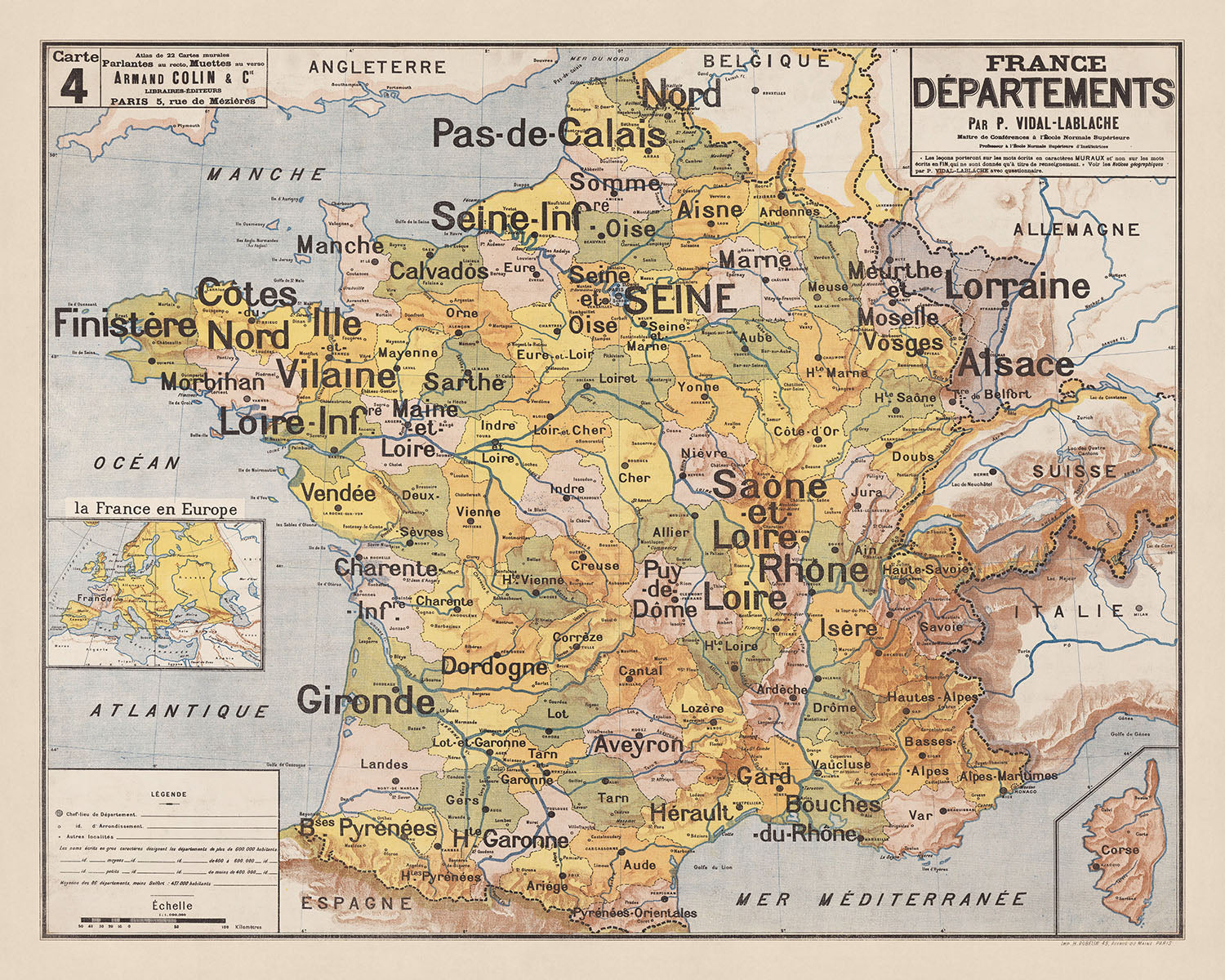
Immergiti nel ricco arazzo della geografia e della storia francese con la mappa "Francia: Dipartimenti", realizzata dal rinomato Paul Vidal de La...
Continua a leggereImmergiti nel ricco arazzo della geografia e della storia francese con la mappa "Francia: Dipartimenti", realizzata dal rinomato Paul Vidal de La Blache nel 1897. Vidal de La Blache, una luminare nel campo della geografia e una figura fondamentale nella sua evoluzione moderna, porta la sua esperienza accademica e la passione per il paesaggio francese in questa dettagliata mappa politica e fisica. Come professore all'École Normale Supérieure e al Collège de France, il suo lavoro non riflette solo il rigore accademico della sua ricerca, ma anche la sua profonda connessione con la terra, rendendo questa mappa una testimonianza della profondità della sua comprensione e apprezzamento delle diverse regioni della Francia.
La mappa stessa emerge da un periodo di profonda trasformazione all'interno della Francia, una nazione che si stava ricostruendo dopo la guerra franco-prussiana e in mezzo ai dolori della nascita della Terza Repubblica. Questo contesto storico dà vita alla mappa "Francia: Dipartimenti", illustrando le nuove divisioni politiche e amministrative con meticolosa attenzione. L'inclusione di città, fiumi, montagne e confini dipartimentali non serve solo come riferimento geografico, ma come una narrazione di resilienza e rinascita, catturando l'essenza di un paese sull'orlo della modernità.
Il capolavoro di Paul Vidal de La Blache è una fusione armoniosa di arte e scienza, con la sua dettagliata rappresentazione della geografia fisica e politica della Francia. Dalle aspre vette delle Alpi e dei Pirenei ai corsi tortuosi dei fiumi Reno e Loira, ogni caratteristica è resa con precisione e chiarezza. La mappa evidenzia anche la posizione strategica della Francia all'interno dell'Europa attraverso confini dettagliati, incluse le sue frontiere costiere con l'Oceano Atlantico, il Mar Mediterraneo e la Manica, sottolineando l'importanza naturale e geopolitica del paese.
Oltre alla sua utilità come strumento di riferimento, la mappa funge anche da strumento educativo, progettata per essere leggibile da tutta la classe. Le caratteristiche esagerate di città, fiumi e nomi dei dipartimenti non sono semplicemente scelte stilistiche, ma miglioramenti deliberati per facilitare l'apprendimento. Questo scopo educativo si allinea con i più ampi obiettivi pedagogici di Vidal de La Blache, rendendo la mappa una risorsa inestimabile sia per studiosi che per appassionati di geografia e storia.
Possedere la mappa "Francia: Dipartimenti" è più di un'acquisizione di un raro artefatto; è un invito a viaggiare attraverso il cuore della Francia, guidati da uno dei geografi più influenti del XIX secolo. È un pezzo che non solo adorna uno spazio con il suo squisito dettaglio e artigianato, ma funge anche da ponte verso il passato, offrendo intuizioni sui contorni geografici e storici che hanno plasmato la Francia. Questa mappa è una celebrazione dell'identità francese, un tributo alla sua resilienza e una testimonianza dell'eredità duratura dei contributi accademici di Paul Vidal de La Blache.
Città e paesi su questa mappa
- Parigi (2.175.601)
- Marsiglia (863.310)
- Lione (522.963)
- Tolosa (479.553)
- Nizza (340.013)
- Nantes (316.786)
- Strasburgo (280.968)
- Montpellier (275.244)
- Bordeaux (257.806)
- Lille (231.491)
- Rennes (216.815)
- Reims (182.462)
- Le Havre (178.906)
- Saint-Étienne (172.023)
- Tolone (171.954)
- Grenoble (158.105)
- Dijon (156.920)
- Angers (154.518)
- Brest (140.064)
- Le Mans (140.043)
- Clermont-Ferrand (140.029)
- Amiens (136.105)
- Aix-en-Provence (144,414)
- Limoges (137,352)
- Tours (136,564)
- Orléans (116,672)
- Rouen (110,755)
- Metz (110,336)
- Nancy (105,329)
- Besançon (115,931)
- Caen (105,336)
- Nîmes (151,876)
- Avignone (94,234)
- Poitiers (88,291)
- Mulhouse (108,033)
- Perpignano (120,154)
- Colmar (68,784)
- La Rochelle (75,735)
- Saint-Quentin (55,690)
- Charleville-Mézières (46,399)
- Tarbes (44,365)
- Arras (41,017)
- Valenciennes (40,782)
- Dunkerque (39,274)
- Cambrai (36,229)
- Douai (35,664)
- Boulogne-sur-Mer (34,503)
- Calais (72,944)
- Lens (34,233)
- Béthune (34,133)
- Montluçon (34,022)
- Nevers (33,220)
- Auxerre (33,023)
- Châteauroux (32,464)
- Blois (32,120)
- Évreux (31,941)
- Bourges (31,713)
- Agen (30,936)
- Montauban (30,696)
- Albi (30,356)
- Roanne (30,147)
- Saint-Brieuc (29,603)
- Quimper (29,224)
- Lorient (28,807)
- Vannes (28,416)
- Cherbourg (28,263)
- Le Puy-en-Velay (27,924)
- Valence (27,666)
- Carcassonne (27,444)
- Narbonne (27,336)
- Auch (27,232)
- Foix (27,183)
- Mende (27,179)
- Privas (27,161)
- Tulle (27,147)
- Ussel (27,133)
- Saint-Flour (27,119)
- Aurillac (27,105)
- Rodez (27,091)
- Figeac (27,077)
- Villefranche-de-Rouergue (27,063)
- Cahors (27,049)
- Gourdon (27,035)
- Sarlat-la-Canéda (27,021)
Caratteristiche e monumenti notevoli
- Alpi
- Massiccio Centrale
- Pirenei
- Monti Jura
- Monti Vosgi
- Monti Ardenne
- Oceano Atlantico
- Mare Mediterraneo
- Mare del Nord
- Canale della Manica
- Baia di Biscaglia
- Fiume Reno
- Fiume Loira
- Fiume Senna
- Fiume Garonna
- Fiume Rodano
- Confini internazionali
- Confini dipartimentali
Contesto storico e di design
- Titolo della mappa: Francia: Dipartimenti
- Data: 1897
- Cartografo/Editore: Paul Vidal de La Blache
- Paul Vidal de La Blache era un geografo e storico francese, considerato uno dei fondatori della geografia moderna.
- La mappa riflette le nuove divisioni politiche e amministrative della Francia in un periodo di grande cambiamento, dopo la guerra franco-prussiana e l'istituzione della Terza Repubblica.
- Progettata come strumento educativo, con caratteristiche esagerate per una facile visibilità in aula.
Si prega di controllare attentamente le immagini per assicurarsi che una specifica città o luogo sia mostrato su questa mappa. Puoi anche contattarci e chiedere di controllare la mappa per te.
Questa mappa appare fantastica in ogni dimensione, ma consiglio sempre di optare per una dimensione più grande se hai spazio. In questo modo puoi facilmente distinguere tutti i dettagli.
Questa mappa appare straordinaria in dimensioni fino a 90in (230cm). Se stai cercando una mappa più grande, per favore contattaci.
Il modello nelle immagini dell'elenco tiene in mano la versione della mappa 16x20in (40x50cm).
La quinta immagine dell'elenco mostra un esempio del mio servizio di personalizzazione della mappa.
Se stai cercando qualcosa di leggermente diverso, dai un'occhiata alla mia collezione delle migliori mappe antiche per vedere se qualcos'altro attira la tua attenzione.
Per favore contattami per verificare se una certa posizione, un punto di riferimento o una caratteristica è mostrata su questa mappa.
Questo sarebbe un meraviglioso regalo per un compleanno, Natale, Festa del Papà, un congedo dal lavoro, un anniversario o una festa di inaugurazione per qualcuno delle aree coperte da questa mappa.
Questa mappa è disponibile come stampa giclée su carta opaca archiviabile senza acidi, oppure puoi acquistarla incorniciata. La cornice è una semplice cornice nera che si adatta alla maggior parte degli stili. Per favore mettiti in contatto se desideri un colore o un materiale diverso per la cornice. Le mie cornici sono rivestite con acrilico super chiaro di grado museale (perspex/acrylite), che è significativamente meno riflettente del vetro, più sicuro e arriverà sempre in perfette condizioni.
This map is also available as a float framed canvas, sometimes known as a shadow gap framed canvas or canvas floater. The map is printed on artist's cotton canvas and then stretched over a handmade box frame. We then "float" the canvas inside a wooden frame, which is available in a range of colours (black, dark brown, oak, antique gold and white). This is a wonderful way to present a map without glazing in front. See some examples of float framed canvas maps and explore the differences between my different finishes.
For something truly unique, this map is also available in "Unique 3D", our trademarked process that dramatically transforms the map so that it has a wonderful sense of depth. We combine the original map with detailed topography and elevation data, so that mountains and the terrain really "pop". For more info and examples of 3D maps, check my Unique 3D page.
Immergiti nel ricco arazzo della geografia e della storia francese con la mappa "Francia: Dipartimenti", realizzata dal rinomato Paul Vidal de La Blache nel 1897. Vidal de La Blache, una luminare nel campo della geografia e una figura fondamentale nella sua evoluzione moderna, porta la sua esperienza accademica e la passione per il paesaggio francese in questa dettagliata mappa politica e fisica. Come professore all'École Normale Supérieure e al Collège de France, il suo lavoro non riflette solo il rigore accademico della sua ricerca, ma anche la sua profonda connessione con la terra, rendendo questa mappa una testimonianza della profondità della sua comprensione e apprezzamento delle diverse regioni della Francia.
La mappa stessa emerge da un periodo di profonda trasformazione all'interno della Francia, una nazione che si stava ricostruendo dopo la guerra franco-prussiana e in mezzo ai dolori della nascita della Terza Repubblica. Questo contesto storico dà vita alla mappa "Francia: Dipartimenti", illustrando le nuove divisioni politiche e amministrative con meticolosa attenzione. L'inclusione di città, fiumi, montagne e confini dipartimentali non serve solo come riferimento geografico, ma come una narrazione di resilienza e rinascita, catturando l'essenza di un paese sull'orlo della modernità.
Il capolavoro di Paul Vidal de La Blache è una fusione armoniosa di arte e scienza, con la sua dettagliata rappresentazione della geografia fisica e politica della Francia. Dalle aspre vette delle Alpi e dei Pirenei ai corsi tortuosi dei fiumi Reno e Loira, ogni caratteristica è resa con precisione e chiarezza. La mappa evidenzia anche la posizione strategica della Francia all'interno dell'Europa attraverso confini dettagliati, incluse le sue frontiere costiere con l'Oceano Atlantico, il Mar Mediterraneo e la Manica, sottolineando l'importanza naturale e geopolitica del paese.
Oltre alla sua utilità come strumento di riferimento, la mappa funge anche da strumento educativo, progettata per essere leggibile da tutta la classe. Le caratteristiche esagerate di città, fiumi e nomi dei dipartimenti non sono semplicemente scelte stilistiche, ma miglioramenti deliberati per facilitare l'apprendimento. Questo scopo educativo si allinea con i più ampi obiettivi pedagogici di Vidal de La Blache, rendendo la mappa una risorsa inestimabile sia per studiosi che per appassionati di geografia e storia.
Possedere la mappa "Francia: Dipartimenti" è più di un'acquisizione di un raro artefatto; è un invito a viaggiare attraverso il cuore della Francia, guidati da uno dei geografi più influenti del XIX secolo. È un pezzo che non solo adorna uno spazio con il suo squisito dettaglio e artigianato, ma funge anche da ponte verso il passato, offrendo intuizioni sui contorni geografici e storici che hanno plasmato la Francia. Questa mappa è una celebrazione dell'identità francese, un tributo alla sua resilienza e una testimonianza dell'eredità duratura dei contributi accademici di Paul Vidal de La Blache.
Città e paesi su questa mappa
- Parigi (2.175.601)
- Marsiglia (863.310)
- Lione (522.963)
- Tolosa (479.553)
- Nizza (340.013)
- Nantes (316.786)
- Strasburgo (280.968)
- Montpellier (275.244)
- Bordeaux (257.806)
- Lille (231.491)
- Rennes (216.815)
- Reims (182.462)
- Le Havre (178.906)
- Saint-Étienne (172.023)
- Tolone (171.954)
- Grenoble (158.105)
- Dijon (156.920)
- Angers (154.518)
- Brest (140.064)
- Le Mans (140.043)
- Clermont-Ferrand (140.029)
- Amiens (136.105)
- Aix-en-Provence (144,414)
- Limoges (137,352)
- Tours (136,564)
- Orléans (116,672)
- Rouen (110,755)
- Metz (110,336)
- Nancy (105,329)
- Besançon (115,931)
- Caen (105,336)
- Nîmes (151,876)
- Avignone (94,234)
- Poitiers (88,291)
- Mulhouse (108,033)
- Perpignano (120,154)
- Colmar (68,784)
- La Rochelle (75,735)
- Saint-Quentin (55,690)
- Charleville-Mézières (46,399)
- Tarbes (44,365)
- Arras (41,017)
- Valenciennes (40,782)
- Dunkerque (39,274)
- Cambrai (36,229)
- Douai (35,664)
- Boulogne-sur-Mer (34,503)
- Calais (72,944)
- Lens (34,233)
- Béthune (34,133)
- Montluçon (34,022)
- Nevers (33,220)
- Auxerre (33,023)
- Châteauroux (32,464)
- Blois (32,120)
- Évreux (31,941)
- Bourges (31,713)
- Agen (30,936)
- Montauban (30,696)
- Albi (30,356)
- Roanne (30,147)
- Saint-Brieuc (29,603)
- Quimper (29,224)
- Lorient (28,807)
- Vannes (28,416)
- Cherbourg (28,263)
- Le Puy-en-Velay (27,924)
- Valence (27,666)
- Carcassonne (27,444)
- Narbonne (27,336)
- Auch (27,232)
- Foix (27,183)
- Mende (27,179)
- Privas (27,161)
- Tulle (27,147)
- Ussel (27,133)
- Saint-Flour (27,119)
- Aurillac (27,105)
- Rodez (27,091)
- Figeac (27,077)
- Villefranche-de-Rouergue (27,063)
- Cahors (27,049)
- Gourdon (27,035)
- Sarlat-la-Canéda (27,021)
Caratteristiche e monumenti notevoli
- Alpi
- Massiccio Centrale
- Pirenei
- Monti Jura
- Monti Vosgi
- Monti Ardenne
- Oceano Atlantico
- Mare Mediterraneo
- Mare del Nord
- Canale della Manica
- Baia di Biscaglia
- Fiume Reno
- Fiume Loira
- Fiume Senna
- Fiume Garonna
- Fiume Rodano
- Confini internazionali
- Confini dipartimentali
Contesto storico e di design
- Titolo della mappa: Francia: Dipartimenti
- Data: 1897
- Cartografo/Editore: Paul Vidal de La Blache
- Paul Vidal de La Blache era un geografo e storico francese, considerato uno dei fondatori della geografia moderna.
- La mappa riflette le nuove divisioni politiche e amministrative della Francia in un periodo di grande cambiamento, dopo la guerra franco-prussiana e l'istituzione della Terza Repubblica.
- Progettata come strumento educativo, con caratteristiche esagerate per una facile visibilità in aula.
Si prega di controllare attentamente le immagini per assicurarsi che una specifica città o luogo sia mostrato su questa mappa. Puoi anche contattarci e chiedere di controllare la mappa per te.
Questa mappa appare fantastica in ogni dimensione, ma consiglio sempre di optare per una dimensione più grande se hai spazio. In questo modo puoi facilmente distinguere tutti i dettagli.
Questa mappa appare straordinaria in dimensioni fino a 90in (230cm). Se stai cercando una mappa più grande, per favore contattaci.
Il modello nelle immagini dell'elenco tiene in mano la versione della mappa 16x20in (40x50cm).
La quinta immagine dell'elenco mostra un esempio del mio servizio di personalizzazione della mappa.
Se stai cercando qualcosa di leggermente diverso, dai un'occhiata alla mia collezione delle migliori mappe antiche per vedere se qualcos'altro attira la tua attenzione.
Per favore contattami per verificare se una certa posizione, un punto di riferimento o una caratteristica è mostrata su questa mappa.
Questo sarebbe un meraviglioso regalo per un compleanno, Natale, Festa del Papà, un congedo dal lavoro, un anniversario o una festa di inaugurazione per qualcuno delle aree coperte da questa mappa.
Questa mappa è disponibile come stampa giclée su carta opaca archiviabile senza acidi, oppure puoi acquistarla incorniciata. La cornice è una semplice cornice nera che si adatta alla maggior parte degli stili. Per favore mettiti in contatto se desideri un colore o un materiale diverso per la cornice. Le mie cornici sono rivestite con acrilico super chiaro di grado museale (perspex/acrylite), che è significativamente meno riflettente del vetro, più sicuro e arriverà sempre in perfette condizioni.
This map is also available as a float framed canvas, sometimes known as a shadow gap framed canvas or canvas floater. The map is printed on artist's cotton canvas and then stretched over a handmade box frame. We then "float" the canvas inside a wooden frame, which is available in a range of colours (black, dark brown, oak, antique gold and white). This is a wonderful way to present a map without glazing in front. See some examples of float framed canvas maps and explore the differences between my different finishes.
For something truly unique, this map is also available in "Unique 3D", our trademarked process that dramatically transforms the map so that it has a wonderful sense of depth. We combine the original map with detailed topography and elevation data, so that mountains and the terrain really "pop". For more info and examples of 3D maps, check my Unique 3D page.
Many of our maps and art prints are chosen as thoughtful gifts for homes, offices, studies and meaningful places.
Choose a framed option for the easiest ready-to-hang gift, or choose an unframed print if the recipient may prefer to select their own frame.
We make orders locally in 23 countries around the world, so gifts can often be produced close to the recipient. This helps them arrive faster, travel more safely, and avoid customs or import duty surprises.
- We can deliver directly to the recipient
- Framed pieces arrive ready to hang
- Unframed prints are carefully packed in a strong protective tube
- Almost every order is made locally, for faster, safer gifting
- 90-day returns give the recipient time to decide
If you are not sure what to choose, please contact us. We can help you pick the right map, size, finish or delivery option.
Most orders are made locally and delivered in around 2–3 working days, depending on the product, size and destination.
We print and frame maps and artwork in 23 countries around the world, so your order is usually made close to you or your recipient. That means faster delivery, less time in transit, and no customs or import duty surprises.
Personalised and customised pieces usually take an extra 1–2 working days, because we prepare your design and send it to you for approval before printing.
Very large framed orders can take a little longer, as they need extra care in production and delivery.
Every order is carefully packaged: unframed prints are sent in a strong protective tube, while framed pieces are securely packed with protective materials around the frame.
If you need your order by a particular date, please contact us before ordering. We’ll check the best production route and delivery option for your location.
Express delivery is available at checkout for most countries. Next-day delivery is available in the UK, US, Singapore and the UAE.
Your order is covered by our 90-day returns policy and 10-year guarantee.
Our standard frame is a gallery-style black ash hardwood frame, with a simple, modern look. It is approximately 20mm (0.8in) wide. You can also view some lovely customer photos of framed maps and art.
We use super-clear acrylic glazing, also known as Perspex or Acrylite, instead of traditional glass. It is lighter, safer, and has lower reflectivity, giving the artwork a clearer, cleaner appearance.
Six standard frame colours are available at no extra cost: black, dark brown, dark grey, oak, white, and antique gold. Custom framing and mounting/matting is also available for customers looking for something more specific.
Most maps, art prints, and illustrations are also available as a framed canvas. We use matte cotton canvas, stretch it over a sustainably sourced wooden box frame, and then float the piece within a wooden outer frame. The finished result is beautifully presented, with no glazing between you and the artwork.
All frames are supplied ready to hang, with either string or brackets fitted to the back. Very large frames will include heavy-duty hanging plates and/or a mounting baton. If you have any questions, please get in touch.
We can also supply old maps and artwork on canvas, foam board, cotton rag, and other materials.
If you would prefer to frame your map or artwork yourself, please read our size guide before ordering.
Every Unique Maps piece begins with an authentic cartographic source or an original design from our London studio.
For our historic maps, we source rare originals from libraries, archives, auction houses and private collections around the world. We carefully restore each map for print—repairing age-related damage, balancing colour and improving clarity while preserving its original detail, texture and character.
Once restored, the map is prepared for your chosen size and finish. Your piece is then printed and, where selected, framed close to its delivery destination.
Our map prints use acid-free 200gsm archival matte paper and fade-resistant pigment inks, creating a rich, non-glossy finish designed to last. Framed maps use crystal-clear optical acrylic and arrive ready to hang.
Canvas, cotton-rag and other specialist presentations are also available. Learn more about our materials and finishes.
Personalising your map
You can add a short title or dedication, mark one meaningful place, or request one considered visual detail. For personalised designs, we send a proof before printing and you can request changes before approval.
For more complex bespoke commissions, contact our design team.
Original or Aged
Choose Original for true-to-source colour, or Aged for a warmer, richer antique character created with our specialist ageing process. See examples of our Aged maps.
Se non sei soddisfatto del tuo ordine per qualsiasi motivo, contattami per un rimborso senza problemi. Si prega di consultare la nostra politica di reso e rimborso per ulteriori informazioni.
Sono molto sicuro che ti piacerà la tua mappa restaurata o la stampa d'arte. Lo faccio dal 1984. Sono un venditore Etsy a 5 stelle. Ho venduto decine di migliaia di mappe e stampe d'arte e ho oltre 5.000 recensioni reali a 5 stelle.
Utilizzo un processo unico per restaurare mappe e opere d'arte che richiede molto tempo e lavoro. Trovare le mappe e le illustrazioni originali può richiedere mesi. Utilizzo tecnologia all'avanguardia e incredibilmente costosa per scannerizzare e restaurarle. Di conseguenza, garantisco che le mie mappe e stampe d'arte siano superiori alle altre - ecco perché posso offrire un rimborso senza problemi.
Quasi tutte le mie mappe e stampe d'arte sembrano fantastiche a grandi dimensioni (200 cm, 6,5 piedi+) e posso anche incorniciarle e consegnarle a te, tramite un corriere speciale per oggetti di grandi dimensioni. Contattami per discutere delle tue esigenze specifiche.
Or try searching for something!


