


Mappa antica del Staffordshire di Samuel Lewis, 1844: Wolverhampton, Stoke-on-Trent, Lichfield, Tamworth, Cannock Chase
20% di sconto su 2 — 33% di sconto su 3
Aggiungi qualsiasi due articoli idonei al tuo carrello per ricevere 20% di sconto. Aggiungi un terzo e sarà gratuito (equivalente a 33% di sconto quando acquisti tre).
Nessun codice necessario — l'offerta si applica automaticamente al checkout.
Valido su tutte le mappe standard e le stampe d'arte fine. Puoi mescolare e abbinare qualsiasi design.
Se desideri spedire articoli a più indirizzi, ti preghiamo di contattarci prima di effettuare il tuo ordine.
Le commissioni personalizzate e su misura sono escluse.
Contattaci se hai domande

Choose your size
Choose your finish


(Maggiori informazioni)
Gift message & custom finish

If you want to add a gift message, or a finish (jigsaw, aluminium board, etc.) that is not available here, please request it in the "order note" when you check out.
Every order is custom made, so if you need the size adjusted slightly, or printed on an unusual material, just let us know. We've done thousands of custom orders over the years, so there's (almost) nothing we can't manage.
You can also contact us before you order, if you prefer!

- Made locally for fast, safe delivery
- No import duty or hidden fees
- Need advice? Message us on WhatsApp
Own a piece of history
7,000+ 5 star reviews


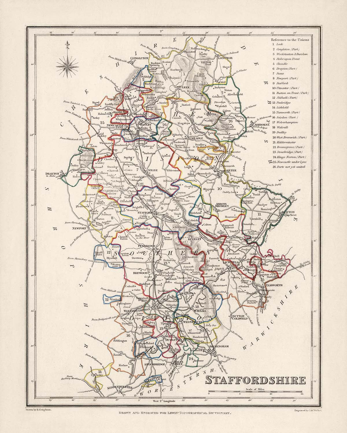
L'Antica Mappa dello Staffordshire di Samuel Lewis, creata nel 1844, è un'opera affascinante che offre uno sguardo sui confini storici dello Staffordshire, in Inghilterra. Questa mappa offre una prospettiva unica sulla regione, mettendo in risalto le sue principali città, i centri abitati e altre caratteristiche affascinanti dell'epoca. È importante notare che, sebbene alcune città moderne possano non essere rappresentate su questa mappa, altre possono comparire con nomi precedenti, aggiungendo un elemento di emozione e scoperta per gli appassionati di mappe e di storia.
Questa mappa, realizzata con meticolosa cura da Samuel Lewis nel 1844, presenta una ricchezza di informazioni sulla Contea dello Staffordshire, in Inghilterra. I suoi dettagli intricati e il design elegante la rendono un'aggiunta affascinante a qualsiasi collezione. La mappa mostra i confini storici dello Staffordshire e mette in evidenza le cinque principali città, i centri abitati e altre caratteristiche notevoli dell'epoca.
Insediamenti notevoli fondati prima del 1840:
- Wolverhampton (985): Fondata nel 985, Wolverhampton è una città vivace nota per il suo patrimonio industriale e la sua ricca storia.
- Stoke-on-Trent (1210): Risalente al 1210, Stoke-on-Trent è rinomata come luogo di nascita dell'industria della ceramica, guadagnandosi il titolo di "Capitale Mondiale della Ceramica".
- Lichfield (7th century): Con una storia che risale al VII secolo, Lichfield è un'affascinante città cattedrale nota per la sua architettura medievale e per essere il luogo di nascita di Samuel Johnson, celebre scrittore e lessicografo.
- Tamworth (7th century): Fondata nel VII secolo, Tamworth è un'antica città mercato ricca di storia, con un castello ben conservato e un passato affascinante come capitale del Regno anglosassone di Mercia.
- Cannock Chase (13th century): Istituita nel XIII secolo, Cannock Chase è un'area di straordinaria bellezza naturale, che comprende un vasto tratto di brughiera, foreste e fauna selvatica.
Ulteriori insediamenti notevoli fondati prima del 1840:
- Stafford (6th century): Fondata nel VI secolo, Stafford è una storica città mercato con un castello normanno e un ricco patrimonio.
- Burton upon Trent (11th century): Risalente all'XI secolo, Burton upon Trent è rinomata per la sua industria birraria ed è sede di diversi birrifici noti.
- Newcastle-under-Lyme (12th century): Istituita nel XII secolo, Newcastle-under-Lyme è un'affascinante città mercato con un impianto stradale medievale e una vivace scena culturale.
- Stone (7th century): Con origini nel VII secolo, Stone è una pittoresca cittadina nota per il suo canale, gli edifici storici e l'annuale festival del cibo e delle bevande.
- Uttoxeter (10th century): Fondata nel X secolo, Uttoxeter è una città mercato famosa per il suo ippodromo e per i suoi legami con la leggendaria storia di Dick Turpin.
... (proseguendo con i restanti 20 insediamenti)
Confini, fiumi e fenomeni naturali notevoli:
- Peak District National Park: Situato nella parte meridionale dello Staffordshire, il Peak District National Park è una splendida area di bellezza naturale, caratterizzata da dolci colline, paesaggi spettacolari e villaggi pittoreschi.
- River Trent: Attraversando la contea, il River Trent è uno dei principali fiumi d'Inghilterra, offre vedute panoramiche e svolge un ruolo significativo nella storia e nell'economia della regione.
- Cannock Chase: Come accennato in precedenza, Cannock Chase non è solo un insediamento, ma anche un’ampia area naturale, che comprende brughiere, foreste e fauna selvatica, rendendola una meta molto apprezzata dagli amanti delle attività all’aperto.
Eventi storici nello Staffordshire (1800-1850):
- 1811: Rivolte luddite: Lo Staffordshire non fu immune al movimento luddista, che mirava a protestare contro la meccanizzazione dell’industria tessile. Durante questo periodo, in varie parti della contea si verificarono rivolte e episodi di distruzione di macchinari.
- 1831: Rivolte per il Reform Act: Il Reform Act del 1832 mirava ad ampliare il diritto di voto, ma la sua approvazione incontrò resistenza. Nello Staffordshire si registrarono rivolte e disordini, mentre la popolazione chiedeva riforme politiche e rappresentanza.
Abbracciate il fascino della storia con la Mappa antica dello Staffordshire di Samuel Lewis, 1844. Questa mappa, riccamente dettagliata, offre uno sguardo al passato, mettendo in risalto le principali città, centri abitati e altre interessanti caratteristiche della regione. Con il suo valore storico e la sua squisita fattura, questa mappa è un acquisto imperdibile per collezionisti, appassionati di storia e chiunque desideri esplorare il ricco patrimonio dello Staffordshire, in Inghilterra.
Controllate attentamente le immagini per assicurarvi che una determinata città o località sia presente su questa mappa. Potete anche contattarci e chiedere di verificare la mappa per voi.
Questa mappa ha un aspetto eccellente in tutte le dimensioni: 12x16in (30.5x41cm), 16x20in (40.5x51cm), 18x24in (45.5x61cm), 24x30in (61x76cm), 32x40in (81.5x102cm) e 40x50in (102x127cm), ma rende ancora meglio se stampata in grande formato.
Posso realizzare splendide stampe di grandi dimensioni di questa mappa fino a 50in (127cm). Contattatemi se cercate formati più grandi, personalizzati o diverse opzioni di cornice.
Il modello nelle immagini dell’inserzione tiene in mano la versione 16x20in (40.5x51cm) di questa mappa.
La quinta immagine dell’inserzione mostra un esempio del mio servizio di personalizzazione delle mappe.
Se cercate qualcosa di leggermente diverso, date un’occhiata alla mia principale collezione di mappe del Regno Unito e dell’Irlanda.
Vi prego di contattarmi per verificare se una certa località, punto di riferimento o caratteristica è presente su questa mappa.
Sarebbe un meraviglioso regalo di compleanno, Natale, Festa del papà, per un collega che lascia il lavoro, anniversario o inaugurazione della casa per qualcuno proveniente dalle zone coperte da questa mappa.
Questa mappa è disponibile come stampa giclée su carta opaca archivistica senza acidi, oppure potete acquistarla incorniciata. La cornice è una bella e semplice cornice nera che si adatta alla maggior parte degli stili. Contattatemi se desiderate un colore o un materiale della cornice diverso. Le mie cornici sono vetrate con acrilico di qualità museale super-trasparente (perspex/acrylite), significativamente meno riflettente del vetro, più sicuro e che arriverà sempre in perfette condizioni.
This map is also available as a float framed canvas, sometimes known as a shadow gap framed canvas or canvas floater. The map is printed on artist's cotton canvas and then stretched over a handmade box frame. We then "float" the canvas inside a wooden frame, which is available in a range of colours (black, dark brown, oak, antique gold and white). This is a wonderful way to present a map without glazing in front. See some examples of float framed canvas maps and explore the differences between my different finishes.
For something truly unique, this map is also available in "Unique 3D", our trademarked process that dramatically transforms the map so that it has a wonderful sense of depth. We combine the original map with detailed topography and elevation data, so that mountains and the terrain really "pop". For more info and examples of 3D maps, check my Unique 3D page.
Many of our maps and art prints are chosen as thoughtful gifts for homes, offices, studies and meaningful places.
Choose a framed option for the easiest ready-to-hang gift, or choose an unframed print if the recipient may prefer to select their own frame.
We make orders locally in 23 countries around the world, so gifts can often be produced close to the recipient. This helps them arrive faster, travel more safely, and avoid customs or import duty surprises.
- We can deliver directly to the recipient
- Framed pieces arrive ready to hang
- Unframed prints are carefully packed in a strong protective tube
- Almost every order is made locally, for faster, safer gifting
- 90-day returns give the recipient time to decide
If you are not sure what to choose, please contact us. We can help you pick the right map, size, finish or delivery option.
Most orders are made locally and delivered in around 2–3 working days, depending on the product, size and destination.
We print and frame maps and artwork in 23 countries around the world, so your order is usually made close to you or your recipient. That means faster delivery, less time in transit, and no customs or import duty surprises.
Personalised and customised pieces usually take an extra 1–2 working days, because we prepare your design and send it to you for approval before printing.
Very large framed orders can take a little longer, as they need extra care in production and delivery.
Every order is carefully packaged: unframed prints are sent in a strong protective tube, while framed pieces are securely packed with protective materials around the frame.
If you need your order by a particular date, please contact us before ordering. We’ll check the best production route and delivery option for your location.
Express delivery is available at checkout for most countries. Next-day delivery is available in the UK, US, Singapore and the UAE.
Your order is covered by our 90-day returns policy and 10-year guarantee.
Our standard frame is a gallery-style black ash hardwood frame, with a simple, modern look. It is approximately 20mm (0.8in) wide. You can also view some lovely customer photos of framed maps and art.
We use super-clear acrylic glazing, also known as Perspex or Acrylite, instead of traditional glass. It is lighter, safer, and has lower reflectivity, giving the artwork a clearer, cleaner appearance.
Six standard frame colours are available at no extra cost: black, dark brown, dark grey, oak, white, and antique gold. Custom framing and mounting/matting is also available for customers looking for something more specific.
Most maps, art prints, and illustrations are also available as a framed canvas. We use matte cotton canvas, stretch it over a sustainably sourced wooden box frame, and then float the piece within a wooden outer frame. The finished result is beautifully presented, with no glazing between you and the artwork.
All frames are supplied ready to hang, with either string or brackets fitted to the back. Very large frames will include heavy-duty hanging plates and/or a mounting baton. If you have any questions, please get in touch.
We can also supply old maps and artwork on canvas, foam board, cotton rag, and other materials.
If you would prefer to frame your map or artwork yourself, please read our size guide before ordering.
My maps are extremely high quality reproductions of original maps.
I source original, rare maps from libraries, auction houses and private collections around the world, restore them at my London workshop, and then use specialist giclée inks and printers to create beautiful maps that look even better than the original.
My maps are printed on acid-free archival matte (not glossy) paper that feels very high quality and almost like card. In technical terms the paper weight/thickness is 10mil/200gsm. It's perfect for framing.
I print with Epson ultrachrome giclée UV fade resistant pigment inks - some of the best inks you can find.
I can also make maps on canvas, cotton rag and other exotic materials.
Learn more about The Unique Maps Co.
Map personalisation
If you're looking for the perfect anniversary or housewarming gift, I can personalise your map to make it truly unique. For example, I can add a short message, or highlight an important location, or add your family's coat of arms.
The options are almost infinite. Please see my map personalisation page for some wonderful examples of what's possible.
To order a personalised map, select "personalise your map" before adding it to your basket.
Get in touch if you're looking for more complex customisations and personalisations.
Map ageing
I have been asked hundreds of times over the years by customers if they could buy a map that looks even older.
Well, now you can, by selecting Aged before you add a map to your basket.
All the product photos you see on this page show the map in its Original form. This is what the map looks like today.
If you select Aged, I will age your map by hand, using a special and unique process developed through years of studying old maps, talking to researchers to understand the chemistry of aging paper, and of course... lots of practice!
If you're unsure, stick to the Original colour of the map. If you want something a bit darker and older looking, go for Aged.
Se non sei soddisfatto del tuo ordine per qualsiasi motivo, contattami per un rimborso senza problemi. Si prega di consultare la nostra politica di reso e rimborso per ulteriori informazioni.
Sono molto sicuro che ti piacerà la tua mappa restaurata o la stampa d'arte. Lo faccio dal 1984. Sono un venditore Etsy a 5 stelle. Ho venduto decine di migliaia di mappe e stampe d'arte e ho oltre 5.000 recensioni reali a 5 stelle.
Utilizzo un processo unico per restaurare mappe e opere d'arte che richiede molto tempo e lavoro. Trovare le mappe e le illustrazioni originali può richiedere mesi. Utilizzo tecnologia all'avanguardia e incredibilmente costosa per scannerizzare e restaurarle. Di conseguenza, garantisco che le mie mappe e stampe d'arte siano superiori alle altre - ecco perché posso offrire un rimborso senza problemi.
Quasi tutte le mie mappe e stampe d'arte sembrano fantastiche a grandi dimensioni (200 cm, 6,5 piedi+) e posso anche incorniciarle e consegnarle a te, tramite un corriere speciale per oggetti di grandi dimensioni. Contattami per discutere delle tue esigenze specifiche.
Or try searching for something!


