


Mappa antica del fiume Danubio: Visscher, 1690
L’offerta del Collezionista
Scegli due opere idonee e ricevi il 20% di sconto su entrambe. Scegline tre e quella al prezzo più basso è in omaggio, con un risparmio massimo del 33%.
Abbina liberamente mappe standard idonee e stampe d’arte fine art. Non è richiesto alcun codice; l’offerta viene applicata automaticamente al checkout.
Sono incluse le configurazioni standard su ordinazione. Sono esclusi formati su misura, design personalizzati e lavori su commissione.
Hai bisogno di consegne a indirizzi diversi? Contattaci prima di effettuare l’ordine.L’offerta del Collezionista
Scegli due opere idonee e ricevi il 20% di sconto su entrambe. Scegline tre e quella al prezzo più basso è in omaggio, con un risparmio massimo del 33%.
Abbina liberamente mappe standard idonee e stampe d’arte fine art. Non è richiesto alcun codice; l’offerta viene applicata automaticamente al checkout.
Sono incluse le configurazioni standard su ordinazione. Sono esclusi formati su misura, design personalizzati e lavori su commissione.
Hai bisogno di consegne a indirizzi diversi? Contattaci prima di effettuare l’ordine.
Restaurata dalla mappa originale del 1690 e stampata in qualità museale. Leggi la storia dietro questa mappa
Choose your size
Choose your finish


(Maggiori informazioni)
Gift message & custom finish

If you want to add a gift message, or a finish (jigsaw, aluminium board, etc.) that is not available here, please request it in the "order note" when you check out.
Every order is custom made, so if you need the size adjusted slightly, or printed on an unusual material, just let us know. We've done thousands of custom orders over the years, so there's (almost) nothing we can't manage.
You can also contact us before you order, if you prefer!

- Prodotto localmente. Consegna sicura
- Nessun dazio o costo nascosto
- Serve aiuto? Chiamaci o messaggio su WhatsApp
Own a piece of history
8,000+ five-star reviews


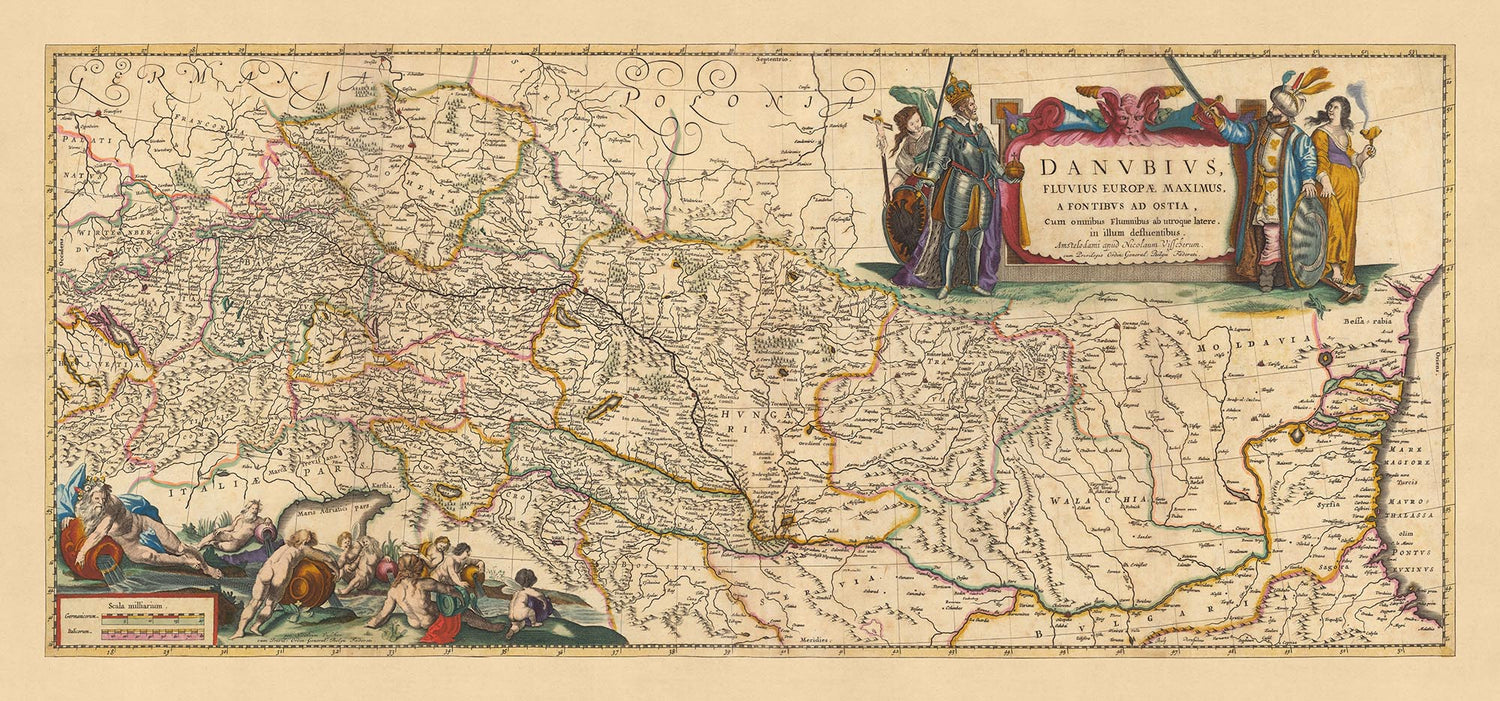
Questa mappa squisita, 'Danubius Fluvius Europae Maximus, a Fontibus Ad Ostia : Cum omnibus Fluminibus, ab utroque latere, in illum defluentibus', è...
Continua a leggereQuesta mappa squisita, 'Danubius Fluvius Europae Maximus, a Fontibus Ad Ostia : Cum omnibus Fluminibus, ab utroque latere, in illum defluentibus', è stata meticolosamente realizzata da Nicolaes Visscher II nel 1690. Tradotto dal latino, il titolo significa 'Il Danubio, il Fiume più Grande d'Europa, dalle Fonti alle Bocche: Con tutti i Fiumi, su entrambi i lati, che vi affluiscono'. Questa mappa è una testimonianza dell'abilità cartografica di Visscher e un riflesso del vivo interesse dell'epoca per la geografia e l'esplorazione.
Il focus di questa mappa è il fiume Danubio, il secondo fiume più lungo d'Europa, che si estende dalla sua sorgente alla sua foce. Il fiume si snoda attraverso varie regioni, fungendo da importante via d'acqua per il commercio e il trasporto. La mappa cattura il viaggio del fiume attraverso paesaggi diversi e oltre i confini politici, rivelando un affascinante istantanea dell'Europa alla fine del XVII secolo.
Città significative lungo il fiume Danubio sono illustrate in modo splendido, tra cui Vienna, Budapest, Praga, Bucarest e Zagabria. Ogni città è rappresentata con un notevole livello di dettaglio, mostrando la capacità di Visscher di combinare elementi artistici con l'accuratezza geografica. Queste città, alcune delle quali erano importanti centri di potere durante il periodo, forniscono un contesto storico alla mappa e uno sguardo sulle dinamiche politiche dell'epoca.
Oltre alle città, la mappa presenta anche vari monumenti e caratteristiche geografiche. L'intricata rete di fiumi che confluiscono nel Danubio è attentamente tracciata, dimostrando l'interconnessione della regione. La mappa offre una vista completa dell'area di drenaggio del Danubio, fornendo spunti sui fenomeni naturali che hanno plasmato lo sviluppo del continente.
Questa mappa è più di una semplice rappresentazione geografica; è un documento storico che racconta la storia dell'Europa durante un periodo di cambiamenti significativi e esplorazione. I suoi ricchi dettagli e la precisa cartografia la rendono un'aggiunta preziosa a qualsiasi collezione, offrendo agli spettatori la possibilità di viaggiare indietro nel tempo ed esplorare i paesaggi, le città e le vie navigabili dell'Europa del XVII secolo.
Alcuni dei luoghi significativi mostrati su questa mappa:
Impero Romano Sacro
- Vienna: Conosciuta come Wien in tedesco, era la capitale del Sacro Romano Impero ed è nota per la sua importanza culturale e politica.
- Praga: Conosciuta come Praha, era la capitale del Regno di Boemia ed è nota per la sua bellezza architettonica e importanza storica.
- Regensburg: Un importante centro commerciale e la sede della Dieta Perpetua di Regensburg.
- Nuremberg: Conosciuta come Nürnberg, era un importante centro culturale, economico e scientifico.
Regno d'Ungheria
- Budapest: Era due città separate, Buda e Pest, fino al 1873. Nota per la sua posizione strategica e le terme.
- Esztergom: La capitale dell'Ungheria fino alla metà del XIII secolo, nota per la sua cattedrale, la Basilica di Esztergom.
Impero Ottomano
- Belgrado: Conosciuta come Beograd, era un importante avamposto militare e la porta verso l'Europa centrale.
- Bucarest: Conosciuta come București, era una città fiorente, che in seguito divenne la capitale della Romania.
Confini notevoli con nazioni vicine, fiumi, parchi nazionali, canyon o altri fenomeni naturali:
- Il fiume Danubio, il secondo fiume più lungo d'Europa, una importante via d'acqua per il commercio.
- La Foresta Nera, una regione montuosa nel sud-ovest della Germania, nota per i suoi boschi fitti.
- Le Montagne Carpazie, una catena montuosa che attraversa l'Europa Centrale e Orientale.
- Le Alpi Dinariche, una catena montuosa nell'Europa meridionale e sud-orientale.
- Lo Stretto del Bosforo, uno stretto naturale che collega il Mar Nero con il Mar di Marmara.
Eventi storici notevoli in questa regione tra il 1600 e il 1690:
- La Guerra dei Trent'anni (1618-1648), un conflitto importante che devastò l'Europa, in particolare il Sacro Romano Impero.
- La Grande Guerra Turca (1683-1699), dove la Santa Lega respinse l'espansione dell'Impero Ottomano in Europa.
- La Battaglia di Vienna nel 1683, dove l'assedio ottomano di Vienna fu spezzato dal Sacro Romano Impero e dal Commonwealth polacco-lituano.
Si prega di controllare attentamente le immagini per assicurarsi che una specifica città o luogo sia mostrato su questa mappa. Puoi anche contattarci e chiedere di controllare la mappa per te.
Questa mappa appare fantastica in tutte le dimensioni: 18x8in (46x22cm), 24x11in (61x29cm), 36x17in (91x44cm), 45x21in (114x54cm), 50x24in (127x60cm), 60x29in (152x73cm) e 70x33in (178x85cm), ma appare ancora meglio quando stampata in grande.
Posso creare bellissime stampe di grandi dimensioni di questa mappa fino a 90in (229cm). Si prega di contattarmi se stai cercando opzioni di incorniciatura più grandi, personalizzate o diverse.
La quinta immagine di elenco mostra un esempio del mio servizio di personalizzazione della mappa.
Se stai cercando qualcosa di leggermente diverso, dai un'occhiata alla mia collezione delle migliori vecchie mappe d'Europa e delle città europee per vedere se qualcosa attira la tua attenzione.
Si prega di contattarmi per verificare se una certa posizione, punto di riferimento o caratteristica è mostrata su questa mappa.
Questa sarebbe un meraviglioso regalo per un compleanno, Natale, Festa del Papà, partenza dal lavoro, anniversario o inaugurazione della casa per qualcuno delle aree coperte da questa mappa.
Questa mappa è disponibile come stampa giclée su carta opaca archiviata senza acidi, oppure puoi acquistarla incorniciata. La cornice è una semplice cornice nera che si adatta alla maggior parte degli stili. Si prega di contattarmi se desideri un colore o materiale di cornice diverso. Le mie cornici sono dotate di vetro acrilico super chiaro di qualità museale (perspex/acrylite), che è significativamente meno riflettente del vetro, più sicuro e arriverà sempre in perfette condizioni.
This map is also available as a float framed canvas, sometimes known as a shadow gap framed canvas or canvas floater. The map is printed on artist's cotton canvas and then stretched over a handmade box frame. We then "float" the canvas inside a wooden frame, which is available in a range of colours (black, dark brown, oak, antique gold and white). This is a wonderful way to present a map without glazing in front. See some examples of float framed canvas maps and explore the differences between my different finishes.
For something truly unique, this map is also available in "Unique 3D", our trademarked process that dramatically transforms the map so that it has a wonderful sense of depth. We combine the original map with detailed topography and elevation data, so that mountains and the terrain really "pop". For more info and examples of 3D maps, check my Unique 3D page.
Questa mappa squisita, 'Danubius Fluvius Europae Maximus, a Fontibus Ad Ostia : Cum omnibus Fluminibus, ab utroque latere, in illum defluentibus', è stata meticolosamente realizzata da Nicolaes Visscher II nel 1690. Tradotto dal latino, il titolo significa 'Il Danubio, il Fiume più Grande d'Europa, dalle Fonti alle Bocche: Con tutti i Fiumi, su entrambi i lati, che vi affluiscono'. Questa mappa è una testimonianza dell'abilità cartografica di Visscher e un riflesso del vivo interesse dell'epoca per la geografia e l'esplorazione.
Il focus di questa mappa è il fiume Danubio, il secondo fiume più lungo d'Europa, che si estende dalla sua sorgente alla sua foce. Il fiume si snoda attraverso varie regioni, fungendo da importante via d'acqua per il commercio e il trasporto. La mappa cattura il viaggio del fiume attraverso paesaggi diversi e oltre i confini politici, rivelando un affascinante istantanea dell'Europa alla fine del XVII secolo.
Città significative lungo il fiume Danubio sono illustrate in modo splendido, tra cui Vienna, Budapest, Praga, Bucarest e Zagabria. Ogni città è rappresentata con un notevole livello di dettaglio, mostrando la capacità di Visscher di combinare elementi artistici con l'accuratezza geografica. Queste città, alcune delle quali erano importanti centri di potere durante il periodo, forniscono un contesto storico alla mappa e uno sguardo sulle dinamiche politiche dell'epoca.
Oltre alle città, la mappa presenta anche vari monumenti e caratteristiche geografiche. L'intricata rete di fiumi che confluiscono nel Danubio è attentamente tracciata, dimostrando l'interconnessione della regione. La mappa offre una vista completa dell'area di drenaggio del Danubio, fornendo spunti sui fenomeni naturali che hanno plasmato lo sviluppo del continente.
Questa mappa è più di una semplice rappresentazione geografica; è un documento storico che racconta la storia dell'Europa durante un periodo di cambiamenti significativi e esplorazione. I suoi ricchi dettagli e la precisa cartografia la rendono un'aggiunta preziosa a qualsiasi collezione, offrendo agli spettatori la possibilità di viaggiare indietro nel tempo ed esplorare i paesaggi, le città e le vie navigabili dell'Europa del XVII secolo.
Alcuni dei luoghi significativi mostrati su questa mappa:
Impero Romano Sacro
- Vienna: Conosciuta come Wien in tedesco, era la capitale del Sacro Romano Impero ed è nota per la sua importanza culturale e politica.
- Praga: Conosciuta come Praha, era la capitale del Regno di Boemia ed è nota per la sua bellezza architettonica e importanza storica.
- Regensburg: Un importante centro commerciale e la sede della Dieta Perpetua di Regensburg.
- Nuremberg: Conosciuta come Nürnberg, era un importante centro culturale, economico e scientifico.
Regno d'Ungheria
- Budapest: Era due città separate, Buda e Pest, fino al 1873. Nota per la sua posizione strategica e le terme.
- Esztergom: La capitale dell'Ungheria fino alla metà del XIII secolo, nota per la sua cattedrale, la Basilica di Esztergom.
Impero Ottomano
- Belgrado: Conosciuta come Beograd, era un importante avamposto militare e la porta verso l'Europa centrale.
- Bucarest: Conosciuta come București, era una città fiorente, che in seguito divenne la capitale della Romania.
Confini notevoli con nazioni vicine, fiumi, parchi nazionali, canyon o altri fenomeni naturali:
- Il fiume Danubio, il secondo fiume più lungo d'Europa, una importante via d'acqua per il commercio.
- La Foresta Nera, una regione montuosa nel sud-ovest della Germania, nota per i suoi boschi fitti.
- Le Montagne Carpazie, una catena montuosa che attraversa l'Europa Centrale e Orientale.
- Le Alpi Dinariche, una catena montuosa nell'Europa meridionale e sud-orientale.
- Lo Stretto del Bosforo, uno stretto naturale che collega il Mar Nero con il Mar di Marmara.
Eventi storici notevoli in questa regione tra il 1600 e il 1690:
- La Guerra dei Trent'anni (1618-1648), un conflitto importante che devastò l'Europa, in particolare il Sacro Romano Impero.
- La Grande Guerra Turca (1683-1699), dove la Santa Lega respinse l'espansione dell'Impero Ottomano in Europa.
- La Battaglia di Vienna nel 1683, dove l'assedio ottomano di Vienna fu spezzato dal Sacro Romano Impero e dal Commonwealth polacco-lituano.
Si prega di controllare attentamente le immagini per assicurarsi che una specifica città o luogo sia mostrato su questa mappa. Puoi anche contattarci e chiedere di controllare la mappa per te.
Questa mappa appare fantastica in tutte le dimensioni: 18x8in (46x22cm), 24x11in (61x29cm), 36x17in (91x44cm), 45x21in (114x54cm), 50x24in (127x60cm), 60x29in (152x73cm) e 70x33in (178x85cm), ma appare ancora meglio quando stampata in grande.
Posso creare bellissime stampe di grandi dimensioni di questa mappa fino a 90in (229cm). Si prega di contattarmi se stai cercando opzioni di incorniciatura più grandi, personalizzate o diverse.
La quinta immagine di elenco mostra un esempio del mio servizio di personalizzazione della mappa.
Se stai cercando qualcosa di leggermente diverso, dai un'occhiata alla mia collezione delle migliori vecchie mappe d'Europa e delle città europee per vedere se qualcosa attira la tua attenzione.
Si prega di contattarmi per verificare se una certa posizione, punto di riferimento o caratteristica è mostrata su questa mappa.
Questa sarebbe un meraviglioso regalo per un compleanno, Natale, Festa del Papà, partenza dal lavoro, anniversario o inaugurazione della casa per qualcuno delle aree coperte da questa mappa.
Questa mappa è disponibile come stampa giclée su carta opaca archiviata senza acidi, oppure puoi acquistarla incorniciata. La cornice è una semplice cornice nera che si adatta alla maggior parte degli stili. Si prega di contattarmi se desideri un colore o materiale di cornice diverso. Le mie cornici sono dotate di vetro acrilico super chiaro di qualità museale (perspex/acrylite), che è significativamente meno riflettente del vetro, più sicuro e arriverà sempre in perfette condizioni.
This map is also available as a float framed canvas, sometimes known as a shadow gap framed canvas or canvas floater. The map is printed on artist's cotton canvas and then stretched over a handmade box frame. We then "float" the canvas inside a wooden frame, which is available in a range of colours (black, dark brown, oak, antique gold and white). This is a wonderful way to present a map without glazing in front. See some examples of float framed canvas maps and explore the differences between my different finishes.
For something truly unique, this map is also available in "Unique 3D", our trademarked process that dramatically transforms the map so that it has a wonderful sense of depth. We combine the original map with detailed topography and elevation data, so that mountains and the terrain really "pop". For more info and examples of 3D maps, check my Unique 3D page.
Many of our maps and art prints are chosen as thoughtful gifts for homes, offices, studies and meaningful places.
Choose a framed option for the easiest ready-to-hang gift, or choose an unframed print if the recipient may prefer to select their own frame.
We make orders locally in 23 countries around the world, so gifts can often be produced close to the recipient. This helps them arrive faster, travel more safely, and avoid customs or import duty surprises.
- We can deliver directly to the recipient
- Framed pieces arrive ready to hang
- Unframed prints are carefully packed in a strong protective tube
- Almost every order is made locally, for faster, safer gifting
- 90-day returns give the recipient time to decide
If you are not sure what to choose, please contact us. We can help you pick the right map, size, finish or delivery option.
Most orders are made locally and delivered in around 2–3 working days, depending on the product, size and destination.
We print and frame maps and artwork in 23 countries around the world, so your order is usually made close to you or your recipient. That means faster delivery, less time in transit, and no customs or import duty surprises.
Personalised and customised pieces usually take an extra 1–2 working days, because we prepare your design and send it to you for approval before printing.
Very large framed orders can take a little longer, as they need extra care in production and delivery.
Every order is carefully packaged: unframed prints are sent in a strong protective tube, while framed pieces are securely packed with protective materials around the frame.
If you need your order by a particular date, please contact us before ordering. We’ll check the best production route and delivery option for your location.
Express delivery is available at checkout for most countries. Next-day delivery is available in the UK, US, Singapore and the UAE.
Your order is covered by our 90-day returns policy and 10-year guarantee.
Our standard frame is a gallery-style black ash hardwood frame, with a simple, modern look. It is approximately 20mm (0.8in) wide. You can also view some lovely customer photos of framed maps and art.
We use super-clear acrylic glazing, also known as Perspex or Acrylite, instead of traditional glass. It is lighter, safer, and has lower reflectivity, giving the artwork a clearer, cleaner appearance.
Six standard frame colours are available at no extra cost: black, dark brown, dark grey, oak, white, and antique gold. Custom framing and mounting/matting is also available for customers looking for something more specific.
Most maps, art prints, and illustrations are also available as a framed canvas. We use matte cotton canvas, stretch it over a sustainably sourced wooden box frame, and then float the piece within a wooden outer frame. The finished result is beautifully presented, with no glazing between you and the artwork.
All frames are supplied ready to hang, with either string or brackets fitted to the back. Very large frames will include heavy-duty hanging plates and/or a mounting baton. If you have any questions, please get in touch.
We can also supply old maps and artwork on canvas, foam board, cotton rag, and other materials.
If you would prefer to frame your map or artwork yourself, please read our size guide before ordering.
My maps are extremely high quality reproductions of original maps.
I source original, rare maps from libraries, auction houses and private collections around the world, restore them at my London workshop, and then use specialist giclée inks and printers to create beautiful maps that look even better than the original.
My maps are printed on acid-free archival matte (not glossy) paper that feels very high quality and almost like card. In technical terms the paper weight/thickness is 10mil/200gsm. It's perfect for framing.
I print with Epson ultrachrome giclée UV fade resistant pigment inks - some of the best inks you can find.
I can also make maps on canvas, cotton rag and other exotic materials.
Learn more about The Unique Maps Co.
Map personalisation
If you're looking for the perfect anniversary or housewarming gift, I can personalise your map to make it truly unique. For example, I can add a short message, or highlight an important location, or add your family's coat of arms.
The options are almost infinite. Please see my map personalisation page for some wonderful examples of what's possible.
To order a personalised map, select "personalise your map" before adding it to your basket.
Get in touch if you're looking for more complex customisations and personalisations.
Map ageing
I have been asked hundreds of times over the years by customers if they could buy a map that looks even older.
Well, now you can, by selecting Aged before you add a map to your basket.
All the product photos you see on this page show the map in its Original form. This is what the map looks like today.
If you select Aged, I will age your map by hand, using a special and unique process developed through years of studying old maps, talking to researchers to understand the chemistry of aging paper, and of course... lots of practice!
If you're unsure, stick to the Original colour of the map. If you want something a bit darker and older looking, go for Aged.
Se non sei soddisfatto del tuo ordine per qualsiasi motivo, contattami per un rimborso senza problemi. Si prega di consultare la nostra politica di reso e rimborso per ulteriori informazioni.
Sono molto sicuro che ti piacerà la tua mappa restaurata o la stampa d'arte. Lo faccio dal 1984. Sono un venditore Etsy a 5 stelle. Ho venduto decine di migliaia di mappe e stampe d'arte e ho oltre 5.000 recensioni reali a 5 stelle.
Utilizzo un processo unico per restaurare mappe e opere d'arte che richiede molto tempo e lavoro. Trovare le mappe e le illustrazioni originali può richiedere mesi. Utilizzo tecnologia all'avanguardia e incredibilmente costosa per scannerizzare e restaurarle. Di conseguenza, garantisco che le mie mappe e stampe d'arte siano superiori alle altre - ecco perché posso offrire un rimborso senza problemi.
Quasi tutte le mie mappe e stampe d'arte sembrano fantastiche a grandi dimensioni (200 cm, 6,5 piedi+) e posso anche incorniciarle e consegnarle a te, tramite un corriere speciale per oggetti di grandi dimensioni. Contattami per discutere delle tue esigenze specifiche.
Or try searching for something!


