


Mappa antica dello Utah e del Colorado di J. H. Colton, 1873: Salt Lake City, Denver, Provo, Colorado Springs, Fort Collins
20% di sconto su 2 — 33% di sconto su 3
Aggiungi qualsiasi due articoli idonei al tuo carrello per ricevere 20% di sconto. Aggiungi un terzo e sarà gratuito (equivalente a 33% di sconto quando acquisti tre).
Nessun codice necessario — l'offerta si applica automaticamente al checkout.
Valido su tutte le mappe standard e le stampe d'arte fine. Puoi mescolare e abbinare qualsiasi design.
Se desideri spedire articoli a più indirizzi, ti preghiamo di contattarci prima di effettuare il tuo ordine.
Le commissioni personalizzate e su misura sono escluse.
Contattaci se hai domande

Choose your size
Choose your finish


(Maggiori informazioni)
Gift message & custom finish

If you want to add a gift message, or a finish (jigsaw, aluminium board, etc.) that is not available here, please request it in the "order note" when you check out.
Every order is custom made, so if you need the size adjusted slightly, or printed on an unusual material, just let us know. We've done thousands of custom orders over the years, so there's (almost) nothing we can't manage.
You can also contact us before you order, if you prefer!

- Made locally for fast, safe delivery
- No import duty or hidden fees
- Need advice? Message us on WhatsApp
Own a piece of history
7,000+ 5 star reviews


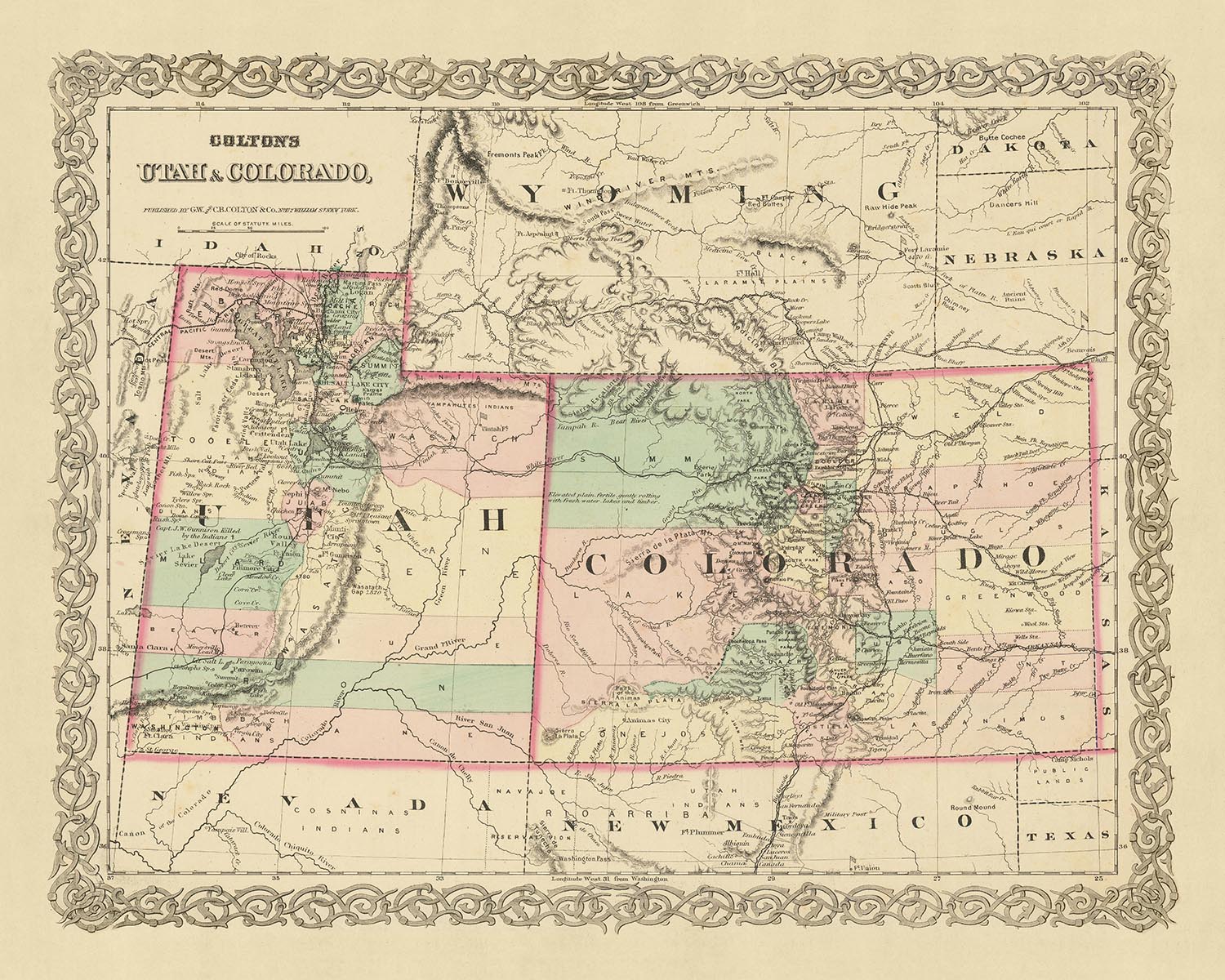
Questa mappa, opera del rinomato cartografo americano J. H. Colton, risale al 1873, un periodo storico in cui gli Stati Uniti erano ancora nelle fasi iniziali del loro sviluppo. Offre un’istantanea unica degli stati di Utah e Colorado, fornendo uno sguardo affascinante sul passato, quando molti insediamenti dovevano ancora essere fondati e il paesaggio era profondamente diverso da quello che conosciamo oggi.
In quest’epoca, la regione era ancora oggetto di esplorazioni e rilevamenti cartografici, con molti insediamenti che stavano appena iniziando a radicarsi. La mappa, pertanto, testimonia la natura dinamica della storia, riflettendo i cambiamenti avvenuti negli ultimi 150 anni. I nomi e i confini rappresentati sulla mappa possono essere evoluti o essere cambiati completamente, rendendo questo pezzo un manufatto intrigante per chi è interessato alla geografia storica degli Stati Uniti.
La mappa presenta i cinque insediamenti più rilevanti dell’epoca in Utah e Colorado: Salt Lake City, Denver, Provo, Colorado Springs e Fort Collins. Ognuno di questi insediamenti ha una propria storia e importanza, e la loro rappresentazione su questa mappa offre un affascinante sguardo sul loro sviluppo iniziale.
Salt Lake City, la capitale e città più popolosa dello Utah, fu fondata nel 1847 da Brigham Young e altri seguaci della Chiesa di Gesù Cristo dei Santi degli Ultimi Giorni. Denver, capitale del Colorado, fu fondata durante la corsa all’oro di Pike’s Peak nel 1858. Provo, situata nello Utah, fu colonizzata da 33 famiglie mormoni nel 1849 ed è oggi sede della Brigham Young University.
Colorado Springs, fondata nel 1871, era nota per la sua bellezza paesaggistica ed era spesso definita "Little London" per la sua popolarità tra i turisti inglesi. Fort Collins, fondata come avamposto militare dell’Esercito degli Stati Uniti nel 1864, è oggi una città vivace e sede della Colorado State University.
Questa mappa di J. H. Colton è un pezzo di grande valore per collezionisti, storici e chiunque abbia interesse per la storia delle origini degli Stati Uniti. Offre una prospettiva unica sullo sviluppo di Utah e Colorado, fungendo da finestra sul passato e da testimonianza del duraturo valore della cartografia. I dettagli intricati e il significato storico della mappa la rendono un manufatto davvero notevole, offrendo un ricco intreccio di storia che continua ad affascinare e ispirare.
Utah
- Salt Lake City (1847): Storicamente nota come Great Salt Lake City, è rilevante in quanto sede della Chiesa di Gesù Cristo dei Santi degli Ultimi Giorni (Chiesa LDS).
- Provo (1849): Nota per essere la sede della Brigham Young University, fondata dalla Chiesa LDS.
- Ogden (1846): Storicamente nota come Fort Buenaventura, fu un importante nodo ferroviario.
- Logan (1859): Nota per essere la sede della Utah State University.
- St. George (1861): Rilevante per il suo clima mite e per essere la sede della Dixie State University.
- Fillmore (1851): Chiamata così in onore del presidente Millard Fillmore, fu la prima capitale dello Utah.
- Lehi (1850): Storicamente nota come Dry Creek, è rilevante per il suo primo coinvolgimento nella coltivazione della barbabietola da zucchero.
- Cedar City (1851): Nota per la vicinanza a ricchi giacimenti di ferro e per lo Utah Shakespeare Festival.
- Brigham City (1851): Nota per i suoi frutteti di pesche e per la celebrazione annuale del Peach Days.
- Richfield (1864) : Fondata come comunità agricola, è la città più grande dello Utah centrale.
Colorado
- Denver (1858): Storicamente nota come Denver City, fu una città mineraria durante la corsa all’oro.
- Colorado Springs (1871): Conosciuta per la sua bellezza paesaggistica e la vicinanza a Pikes Peak.
- Boulder (1859): Fondata come base per i minatori, oggi ospita l’Università del Colorado.
- Golden (1859): Storicamente nota come Golden City, fu la capitale del Territorio del Colorado.
- Pueblo (1842): Fondata come Fort Pueblo, fu un importante avamposto commerciale.
- Leadville (1859): Conosciuta per l’estrazione dell’argento, è una delle città incorporate più alte degli Stati Uniti.
- Greeley (1869): Nota per la sua società utopica sperimentale, la Union Colony.
- Fort Collins (1864): Fondato come avamposto militare, oggi ospita la Colorado State University.
- Durango (1880): Nota per la ferrovia a scartamento ridotto Durango and Silverton.
- Canon City (1858): Conosciuta per i suoi ricchi siti fossiliferi e il Royal Gorge Bridge.
Tribù dei Nativi Americani
- Tribù Ute: Autoctona dello Utah, nota per il suo stile di vita basato su caccia e raccolta.
- Tribù Shoshone: Occupava parti dello Utah settentrionale, nota per la sua cultura equestre.
- Tribù Paiute: Abitava parti dello Utah meridionale, nota per la ceramica e la cesteria.
- Tribù Cheyenne: Originaria del Colorado, nota per la sua cultura guerriera.
- Tribù Arapaho: Occupava parti del Colorado, nota per il suo carattere pacifico e le pratiche commerciali.
Attrazioni naturali
- Great Salt Lake: Il più grande lago salato dell’emisfero occidentale.
- Parco nazionale delle Rocky Mountains: Conosciuto per i suoi splendidi panorami montani.
- Fiume Colorado: Famoso per aver scavato il Grand Canyon.
- Pikes Peak: La montagna più visitata del Nord America.
- Garden of the Gods: Conosciuto per le sue imponenti formazioni rocciose di arenaria.
Eventi storici
- Corsa all’oro di Pike's Peak (1858-1861): Portò alla creazione del Territorio del Colorado.
- Guerra dello Utah (1857-1858): Un conflitto tra il governo degli Stati Uniti e la Chiesa LDS.
- Guerra del Colorado (1863-1865): Un conflitto tra gli Stati Uniti e le tribù Cheyenne, Arapaho e Sioux.
- Creazione del Territorio del Colorado (1861): Formato da parti dei territori del Kansas, del Nebraska, dello Utah e del Nuovo Messico.
- Collegamento della ferrovia transcontinentale (1869): Promontory Summit, Utah divenne il punto d’incontro delle ferrovie Union Pacific e Central Pacific.
Si prega di controllare attentamente le immagini per assicurarsi che su questa mappa sia mostrata una specifica città o località. Potete anche contattarci e chiederci di verificare la mappa per voi.
Questa mappa ha un aspetto straordinario in tutte le dimensioni: 18x12in (46x30.5cm), 18x24in (45.5x61cm), 24x36in (61x91.5cm), 30x45in (76x114.5cm), 33x50in (84x127cm), 40x60in (102x153cm) e 47x70in (120x178cm), ma rende ancora meglio se stampata in grande formato.
Posso creare splendide stampe di grandi dimensioni di questa mappa fino a 70 pollici (178 cm). Contattatemi se cercate formati più grandi, personalizzati o diverse opzioni di cornice.
Il modello nelle immagini dell'inserzione tiene in mano la versione 16x20 pollici (40,5x51 cm) di questa mappa.
La quinta immagine dell'inserzione mostra un esempio del mio servizio di personalizzazione delle mappe.
Se cercate qualcosa di leggermente diverso, date un'occhiata alla mia principale collezione di mappe di USA e Nord America.
Per favore contattatemi per verificare se una determinata località, punto di interesse o elemento è presente su questa mappa.
Questo sarebbe un meraviglioso regalo di compleanno, Natale, Festa del papà, pensionamento, anniversario o inaugurazione casa per qualcuno proveniente dalle aree coperte da questa mappa.
Questa mappa è disponibile come stampa giclée su carta opaca archivistica priva di acidi, oppure potete acquistarla incorniciata. La cornice è una bella e semplice cornice nera che si adatta alla maggior parte degli stili. Contattatemi se desiderate un colore o un materiale della cornice diverso. Le mie cornici sono protette da un vetro acrilico di qualità museale super-trasparente (perspex/acrylite), significativamente meno riflettente del vetro, più sicuro e che arriverà sempre in perfette condizioni.
This map is also available as a float framed canvas, sometimes known as a shadow gap framed canvas or canvas floater. The map is printed on artist's cotton canvas and then stretched over a handmade box frame. We then "float" the canvas inside a wooden frame, which is available in a range of colours (black, dark brown, oak, antique gold and white). This is a wonderful way to present a map without glazing in front. See some examples of float framed canvas maps and explore the differences between my different finishes.
For something truly unique, this map is also available in "Unique 3D", our trademarked process that dramatically transforms the map so that it has a wonderful sense of depth. We combine the original map with detailed topography and elevation data, so that mountains and the terrain really "pop". For more info and examples of 3D maps, check my Unique 3D page.
Many of our maps and art prints are chosen as thoughtful gifts for homes, offices, studies and meaningful places.
Choose a framed option for the easiest ready-to-hang gift, or choose an unframed print if the recipient may prefer to select their own frame.
We make orders locally in 23 countries around the world, so gifts can often be produced close to the recipient. This helps them arrive faster, travel more safely, and avoid customs or import duty surprises.
- We can deliver directly to the recipient
- Framed pieces arrive ready to hang
- Unframed prints are carefully packed in a strong protective tube
- Almost every order is made locally, for faster, safer gifting
- 90-day returns give the recipient time to decide
If you are not sure what to choose, please contact us. We can help you pick the right map, size, finish or delivery option.
Most orders are made locally and delivered in around 2–3 working days, depending on the product, size and destination.
We print and frame maps and artwork in 23 countries around the world, so your order is usually made close to you or your recipient. That means faster delivery, less time in transit, and no customs or import duty surprises.
Personalised and customised pieces usually take an extra 1–2 working days, because we prepare your design and send it to you for approval before printing.
Very large framed orders can take a little longer, as they need extra care in production and delivery.
Every order is carefully packaged: unframed prints are sent in a strong protective tube, while framed pieces are securely packed with protective materials around the frame.
If you need your order by a particular date, please contact us before ordering. We’ll check the best production route and delivery option for your location.
Express delivery is available at checkout for most countries. Next-day delivery is available in the UK, US, Singapore and the UAE.
Your order is covered by our 90-day returns policy and 10-year guarantee.
Our standard frame is a gallery-style black ash hardwood frame, with a simple, modern look. It is approximately 20mm (0.8in) wide. You can also view some lovely customer photos of framed maps and art.
We use super-clear acrylic glazing, also known as Perspex or Acrylite, instead of traditional glass. It is lighter, safer, and has lower reflectivity, giving the artwork a clearer, cleaner appearance.
Six standard frame colours are available at no extra cost: black, dark brown, dark grey, oak, white, and antique gold. Custom framing and mounting/matting is also available for customers looking for something more specific.
Most maps, art prints, and illustrations are also available as a framed canvas. We use matte cotton canvas, stretch it over a sustainably sourced wooden box frame, and then float the piece within a wooden outer frame. The finished result is beautifully presented, with no glazing between you and the artwork.
All frames are supplied ready to hang, with either string or brackets fitted to the back. Very large frames will include heavy-duty hanging plates and/or a mounting baton. If you have any questions, please get in touch.
We can also supply old maps and artwork on canvas, foam board, cotton rag, and other materials.
If you would prefer to frame your map or artwork yourself, please read our size guide before ordering.
My maps are extremely high quality reproductions of original maps.
I source original, rare maps from libraries, auction houses and private collections around the world, restore them at my London workshop, and then use specialist giclée inks and printers to create beautiful maps that look even better than the original.
My maps are printed on acid-free archival matte (not glossy) paper that feels very high quality and almost like card. In technical terms the paper weight/thickness is 10mil/200gsm. It's perfect for framing.
I print with Epson ultrachrome giclée UV fade resistant pigment inks - some of the best inks you can find.
I can also make maps on canvas, cotton rag and other exotic materials.
Learn more about The Unique Maps Co.
Map personalisation
If you're looking for the perfect anniversary or housewarming gift, I can personalise your map to make it truly unique. For example, I can add a short message, or highlight an important location, or add your family's coat of arms.
The options are almost infinite. Please see my map personalisation page for some wonderful examples of what's possible.
To order a personalised map, select "personalise your map" before adding it to your basket.
Get in touch if you're looking for more complex customisations and personalisations.
Map ageing
I have been asked hundreds of times over the years by customers if they could buy a map that looks even older.
Well, now you can, by selecting Aged before you add a map to your basket.
All the product photos you see on this page show the map in its Original form. This is what the map looks like today.
If you select Aged, I will age your map by hand, using a special and unique process developed through years of studying old maps, talking to researchers to understand the chemistry of aging paper, and of course... lots of practice!
If you're unsure, stick to the Original colour of the map. If you want something a bit darker and older looking, go for Aged.
Se non sei soddisfatto del tuo ordine per qualsiasi motivo, contattami per un rimborso senza problemi. Si prega di consultare la nostra politica di reso e rimborso per ulteriori informazioni.
Sono molto sicuro che ti piacerà la tua mappa restaurata o la stampa d'arte. Lo faccio dal 1984. Sono un venditore Etsy a 5 stelle. Ho venduto decine di migliaia di mappe e stampe d'arte e ho oltre 5.000 recensioni reali a 5 stelle.
Utilizzo un processo unico per restaurare mappe e opere d'arte che richiede molto tempo e lavoro. Trovare le mappe e le illustrazioni originali può richiedere mesi. Utilizzo tecnologia all'avanguardia e incredibilmente costosa per scannerizzare e restaurarle. Di conseguenza, garantisco che le mie mappe e stampe d'arte siano superiori alle altre - ecco perché posso offrire un rimborso senza problemi.
Quasi tutte le mie mappe e stampe d'arte sembrano fantastiche a grandi dimensioni (200 cm, 6,5 piedi+) e posso anche incorniciarle e consegnarle a te, tramite un corriere speciale per oggetti di grandi dimensioni. Contattami per discutere delle tue esigenze specifiche.
Or try searching for something!


