

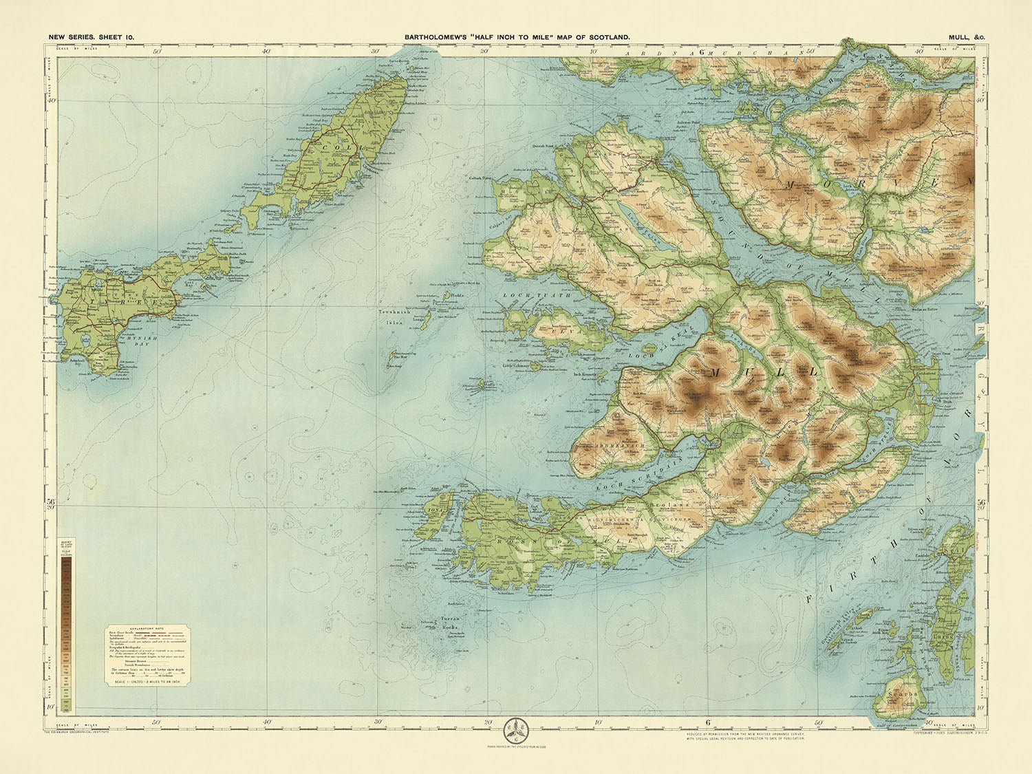


Mappa OS antica di Mull, Argyll di Bartholomew, 1901: Tobermory, Ben More, Castello di Duart, Loch na Keal, Abbazia di Iona, Sound of Mull
L’offerta del Collezionista
Scegli due opere idonee e ricevi il 20% di sconto su entrambe. Scegline tre e quella al prezzo più basso è in omaggio, con un risparmio massimo del 33%.
Abbina liberamente mappe standard idonee e stampe d’arte fine art. Non è richiesto alcun codice; l’offerta viene applicata automaticamente al checkout.
Sono incluse le configurazioni standard su ordinazione. Sono esclusi formati su misura, design personalizzati e lavori su commissione.
Hai bisogno di consegne a indirizzi diversi? Contattaci prima di effettuare l’ordine.L’offerta del Collezionista
Scegli due opere idonee e ricevi il 20% di sconto su entrambe. Scegline tre e quella al prezzo più basso è in omaggio, con un risparmio massimo del 33%.
Abbina liberamente mappe standard idonee e stampe d’arte fine art. Non è richiesto alcun codice; l’offerta viene applicata automaticamente al checkout.
Sono incluse le configurazioni standard su ordinazione. Sono esclusi formati su misura, design personalizzati e lavori su commissione.
Hai bisogno di consegne a indirizzi diversi? Contattaci prima di effettuare l’ordine.
Restaurata dalla mappa originale del 1901 e stampata in qualità museale. Leggi la storia dietro questa mappa
Choose your size
Choose your finish


(Maggiori informazioni)
Gift message & custom finish

If you want to add a gift message, or a finish (jigsaw, aluminium board, etc.) that is not available here, please request it in the "order note" when you check out.
Every order is custom made, so if you need the size adjusted slightly, or printed on an unusual material, just let us know. We've done thousands of custom orders over the years, so there's (almost) nothing we can't manage.
You can also contact us before you order, if you prefer!

- Prodotto localmente. Consegna sicura
- Nessun dazio o costo nascosto
- Serve aiuto? Chiamaci o messaggio su WhatsApp
Own a piece of history
8,000+ five-star reviews


La mappa 10 - Mull, realizzata dal rinomato cartografo JG Bartholomew nel 1901, è un capolavoro della cartografia dei primi del XX...
Continua a leggereLa mappa 10 - Mull, realizzata dal rinomato cartografo JG Bartholomew nel 1901, è un capolavoro della cartografia dei primi del XX secolo. Bartholomew, noto per le sue mappe innovative e di alta qualità, ha creato questa mappa dettagliata in scala di mezza pollice per miglio per soddisfare il crescente interesse per il ciclismo e il turismo. Il titolo originale della mappa riflette il suo focus sull'Isola di Mull e i suoi dintorni, catturando l'essenza di questa regione scozzese aspra e pittoresca.
Il design di questa mappa è particolarmente notevole per l'uso della gradazione dei colori per rappresentare il rilievo del paesaggio. Diversi strati di bande colorate mostrano elegantemente la terra a diverse altezze, fornendo una rappresentazione chiara e visivamente attraente della topografia della regione. Questo approccio innovativo era un marchio distintivo delle mappe di Bartholomew, che le distingueva da altre dell'epoca. L'orientamento paesaggistico della mappa migliora ulteriormente la sua leggibilità e il suo fascino estetico, rendendola un possesso prezioso per collezionisti ed appassionati di cartografia storica.
La mappa di Bartholomew è ricca di dettagli, mostrando i confini politici e le caratteristiche fisiche dell'Isola di Mull e dei suoi dintorni. Mette in evidenza la costa intricata, numerosi laghi come Loch Scridain, Loch na Keal e Loch Buie, e l'imponente montagna Ben More. La mappa cattura anche il Sound of Mull e la Penisola di Ardmeanach, fornendo una vista completa della bellezza naturale della regione. Questo livello di dettaglio non solo aiuta nella navigazione, ma offre anche uno sguardo affascinante sulla geografia della Scozia dei primi del XX secolo.
Oltre alle sue caratteristiche naturali, la mappa segna anche importanti punti di riferimento storici e culturali. Il Castello di Duart, una prominente fortezza sull'Isola di Mull, e l'Abbazia di Iona, un sito di immensa importanza storica e religiosa sull'Isola di Iona, sono entrambi chiaramente indicati. Questi punti di riferimento, insieme alle Isole Treshnish e al Sound di Iona, aggiungono profondità e contesto alla mappa, rendendola una risorsa preziosa per storici e appassionati di cultura.
Le città e i villaggi rappresentati sulla mappa, come Tobermory, Salen, Craignure e Bunessan sull'Isola di Mull, così come Oban e Fort William nelle aree circostanti, offrono un'istantanea della geografia umana dell'epoca. Queste città, ordinate per popolazione moderna, offrono spunti sullo sviluppo della regione e sulla distribuzione dei suoi abitanti. Il dettaglio meticoloso e il contesto storico della mappa la rendono uno strumento indispensabile per chiunque sia interessato al ricco arazzo del passato della Scozia.
Città e paesi su questa mappa
- Isola di Mull:
- Tobermory
- Salen
- Craignure
- Bunessan
- Fionnphort
- Lochdon
- Dervaig
-
Pennyghael
-
Aree circostanti:
- Oban
- Fort William
- Ardgour
- Strontian
- Lochaline
Caratteristiche e punti di riferimento notevoli
- Caratteristiche naturali:
- Loch Scridain
- Loch na Keal
- Loch Buie
- Loch Spelve
- Loch Don
- Loch Aline
- Sound of Mull
- Penisola di Ardmeanach
- Ross di Mull
- Ben More (montagna)
- Sound di Iona
- Loch Sunart
- Isola di Iona
- Isole Treshnish
- Loch Linnhe
- Loch Leven
-
Loch Eil
-
Caratteristiche storiche e culturali:
- Castello di Duart (situato sull'Isola di Mull)
- Abbazia di Iona (situata sull'Isola di Iona)
Contesto storico e di design
- Nome della mappa: Foglio 10 - Mull
- Scala: Mezzo pollice per miglio (1:126,720)
- Data di creazione: 1901
- Cartografo/Editore: JG Bartholomew
- Contesto sul cartografo: John George Bartholomew era un rinomato cartografo e geografo scozzese, noto per le sue mappe innovative e di alta qualità. Le mappe di Bartholomew erano spesso caratterizzate dalla loro chiarezza, precisione e uso del colore per rappresentare il terreno.
- Note aggiuntive:
- Una mappa chiara, attraente e colorata in scala mezzo pollice per miglio (1:126,720).
- Queste mappe erano popolari tra ciclisti e turisti e divennero la serie di punta di Bartholomew.
- Le mappe a mezzo pollice erano distintive per l'uso di diversi strati di colore per rappresentare il rilievo del paesaggio, con una gradazione sottile e innovativa di bande di colore usate per mostrare la terra a diverse altezze.
- La mappa si basa su una mappa dell'Ordnance Survey ridotta dello stesso periodo.
- Design e stile:
- La mappa utilizza un'orientazione paesaggistica.
- Impiega una gradazione di bande di colore per mostrare la terra a diverse altezze, fornendo una chiara rappresentazione visiva del terreno.
- Significato storico:
- La mappa fa parte della serie di punta di Bartholomew, che era molto apprezzata per la sua accuratezza e appeal estetico.
- Riflette l'interesse all'inizio del XX secolo per attività all'aperto come il ciclismo e il turismo.
Si prega di controllare attentamente le immagini per assicurarsi che una città o un luogo specifico sia mostrato su questa mappa. Puoi anche contattarci e chiedere di controllare la mappa per te.
Questa mappa appare fantastica in ogni dimensione, ma consiglio sempre di optare per una dimensione più grande se hai spazio. In questo modo puoi facilmente distinguere tutti i dettagli.
Questa mappa appare incredibile in dimensioni fino a 70in (180cm). Se stai cercando una mappa più grande, per favore contattaci.
Si prega di notare: le etichette su questa mappa sono difficili da leggere se ordini una mappa che è 20in (50cm) o più piccola. La mappa è ancora molto attraente, ma se desideri leggere facilmente la mappa, ti preghiamo di acquistare una dimensione più grande.
Il modello nelle immagini dell'annuncio tiene la versione 18x24in (45x60cm) di questa mappa.
La quinta immagine dell'annuncio mostra un esempio del mio servizio di personalizzazione delle mappe.
Se stai cercando qualcosa di leggermente diverso, dai un'occhiata alla mia collezione delle migliori mappe antiche per vedere se qualcosa colpisce la tua attenzione.
Per favore contattami per controllare se un certo luogo, punto di riferimento o caratteristica è mostrato su questa mappa.
Questa sarebbe una meravigliosa idea regalo per compleanni, Natale, Festa del Papà, pensionamento, anniversario o per una festa di inaugurazione per qualcuno delle aree coperte da questa mappa.
Questa mappa è disponibile come stampa giclée su carta opaca archivistica senza acidi, oppure puoi acquistarla incorniciata. La cornice è una bella e semplice cornice nera che si adatta alla maggior parte degli stili. Ti preghiamo di contattarci se desideri un colore o un materiale diverso per la cornice. Le mie cornici sono dotate di vetro acrilico super chiaro di grado museale (perspex/acrylite), che è significativamente meno riflettente del vetro, più sicuro e arriverà sempre in perfette condizioni.
This map is also available as a float framed canvas, sometimes known as a shadow gap framed canvas or canvas floater. The map is printed on artist's cotton canvas and then stretched over a handmade box frame. We then "float" the canvas inside a wooden frame, which is available in a range of colours (black, dark brown, oak, antique gold and white). This is a wonderful way to present a map without glazing in front. See some examples of float framed canvas maps and explore the differences between my different finishes.
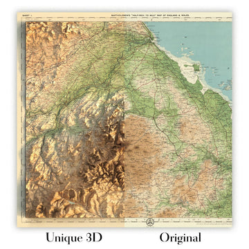
For something truly unique, this map is also available in "Unique 3D", our trademarked process that dramatically transforms the map so that it has a wonderful sense of depth. We combine the original map with detailed topography and elevation data, so that mountains and the terrain really "pop". For more info and examples of 3D maps, check my Unique 3D page.
La mappa 10 - Mull, realizzata dal rinomato cartografo JG Bartholomew nel 1901, è un capolavoro della cartografia dei primi del XX secolo. Bartholomew, noto per le sue mappe innovative e di alta qualità, ha creato questa mappa dettagliata in scala di mezza pollice per miglio per soddisfare il crescente interesse per il ciclismo e il turismo. Il titolo originale della mappa riflette il suo focus sull'Isola di Mull e i suoi dintorni, catturando l'essenza di questa regione scozzese aspra e pittoresca.
Il design di questa mappa è particolarmente notevole per l'uso della gradazione dei colori per rappresentare il rilievo del paesaggio. Diversi strati di bande colorate mostrano elegantemente la terra a diverse altezze, fornendo una rappresentazione chiara e visivamente attraente della topografia della regione. Questo approccio innovativo era un marchio distintivo delle mappe di Bartholomew, che le distingueva da altre dell'epoca. L'orientamento paesaggistico della mappa migliora ulteriormente la sua leggibilità e il suo fascino estetico, rendendola un possesso prezioso per collezionisti ed appassionati di cartografia storica.
La mappa di Bartholomew è ricca di dettagli, mostrando i confini politici e le caratteristiche fisiche dell'Isola di Mull e dei suoi dintorni. Mette in evidenza la costa intricata, numerosi laghi come Loch Scridain, Loch na Keal e Loch Buie, e l'imponente montagna Ben More. La mappa cattura anche il Sound of Mull e la Penisola di Ardmeanach, fornendo una vista completa della bellezza naturale della regione. Questo livello di dettaglio non solo aiuta nella navigazione, ma offre anche uno sguardo affascinante sulla geografia della Scozia dei primi del XX secolo.
Oltre alle sue caratteristiche naturali, la mappa segna anche importanti punti di riferimento storici e culturali. Il Castello di Duart, una prominente fortezza sull'Isola di Mull, e l'Abbazia di Iona, un sito di immensa importanza storica e religiosa sull'Isola di Iona, sono entrambi chiaramente indicati. Questi punti di riferimento, insieme alle Isole Treshnish e al Sound di Iona, aggiungono profondità e contesto alla mappa, rendendola una risorsa preziosa per storici e appassionati di cultura.
Le città e i villaggi rappresentati sulla mappa, come Tobermory, Salen, Craignure e Bunessan sull'Isola di Mull, così come Oban e Fort William nelle aree circostanti, offrono un'istantanea della geografia umana dell'epoca. Queste città, ordinate per popolazione moderna, offrono spunti sullo sviluppo della regione e sulla distribuzione dei suoi abitanti. Il dettaglio meticoloso e il contesto storico della mappa la rendono uno strumento indispensabile per chiunque sia interessato al ricco arazzo del passato della Scozia.
Città e paesi su questa mappa
- Isola di Mull:
- Tobermory
- Salen
- Craignure
- Bunessan
- Fionnphort
- Lochdon
- Dervaig
-
Pennyghael
-
Aree circostanti:
- Oban
- Fort William
- Ardgour
- Strontian
- Lochaline
Caratteristiche e punti di riferimento notevoli
- Caratteristiche naturali:
- Loch Scridain
- Loch na Keal
- Loch Buie
- Loch Spelve
- Loch Don
- Loch Aline
- Sound of Mull
- Penisola di Ardmeanach
- Ross di Mull
- Ben More (montagna)
- Sound di Iona
- Loch Sunart
- Isola di Iona
- Isole Treshnish
- Loch Linnhe
- Loch Leven
-
Loch Eil
-
Caratteristiche storiche e culturali:
- Castello di Duart (situato sull'Isola di Mull)
- Abbazia di Iona (situata sull'Isola di Iona)
Contesto storico e di design
- Nome della mappa: Foglio 10 - Mull
- Scala: Mezzo pollice per miglio (1:126,720)
- Data di creazione: 1901
- Cartografo/Editore: JG Bartholomew
- Contesto sul cartografo: John George Bartholomew era un rinomato cartografo e geografo scozzese, noto per le sue mappe innovative e di alta qualità. Le mappe di Bartholomew erano spesso caratterizzate dalla loro chiarezza, precisione e uso del colore per rappresentare il terreno.
- Note aggiuntive:
- Una mappa chiara, attraente e colorata in scala mezzo pollice per miglio (1:126,720).
- Queste mappe erano popolari tra ciclisti e turisti e divennero la serie di punta di Bartholomew.
- Le mappe a mezzo pollice erano distintive per l'uso di diversi strati di colore per rappresentare il rilievo del paesaggio, con una gradazione sottile e innovativa di bande di colore usate per mostrare la terra a diverse altezze.
- La mappa si basa su una mappa dell'Ordnance Survey ridotta dello stesso periodo.
- Design e stile:
- La mappa utilizza un'orientazione paesaggistica.
- Impiega una gradazione di bande di colore per mostrare la terra a diverse altezze, fornendo una chiara rappresentazione visiva del terreno.
- Significato storico:
- La mappa fa parte della serie di punta di Bartholomew, che era molto apprezzata per la sua accuratezza e appeal estetico.
- Riflette l'interesse all'inizio del XX secolo per attività all'aperto come il ciclismo e il turismo.
Si prega di controllare attentamente le immagini per assicurarsi che una città o un luogo specifico sia mostrato su questa mappa. Puoi anche contattarci e chiedere di controllare la mappa per te.
Questa mappa appare fantastica in ogni dimensione, ma consiglio sempre di optare per una dimensione più grande se hai spazio. In questo modo puoi facilmente distinguere tutti i dettagli.
Questa mappa appare incredibile in dimensioni fino a 70in (180cm). Se stai cercando una mappa più grande, per favore contattaci.
Si prega di notare: le etichette su questa mappa sono difficili da leggere se ordini una mappa che è 20in (50cm) o più piccola. La mappa è ancora molto attraente, ma se desideri leggere facilmente la mappa, ti preghiamo di acquistare una dimensione più grande.
Il modello nelle immagini dell'annuncio tiene la versione 18x24in (45x60cm) di questa mappa.
La quinta immagine dell'annuncio mostra un esempio del mio servizio di personalizzazione delle mappe.
Se stai cercando qualcosa di leggermente diverso, dai un'occhiata alla mia collezione delle migliori mappe antiche per vedere se qualcosa colpisce la tua attenzione.
Per favore contattami per controllare se un certo luogo, punto di riferimento o caratteristica è mostrato su questa mappa.
Questa sarebbe una meravigliosa idea regalo per compleanni, Natale, Festa del Papà, pensionamento, anniversario o per una festa di inaugurazione per qualcuno delle aree coperte da questa mappa.
Questa mappa è disponibile come stampa giclée su carta opaca archivistica senza acidi, oppure puoi acquistarla incorniciata. La cornice è una bella e semplice cornice nera che si adatta alla maggior parte degli stili. Ti preghiamo di contattarci se desideri un colore o un materiale diverso per la cornice. Le mie cornici sono dotate di vetro acrilico super chiaro di grado museale (perspex/acrylite), che è significativamente meno riflettente del vetro, più sicuro e arriverà sempre in perfette condizioni.
This map is also available as a float framed canvas, sometimes known as a shadow gap framed canvas or canvas floater. The map is printed on artist's cotton canvas and then stretched over a handmade box frame. We then "float" the canvas inside a wooden frame, which is available in a range of colours (black, dark brown, oak, antique gold and white). This is a wonderful way to present a map without glazing in front. See some examples of float framed canvas maps and explore the differences between my different finishes.
For something truly unique, this map is also available in "Unique 3D", our trademarked process that dramatically transforms the map so that it has a wonderful sense of depth. We combine the original map with detailed topography and elevation data, so that mountains and the terrain really "pop". For more info and examples of 3D maps, check my Unique 3D page.
Many of our maps and art prints are chosen as thoughtful gifts for homes, offices, studies and meaningful places.
Choose a framed option for the easiest ready-to-hang gift, or choose an unframed print if the recipient may prefer to select their own frame.
We make orders locally in 23 countries around the world, so gifts can often be produced close to the recipient. This helps them arrive faster, travel more safely, and avoid customs or import duty surprises.
- We can deliver directly to the recipient
- Framed pieces arrive ready to hang
- Unframed prints are carefully packed in a strong protective tube
- Almost every order is made locally, for faster, safer gifting
- 90-day returns give the recipient time to decide
If you are not sure what to choose, please contact us. We can help you pick the right map, size, finish or delivery option.
Most orders are made locally and delivered in around 2–3 working days, depending on the product, size and destination.
We print and frame maps and artwork in 23 countries around the world, so your order is usually made close to you or your recipient. That means faster delivery, less time in transit, and no customs or import duty surprises.
Personalised and customised pieces usually take an extra 1–2 working days, because we prepare your design and send it to you for approval before printing.
Very large framed orders can take a little longer, as they need extra care in production and delivery.
Every order is carefully packaged: unframed prints are sent in a strong protective tube, while framed pieces are securely packed with protective materials around the frame.
If you need your order by a particular date, please contact us before ordering. We’ll check the best production route and delivery option for your location.
Express delivery is available at checkout for most countries. Next-day delivery is available in the UK, US, Singapore and the UAE.
Your order is covered by our 90-day returns policy and 10-year guarantee.
Our standard frame is a gallery-style black ash hardwood frame, with a simple, modern look. It is approximately 20mm (0.8in) wide. You can also view some lovely customer photos of framed maps and art.
We use super-clear acrylic glazing, also known as Perspex or Acrylite, instead of traditional glass. It is lighter, safer, and has lower reflectivity, giving the artwork a clearer, cleaner appearance.
Six standard frame colours are available at no extra cost: black, dark brown, dark grey, oak, white, and antique gold. Custom framing and mounting/matting is also available for customers looking for something more specific.
Most maps, art prints, and illustrations are also available as a framed canvas. We use matte cotton canvas, stretch it over a sustainably sourced wooden box frame, and then float the piece within a wooden outer frame. The finished result is beautifully presented, with no glazing between you and the artwork.
All frames are supplied ready to hang, with either string or brackets fitted to the back. Very large frames will include heavy-duty hanging plates and/or a mounting baton. If you have any questions, please get in touch.
We can also supply old maps and artwork on canvas, foam board, cotton rag, and other materials.
If you would prefer to frame your map or artwork yourself, please read our size guide before ordering.
My maps are extremely high quality reproductions of original maps.
I source original, rare maps from libraries, auction houses and private collections around the world, restore them at my London workshop, and then use specialist giclée inks and printers to create beautiful maps that look even better than the original.
My maps are printed on acid-free archival matte (not glossy) paper that feels very high quality and almost like card. In technical terms the paper weight/thickness is 10mil/200gsm. It's perfect for framing.
I print with Epson ultrachrome giclée UV fade resistant pigment inks - some of the best inks you can find.
I can also make maps on canvas, cotton rag and other exotic materials.
Learn more about The Unique Maps Co.
Map personalisation
If you're looking for the perfect anniversary or housewarming gift, I can personalise your map to make it truly unique. For example, I can add a short message, or highlight an important location, or add your family's coat of arms.
The options are almost infinite. Please see my map personalisation page for some wonderful examples of what's possible.
To order a personalised map, select "personalise your map" before adding it to your basket.
Get in touch if you're looking for more complex customisations and personalisations.
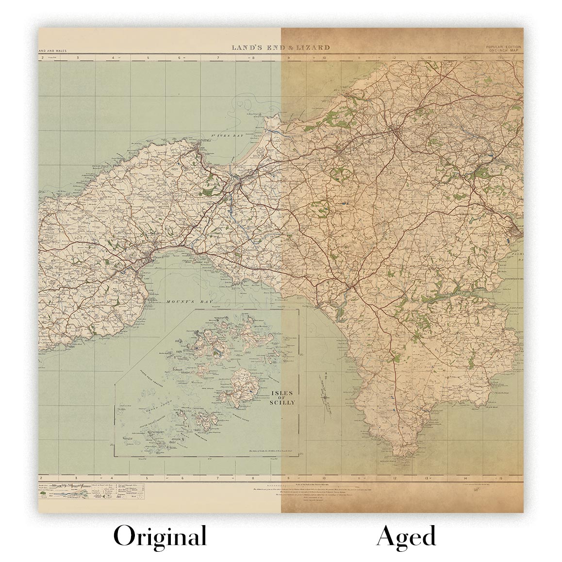
Map ageing
I have been asked hundreds of times over the years by customers if they could buy a map that looks even older.
Well, now you can, by selecting Aged before you add a map to your basket.
All the product photos you see on this page show the map in its Original form. This is what the map looks like today.
If you select Aged, I will age your map by hand, using a special and unique process developed through years of studying old maps, talking to researchers to understand the chemistry of aging paper, and of course... lots of practice!
If you're unsure, stick to the Original colour of the map. If you want something a bit darker and older looking, go for Aged.
Se non sei soddisfatto del tuo ordine per qualsiasi motivo, contattami per un rimborso senza problemi. Si prega di consultare la nostra politica di reso e rimborso per ulteriori informazioni.
Sono molto sicuro che ti piacerà la tua mappa restaurata o la stampa d'arte. Lo faccio dal 1984. Sono un venditore Etsy a 5 stelle. Ho venduto decine di migliaia di mappe e stampe d'arte e ho oltre 5.000 recensioni reali a 5 stelle.
Utilizzo un processo unico per restaurare mappe e opere d'arte che richiede molto tempo e lavoro. Trovare le mappe e le illustrazioni originali può richiedere mesi. Utilizzo tecnologia all'avanguardia e incredibilmente costosa per scannerizzare e restaurarle. Di conseguenza, garantisco che le mie mappe e stampe d'arte siano superiori alle altre - ecco perché posso offrire un rimborso senza problemi.
Quasi tutte le mie mappe e stampe d'arte sembrano fantastiche a grandi dimensioni (200 cm, 6,5 piedi+) e posso anche incorniciarle e consegnarle a te, tramite un corriere speciale per oggetti di grandi dimensioni. Contattami per discutere delle tue esigenze specifiche.
Or try searching for something!


