

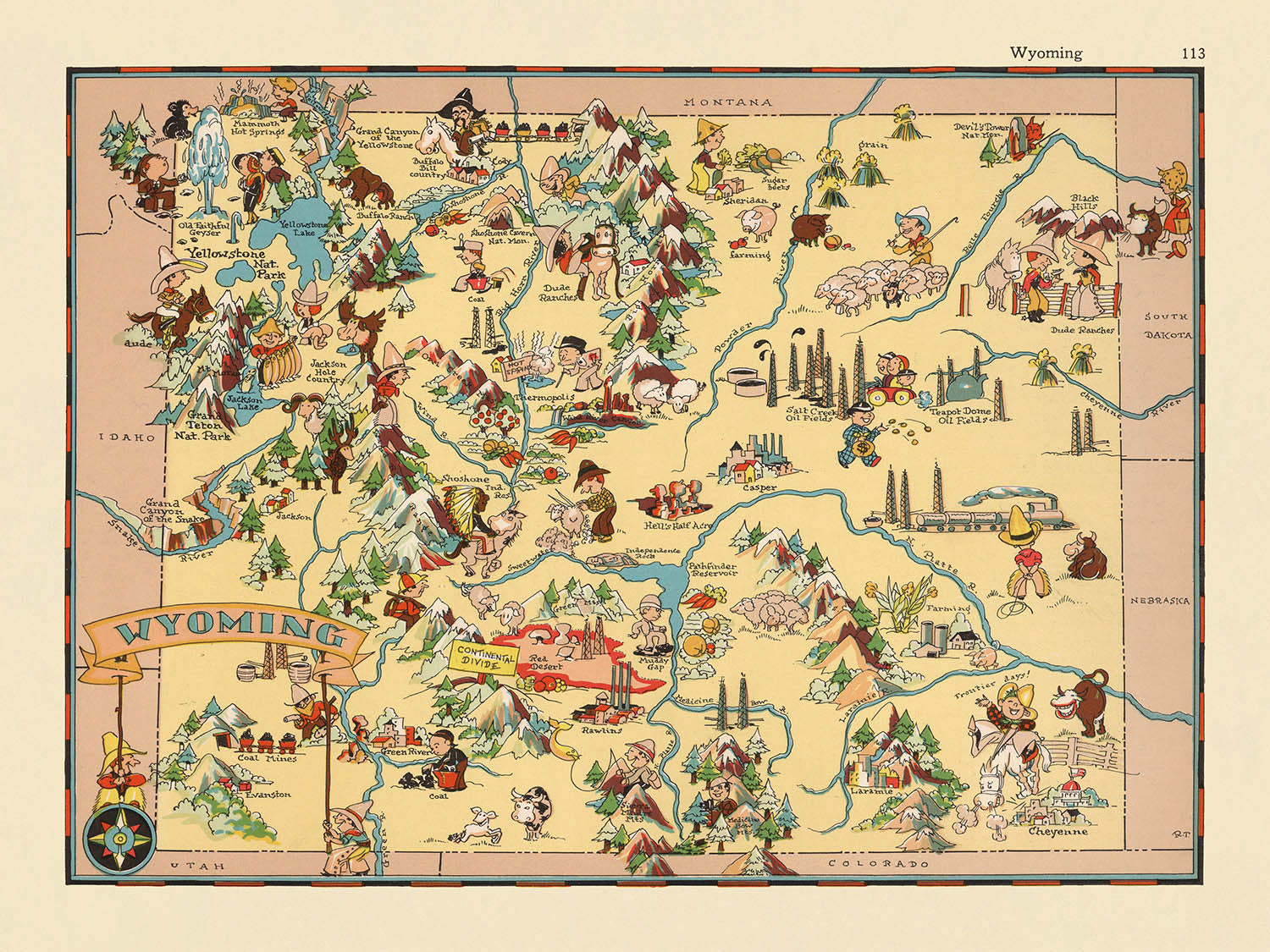


Mappa pittorica del Wyoming di Ruth Taylor White, 1935: Yellowstone, Grand Teton, Continental Divide, Wind River Range, Monti Bighorn
20% di sconto su 2 — 33% di sconto su 3
Aggiungi qualsiasi due articoli idonei al tuo carrello per ricevere 20% di sconto. Aggiungi un terzo e sarà gratuito (equivalente a 33% di sconto quando acquisti tre).
Nessun codice necessario — l'offerta si applica automaticamente al checkout.
Valido su tutte le mappe standard e le stampe d'arte fine. Puoi mescolare e abbinare qualsiasi design.
Se desideri spedire articoli a più indirizzi, ti preghiamo di contattarci prima di effettuare il tuo ordine.
Le commissioni personalizzate e su misura sono escluse.
Contattaci se hai domande

Choose your size
Choose your finish


(Maggiori informazioni)
Gift message & custom finish

If you want to add a gift message, or a finish (jigsaw, aluminium board, etc.) that is not available here, please request it in the "order note" when you check out.
Every order is custom made, so if you need the size adjusted slightly, or printed on an unusual material, just let us know. We've done thousands of custom orders over the years, so there's (almost) nothing we can't manage.
You can also contact us before you order, if you prefer!

- Made locally for fast, safe delivery
- No import duty or hidden fees
- Need advice? Message us on WhatsApp
Own a piece of history
7,000+ 5 star reviews


Entra nel vibrante mondo dell'America degli anni '30 con "Wyoming," una mappa pittorica affascinante originariamente realizzata dalla celebre cartografa Ruth Taylor White nel 1935. Quest'opera unica rappresenta un testamento sia all'arte che allo spirito della sua epoca, attirando gli spettatori in una visione fantasiosa, ma ricca di informazioni, dello Stato dell'uguaglianza. L'approccio di Taylor White alla cartografia era tutt'altro che convenzionale: le sue mappe esplodono di colore e illustrazioni giocose, mescolando fatti storici con la vivace immaginazione del periodo tra le due guerre. Ogni elemento di questa mappa, dal suo titolo audace ai suoi confini disegnati a mano, è infuso di un senso di scoperta e gioia, invitando collezionisti ed appassionati di storia a vivere il Wyoming come lo vedeva una generazione passata.
Ruth Taylor White, rinomata per la sua serie di atlanti pittorici, ha trasformato il modo in cui gli americani si relazionavano con la geografia. Le sue mappe, inclusa questa straordinaria rappresentazione del Wyoming, erano progettate non solo per informare ma anche per intrattenere. Il lavoro di Taylor White si distingue per la sua fusione di contenuti educativi e narrazione visiva, un mix che riflette sia il suo talento artistico che la sua acuta comprensione del contesto culturale. Attraverso i suoi occhi, le vaste distese del Wyoming diventano un palcoscenico per cowboys, figure dei nativi americani e una fauna selvatica abbondante, ognuna rappresentata in uno stile che è al contempo affascinante ed evocativo degli anni '30. Le sue mappe rimangono artefatti ricercati, apprezzati per la loro risonanza storica e il loro duraturo fascino estetico.
Il design della mappa è una festa per i sensi, con ogni angolo brulicante di vivaci vignette e simboli accuratamente scelti. I principali punti di riferimento naturali sono illustrati in dettagli vividi: il Parco Nazionale di Yellowstone, con le sue meraviglie geotermiche, cattura l'attenzione a nord-ovest, mentre le imponenti vette del Parco Nazionale di Grand Teton si ergono maestose appena a sud. Il possente Continental Divide taglia un percorso drammatico attraverso lo stato, affiancato dalla Wind River Range e dalle Bighorn Mountains. Fiumi come il Snake e il Platte si snodano attraverso il paesaggio, ancorando il senso di luogo della mappa e rispecchiando i ritmi del mondo naturale del Wyoming.
Oltre alla sua celebrazione della geografia, la mappa offre una finestra affascinante sulla vita culturale ed economica dello stato durante l'inizio del ventesimo secolo. L'allevamento, una pietra angolare dell'identità del Wyoming, è rappresentato attraverso scene animate di cowboys e mandrie di bestiame, mentre l'estrazione mineraria e petrolifera sono riconosciute con illustrazioni sottili ma significative. La Oregon Trail è segnata come un filo di migrazione e ambizione americana, e l'iconico Devils Tower sorge come un testamento alla geologia unica dello stato. Sorgenti termali, antilopi e bisonti popolano il terreno, ciascuno contribuendo a una narrazione che è sia specifica per la regione che universalmente coinvolgente.
Un tour degli insediamenti della mappa rivela un arazzo delle comunità del Wyoming, dalla vivace capitale di Cheyenne alla cittadina montana di Jackson. Ogni città e paese è posizionato meticolosamente, riflettendo i diversi centri di popolazione dello stato e i loro ruoli nel plasmare la storia del Wyoming. Questa attenta attenzione ai dettagli, unita allo stile esuberante della mappa, assicura che ogni visione porti a nuove scoperte. Che tu sia un collezionista esperto, un amante della storia americana o semplicemente affascinato dal fascino del West, questa mappa è un invito a esplorare, apprendere e meravigliarsi dell'eredità duratura del genio cartografico di Ruth Taylor White.
Città e paesi su questa mappa
- Cheyenne
- Casper
- Laramie
- Gillette
- Rock Springs
- Sheridan
- Green River
- Evanston
- Riverton
- Cody
- Rawlins
- Lander
- Jackson
- Powell
- Torrington
- Douglas
- Worland
- Buffalo
- Wheatland
- Newcastle
- Thermopolis
- Glenrock
- Lovell
- Kemmerer
- Pinedale
- Sundance
- Basin
- Greybull
- Saratoga
- Guernsey
- Shoshoni
Caratteristiche e Luoghi di Interesse
- Il Parco Nazionale di Yellowstone è illustrato e etichettato nell'angolo nord-ovest dello stato.
- Il Parco Nazionale di Grand Teton è rappresentato e etichettato appena a sud di Yellowstone.
- Il Continente Divide è illustrato e etichettato, attraversando lo stato.
- La Catena Montuosa del Wind River è illustrata e etichettata.
- Le Montagne Bighorn sono illustrate e etichettate.
- Il Fiume Snake è illustrato e etichettato.
- Il Fiume Platte è illustrato e etichettato.
- La mappa presenta illustrazioni di cowboy e bestiame, enfatizzando l'eredità agricola del Wyoming.
- Figure e motivi dei Nativi Americani sono illustrati, riflettendo la storia indigena della regione.
- Presenti illustrazioni di fauna selvatica, come bisonti e antilopi.
- La mappa include riferimenti visivi all'estrazione mineraria e petrolifera, indicando l'importanza delle risorse naturali nell'economia del Wyoming.
- Il Sentiero dell'Oregon è illustrato e etichettato, facendo riferimento al percorso migratorio storico.
- Il Devils Tower è illustrato e etichettato come un luogo di interesse notevole.
- Le Acque Termali sono illustrate e etichettate, facendo riferimento alle caratteristiche geotermiche dello stato.
Contesto storico e di design
- Nome della mappa: Wyoming.
- Data di creazione: 1935.
- Cartografo: Ruth Taylor White.
- La mappa utilizza illustrazioni vivaci e simili a cartoni animati, caratteristiche delle mappe pittoriche degli anni '30, per rappresentare temi culturali, economici e storici.
- La mappa mette in evidenza scene e attività stereotipate associate al Wyoming all'inizio del XX secolo, come l'allevamento, la cultura dei Nativi Americani e i paesaggi naturali.
- È rappresentato l'intero stato del Wyoming, USA.
- La mappa è parte di una serie più ampia che mirava a rendere la geografia e la storia statale accessibili e divertenti attraverso la narrazione visiva.
- La mappa riflette sia la cultura popolare che gli atteggiamenti sociali degli anni '30, inclusi stereotipi e immagini specifiche del periodo.
- Funziona come un artefatto storico, illustrando come il Wyoming fosse percepito e rappresentato all'inizio del XX secolo.
- Offre un'idea dell'identità e dell'economia del Wyoming dell'epoca, con enfasi sull'allevamento, le risorse naturali e il turismo.
- La mappa è riccamente colorata e piena di illustrazioni bizzarre, rendendola sia informativa che decorativa.
- Nota per la sua fusione di arte e informazione, rendendola un esempio unico di cartografia pittorica americana del periodo tra le due guerre.
Si prega di controllare attentamente le immagini per assicurarsi che una specifica città o luogo sia mostrato su questa mappa. Puoi anche contattarci e chiedere di controllare la mappa per te.
Questa mappa appare fantastica in ogni dimensione, ma consiglio sempre di optare per una dimensione più grande se hai spazio. In questo modo puoi facilmente distinguere tutti i dettagli.
Questa mappa sembra fantastica in dimensioni fino a 50 pollici (125 cm). Se stai cercando una mappa più grande, per favore contattaci.
Il modello nelle immagini dell'annuncio sta tenendo la versione 18x24 pollici (45x60 cm) di questa mappa.
La quinta immagine dell'annuncio mostra un esempio del mio servizio di personalizzazione della mappa.
Se stai cercando qualcosa di leggermente diverso, dai un'occhiata alla mia collezione delle migliori vecchie mappe per vedere se qualcosa attira la tua attenzione.
Per favore contattami per verificare se una certa posizione, punto di riferimento o caratteristica è mostrata su questa mappa.
Questa sarebbe un'ottima idea regalo per un compleanno, Natale, Festa del Papà, addio al lavoro, anniversario o inaugurazione della casa per qualcuno delle aree coperte da questa mappa.
Questa mappa è disponibile come stampa giclée su carta opaca archiviata senza acidi, oppure puoi acquistarla incorniciata. La cornice è una semplice cornice nera che si adatta alla maggior parte degli stili. Per favore contattami se desideri un colore o materiale della cornice diverso. Le mie cornici sono dotate di un vetro acrilico (perspex/acrylite) super chiaro di qualità museale, che è significativamente meno riflettente del vetro, più sicuro e arriverà sempre in perfette condizioni.
This map is also available as a float framed canvas, sometimes known as a shadow gap framed canvas or canvas floater. The map is printed on artist's cotton canvas and then stretched over a handmade box frame. We then "float" the canvas inside a wooden frame, which is available in a range of colours (black, dark brown, oak, antique gold and white). This is a wonderful way to present a map without glazing in front. See some examples of float framed canvas maps and explore the differences between my different finishes.
For something truly unique, this map is also available in "Unique 3D", our trademarked process that dramatically transforms the map so that it has a wonderful sense of depth. We combine the original map with detailed topography and elevation data, so that mountains and the terrain really "pop". For more info and examples of 3D maps, check my Unique 3D page.
Many of our maps and art prints are chosen as thoughtful gifts for homes, offices, studies and meaningful places.
Choose a framed option for the easiest ready-to-hang gift, or choose an unframed print if the recipient may prefer to select their own frame.
We make orders locally in 23 countries around the world, so gifts can often be produced close to the recipient. This helps them arrive faster, travel more safely, and avoid customs or import duty surprises.
- We can deliver directly to the recipient
- Framed pieces arrive ready to hang
- Unframed prints are carefully packed in a strong protective tube
- Almost every order is made locally, for faster, safer gifting
- 90-day returns give the recipient time to decide
If you are not sure what to choose, please contact us. We can help you pick the right map, size, finish or delivery option.
Most orders are made locally and delivered in around 2–3 working days, depending on the product, size and destination.
We print and frame maps and artwork in 23 countries around the world, so your order is usually made close to you or your recipient. That means faster delivery, less time in transit, and no customs or import duty surprises.
Personalised and customised pieces usually take an extra 1–2 working days, because we prepare your design and send it to you for approval before printing.
Very large framed orders can take a little longer, as they need extra care in production and delivery.
Every order is carefully packaged: unframed prints are sent in a strong protective tube, while framed pieces are securely packed with protective materials around the frame.
If you need your order by a particular date, please contact us before ordering. We’ll check the best production route and delivery option for your location.
Express delivery is available at checkout for most countries. Next-day delivery is available in the UK, US, Singapore and the UAE.
Your order is covered by our 90-day returns policy and 10-year guarantee.
Our standard frame is a gallery-style black ash hardwood frame, with a simple, modern look. It is approximately 20mm (0.8in) wide. You can also view some lovely customer photos of framed maps and art.
We use super-clear acrylic glazing, also known as Perspex or Acrylite, instead of traditional glass. It is lighter, safer, and has lower reflectivity, giving the artwork a clearer, cleaner appearance.
Six standard frame colours are available at no extra cost: black, dark brown, dark grey, oak, white, and antique gold. Custom framing and mounting/matting is also available for customers looking for something more specific.
Most maps, art prints, and illustrations are also available as a framed canvas. We use matte cotton canvas, stretch it over a sustainably sourced wooden box frame, and then float the piece within a wooden outer frame. The finished result is beautifully presented, with no glazing between you and the artwork.
All frames are supplied ready to hang, with either string or brackets fitted to the back. Very large frames will include heavy-duty hanging plates and/or a mounting baton. If you have any questions, please get in touch.
We can also supply old maps and artwork on canvas, foam board, cotton rag, and other materials.
If you would prefer to frame your map or artwork yourself, please read our size guide before ordering.
My maps are extremely high quality reproductions of original maps.
I source original, rare maps from libraries, auction houses and private collections around the world, restore them at my London workshop, and then use specialist giclée inks and printers to create beautiful maps that look even better than the original.
My maps are printed on acid-free archival matte (not glossy) paper that feels very high quality and almost like card. In technical terms the paper weight/thickness is 10mil/200gsm. It's perfect for framing.
I print with Epson ultrachrome giclée UV fade resistant pigment inks - some of the best inks you can find.
I can also make maps on canvas, cotton rag and other exotic materials.
Learn more about The Unique Maps Co.
Map personalisation
If you're looking for the perfect anniversary or housewarming gift, I can personalise your map to make it truly unique. For example, I can add a short message, or highlight an important location, or add your family's coat of arms.
The options are almost infinite. Please see my map personalisation page for some wonderful examples of what's possible.
To order a personalised map, select "personalise your map" before adding it to your basket.
Get in touch if you're looking for more complex customisations and personalisations.
Map ageing
I have been asked hundreds of times over the years by customers if they could buy a map that looks even older.
Well, now you can, by selecting Aged before you add a map to your basket.
All the product photos you see on this page show the map in its Original form. This is what the map looks like today.
If you select Aged, I will age your map by hand, using a special and unique process developed through years of studying old maps, talking to researchers to understand the chemistry of aging paper, and of course... lots of practice!
If you're unsure, stick to the Original colour of the map. If you want something a bit darker and older looking, go for Aged.
Se non sei soddisfatto del tuo ordine per qualsiasi motivo, contattami per un rimborso senza problemi. Si prega di consultare la nostra politica di reso e rimborso per ulteriori informazioni.
Sono molto sicuro che ti piacerà la tua mappa restaurata o la stampa d'arte. Lo faccio dal 1984. Sono un venditore Etsy a 5 stelle. Ho venduto decine di migliaia di mappe e stampe d'arte e ho oltre 5.000 recensioni reali a 5 stelle.
Utilizzo un processo unico per restaurare mappe e opere d'arte che richiede molto tempo e lavoro. Trovare le mappe e le illustrazioni originali può richiedere mesi. Utilizzo tecnologia all'avanguardia e incredibilmente costosa per scannerizzare e restaurarle. Di conseguenza, garantisco che le mie mappe e stampe d'arte siano superiori alle altre - ecco perché posso offrire un rimborso senza problemi.
Quasi tutte le mie mappe e stampe d'arte sembrano fantastiche a grandi dimensioni (200 cm, 6,5 piedi+) e posso anche incorniciarle e consegnarle a te, tramite un corriere speciale per oggetti di grandi dimensioni. Contattami per discutere delle tue esigenze specifiche.
Or try searching for something!


