


Antica carta nautica dello Stretto di Magellano di Dudley, 1646: Terra del Fuoco, Stretto di Le Maire, Terra Australis
20% di sconto su 2 — 33% di sconto su 3
Aggiungi qualsiasi due articoli idonei al tuo carrello per ricevere 20% di sconto. Aggiungi un terzo e sarà gratuito (equivalente a 33% di sconto quando acquisti tre).
Nessun codice necessario — l'offerta si applica automaticamente al checkout.
Valido su tutte le mappe standard e le stampe d'arte fine. Puoi mescolare e abbinare qualsiasi design.
Se desideri spedire articoli a più indirizzi, ti preghiamo di contattarci prima di effettuare il tuo ordine.
Le commissioni personalizzate e su misura sono escluse.
Contattaci se hai domande

Choose your size
Choose your finish


(Maggiori informazioni)
Gift message & custom finish

If you want to add a gift message, or a finish (jigsaw, aluminium board, etc.) that is not available here, please request it in the "order note" when you check out.
Every order is custom made, so if you need the size adjusted slightly, or printed on an unusual material, just let us know. We've done thousands of custom orders over the years, so there's (almost) nothing we can't manage.
You can also contact us before you order, if you prefer!

- Made locally for fast, safe delivery
- No import duty or hidden fees
- Need advice? Message us on WhatsApp
Own a piece of history
7,000+ 5 star reviews


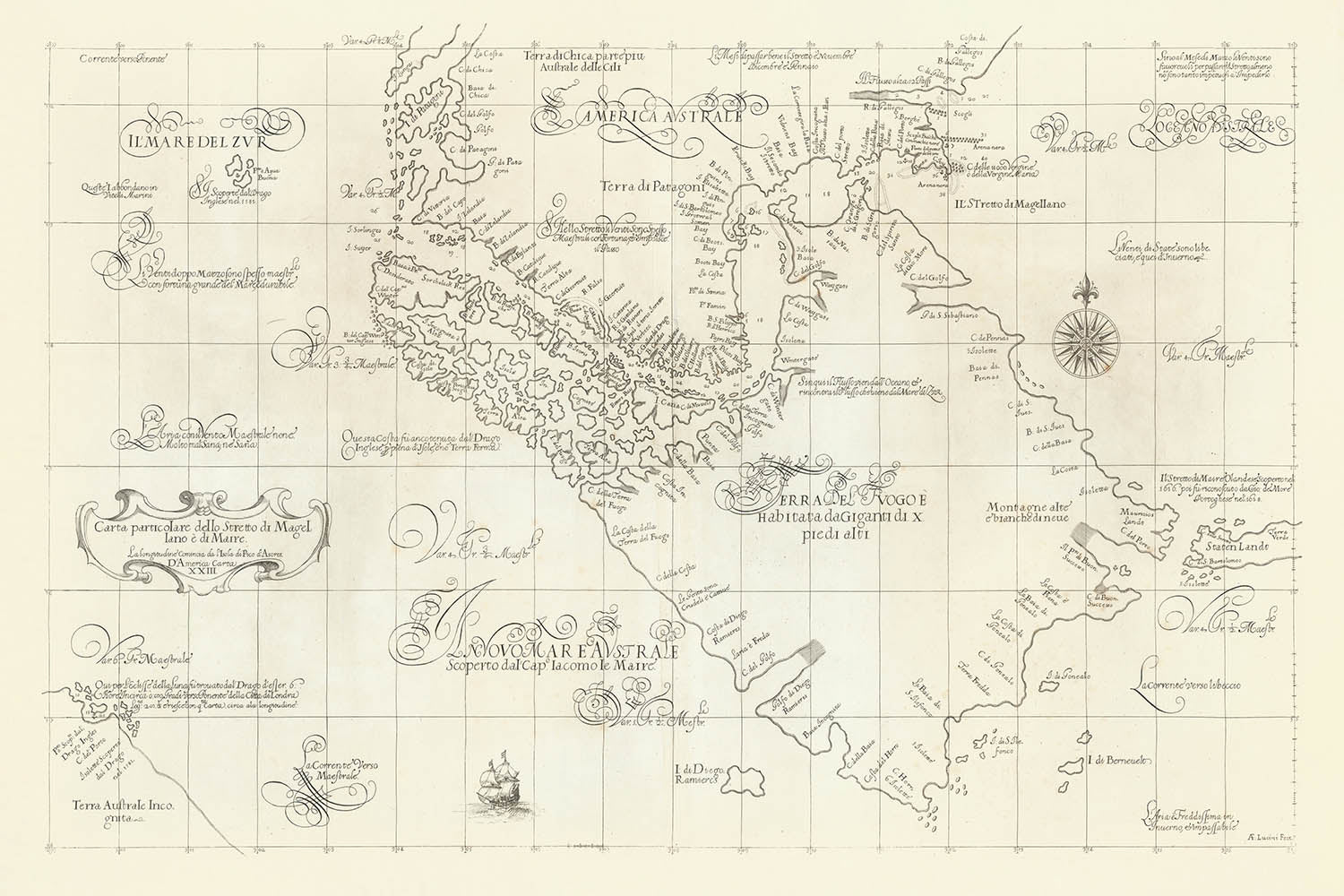
Entra nell'Età delle Scoperte con l'eccellente carta nautica di Robert Dudley del 1646, la "Carta Particolare dello Stretto di Magellano e di Maire." Questa mappa straordinaria cattura le drammatiche vie d'acqua all'estremità meridionale del Sud America, incluso il leggendario Stretto di Magellano e il recentemente scoperto Stretto di Le Maire. La carta di Dudley è una testimonianza della ricerca incessante di conoscenza marittima dell'epoca, offrendo una finestra sulle ambizioni strategiche e lo spirito avventuroso che ha definito l'esplorazione del XVII secolo. Il focus principale della mappa è sulla navigazione, tracciando passaggi pericolosi che erano vitali per il commercio globale e la competizione imperiale.
Ciò che distingue questa carta è la sua maestria nell'unire arte e utilità. Lo stile elegante di Dudley è evidente nei contorni costieri precisi, nelle rose dei venti decorative e nella cura con cui sono posizionati i fondali—numeri che indicano le profondità dell'acqua in braccia—lungo gli stretti e le coste. Le secche, i canali d'acqua e gli ancoraggi sono meticolosamente delineati, fornendo indicazioni essenziali per i marinai. Queste infografiche, rare per il loro tempo, riflettono l'impegno di Dudley per l'accuratezza e le esigenze pratiche dei marinai, elevando la mappa da una semplice illustrazione a uno strumento di navigazione sofisticato.
La carta di Dudley è anche un ricco arazzo della conoscenza geografica e delle speculazioni dell'epoca. La Terra del Fuoco domina la mappa come una vasta isola, circondata da una costellazione di isole più piccole, molte etichettate come sconosciute—un accenno ai misteri che avvolgevano ancora la regione. I nomi dei luoghi circondano le masse terrestri, provenienti dai viaggi pionieristici degli esploratori olandesi Le Maire e Schouten, così come dalle spedizioni spagnole inviate in risposta alle scoperte olandesi. Queste annotazioni offrono uno sguardo affascinante sul trasferimento di conoscenza tra le potenze europee rivali e sulla comprensione in evoluzione delle frontiere più meridionali del mondo.
Aggiungendo all'intrigo, la mappa conserva i miti e le leggende che colorarono le prime esplorazioni. Una nota che fa riferimento ai presunti giganti della Patagonia, una storia nata dal primo viaggio di circumnavigazione di Magellano, accenna alla fusione di fatti e folklore che accompagnarono questi viaggi pericolosi. Nell'angolo in basso a sinistra, Dudley include l'elusivo Continente Meridionale, o Terra Australis, basato su racconti di Sir Francis Drake—che Dudley conosceva personalmente. Questa massa terrestre speculativa sottolinea il senso di meraviglia dell'epoca e la persistente convinzione in mondi non scoperti oltre i mari conosciuti.
Il significato storico di questa mappa è profondo. Essendo una delle prime e più dettagliate carte nautiche della regione, riflette l'intenso interesse europeo nel controllare l'accesso al Pacifico e lo spirito competitivo degli imperi marittimi. Le connessioni di Dudley con esploratori leggendari e le sue innovative tecniche cartografiche rendono questa carta non solo un'opera d'arte bellissima, ma anche un documento vitale della curiosità e dell'ambizione umana. Per collezionisti e intenditori, offre un'opportunità rara di possedere un pezzo della storia avventurosa, enigmatica e in continua evoluzione dell'esplorazione globale.
Luoghi notevoli su questa mappa
- Lo Stretto di Magellano (Stretto di Magellano), il principale canale di navigazione tra gli oceani Atlantico e Pacifico.
- Lo Stretto di Le Maire (Stretto di Maire), un passaggio secondario a est della Terra del Fuoco.
- La Terra del Fuoco (Terra del Fuoco), la grande isola a sud della terraferma sudamericana.
- Isla de los Estados (Staten Island), situata a est della Terra del Fuoco.
- Cape Horn (Cabo Hornos), il capo più meridionale dell'arcipelago, sebbene non sempre etichettato in modo distintivo sulle mappe antiche.
- Vari piccoli isolotti e rocce lungo la costa meridionale della Terra del Fuoco, molti contrassegnati come sconosciuti.
- Porti e ancoraggi noti lungo i passi, etichettati per uso nautico.
- La punta meridionale della terraferma sudamericana, a nord dei passi.
- Massa terrestre speculativa del Continente Meridionale (Terra Australis), come riferito da Drake.
- Caratteristiche costiere come baie, insenature e promontori, etichettate con nomi provenienti da viaggi contemporanei.
Caratteristiche e punti di riferimento notevoli
- Contorni costieri dettagliati e informazioni nautiche per lo Stretto di Magellano e lo Stretto di Le Maire.
- Sonar (profondità dell'acqua in bracci) contrassegnati in tutto lo stretto e nelle aree costiere.
- Rosa dei venti per la navigazione, che indica le direzioni e possibilmente la declinazione magnetica.
- Barriere di sabbia e canali d'acqua delineati, che aiutano i marinai a passare in sicurezza.
- Nomina dei luoghi che circondano la Terra del Fuoco, derivata da spedizioni olandesi e spagnole.
- Note o leggende che fanno riferimento al mito dei giganti, una credenza comune tra i primi esploratori europei.
- Istruzioni di navigazione e annotazioni sui migliori tempi per navigare attraverso i passi.
- Elementi decorativi caratteristici dello stile cartografico elegante di Dudley.
Contesto storico e di design
- Creato nel 1646 da Robert Dudley, un esploratore inglese, cartografo e ingegnere navale noto per il suo influente atlante marittimo, Arcano del Mare.
- Una delle prime e più dettagliate carte nautiche della regione, che riflette conoscenze e speculazioni aggiornate.
- Incorpora dati da spedizioni olandesi e spagnole (Le Maire, Schouten, fratelli Nodales) ed esploratori inglesi (Drake, Cavendish).
- Si concentra sulla navigazione, tracciando passaggi pericolosi che erano vitali per il commercio globale e la competizione imperiale.
- Unisce arte e utilità, con contorni costieri precisi, ausili navigazionali e rose dei venti decorative.
- Riflette l'intenso interesse europeo nel controllare l'accesso al Pacifico e lo spirito competitivo degli imperi marittimi.
- Preserva miti e leggende delle prime esplorazioni, come i presunti giganti della Patagonia e il misterioso Continente Meridionale.
- Fornisce uno sguardo raro e prezioso sulla storia avventurosa, enigmatica e in continua evoluzione dell'esplorazione globale.
Si prega di controllare attentamente le immagini per assicurarsi che una specifica città o luogo sia mostrato su questa mappa. Puoi anche contattarci e chiedere di controllare la mappa per te.
Questa mappa appare fantastica in tutte le dimensioni, ma consiglio sempre di optare per una dimensione più grande se hai spazio. In questo modo puoi facilmente distinguere tutti i dettagli.
Questa mappa appare incredibile in dimensioni fino a 100in (250cm). Se stai cercando una mappa più grande, per favore contattaci.
Il modello nelle immagini dell'elenco tiene la versione 24x36in (60x90cm) di questa mappa.
La quinta immagine dell'elenco mostra un esempio del mio servizio di personalizzazione della mappa.
Se stai cercando qualcosa di leggermente diverso, dai un'occhiata alla mia collezione delle migliori mappe antiche per vedere se qualcosa attira la tua attenzione.
Per favore contattami per verificare se una certa località, punto di riferimento o caratteristica è mostrata su questa mappa.
Questo sarebbe un meraviglioso regalo per un compleanno, Natale, Festa del Papà, partenza dal lavoro, anniversario o inaugurazione di una casa per qualcuno delle aree coperte da questa mappa.
Questa mappa è disponibile come stampa giclée su carta opaca archiviabile senza acidi, oppure puoi acquistarla incorniciata. La cornice è una bella e semplice cornice nera che si adatta alla maggior parte degli stili. Per favore, contattami se desideri un colore o un materiale di cornice diverso. Le mie cornici sono rivestite con acrilico museale super chiaro (perspex/acrylite), che è significativamente meno riflettente del vetro, più sicuro e arriverà sempre in perfette condizioni.
This map is also available as a float framed canvas, sometimes known as a shadow gap framed canvas or canvas floater. The map is printed on artist's cotton canvas and then stretched over a handmade box frame. We then "float" the canvas inside a wooden frame, which is available in a range of colours (black, dark brown, oak, antique gold and white). This is a wonderful way to present a map without glazing in front. See some examples of float framed canvas maps and explore the differences between my different finishes.
For something truly unique, this map is also available in "Unique 3D", our trademarked process that dramatically transforms the map so that it has a wonderful sense of depth. We combine the original map with detailed topography and elevation data, so that mountains and the terrain really "pop". For more info and examples of 3D maps, check my Unique 3D page.
Many of our maps and art prints are chosen as thoughtful gifts for homes, offices, studies and meaningful places.
Choose a framed option for the easiest ready-to-hang gift, or choose an unframed print if the recipient may prefer to select their own frame.
We make orders locally in 23 countries around the world, so gifts can often be produced close to the recipient. This helps them arrive faster, travel more safely, and avoid customs or import duty surprises.
- We can deliver directly to the recipient
- Framed pieces arrive ready to hang
- Unframed prints are carefully packed in a strong protective tube
- Almost every order is made locally, for faster, safer gifting
- 90-day returns give the recipient time to decide
If you are not sure what to choose, please contact us. We can help you pick the right map, size, finish or delivery option.
Most orders are made locally and delivered in around 2–3 working days, depending on the product, size and destination.
We print and frame maps and artwork in 23 countries around the world, so your order is usually made close to you or your recipient. That means faster delivery, less time in transit, and no customs or import duty surprises.
Personalised and customised pieces usually take an extra 1–2 working days, because we prepare your design and send it to you for approval before printing.
Very large framed orders can take a little longer, as they need extra care in production and delivery.
Every order is carefully packaged: unframed prints are sent in a strong protective tube, while framed pieces are securely packed with protective materials around the frame.
If you need your order by a particular date, please contact us before ordering. We’ll check the best production route and delivery option for your location.
Express delivery is available at checkout for most countries. Next-day delivery is available in the UK, US, Singapore and the UAE.
Your order is covered by our 90-day returns policy and 10-year guarantee.
Our standard frame is a gallery-style black ash hardwood frame, with a simple, modern look. It is approximately 20mm (0.8in) wide. You can also view some lovely customer photos of framed maps and art.
We use super-clear acrylic glazing, also known as Perspex or Acrylite, instead of traditional glass. It is lighter, safer, and has lower reflectivity, giving the artwork a clearer, cleaner appearance.
Six standard frame colours are available at no extra cost: black, dark brown, dark grey, oak, white, and antique gold. Custom framing and mounting/matting is also available for customers looking for something more specific.
Most maps, art prints, and illustrations are also available as a framed canvas. We use matte cotton canvas, stretch it over a sustainably sourced wooden box frame, and then float the piece within a wooden outer frame. The finished result is beautifully presented, with no glazing between you and the artwork.
All frames are supplied ready to hang, with either string or brackets fitted to the back. Very large frames will include heavy-duty hanging plates and/or a mounting baton. If you have any questions, please get in touch.
We can also supply old maps and artwork on canvas, foam board, cotton rag, and other materials.
If you would prefer to frame your map or artwork yourself, please read our size guide before ordering.
My maps are extremely high quality reproductions of original maps.
I source original, rare maps from libraries, auction houses and private collections around the world, restore them at my London workshop, and then use specialist giclée inks and printers to create beautiful maps that look even better than the original.
My maps are printed on acid-free archival matte (not glossy) paper that feels very high quality and almost like card. In technical terms the paper weight/thickness is 10mil/200gsm. It's perfect for framing.
I print with Epson ultrachrome giclée UV fade resistant pigment inks - some of the best inks you can find.
I can also make maps on canvas, cotton rag and other exotic materials.
Learn more about The Unique Maps Co.
Map personalisation
If you're looking for the perfect anniversary or housewarming gift, I can personalise your map to make it truly unique. For example, I can add a short message, or highlight an important location, or add your family's coat of arms.
The options are almost infinite. Please see my map personalisation page for some wonderful examples of what's possible.
To order a personalised map, select "personalise your map" before adding it to your basket.
Get in touch if you're looking for more complex customisations and personalisations.
Map ageing
I have been asked hundreds of times over the years by customers if they could buy a map that looks even older.
Well, now you can, by selecting Aged before you add a map to your basket.
All the product photos you see on this page show the map in its Original form. This is what the map looks like today.
If you select Aged, I will age your map by hand, using a special and unique process developed through years of studying old maps, talking to researchers to understand the chemistry of aging paper, and of course... lots of practice!
If you're unsure, stick to the Original colour of the map. If you want something a bit darker and older looking, go for Aged.
Se non sei soddisfatto del tuo ordine per qualsiasi motivo, contattami per un rimborso senza problemi. Si prega di consultare la nostra politica di reso e rimborso per ulteriori informazioni.
Sono molto sicuro che ti piacerà la tua mappa restaurata o la stampa d'arte. Lo faccio dal 1984. Sono un venditore Etsy a 5 stelle. Ho venduto decine di migliaia di mappe e stampe d'arte e ho oltre 5.000 recensioni reali a 5 stelle.
Utilizzo un processo unico per restaurare mappe e opere d'arte che richiede molto tempo e lavoro. Trovare le mappe e le illustrazioni originali può richiedere mesi. Utilizzo tecnologia all'avanguardia e incredibilmente costosa per scannerizzare e restaurarle. Di conseguenza, garantisco che le mie mappe e stampe d'arte siano superiori alle altre - ecco perché posso offrire un rimborso senza problemi.
Quasi tutte le mie mappe e stampe d'arte sembrano fantastiche a grandi dimensioni (200 cm, 6,5 piedi+) e posso anche incorniciarle e consegnarle a te, tramite un corriere speciale per oggetti di grandi dimensioni. Contattami per discutere delle tue esigenze specifiche.
Or try searching for something!


