


Mappa del mondo in proiezione polare e carta zodiacale celeste di Cellarius, 1660
20% di sconto su 2 — 33% di sconto su 3
Aggiungi qualsiasi due articoli idonei al tuo carrello per ricevere 20% di sconto. Aggiungi un terzo e sarà gratuito (equivalente a 33% di sconto quando acquisti tre).
Nessun codice necessario — l'offerta si applica automaticamente al checkout.
Valido su tutte le mappe standard e le stampe d'arte fine. Puoi mescolare e abbinare qualsiasi design.
Se desideri spedire articoli a più indirizzi, ti preghiamo di contattarci prima di effettuare il tuo ordine.
Le commissioni personalizzate e su misura sono escluse.
Contattaci se hai domande

Restaurata dall’opera originale del 1660 e stampata in qualità museale. Leggi la storia dietro quest’opera
Choose your size
Choose your finish


(Maggiori informazioni)
Gift message & custom finish

If you want to add a gift message, or a finish (jigsaw, aluminium board, etc.) that is not available here, please request it in the "order note" when you check out.
Every order is custom made, so if you need the size adjusted slightly, or printed on an unusual material, just let us know. We've done thousands of custom orders over the years, so there's (almost) nothing we can't manage.
You can also contact us before you order, if you prefer!

- Prodotto localmente. Consegna sicura
- Nessun dazio o costo nascosto
- Serve aiuto? Chiamaci o messaggio su WhatsApp
Chosen by collectors, designers and gift buyers
8,000+ five-star reviews


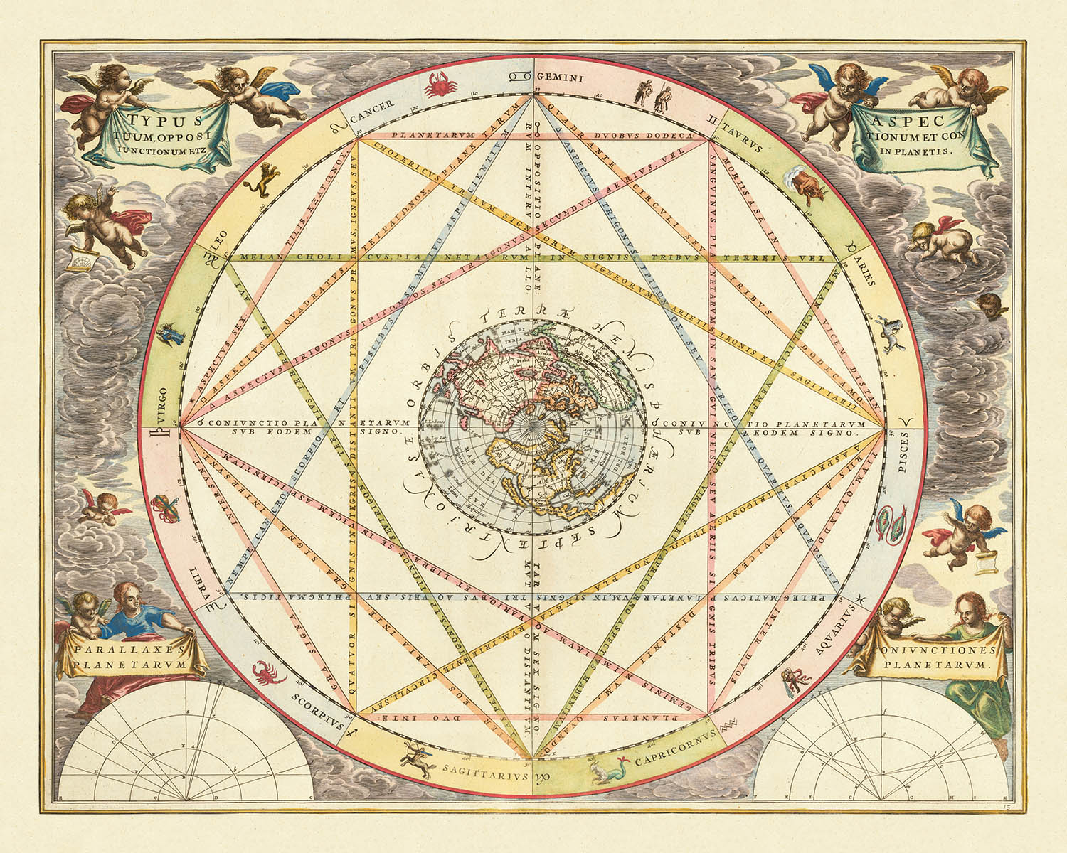
Entra nell'età dell'oro della cartografia celeste con l'opera magistrale di Andreas Cellarius, "Typus Aspectuum Oppositionum Et Coniunctionum Etz In Planetis." Realizzata nel...
Continua a leggereEntra nell'età dell'oro della cartografia celeste con l'opera magistrale di Andreas Cellarius, "Typus Aspectuum Oppositionum Et Coniunctionum Etz In Planetis." Realizzata nel 1660 e successivamente presentata nell'illustre edizione del 1708 di Valk & Schenk dell'Harmonia Macrocosmica, questa mappa fonde elegantemente i regni dell'astronomia e dell'astrologia, offrendo uno sguardo raro sulle ambizioni intellettuali e artistiche del XVII secolo. Il titolo originale in latino della mappa segnala la sua profondità tematica: uno studio degli aspetti planetari, delle opposizioni e delle congiunzioni, splendidamente illustrato attraverso l'interazione dei simboli zodiacali e dei cieli mappati.
Cellarius, una luminarie tra i cosmografi dell'epoca moderna, era rinomato per la sua capacità di tradurre i misteri del cosmo in forme visive mozzafiato. Questa carta, incisa da Joannes van Loon, esemplifica il suo genio, ponendo al centro una proiezione polare dettagliata dell'emisfero settentrionale. Qui, geografia e mitologia si intrecciano, con il focus centrale della mappa circondato da un anello circolare di segni zodiacali, ciascuno interconnesso da delicate linee che tracciano le relazioni tra i corpi celesti e i quattro umori classici. Questa sintesi di scienza e simbolismo cattura il fascino duraturo dell'era per l'armonia dell'universo.
L'arte della mappa è tanto coinvolgente quanto il suo contenuto. Cherubini radiosi fluttuano nell'etere oltre l'anello zodiacale, la loro presenza evoca la protezione celeste che era così integrale per la cosmologia dell'epoca moderna. La mappa centrale stessa è una meraviglia di dettaglio e immaginazione del periodo, raffigurando la California come un'isola misteriosa con una costa settentrionale arrotondata, una curiosità cartografica che ha affascinato esploratori e cartografi. Notabilmente, questa edizione omette il leggendario Stretto di Anian, riflettendo l'evoluzione della conoscenza geografica del tempo.
Geopoliticamente, la mappa offre un sottile commento sugli interessi europei contemporanei. Il New England e le Bermuda sono chiaramente etichettati, mentre i riferimenti alla Nuova Francia e ai Paesi Bassi sono conspicuamente assenti. La mappa presenta anche l'enigmatico N.o Albion a nord della California, insieme a due grandi fiumi nell'America del Nord occidentale, catturando sia le geografie conosciute che quelle speculative dell'era. La Florida, la Groenlandia e porzioni d'Europa e Asia sono anche visibili, tutte rese con la precisione e l'arte che definiscono l'eredità di Cellarius.
Oltre al suo immediato fascino cartografico, questa mappa si erge come un testamento dell'importanza profonda dell'astrologia alla fine del XVII secolo. L'intrecciata rete di linee che collegano i segni zodiacali, i riferimenti espliciti ai quattro umori e il design armonioso parlano di una visione del mondo in cui scienza, arte e mistica erano indissolubilmente legate. Per il collezionista discernente, la carta celeste di Cellarius non è semplicemente una mappa, ma una finestra sulle correnti filosofiche e artistiche che hanno plasmato un'epoca.
Paesi e regioni su questa mappa
- America del Nord (con la California come un'isola, New England, Florida, N.o Albion)
- Bermuda
- Europa (parti visibili nella proiezione dell'emisfero settentrionale)
- Asia (parti settentrionali visibili)
- Groenlandia
- Regioni artiche (centrali nella proiezione polare)
Caratteristiche e punti di riferimento notevoli
- Mappa centrale della proiezione polare dell'emisfero settentrionale
- California rappresentata come un'isola con una costa settentrionale arrotondata
- Due fiumi nell'America del Nord occidentale che scorrono verso sud-ovest (uno è il Rio del Norte, senza nome; l'altro è R. del nova)
- Grande massa terrestre etichettata N.o Albion a nord della California
- Bermuda e Nuova Inghilterra etichettate
- Florida etichettata
- Fascia circolare di simboli zodiacali che circonda la mappa
- Rete di linee che collegano i segni zodiacali, illustrando gli aspetti planetari
- Quattro umori (melanconia, colico, ecc.) indicati in relazione allo zodiaco
- Cherubini decorativi (angeli alati) nell'etere esterno oltre l'anello zodiacale
- Assenza di Nuova Francia e Nuove Olanda
- Nessun riferimento ad Anian (rimosso in questa edizione)
- Incisioni dettagliate e abbellimenti artistici tipici del lavoro di Cellarius
Contesto storico e di design
- Creato nel 1660 da Andreas Cellarius, successivamente presentato nell'edizione Valk & Schenk del 1708
- Inciso da Joannes van Loon
- Grafico celeste tematico che combina astronomia e astrologia
- Rappresenta aspetti planetari e relazioni astrologiche, concentrandosi sullo zodiaco e le loro connessioni con i quattro umori
- Presenta una mappa di proiezione polare dell'emisfero settentrionale al centro, circondata da una fascia circolare di segni zodiacali
- Riflette l'importanza continua dell'astrologia alla fine del XVII secolo, mescolando visioni del mondo scientifiche e mistiche
- La mappa include dettagliata geografia dell'emisfero settentrionale, con omissioni e inclusioni notevoli che riflettono gli interessi politici europei contemporanei
- Contesto artistico: splendidamente inciso, con una mappa centrale più grande che consente maggiori dettagli geografici rispetto a grafici simili di Cellarius
Si prega di controllare attentamente le immagini per assicurarsi che una specifica città o luogo sia mostrato su questa mappa. Puoi anche contattarci e chiedere di controllare la mappa per te.
Questa mappa appare fantastica in ogni dimensione, ma consiglio sempre di optare per una dimensione più grande se hai spazio. In questo modo puoi facilmente distinguere tutti i dettagli.
Questa mappa sembra incredibile in dimensioni fino a 90in (230cm). Se stai cercando una mappa più grande, per favore contattaci.
Il modello nelle immagini dell'elenco tiene la versione di questa mappa 16x20in (40x50cm).
La quinta immagine dell'elenco mostra un esempio del mio servizio di personalizzazione della mappa.
Se stai cercando qualcosa di leggermente diverso, dai un'occhiata alla mia collezione delle migliori mappe antiche per vedere se qualcosa attira la tua attenzione.
Per favore contattami per controllare se una certa posizione, punto di riferimento o caratteristica è mostrato su questa mappa.
Questa sarebbe una meravigliosa idea regalo per un compleanno, Natale, Festa del Papà, pensionamento, anniversario o inaugurazione della casa per qualcuno delle aree coperte da questa mappa.
Questa mappa è disponibile come stampa giclée su carta opaca archiviata senza acidi, oppure puoi acquistarla incorniciata. La cornice è una semplice cornice nera che si adatta alla maggior parte degli stili. Per favore contattami se desideri un colore o materiale della cornice diverso. Le mie cornici sono dotate di un acrilico super chiaro di grado museale (perspex/acrylite), che è significativamente meno riflettente del vetro, più sicuro e arriverà sempre in perfette condizioni.
This artwork is also available as a float framed canvas, sometimes known as a shadow gap framed canvas or canvas floater. The work is printed on artist's cotton canvas and then stretched over a handmade box frame. We then "float" the canvas inside a wooden frame, which is available in a range of colours (black, dark brown, oak, antique gold and white). This is a wonderful way to present an art print without glazing in front. See some examples of float framed canvas art and explore the differences between my different finishes.
Entra nell'età dell'oro della cartografia celeste con l'opera magistrale di Andreas Cellarius, "Typus Aspectuum Oppositionum Et Coniunctionum Etz In Planetis." Realizzata nel 1660 e successivamente presentata nell'illustre edizione del 1708 di Valk & Schenk dell'Harmonia Macrocosmica, questa mappa fonde elegantemente i regni dell'astronomia e dell'astrologia, offrendo uno sguardo raro sulle ambizioni intellettuali e artistiche del XVII secolo. Il titolo originale in latino della mappa segnala la sua profondità tematica: uno studio degli aspetti planetari, delle opposizioni e delle congiunzioni, splendidamente illustrato attraverso l'interazione dei simboli zodiacali e dei cieli mappati.
Cellarius, una luminarie tra i cosmografi dell'epoca moderna, era rinomato per la sua capacità di tradurre i misteri del cosmo in forme visive mozzafiato. Questa carta, incisa da Joannes van Loon, esemplifica il suo genio, ponendo al centro una proiezione polare dettagliata dell'emisfero settentrionale. Qui, geografia e mitologia si intrecciano, con il focus centrale della mappa circondato da un anello circolare di segni zodiacali, ciascuno interconnesso da delicate linee che tracciano le relazioni tra i corpi celesti e i quattro umori classici. Questa sintesi di scienza e simbolismo cattura il fascino duraturo dell'era per l'armonia dell'universo.
L'arte della mappa è tanto coinvolgente quanto il suo contenuto. Cherubini radiosi fluttuano nell'etere oltre l'anello zodiacale, la loro presenza evoca la protezione celeste che era così integrale per la cosmologia dell'epoca moderna. La mappa centrale stessa è una meraviglia di dettaglio e immaginazione del periodo, raffigurando la California come un'isola misteriosa con una costa settentrionale arrotondata, una curiosità cartografica che ha affascinato esploratori e cartografi. Notabilmente, questa edizione omette il leggendario Stretto di Anian, riflettendo l'evoluzione della conoscenza geografica del tempo.
Geopoliticamente, la mappa offre un sottile commento sugli interessi europei contemporanei. Il New England e le Bermuda sono chiaramente etichettati, mentre i riferimenti alla Nuova Francia e ai Paesi Bassi sono conspicuamente assenti. La mappa presenta anche l'enigmatico N.o Albion a nord della California, insieme a due grandi fiumi nell'America del Nord occidentale, catturando sia le geografie conosciute che quelle speculative dell'era. La Florida, la Groenlandia e porzioni d'Europa e Asia sono anche visibili, tutte rese con la precisione e l'arte che definiscono l'eredità di Cellarius.
Oltre al suo immediato fascino cartografico, questa mappa si erge come un testamento dell'importanza profonda dell'astrologia alla fine del XVII secolo. L'intrecciata rete di linee che collegano i segni zodiacali, i riferimenti espliciti ai quattro umori e il design armonioso parlano di una visione del mondo in cui scienza, arte e mistica erano indissolubilmente legate. Per il collezionista discernente, la carta celeste di Cellarius non è semplicemente una mappa, ma una finestra sulle correnti filosofiche e artistiche che hanno plasmato un'epoca.
Paesi e regioni su questa mappa
- America del Nord (con la California come un'isola, New England, Florida, N.o Albion)
- Bermuda
- Europa (parti visibili nella proiezione dell'emisfero settentrionale)
- Asia (parti settentrionali visibili)
- Groenlandia
- Regioni artiche (centrali nella proiezione polare)
Caratteristiche e punti di riferimento notevoli
- Mappa centrale della proiezione polare dell'emisfero settentrionale
- California rappresentata come un'isola con una costa settentrionale arrotondata
- Due fiumi nell'America del Nord occidentale che scorrono verso sud-ovest (uno è il Rio del Norte, senza nome; l'altro è R. del nova)
- Grande massa terrestre etichettata N.o Albion a nord della California
- Bermuda e Nuova Inghilterra etichettate
- Florida etichettata
- Fascia circolare di simboli zodiacali che circonda la mappa
- Rete di linee che collegano i segni zodiacali, illustrando gli aspetti planetari
- Quattro umori (melanconia, colico, ecc.) indicati in relazione allo zodiaco
- Cherubini decorativi (angeli alati) nell'etere esterno oltre l'anello zodiacale
- Assenza di Nuova Francia e Nuove Olanda
- Nessun riferimento ad Anian (rimosso in questa edizione)
- Incisioni dettagliate e abbellimenti artistici tipici del lavoro di Cellarius
Contesto storico e di design
- Creato nel 1660 da Andreas Cellarius, successivamente presentato nell'edizione Valk & Schenk del 1708
- Inciso da Joannes van Loon
- Grafico celeste tematico che combina astronomia e astrologia
- Rappresenta aspetti planetari e relazioni astrologiche, concentrandosi sullo zodiaco e le loro connessioni con i quattro umori
- Presenta una mappa di proiezione polare dell'emisfero settentrionale al centro, circondata da una fascia circolare di segni zodiacali
- Riflette l'importanza continua dell'astrologia alla fine del XVII secolo, mescolando visioni del mondo scientifiche e mistiche
- La mappa include dettagliata geografia dell'emisfero settentrionale, con omissioni e inclusioni notevoli che riflettono gli interessi politici europei contemporanei
- Contesto artistico: splendidamente inciso, con una mappa centrale più grande che consente maggiori dettagli geografici rispetto a grafici simili di Cellarius
Si prega di controllare attentamente le immagini per assicurarsi che una specifica città o luogo sia mostrato su questa mappa. Puoi anche contattarci e chiedere di controllare la mappa per te.
Questa mappa appare fantastica in ogni dimensione, ma consiglio sempre di optare per una dimensione più grande se hai spazio. In questo modo puoi facilmente distinguere tutti i dettagli.
Questa mappa sembra incredibile in dimensioni fino a 90in (230cm). Se stai cercando una mappa più grande, per favore contattaci.
Il modello nelle immagini dell'elenco tiene la versione di questa mappa 16x20in (40x50cm).
La quinta immagine dell'elenco mostra un esempio del mio servizio di personalizzazione della mappa.
Se stai cercando qualcosa di leggermente diverso, dai un'occhiata alla mia collezione delle migliori mappe antiche per vedere se qualcosa attira la tua attenzione.
Per favore contattami per controllare se una certa posizione, punto di riferimento o caratteristica è mostrato su questa mappa.
Questa sarebbe una meravigliosa idea regalo per un compleanno, Natale, Festa del Papà, pensionamento, anniversario o inaugurazione della casa per qualcuno delle aree coperte da questa mappa.
Questa mappa è disponibile come stampa giclée su carta opaca archiviata senza acidi, oppure puoi acquistarla incorniciata. La cornice è una semplice cornice nera che si adatta alla maggior parte degli stili. Per favore contattami se desideri un colore o materiale della cornice diverso. Le mie cornici sono dotate di un acrilico super chiaro di grado museale (perspex/acrylite), che è significativamente meno riflettente del vetro, più sicuro e arriverà sempre in perfette condizioni.
This artwork is also available as a float framed canvas, sometimes known as a shadow gap framed canvas or canvas floater. The work is printed on artist's cotton canvas and then stretched over a handmade box frame. We then "float" the canvas inside a wooden frame, which is available in a range of colours (black, dark brown, oak, antique gold and white). This is a wonderful way to present an art print without glazing in front. See some examples of float framed canvas art and explore the differences between my different finishes.
Many of our maps and art prints are chosen as thoughtful gifts for homes, offices, studies and meaningful places.
Choose a framed option for the easiest ready-to-hang gift, or choose an unframed print if the recipient may prefer to select their own frame.
We make orders locally in 23 countries around the world, so gifts can often be produced close to the recipient. This helps them arrive faster, travel more safely, and avoid customs or import duty surprises.
- We can deliver directly to the recipient
- Framed pieces arrive ready to hang
- Unframed prints are carefully packed in a strong protective tube
- Almost every order is made locally, for faster, safer gifting
- 90-day returns give the recipient time to decide
If you are not sure what to choose, please contact us. We can help you pick the right map, size, finish or delivery option.
Most orders are made locally and delivered in around 2–3 working days, depending on the product, size and destination.
We print and frame maps and artwork in 23 countries around the world, so your order is usually made close to you or your recipient. That means faster delivery, less time in transit, and no customs or import duty surprises.
Personalised and customised pieces usually take an extra 1–2 working days, because we prepare your design and send it to you for approval before printing.
Very large framed orders can take a little longer, as they need extra care in production and delivery.
Every order is carefully packaged: unframed prints are sent in a strong protective tube, while framed pieces are securely packed with protective materials around the frame.
If you need your order by a particular date, please contact us before ordering. We’ll check the best production route and delivery option for your location.
Express delivery is available at checkout for most countries. Next-day delivery is available in the UK, US, Singapore and the UAE.
Your order is covered by our 90-day returns policy and 10-year guarantee.
Our standard frame is a gallery-style black ash hardwood frame, with a simple, modern look. It is approximately 20mm (0.8in) wide. You can also view some lovely customer photos of framed maps and art.
We use super-clear acrylic glazing, also known as Perspex or Acrylite, instead of traditional glass. It is lighter, safer, and has lower reflectivity, giving the artwork a clearer, cleaner appearance.
Six standard frame colours are available at no extra cost: black, dark brown, dark grey, oak, white, and antique gold. Custom framing and mounting/matting is also available for customers looking for something more specific.
Most maps, art prints, and illustrations are also available as a framed canvas. We use matte cotton canvas, stretch it over a sustainably sourced wooden box frame, and then float the piece within a wooden outer frame. The finished result is beautifully presented, with no glazing between you and the artwork.
All frames are supplied ready to hang, with either string or brackets fitted to the back. Very large frames will include heavy-duty hanging plates and/or a mounting baton. If you have any questions, please get in touch.
We can also supply old maps and artwork on canvas, foam board, cotton rag, and other materials.
If you would prefer to frame your map or artwork yourself, please read our size guide before ordering.
My maps are extremely high quality reproductions of original maps.
I source original, rare maps from libraries, auction houses and private collections around the world, restore them at my London workshop, and then use specialist giclée inks and printers to create beautiful maps that look even better than the original.
My maps are printed on acid-free archival matte (not glossy) paper that feels very high quality and almost like card. In technical terms the paper weight/thickness is 10mil/200gsm. It's perfect for framing.
I print with Epson ultrachrome giclée UV fade resistant pigment inks - some of the best inks you can find.
I can also make maps on canvas, cotton rag and other exotic materials.
Learn more about The Unique Maps Co.
Map personalisation
If you're looking for the perfect anniversary or housewarming gift, I can personalise your map to make it truly unique. For example, I can add a short message, or highlight an important location, or add your family's coat of arms.
The options are almost infinite. Please see my map personalisation page for some wonderful examples of what's possible.
To order a personalised map, select "personalise your map" before adding it to your basket.
Get in touch if you're looking for more complex customisations and personalisations.
Map ageing
I have been asked hundreds of times over the years by customers if they could buy a map that looks even older.
Well, now you can, by selecting Aged before you add a map to your basket.
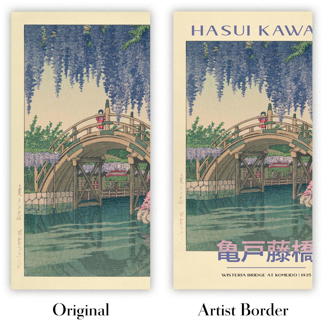
All the product photos you see on this page show the map in its Original form. This is what the map looks like today.
If you select Aged, I will age your map by hand, using a special and unique process developed through years of studying old maps, talking to researchers to understand the chemistry of aging paper, and of course... lots of practice!
If you're unsure, stick to the Original colour of the map. If you want something a bit darker and older looking, go for Aged.
Se non sei soddisfatto del tuo ordine per qualsiasi motivo, contattami per un rimborso senza problemi. Si prega di consultare la nostra politica di reso e rimborso per ulteriori informazioni.
Sono molto sicuro che ti piacerà la tua mappa restaurata o la stampa d'arte. Lo faccio dal 1984. Sono un venditore Etsy a 5 stelle. Ho venduto decine di migliaia di mappe e stampe d'arte e ho oltre 5.000 recensioni reali a 5 stelle.
Utilizzo un processo unico per restaurare mappe e opere d'arte che richiede molto tempo e lavoro. Trovare le mappe e le illustrazioni originali può richiedere mesi. Utilizzo tecnologia all'avanguardia e incredibilmente costosa per scannerizzare e restaurarle. Di conseguenza, garantisco che le mie mappe e stampe d'arte siano superiori alle altre - ecco perché posso offrire un rimborso senza problemi.
Quasi tutte le mie mappe e stampe d'arte sembrano fantastiche a grandi dimensioni (200 cm, 6,5 piedi+) e posso anche incorniciarle e consegnarle a te, tramite un corriere speciale per oggetti di grandi dimensioni. Contattami per discutere delle tue esigenze specifiche.


