


Ancienne carte de l'Europe par John Tallis, 1851: chasse aux phoques, chameaux, marché aux esclaves, etc.
20% de réduction sur 2 — 33% de réduction sur 3
Ajoutez n'importe quel deux articles éligibles à votre panier pour recevoir 20% de réduction. Ajoutez un troisième et il sera offert (équivalent à 33% de réduction lors de l'achat de trois).
Aucun code nécessaire — l'offre s'applique automatiquement au moment du paiement.
Valide sur toutes les cartes standard et les impressions d'art. Vous pouvez mélanger et assortir n'importe quel design.
Si vous souhaitez expédier des articles à plusieurs adresses, veuillez nous contacter avant de passer votre commande.
Les commandes personnalisées et sur mesure sont exclues.
Contactez-nous si vous avez des questions
- All taxes and duties included
- Handmade & dispatched in 1-2 days
-
Complimentary gifting & design advice
ⓘ
Complimentary gifting & design advice
Available almost 24/7 on WhatsApp and email — we usually reply within minutes. We can help you:
- Choose a perfectly personalised gift
- Send a digital gift preview to the recipient
- Pick the ideal size for your wall
- Select the right finish and frame
Quick, friendly advice so you can order with confidence.
For last minute gifts, consider buying a digital gift card. We have over 5,000 maps and art prints to choose from.
-
90-day returns & 5-year guarantee
ⓘ
90 jours pour retourner et obtenir un remboursement
Les produits peuvent être retournés dans les 90 jours pour un remboursement complet, ou un échange contre un autre produit.
Pour les articles personnalisés et faits sur mesure, nous pouvons vous offrir un crédit en magasin ou une carte-cadeau non expirante, car nous ne pouvons pas revendre les commandes personnalisées.
Si vous avez des questions, contactez-nous. Pour plus d'informations, consultez notre politique de retours et d'échanges.

This is a museum-grade archival print from the original 1851 map — restored in our workshop and made to order on 220gsm archival matte paper or 400gsm artist's cotton canvas with pigment inks.
Professional framing & free personalisation available.
1. Choose a size
2. Frame & personalise your map
Make your map unique with framing, hand-drawn customisation, vintage ageing, pop art text, unique 3D styling and more.


Message cadeau & finition personnalisée

Si vous souhaitez ajouter un message cadeau, ou une finition (puzzle, panneau en aluminium, etc.) qui n'est pas disponible ici, veuillez le demander dans la "note de commande" lors de votre passage à la caisse.
Chaque commande est fabriquée sur mesure, donc si vous avez besoin d'ajuster légèrement la taille, ou d'imprimer sur un matériau inhabituel, faites-le nous savoir. Nous avons réalisé des milliers de commandes personnalisées au fil des ans, donc il n'y a (presque) rien que nous ne puissions gérer.
Vous pouvez également nous contacter avant de passer votre commande, si vous le souhaitez !

- Handmade locally. No import duty or tax
- FREE worldwide delivery
- 90-day returns & 5-year product guarantee
- Questions? WhatsApp me any time
Own a piece of history
7,000+ 5 star reviews


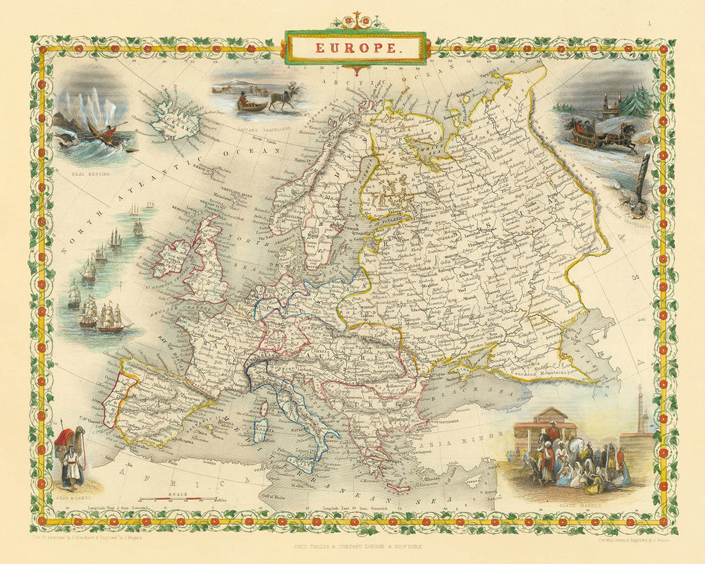
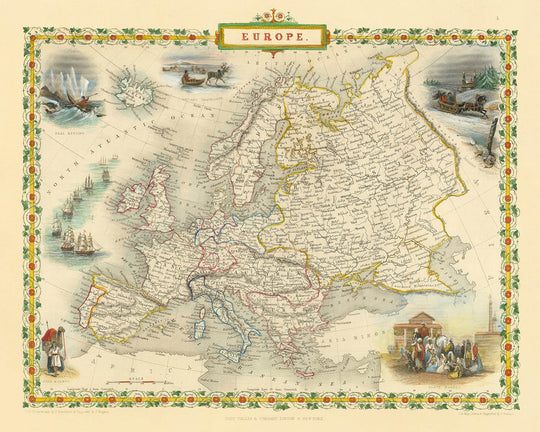
Entrez dans la riche tapisserie de l'Europe du XIXe siècle avec « Europe », la carte originale de 1851 magistralement réalisée par John Tallis. Portant son titre historique, cette carte est plus qu'un simple enregistrement géographique : c'est une fenêtre vivante sur un continent à l'aube de la transformation. Commandée pour l'Illustrated Atlas célébré de R. Montgomery Martin, l'œuvre de Tallis encapsule le paysage politique et physique de l'Europe à un moment clé, lorsque les empires s'étendaient au-delà des frontières et que l'attention du monde était fixée sur l'exploration, le commerce et les échanges culturels.
John Tallis se classe parmi les derniers grands cartographes décoratifs, renommé pour son attention exquise aux détails et sa capacité à tisser l'art dans la cartographie. Ses cartes sont prisées par les collectionneurs et les historiens, non seulement pour leur précision mais aussi pour leur beauté. Cette carte particulière met en avant le style signature de Tallis : une composition finement gravée en couleurs, encadrée par une bordure décorative ornée, invitant les spectateurs à s'attarder à la fois sur la géographie et l'art. Le rendu méticuleux des chaînes de montagnes, des rivières et des côtes reflète les normes élevées de la cartographie de l'époque victorienne.
Ce qui distingue cette carte, ce sont les vignettes évocatrices qui entourent l'image centrale. Des scènes telles que le « Marché aux esclaves », la « Chasse aux phoques », les « Voyageurs de Laponie » et les « Arabes et chameaux » offrent un aperçu des réalités économiques, culturelles et ethnographiques de l'époque. Ces illustrations ne sont pas de simples embellissements ; ce sont des documents historiques à part entière, capturant la fascination — et parfois les préjugés — de l'Europe du XIXe siècle envers des terres et des peuples lointains. Les vignettes transforment la carte en un récit, racontant des histoires de commerce, de voyage et de rencontre.
Le contenu de la carte est aussi complet que beau. Les grandes rivières comme le Danube et le Rhin, des chaînes de montagnes imposantes telles que les Alpes et les Carpates, et des plans d'eau significatifs, notamment la Méditerranée et la mer Baltique, sont tous clairement délimités. Les villes clés — Londres, Paris, Vienne, Moscou, et plus — ancrent la carte, tandis que des îles comme l'Islande et la Sicile sont rendues avec une précision soignée. Les divisions politiques de l'époque sont fidèlement représentées, avec le patchwork des États allemands, l'influence des empires russe et ottoman, et la Grèce nouvellement indépendante, offrant un instantané des frontières complexes et en constante évolution de l'Europe.
Historiquement, cette carte se dresse comme un témoignage d'une période d'intense curiosité et d'expansion. Elle reflète non seulement la géographie physique de l'Europe mais aussi les courants intellectuels de son époque : l'élan d'explorer, de documenter et de comprendre le monde dans toute sa diversité. Pour le collectionneur avisé, « Europe » par John Tallis est plus qu'une carte : c'est un morceau d'histoire, une œuvre d'art, et une occasion rare de posséder un lien tangible avec le passé chargé du continent.
Pays et régions sur cette carte
- Grande-Bretagne (Angleterre, Écosse, Pays de Galles)
- Irlande
- France
- Espagne
- Portugal
- Italie (y compris des étiquettes séparées pour des régions comme la Sardaigne, la Sicile, et la Corse)
- Suisse
- Belgique
- Pays-Bas
- États allemands (y compris la Prusse, la Bavière, la Saxe, Hanovre, etc.)
- Autriche (Empire autrichien)
- Hongrie
- Pologne (comme partie d'autres empires ou territoires)
- Russie
- Danemark
- Suède et Norvège (unies à l'époque)
- Finlande (partie de l'Empire russe à l'époque)
- Empire ottoman (y compris les régions du sud-est de l'Europe)
- Grèce
- Régions des Balkans (comme la Serbie, la Bosnie, la Valachie, la Moldavie)
- Lapland (Scandinavie du Nord)
- Islande
Caractéristiques et monuments notables
- Bord décoratif avec des œuvres d'art et des couleurs complexes
- Vignette intitulée "Marché aux esclaves" représentant le commerce historique des esclaves
- Vignette intitulée "Chasse aux phoques" illustrant l'activité économique liée à la chasse et au commerce
- Vignette intitulée "Voyageurs de Laponie" montrant des peuples autochtones et leur mode de transport
- Vignette intitulée "Arabes et chameaux" représentant les interactions culturelles et commerciales
- Corps d'eau majeurs clairement étiquetés, y compris l'océan Atlantique, la mer Méditerranée, la mer du Nord, la mer Baltique et la mer Noire
- Chaînes de montagnes clairement représentées, y compris les Alpes, les Pyrénées et les Carpates
- Principaux rivières comme le Danube, le Rhin et la Volga sont clairement étiquetées et visibles
- Villes majeures clairement étiquetées, y compris Londres, Paris, Vienne, Berlin, Madrid, Rome et Moscou
- Îles telles que l'Islande, la Corse, la Sardaigne, la Sicile et les îles britanniques clairement représentées et étiquetées
Contexte historique et de conception
- Créé en 1851 par John Tallis, l'un des derniers grands cartographes décoratifs
- Gravé pour l'Atlas illustré de R. Montgomery Martin
- Notable pour son magnifique style décoratif en couleurs et ses vignettes détaillées illustrant des scènes telles qu'un marché aux esclaves, la chasse aux phoques, les voyageurs de Laponie et les Arabes avec des chameaux
- Décoratif et détaillé, caractérisé par des bordures élaborées et des vignettes artistiques représentant des scènes culturelles et indigènes
- Réflecte la géographie européenne du milieu du XIXe siècle, les intérêts coloniaux, la curiosité ethnographique et les activités économiques
- Les vignettes donnent un aperçu des perceptions et des intérêts européens en ethnographie et en commerce durant le milieu du XIXe siècle
Veuillez vérifier les images pour vous assurer qu'une ville ou un lieu spécifique est montré sur cette carte. Vous pouvez également nous contacter et nous demander de vérifier la carte pour vous.
Cette carte a fière allure à toutes les tailles, mais je recommande toujours d'opter pour une taille plus grande si vous avez de l'espace. De cette façon, vous pouvez facilement distinguer tous les détails.
Cette carte est incroyable à des tailles allant jusqu'à 50 pouces (125 cm). Si vous recherchez une carte plus grande, veuillez nous contacter.
Le modèle dans les images de la liste tient la version 16x20 pouces (40x50 cm) de cette carte.
La cinquième image de la liste montre un exemple de mon service de personnalisation de carte.
Si vous recherchez quelque chose de légèrement différent, consultez ma collection des meilleures anciennes cartes pour voir si quelque chose d'autre attire votre attention.
Veuillez me contacter pour vérifier si un certain emplacement, monument ou caractéristique est montré sur cette carte.
Cela ferait un merveilleux cadeau d'anniversaire, de Noël, pour la fête des pères, un départ au travail, un anniversaire de mariage ou une pendaison de crémaillère pour quelqu'un des régions couvertes par cette carte.
Cette carte est disponible en tant qu'impression giclée sur papier mat d'archivage sans acide, ou vous pouvez l'acheter encadrée. Le cadre est un joli cadre noir simple qui convient à la plupart des esthétiques. Veuillez nous contacter si vous souhaitez une couleur ou un matériau de cadre différent. Mes cadres sont en verre acrylique super clair de qualité musée (perspex/acrylite), qui est significativement moins réfléchissant que le verre, plus sûr, et arrivera toujours en parfait état.
This map is also available as a float framed canvas, sometimes known as a shadow gap framed canvas or canvas floater. The map is printed on artist's cotton canvas and then stretched over a handmade box frame. We then "float" the canvas inside a wooden frame, which is available in a range of colours (black, dark brown, oak, antique gold and white). This is a wonderful way to present a map without glazing in front. See some examples of float framed canvas maps and explore the differences between my different finishes.
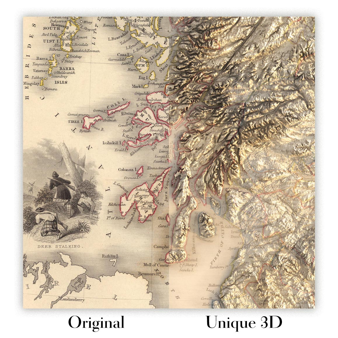
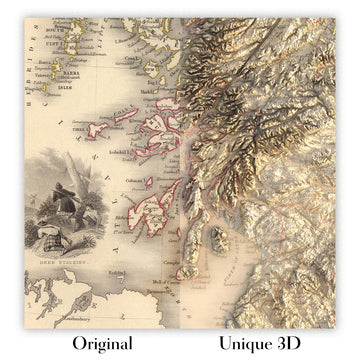
For something truly unique, this map is also available in "Unique 3D", our trademarked process that dramatically transforms the map so that it has a wonderful sense of depth. We combine the original map with detailed topography and elevation data, so that mountains and the terrain really "pop". For more info and examples of 3D maps, check my Unique 3D page.
Pour la plupart des commandes, le délai de livraison est d'environ 3 jours ouvrables. Les produits personnalisés et sur mesure prennent plus de temps, car je dois faire la personnalisation et vous l'envoyer pour approbation, ce qui prend généralement 1 ou 2 jours.
Veuillez noter que les grandes commandes encadrées prennent généralement plus de temps à réaliser et à livrer.
Si vous avez besoin que votre commande arrive à une date précise, veuillez me contacter avant de passer votre commande afin que nous puissions trouver le meilleur moyen de nous assurer que vous receviez votre commande à temps.
J'imprime et encadre des cartes et des œuvres d'art dans 23 pays à travers le monde. Cela signifie que votre commande sera réalisée localement, ce qui réduit le temps de livraison et garantit qu'elle ne sera pas endommagée pendant le transport. Vous ne paierez jamais de droits de douane ou d'importation, et nous mettrons moins de CO2 dans l'air.
Toutes mes cartes et impressions artistiques sont bien emballées et envoyées dans un tube robuste si non encadrées, ou entourées de mousse si encadrées.
J'essaie d'envoyer toutes les commandes dans les 1 ou 2 jours suivant la réception de votre commande, bien que certains produits (comme les masques, les mugs et les sacs fourre-tout) puissent prendre plus de temps à réaliser.
Si vous choisissez Livraison Express lors du paiement, nous donnerons la priorité à votre commande et l'enverrons par un service de messagerie de 1 jour (Fedex, DHL, UPS, Parcelforce).
La livraison le lendemain est également disponible dans certains pays (États-Unis, Royaume-Uni, Singapour, Émirats Arabes Unis), mais veuillez essayer de commander tôt dans la journée afin que nous puissions l'envoyer à temps.
Lisez mon guide complet sur la livraison et la production locale
Mon cadre standard est un cadre en bois dur noir de style galerie. Il est simple et a un aspect assez moderne. Mon cadre standard mesure environ 20 mm (0,8 po) de large.
J'utilise de l'acrylique super clair (perspex/acrylite) pour le verre du cadre. C'est plus léger et plus sûr que le verre - et cela a meilleur aspect, car la réflexivité est plus faible.
Six couleurs de cadre standard sont disponibles gratuitement (noir, marron foncé, gris foncé, chêne, blanc et or antique). Des encadrements et montages/matelassages personnalisés sont disponibles si vous recherchez autre chose.
La plupart des cartes, œuvres d'art et illustrations sont également disponibles sous forme de toile encadrée. Nous utilisons une toile en coton mate (non brillante), que nous tendons sur un cadre en bois de boîte provenant de sources durables, puis nous 'flottions' la pièce à l'intérieur d'un cadre en bois. Le résultat final est assez beau, et il n'y a pas de vitrage qui gêne.
Tous les cadres sont fournis "prêts à accrocher", avec soit une corde, soit des supports à l'arrière. Les très grands cadres auront des plaques de suspension lourdes et/ou une latte de montage. Si vous avez des questions, veuillez nous contacter.
Voir quelques exemples de mes cartes encadrées et de cartes en toile encadrées.
Alternativement, je peux également fournir de vieilles cartes et œuvres d'art sur toile, sur panneau en mousse, en coton et d'autres matériaux.
Si vous souhaitez encadrer votre carte ou œuvre d'art vous-même, veuillez lire d'abord mon guide des tailles.
Certaines de mes anciennes cartes sont maintenant disponibles en tant que toiles encadrées. Veuillez me contacter si vous souhaitez commander une taille qui n'est pas disponible dans ma boutique.
Les anciennes cartes en toile sont une alternative intéressante aux cartes encadrées de manière conventionnelle. Selon vos goûts personnels et la décoration de votre pièce, les cartes en toile peuvent "se démarquer" un peu plus qu'une carte encadrée.
Mes cartes sont des reproductions de cartes originales de très haute qualité.
Je recherche des cartes originales et rares auprès de bibliothèques, de maisons de ventes aux enchères et de collections privées du monde entier, je les restaure dans mon atelier de Londres, puis j'utilise des encres et des imprimantes giclées spécialisées pour créer de magnifiques cartes encore plus belles que l'originale.
Mes cartes sont imprimées sur du papier d’archives mat (non brillant) sans acide qui semble de très haute qualité et ressemble presque à une carte. En termes techniques, le grammage/épaisseur du papier est de 10 mil/200 g/m². C'est parfait pour l'encadrement.
J’imprime avec des encres pigmentaires Epson ultrachrome giclée UV résistantes à la décoloration – certaines des meilleures encres que vous puissiez trouver.
je peux aussi faire cartes sur toile, chiffon en coton et autres matériaux exotiques.
En savoir plus sur Unique Maps Co..
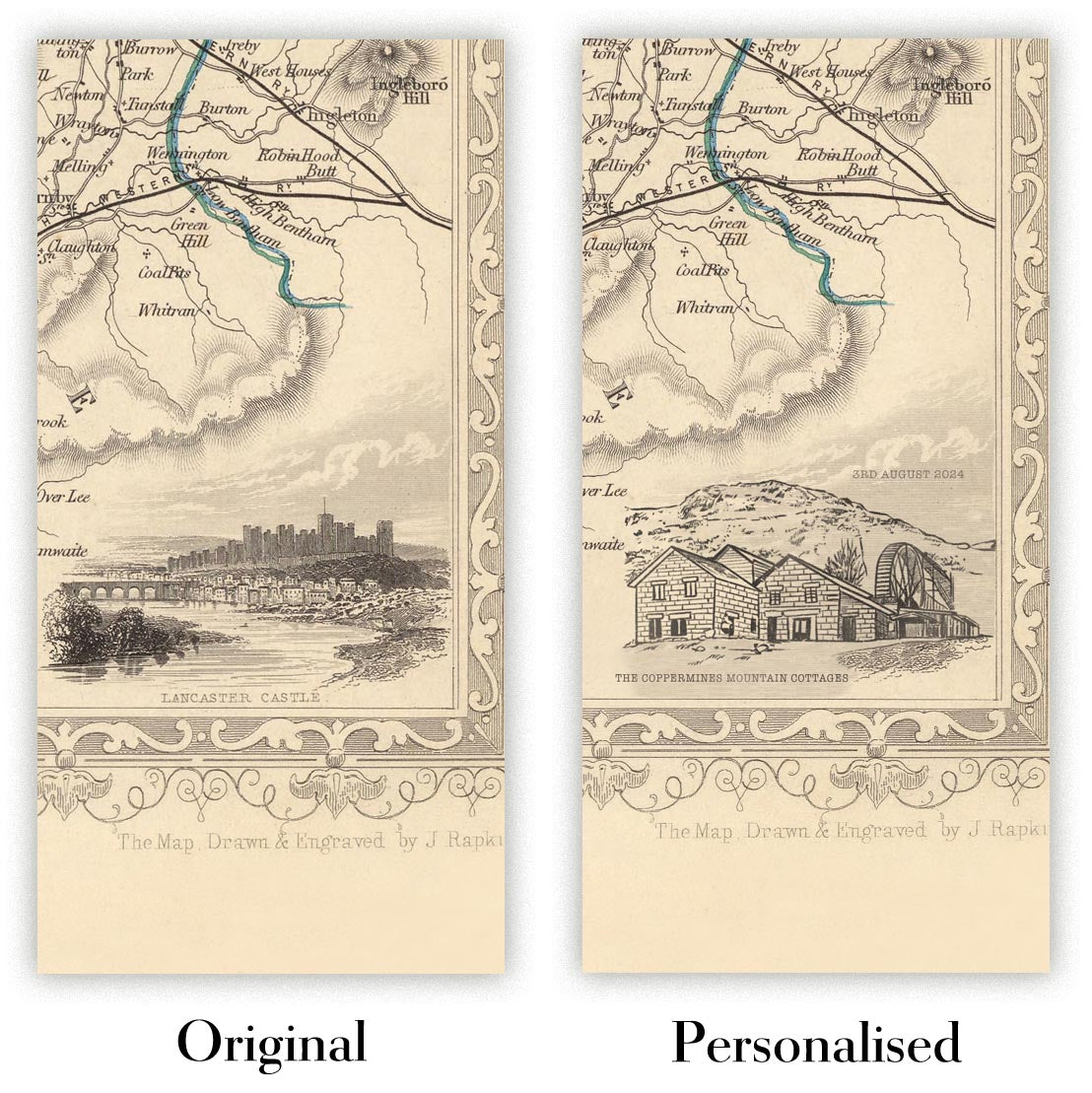
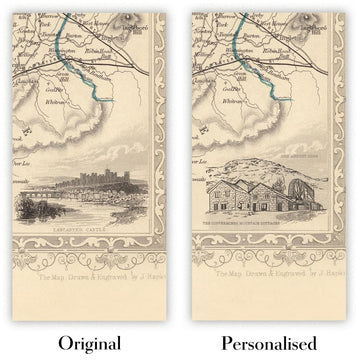
Personnalisation de la carte
Si vous recherchez le cadeau parfait pour un anniversaire ou une pendaison de crémaillère, je peux personnaliser votre carte pour la rendre vraiment unique. Par exemple, je peux ajouter un court message, mettre en évidence un lieu important ou ajouter les armoiries de votre famille.
Les options sont presque infinies. S'il vous plaît voir mon page de personnalisation de la carte pour quelques merveilleux exemples de ce qui est possible.
Pour commander une carte personnalisée, sélectionnez « personnaliser votre carte » avant de l'ajouter à votre panier.
Entrer en contact si vous recherchez des personnalisations et des personnalisations plus complexes.
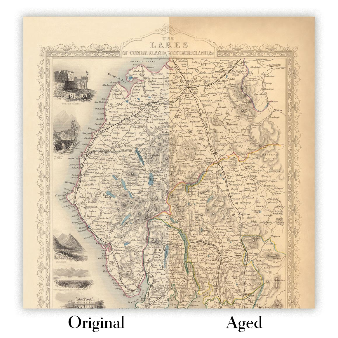
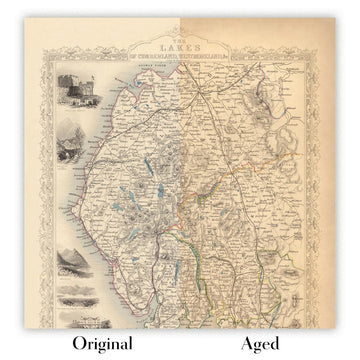
Vieillissement de la carte
Au fil des ans, des clients m'ont demandé des centaines de fois s'ils pouvaient acheter une carte qui semble uniforme. plus vieux.
Eh bien, vous pouvez désormais le faire en sélectionnant Aged avant d'ajouter une carte à votre panier.
Toutes les photos de produits que vous voyez sur cette page montrent la carte dans sa forme originale. Voilà à quoi ressemble la carte aujourd'hui.
Si vous sélectionnez Vieilli, je vieillirai votre carte à la main, en utilisant un processus spécial et unique développé au cours d'années d'étude de cartes anciennes, de discussions avec des chercheurs pour comprendre la chimie du vieillissement du papier, et bien sûr... beaucoup de pratique !
Si vous n'êtes pas sûr, respectez la couleur originale de la carte. Si vous voulez quelque chose d'un peu plus sombre et plus vieux à la recherche, optez pour Aged.
Si vous n'êtes pas satisfait de votre commande pour une raison quelconque, contactez-moi pour un remboursement sans conditions. Veuillez consulter notre politique de retours et de remboursements pour plus d'informations.
Je suis très confiant que vous aimerez votre carte restaurée ou votre impression artistique. Je fais cela depuis 1984. Je suis un vendeur Etsy 5 étoiles. J'ai vendu des dizaines de milliers de cartes et d'impressions artistiques et j'ai plus de 5 000 vrais avis 5 étoiles.
J'utilise un processus unique pour restaurer des cartes et des œuvres d'art qui est extrêmement chronophage et exigeant en main-d'œuvre. Trouver les cartes et illustrations originales peut prendre des mois. J'utilise une technologie de pointe et incroyablement coûteuse pour les numériser et les restaurer. En conséquence, je garantis que mes cartes et impressions artistiques sont d'une qualité supérieure - c'est pourquoi je peux offrir un remboursement sans conditions.
Presque toutes mes cartes et impressions artistiques ont l'air incroyables en grandes tailles (200 cm, 6,5 pieds+) et je peux également les encadrer et vous les livrer, via un transporteur spécial surdimensionné. Contactez-moi pour discuter de vos besoins spécifiques.
Or try searching for something!


