

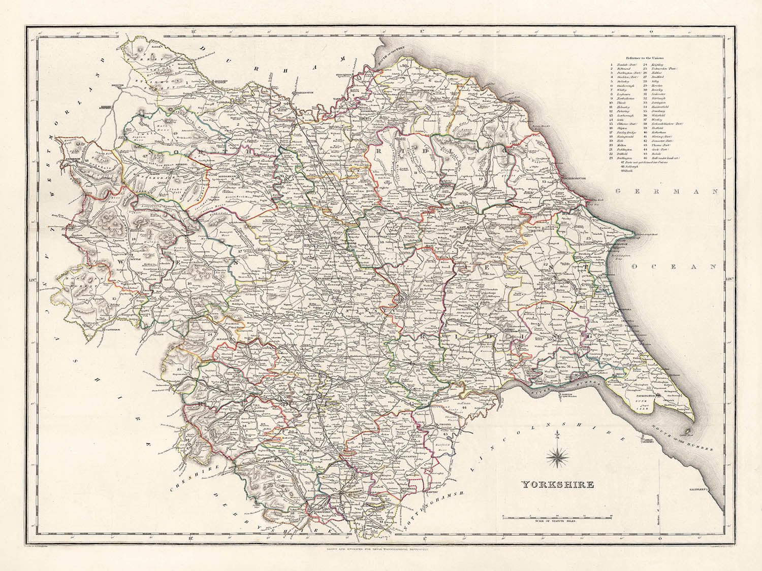


Ancienne carte du Yorkshire par Samuel Lewis, 1844: Leeds, Sheffield, Bradford, Kingston upon Hull et York
Achetez 2, obtenez 1 gratuit
Si vous ajoutez 2 articles à votre panier, vous pouvez ajouter un troisième produit gratuitement.
Cela fonctionne pour toutes les cartes et œuvres d'art, y compris les pièces personnalisées et sur mesure. Vous pouvez commander 3 de la même chose, ou 3 choses différentes.
Cela équivaut à une remise de 33 %, qui sera la plus grande remise disponible dans ma boutique cette année.
Veuillez profiter de l'offre et couvrir vos murs de belles cartes et œuvres d'art !
Contactez-moi si vous avez des questions.
- All taxes and duties included
- Handmade & dispatched in 1-2 days
-
Complimentary gifting & design advice
ⓘ
Complimentary gifting & design advice
Available almost 24/7 on WhatsApp and email — we usually reply within minutes. We can help you:
- Choose a perfectly personalised gift
- Send a digital gift preview to the recipient
- Pick the ideal size for your wall
- Select the right finish and frame
Quick, friendly advice so you can order with confidence.
For last minute gifts, consider buying a digital gift card. We have over 5,000 maps and art prints to choose from.
-
90-day returns & 5-year guarantee
ⓘ
90 jours pour retourner et obtenir un remboursement
Les produits peuvent être retournés dans les 90 jours pour un remboursement complet, ou un échange contre un autre produit.
Pour les articles personnalisés et faits sur mesure, nous pouvons vous offrir un crédit en magasin ou une carte-cadeau non expirante, car nous ne pouvons pas revendre les commandes personnalisées.
Si vous avez des questions, contactez-nous. Pour plus d'informations, consultez notre politique de retours et d'échanges.

This is a museum-grade archival print from the original 1844 map — restored in our workshop and made to order on 220gsm archival matte paper or 400gsm artist's cotton canvas with pigment inks.
Professional framing & free personalisation available.
1. Choose a size
2. Frame & personalise your map
Make your map unique with framing, hand-drawn customisation, vintage ageing, pop art text, unique 3D styling and more.


Message cadeau & finition personnalisée

Si vous souhaitez ajouter un message cadeau, ou une finition (puzzle, panneau en aluminium, etc.) qui n'est pas disponible ici, veuillez le demander dans la "note de commande" lors de votre passage à la caisse.
Chaque commande est fabriquée sur mesure, donc si vous avez besoin d'ajuster légèrement la taille, ou d'imprimer sur un matériau inhabituel, faites-le nous savoir. Nous avons réalisé des milliers de commandes personnalisées au fil des ans, donc il n'y a (presque) rien que nous ne puissions gérer.
Vous pouvez également nous contacter avant de passer votre commande, si vous le souhaitez !

- Handmade locally. No import duty or tax
- FREE worldwide delivery
- 90-day returns & 5-year product guarantee
- Questions? WhatsApp me any time
Own a piece of history
7,000+ 5 star reviews


Reculez dans le temps avec cette carte à couper le souffle, méticuleusement détaillée du Yorkshire de 1844, réalisée par le célèbre cartographe Samuel Lewis. Cette œuvre d'art représente avec précision les frontières historiques du Yorkshire à une époque où de nombreuses villes et bourgades étaient aux premiers stades de leur ascension industrielle. C'est une fenêtre sur une époque révolue, où certaines villes modernes n'existaient peut-être pas encore, ou existaient sous un autre nom, offrant un récit intrigant sur le développement de cette région historiquement riche.
Cette pièce magnifique détient non seulement une immense valeur historique, mais elle sert également de point de discussion excellent. Que ce soit la transformation profonde de Leeds, passant d'une modeste bourgade de marché à une ville industrielle animée, ou le charme durable de York, cette carte offre un aperçu fascinant du passé du Yorkshire. C'est une pièce parfaite pour les historiens, les cartographes, ou quiconque s'intéresse à la riche tapisserie du passé du Yorkshire. L'esthétique intemporelle de la carte en fait un excellent ajout à tout décor.
Villes et Bourgades Notables :- Leeds (5ème Siècle) : Leeds était une petite bourgade seigneuriale au 13ème siècle, et au cours des siècles suivants, elle s'est agrandie et développée en un important centre de production et de commerce de laine.
- Sheffield (environ 8ème Siècle) : Connue pour son rôle significatif dans la Révolution industrielle, Sheffield a commencé comme un petit village centré autour du château de Sheffield.
- Bradford (Moyen Âge) : Bradford a connu une croissance rapide au 19ème siècle en tant que centre international de fabrication textile, en particulier de laine.
- Kingston upon Hull (12ème Siècle) : Fondée par Édouard Ier, Hull a été une ville de marché, un port de fournitures militaires, un hub commercial et une métropole industrielle.
- York (71 ap. J.-C.) : Fondée par les Romains sous le nom d'Eboracum, York était la capitale de la province romaine de Britannia Inferior.
- Wakefield (Charte de Wakefield de 1203) : Wakefield était surnommée la "Merrie City" au Moyen Âge et était historiquement la capitale du West Riding du Yorkshire.
- Doncaster (1er Siècle ap. J.-C.) : À l'origine un fort romain occupé appelé Danum, Doncaster a longtemps été une région riche en raison de son importance stratégique sur la rivière Don.
- Rotherham (9ème Siècle) : Au Moyen Âge, Rotherham était un centre clé de l'industrie du fer et est devenue plus tard un principal bassin houiller du sud du Yorkshire.
- Halifax (12ème Siècle) : Halifax est connue pour sa riche histoire dans la laine, son impressionnante architecture victorienne et le unique Piece Hall.
- Barnsley (Moyen Âge) : Barnsley est devenue un centre de production de lin en Angleterre, alimentée par son accès au charbon et au fer.
- Huddersfield (1066) : Huddersfield était une ville de marché connue pour son rôle dans la Révolution industrielle et pour être le berceau du rugby league.
- Harrogate (16ème Siècle) : Destination touristique populaire et ville thermale, ses sources ont été découvertes au 16ème siècle.
- Scarborough (966 ap. J.-C.) : Cette ville balnéaire historique sur la côte de la mer du Nord est la première station balnéaire de Grande-Bretagne.
- Batley (Fin du Moyen Âge) : Pendant la Révolution industrielle, Batley était l'un des principaux centres de shoddy et de mungo, un tissu bon marché fabriqué à partir de laine recyclée ou déchiquetée.
- Keighley (Moyen Âge) : Les usines de Keighley produisaient des textiles pour équiper les soldats, contribuant grandement à l'effort de guerre pendant les guerres napoléoniennes.
- Castleford (Époque Romaine) : L'histoire de Castleford remonte à l'époque romaine, quand elle s'appelait Lagentium.
- Pontefract (1086) : Pontefract était une importante ville marchande avec un château royal au Moyen Âge.
- Wetherby (12ème siècle) : Wetherby était une étape pour voyager entre Londres, le Nord et l'Écosse.
- Beverley (7ème siècle) : Beverley était un lieu de pèlerinage pour beaucoup, ayant été un sanctuaire pour les criminels au Moyen Âge.
- Middlesbrough (1830) : Middlesbrough était une ferme qui est devenue un géant industriel grâce aux industries du charbon et du fer.
- Pocklington (1er siècle après J.-C.) : Connue comme la "Porte des Yorkshire Wolds", Pocklington est une ancienne ville marchande, fondée par les Angles.
- Ilkley (Temps romains) : Ilkley était un fort romain, et aujourd'hui elle est célèbre pour sa lande.
- Northallerton (Temps romains) : Les Romains avaient une station de signal ici et les Vikings lui ont donné son nom.
- Richmond (1071) : Le château de Richmond, construit en 1071, a eu une grande influence sur le développement de la ville de Richmond.
- Selby (14ème siècle) : Selby a une riche histoire maritime et est le lieu de naissance du roi Henri Ier d'Angleterre.
- Hornsea (12ème siècle) : Petite station balnéaire, Hornsea est connue pour son charme de l'époque victorienne.
- Hedon (12ème siècle) : Hedon était un port de commerce important, dont les fondations sont encore visibles aujourd'hui.
- Howden (7ème siècle) : C'est une ville marchande historique avec une belle Minster qui était autrefois un important centre ecclésiastique.
- Knaresborough (1086) : Le château de Knaresborough date de l'époque normande, et la ville est pleine d'histoire fascinante.
- Skipton (1086) : Skipton, la "Porte des Dales", possède un château médiéval bien préservé.
- Parc national des Yorkshire Dales : Établi en 1954, le parc est célèbre pour ses paysages à couper le souffle, son riche patrimoine culturel et sa faune diversifiée.
- Les North York Moors : Un parc national avec l'une des plus grandes étendues de landes de bruyère au Royaume-Uni.
- La rivière Ouse et la rivière Aire : Deux grandes rivières traversant le Yorkshire, avec des chemins pittoresques et beaucoup de faune.
- Ilkley Moor : Connue pour son habitat de haute altitude et ses vestiges archéologiques, c'est une destination populaire pour la randonnée et l'escalade.
- Flamborough Head : L'une des zones de falaises de craie les plus spectaculaires de Grande-Bretagne, elle abrite l'un des plus grands sites de nidification des oiseaux de mer.
- La guerre de 1812 (1812-1815) : Ce conflit a impliqué de nombreux soldats du Yorkshire, y compris des régiments de Hull et Halifax.
- Les soulèvements luddites (1811-1816) : Escarmouches entre l'armée britannique et des travailleurs protestant contre l'utilisation de machines dans les industries de la laine et du coton.
- Ouverture du canal de Leeds et Liverpool (1816) : Cette importante voie de transport a donné un coup de pouce économique aux villes et aux cités le long de son parcours.
- Formation du Yorkshire County Cricket Club (1863) : Fondé le 8 janvier, il est depuis devenu l'un des clubs de cricket les plus performants d'Angleterre.
- Le Great Reform Act (1832) : De nombreuses villes du Yorkshire, y compris Leeds et Sheffield, ont obtenu une représentation au Parlement grâce à cet acte.
- Fondation de Middlesbrough (1830) : Middlesbrough était une ferme qui s'est transformée en un géant industriel grâce aux industries du charbon et du fer.
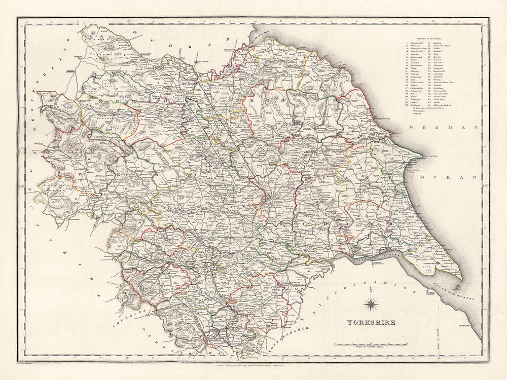
Veuillez vérifier les images pour vous assurer qu'une ville ou un lieu spécifique est montré sur cette carte. Vous pouvez également nous contacter et nous demander de vérifier la carte pour vous.
Cette carte est superbe à toutes les tailles : 12x16in (30.5x41cm), 18x24in (45.5x61cm), 16x20in (40.5x51cm), 24x36in (61x91.5cm), 30x40in (76x101.5cm), 37x50in (94x127cm), 45x60in (114x152.5cm) et 52x70in (132x178cm), mais elle est encore plus belle lorsqu'elle est imprimée en grand.
Je peux créer de belles impressions grand format de cette carte jusqu'à 50in (127cm). N'hésitez pas à me contacter si vous recherchez des options de cadre plus grandes, personnalisées ou différentes.
Le modèle sur les images de l'annonce tient la version 18x24in (45.5x61cm) de cette carte.
La cinquième image de l'annonce montre un exemple de mon service de personnalisation de carte.
Les étiquettes sur cette carte sont très petites à 12x16in (30.5x41cm). La carte est toujours très attrayante, mais vous pourriez avoir du mal à lire les plus petites lettres. Veuillez acheter une carte plus grande s'il est important de pouvoir lire la carte facilement.
Si vous recherchez quelque chose d'un peu différent, consultez ma collection principale de cartes du Royaume-Uni et d'Irlande.
Veuillez me contacter pour vérifier si un certain emplacement, monument ou caractéristique est représenté sur cette carte.
Cela ferait un merveilleux cadeau d'anniversaire, de Noël, pour la fête des pères, de départ au travail, d'anniversaire de mariage ou de pendaison de crémaillère pour quelqu'un des régions couvertes par cette carte.
Cette carte est disponible en tant qu'impression giclée sur papier mat d'archive sans acide, ou vous pouvez l'acheter encadrée. Le cadre est un joli cadre noir simple qui convient à la plupart des esthétiques. N'hésitez pas à me contacter si vous souhaitez une couleur ou un matériau de cadre différent. Mes cadres sont vitrées avec un acrylique de musée super clair (perspex/acrylite), qui est significativement moins réfléchissant que le verre, plus sûr, et arrivera toujours en parfait état.
This map is also available as a float framed canvas, sometimes known as a shadow gap framed canvas or canvas floater. The map is printed on artist's cotton canvas and then stretched over a handmade box frame. We then "float" the canvas inside a wooden frame, which is available in a range of colours (black, dark brown, oak, antique gold and white). This is a wonderful way to present a map without glazing in front. See some examples of float framed canvas maps and explore the differences between my different finishes.
For something truly unique, this map is also available in "Unique 3D", our trademarked process that dramatically transforms the map so that it has a wonderful sense of depth. We combine the original map with detailed topography and elevation data, so that mountains and the terrain really "pop". For more info and examples of 3D maps, check my Unique 3D page.
Pour la plupart des commandes, le délai de livraison est d'environ 3 jours ouvrables. Les produits personnalisés et sur mesure prennent plus de temps, car je dois faire la personnalisation et vous l'envoyer pour approbation, ce qui prend généralement 1 ou 2 jours.
Veuillez noter que les grandes commandes encadrées prennent généralement plus de temps à réaliser et à livrer.
Si vous avez besoin que votre commande arrive à une date précise, veuillez me contacter avant de passer votre commande afin que nous puissions trouver le meilleur moyen de nous assurer que vous receviez votre commande à temps.
J'imprime et encadre des cartes et des œuvres d'art dans 23 pays à travers le monde. Cela signifie que votre commande sera réalisée localement, ce qui réduit le temps de livraison et garantit qu'elle ne sera pas endommagée pendant le transport. Vous ne paierez jamais de droits de douane ou d'importation, et nous mettrons moins de CO2 dans l'air.
Toutes mes cartes et impressions artistiques sont bien emballées et envoyées dans un tube robuste si non encadrées, ou entourées de mousse si encadrées.
J'essaie d'envoyer toutes les commandes dans les 1 ou 2 jours suivant la réception de votre commande, bien que certains produits (comme les masques, les mugs et les sacs fourre-tout) puissent prendre plus de temps à réaliser.
Si vous choisissez Livraison Express lors du paiement, nous donnerons la priorité à votre commande et l'enverrons par un service de messagerie de 1 jour (Fedex, DHL, UPS, Parcelforce).
La livraison le lendemain est également disponible dans certains pays (États-Unis, Royaume-Uni, Singapour, Émirats Arabes Unis), mais veuillez essayer de commander tôt dans la journée afin que nous puissions l'envoyer à temps.
Lisez mon guide complet sur la livraison et la production locale
Mon cadre standard est un cadre en bois dur noir de style galerie. Il est simple et a un aspect assez moderne. Mon cadre standard mesure environ 20 mm (0,8 po) de large.
J'utilise de l'acrylique super clair (perspex/acrylite) pour le verre du cadre. C'est plus léger et plus sûr que le verre - et cela a meilleur aspect, car la réflexivité est plus faible.
Six couleurs de cadre standard sont disponibles gratuitement (noir, marron foncé, gris foncé, chêne, blanc et or antique). Des encadrements et montages/matelassages personnalisés sont disponibles si vous recherchez autre chose.
La plupart des cartes, œuvres d'art et illustrations sont également disponibles sous forme de toile encadrée. Nous utilisons une toile en coton mate (non brillante), que nous tendons sur un cadre en bois de boîte provenant de sources durables, puis nous 'flottions' la pièce à l'intérieur d'un cadre en bois. Le résultat final est assez beau, et il n'y a pas de vitrage qui gêne.
Tous les cadres sont fournis "prêts à accrocher", avec soit une corde, soit des supports à l'arrière. Les très grands cadres auront des plaques de suspension lourdes et/ou une latte de montage. Si vous avez des questions, veuillez nous contacter.
Voir quelques exemples de mes cartes encadrées et de cartes en toile encadrées.
Alternativement, je peux également fournir de vieilles cartes et œuvres d'art sur toile, sur panneau en mousse, en coton et d'autres matériaux.
Si vous souhaitez encadrer votre carte ou œuvre d'art vous-même, veuillez lire d'abord mon guide des tailles.
Certaines de mes anciennes cartes sont maintenant disponibles en tant que toiles encadrées. Veuillez me contacter si vous souhaitez commander une taille qui n'est pas disponible dans ma boutique.
Les anciennes cartes en toile sont une alternative intéressante aux cartes encadrées de manière conventionnelle. Selon vos goûts personnels et la décoration de votre pièce, les cartes en toile peuvent "se démarquer" un peu plus qu'une carte encadrée.
Mes cartes sont des reproductions de cartes originales de très haute qualité.
Je recherche des cartes originales et rares auprès de bibliothèques, de maisons de ventes aux enchères et de collections privées du monde entier, je les restaure dans mon atelier de Londres, puis j'utilise des encres et des imprimantes giclées spécialisées pour créer de magnifiques cartes encore plus belles que l'originale.
Mes cartes sont imprimées sur du papier d’archives mat (non brillant) sans acide qui semble de très haute qualité et ressemble presque à une carte. En termes techniques, le grammage/épaisseur du papier est de 10 mil/200 g/m². C'est parfait pour l'encadrement.
J’imprime avec des encres pigmentaires Epson ultrachrome giclée UV résistantes à la décoloration – certaines des meilleures encres que vous puissiez trouver.
je peux aussi faire cartes sur toile, chiffon en coton et autres matériaux exotiques.
En savoir plus sur Unique Maps Co..
Personnalisation de la carte
Si vous recherchez le cadeau parfait pour un anniversaire ou une pendaison de crémaillère, je peux personnaliser votre carte pour la rendre vraiment unique. Par exemple, je peux ajouter un court message, mettre en évidence un lieu important ou ajouter les armoiries de votre famille.
Les options sont presque infinies. S'il vous plaît voir mon page de personnalisation de la carte pour quelques merveilleux exemples de ce qui est possible.
Pour commander une carte personnalisée, sélectionnez « personnaliser votre carte » avant de l'ajouter à votre panier.
Entrer en contact si vous recherchez des personnalisations et des personnalisations plus complexes.
Vieillissement de la carte
Au fil des ans, des clients m'ont demandé des centaines de fois s'ils pouvaient acheter une carte qui semble uniforme. plus vieux.
Eh bien, vous pouvez désormais le faire en sélectionnant Aged avant d'ajouter une carte à votre panier.
Toutes les photos de produits que vous voyez sur cette page montrent la carte dans sa forme originale. Voilà à quoi ressemble la carte aujourd'hui.
Si vous sélectionnez Vieilli, je vieillirai votre carte à la main, en utilisant un processus spécial et unique développé au cours d'années d'étude de cartes anciennes, de discussions avec des chercheurs pour comprendre la chimie du vieillissement du papier, et bien sûr... beaucoup de pratique !
Si vous n'êtes pas sûr, respectez la couleur originale de la carte. Si vous voulez quelque chose d'un peu plus sombre et plus vieux à la recherche, optez pour Aged.
Si vous n'êtes pas satisfait de votre commande pour une raison quelconque, contactez-moi pour un remboursement sans conditions. Veuillez consulter notre politique de retours et de remboursements pour plus d'informations.
Je suis très confiant que vous aimerez votre carte restaurée ou votre impression artistique. Je fais cela depuis 1984. Je suis un vendeur Etsy 5 étoiles. J'ai vendu des dizaines de milliers de cartes et d'impressions artistiques et j'ai plus de 5 000 vrais avis 5 étoiles.
J'utilise un processus unique pour restaurer des cartes et des œuvres d'art qui est extrêmement chronophage et exigeant en main-d'œuvre. Trouver les cartes et illustrations originales peut prendre des mois. J'utilise une technologie de pointe et incroyablement coûteuse pour les numériser et les restaurer. En conséquence, je garantis que mes cartes et impressions artistiques sont d'une qualité supérieure - c'est pourquoi je peux offrir un remboursement sans conditions.
Presque toutes mes cartes et impressions artistiques ont l'air incroyables en grandes tailles (200 cm, 6,5 pieds+) et je peux également les encadrer et vous les livrer, via un transporteur spécial surdimensionné. Contactez-moi pour discuter de vos besoins spécifiques.
Or try searching for something!


