

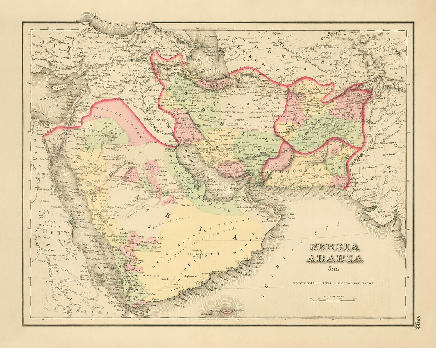
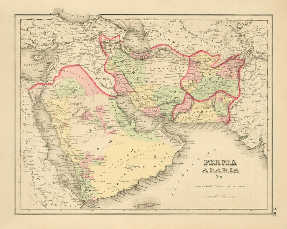


Ancienne carte de la Perse et de l'Arabie par Colton, 1857: Moyen-Orient, Golfe Persique, Montagnes Zagros
Achetez 2, obtenez 1 gratuit
Si vous ajoutez 2 articles à votre panier, vous pouvez ajouter un troisième produit gratuitement.
Cela fonctionne pour toutes les cartes et œuvres d'art, y compris les pièces personnalisées et sur mesure. Vous pouvez commander 3 de la même chose, ou 3 choses différentes.
Cela équivaut à une remise de 33 %, qui sera la plus grande remise disponible dans ma boutique cette année.
Veuillez profiter de l'offre et couvrir vos murs de belles cartes et œuvres d'art !
Contactez-moi si vous avez des questions.
- All taxes and duties included
- Handmade & dispatched in 1-2 days
-
FREE gift preview
ⓘ
Digital gift preview
After you complete your order, you can send a beautiful digital preview to the gift recipient. Just provide their email address and we'll do the rest. (Their email address will not be stored or used for any other purpose.)
This is perfect if you're concerned that your order might not arrive in time.
You can also buy a real non-expiring gift card, and email it directly to the recipient, so they can buy their own map or artwork.
-
90 day money back guarantee
ⓘ
90 jours pour retourner et obtenir un remboursement
Les produits peuvent être retournés dans les 90 jours pour un remboursement complet, ou un échange contre un autre produit.
Pour les articles personnalisés et faits sur mesure, nous pouvons vous offrir un crédit en magasin ou une carte-cadeau non expirante, car nous ne pouvons pas revendre les commandes personnalisées.
Si vous avez des questions, contactez-nous. Pour plus d'informations, consultez notre politique de retours et d'échanges.

My maps are rare, museum-grade, restored old maps sourced from libraries, auction houses and private collections across the globe.
Framing & free personalisation available
1. Select your size
Click here to order a custom size.
2. Frame & personalise your map
Make your map unique with framing, hand-drawn customisation, vintage ageing, pop art text, unique 3D styling and more.


Message cadeau & finition personnalisée

Si vous souhaitez ajouter un message cadeau, ou une finition (puzzle, panneau en aluminium, etc.) qui n'est pas disponible ici, veuillez le demander dans la "note de commande" lors de votre passage à la caisse.
Chaque commande est fabriquée sur mesure, donc si vous avez besoin d'ajuster légèrement la taille, ou d'imprimer sur un matériau inhabituel, faites-le nous savoir. Nous avons réalisé des milliers de commandes personnalisées au fil des ans, donc il n'y a (presque) rien que nous ne puissions gérer.
Vous pouvez également nous contacter avant de passer votre commande, si vous le souhaitez !

- Handmade locally. No import duty or tax
- FREE worldwide delivery
- Love it or your money back (90 days)
- Questions? WhatsApp me any time
Own a piece of history
5,000+ 5 star reviews


Entrez dans le monde complexe de la cartographie du 19ème siècle avec "Persia Arabia &c.," une œuvre maîtresse publiée en 1857 par le renommé Joseph Hutchins Colton. Cette carte exquise, produite à New York au sommet de la carrière de Colton, capture les vastes et énigmatiques paysages du Moyen-Orient, s'étendant du cœur de la Perse aux déserts balayants d'Arabie et aux rivages légendaires du Golfe Persique. La bordure décorative signature de Colton et ses délicates teintes pastel encadrent une région en mutation, offrant un rare aperçu d'une époque avant les bouleversements géopolitiques sismiques qui redéfiniraient ces terres dans les décennies suivantes.
Joseph Hutchins Colton était célébré pour son attention méticuleuse aux détails et à l'art, et cette carte est un témoignage de son héritage. Ses cartes n'étaient pas simplement des outils de navigation mais des artefacts culturels, conçus pour informer et inspirer. Ici, Colton rend les territoires de l'Empire ottoman, de la Perse, de l'Afghanistan et du Belouchistan avec une clarté remarquable, délimitant à la fois les frontières politiques et les caractéristiques physiques. L'étiquetage des régions telles qu'El Ahsa et El Hejer le long de la côte sud du Golfe reflète la nomenclature et les réalités administratives de l'époque, juste avant l'expansion ottomane dans l'est de l'Arabie.
Le détail géographique de la carte est aussi captivant que son contexte historique. Des chaînes de montagnes comme les rugged Zagros et Elburz sont gravées à travers la Perse, tandis que les vastes déserts et plaines côtières d'Arabie sont cartographiés avec précision. Les eaux scintillantes du Golfe Persique, du Golfe d'Oman et de la mer d'Arabie définissent les frontières maritimes de la région, parsemées de caractéristiques évocatrices telles que le Grand Banc de Perles, l'île de Goodwin et l'île de Dahnyi. Ces phénomènes naturels étaient d'une immense importance économique et culturelle, surtout alors que l'industrie perlière du Golfe prospérait au 19ème siècle.
Les villes et les villages sont méticuleusement tracés, beaucoup portant des noms qui résonnent à travers l'histoire et dans le monde moderne. De la métropole animée de Téhéran et des rues légendaires de Bagdad aux établissements émergents de Dibbah (Dubaï), Abothubbee (Abou Dabi) et Sharjas Tower (Sharjah), la carte retrace l'essor de centres urbains qui deviendraient plus tard des plaques tournantes mondiales. Dans le Golfe, des lieux comme Zabarah, El Katif et Bahrein sont mis en avant, tandis que des villes commerciales anciennes telles que Mascate, Sana et Mocha ancrent les confins sud de la péninsule arabique.
Ce qui distingue cette carte est sa capacité à capturer un moment charnière de l'histoire de la région - un carrefour d'empire, de commerce et de culture. Elle préserve la mémoire d'un paysage avant l'État-nation moderne, où les frontières étaient poreuses et les identités façonnées par la géographie autant que par la politique. Pour les collectionneurs et les connaisseurs, "Persia Arabia &c." n'est pas seulement un artefact visuellement époustouflant mais aussi une fenêtre sur l'interaction dynamique entre la terre, la mer et la société qui a défini le Moyen-Orient pendant des siècles.
Villes et villages sur cette carte
- Émirats Arabes Unis (aujourd'hui) :
- Dibbah (Dubaï)
- Abothubbee (Abou Dabi)
- Sharjas Tower (Sharjah)
- Ras al Khyme (Ras Al Khaimah)
- Arabie Saoudite (aujourd'hui) :
- El Katif (Al Qatif)
- El Ahsa (Al-Hasa/Al-Ahsa)
- Duat (probablement Dawhat, près du Qatar)
- El Hejer (Al-Hijr/Mada'in Salih)
- Qatar (aujourd'hui) :
- Zabarah (Al Zubarah)
- Ras Aufir (probablement Ras Laffan ou similaire)
- Bahrain (aujourd'hui) :
- Bahrein (Bahrain)
- Iran (Perse) :
- Téhéran (Tehran)
- Ispahan (Isfahan)
- Shiraz
- Tabriz
- Mashad (Mashhad)
- Yezd (Yazd)
- Kerman
- Bushire (Bushehr)
- Resht (Rasht)
- Hamadan
- Iraq (Empire ottoman à l'époque) :
- Bagdad (Baghdad)
- Bassora (Basra)
- Mosul
- Kerbela (Karbala)
- Hillah
- Afghanistan :
- Herat
- Kandahar
- Kaboul
- Balkh
- Pakistan (Beloutchistan) :
- Kelat (Kalat)
- Quetta
- Oman :
- Muscat
- Yémen :
- Sana (Sana'a)
- Mocha
Caractéristiques et monuments notables
- Gulf Persique (étiqueté comme tel)
- Gulf d'Oman
- Mer d'Arabie
- Mer Rouge
- Mer Caspienne (partiellement visible en haut)
- Contours des grands empires et régions : Empire ottoman, Perse, Afghanistan, Beloutchistan
- Frontières provinciales et régionales au sein de ces plus grandes entités
- Montagnes Zagros (en Perse/Iran)
- Montagnes Elbourz (au nord de la Perse/Iran)
- D'autres chaînes de montagnes en Afghanistan et le long de la péninsule arabique
- Bahrain (Bahreïn)
- Île de Goodwin
- Île de Dahnyi
- Le Grand Banc de Perles (étiqueté dans le Golfe près de Bahreïn/Qatar)
- Bord décoratif typique du style de Colton
Contexte historique et de design
- Nom de la carte : Perse Arabie &c.
- Cartographe/éditeur : Joseph Hutchins Colton, un cartographe américain du 19ème siècle connu pour ses cartes détaillées et décoratives, publiées à New York.
- Date de création : 1857.
- La carte est centrée sur la péninsule arabique et le golfe Persique, et inclut également l'empire ottoman, la Perse (Iran moderne), l'Afghanistan, le Beloutchistan (Balochistan) et les régions adjacentes.
- La carte est à la fois une carte politique et physique, montrant les frontières, les provinces et les caractéristiques physiques telles que les chaînes de montagnes et les plans d'eau.
- La carte précède l'expédition d'Al-Hasa de 1871, qui a conduit l'empire ottoman à étendre son influence sur la péninsule arabique orientale (région d'El Ahsa/El Hejer).
- La côte sud du Golfe est étiquetée comme El Ahsa ou El Hejer, reflétant la nomenclature de l'époque avant les changements administratifs ottomans.
- Des formes précoces de noms pour les émirats des Émirats arabes unis d'aujourd'hui, tels que Tour de Sharjas (Sharjah), Dibbah (Dubaï), Abothubbee (Abou Dabi) et Ras al Khyme (Ras Al Khaimah), sont montrées.
- Près du Qatar et de Bahreïn, des caractéristiques telles que Ras Aufir, Zabarah, El Katif, Duat, le Grand Banc de Perles, l'île de Goodwin et l'île de Dahnyi sont montrées.
- La carte fournit un aperçu des connaissances politiques et géographiques de la région au milieu du 19ème siècle, avant les grands changements géopolitiques tels que l'expansion de l'empire ottoman dans l'Arabie orientale.
Veuillez vérifier les images pour vous assurer qu'une ville ou un lieu spécifique est représenté sur cette carte. Vous pouvez également nous contacter et nous demander de vérifier la carte pour vous.
Cette carte a fière allure à toutes les tailles, mais je recommande toujours d'opter pour une taille plus grande si vous avez de l'espace. De cette façon, vous pouvez facilement distinguer tous les détails.
Cette carte est incroyable à des tailles allant jusqu'à 70 pouces (180 cm). Si vous recherchez une carte plus grande, veuillez nous contacter.
Le modèle dans les images de la liste tient la version 16x20 pouces (40x50 cm) de cette carte.
La cinquième image de la liste montre un exemple de mon service de personnalisation de carte.
Si vous recherchez quelque chose d'un peu différent, consultez ma collection des meilleures anciennes cartes pour voir si quelque chose d'autre attire votre attention.
Veuillez me contacter pour vérifier si un certain emplacement, un monument ou une caractéristique est représenté sur cette carte.
Cela ferait un merveilleux cadeau d'anniversaire, de Noël, pour la fête des pères, un départ au travail, un anniversaire de mariage ou une pendaison de crémaillère pour quelqu'un des régions couvertes par cette carte.
Cette carte est disponible en tant qu'impression giclée sur papier mat d'archivage sans acide, ou vous pouvez l'acheter encadrée. Le cadre est un joli cadre noir simple qui convient à la plupart des esthétiques. Veuillez me contacter si vous souhaitez une couleur ou un matériau de cadre différent. Mes cadres sont vitrifiés avec un acrylique de musée super clair (perspex/acrylite), qui est significativement moins réfléchissant que le verre, plus sûr, et arrivera toujours en parfait état.
This map is also available as a float framed canvas, sometimes known as a shadow gap framed canvas or canvas floater. The map is printed on artist's cotton canvas and then stretched over a handmade box frame. We then "float" the canvas inside a wooden frame, which is available in a range of colours (black, dark brown, oak, antique gold and white). This is a wonderful way to present a map without glazing in front. See some examples of float framed canvas maps and explore the differences between my different finishes.
For something truly unique, this map is also available in "Unique 3D", our trademarked process that dramatically transforms the map so that it has a wonderful sense of depth. We combine the original map with detailed topography and elevation data, so that mountains and the terrain really "pop". For more info and examples of 3D maps, check my Unique 3D page.
Pour la plupart des commandes, le délai de livraison est d'environ 3 jours ouvrables. Les produits personnalisés et sur mesure prennent plus de temps, car je dois faire la personnalisation et vous l'envoyer pour approbation, ce qui prend généralement 1 ou 2 jours.
Veuillez noter que les grandes commandes encadrées prennent généralement plus de temps à réaliser et à livrer.
Si vous avez besoin que votre commande arrive à une date précise, veuillez me contacter avant de passer votre commande afin que nous puissions trouver le meilleur moyen de nous assurer que vous receviez votre commande à temps.
J'imprime et encadre des cartes et des œuvres d'art dans 23 pays à travers le monde. Cela signifie que votre commande sera réalisée localement, ce qui réduit le temps de livraison et garantit qu'elle ne sera pas endommagée pendant le transport. Vous ne paierez jamais de droits de douane ou d'importation, et nous mettrons moins de CO2 dans l'air.
Toutes mes cartes et impressions artistiques sont bien emballées et envoyées dans un tube robuste si non encadrées, ou entourées de mousse si encadrées.
J'essaie d'envoyer toutes les commandes dans les 1 ou 2 jours suivant la réception de votre commande, bien que certains produits (comme les masques, les mugs et les sacs fourre-tout) puissent prendre plus de temps à réaliser.
Si vous choisissez Livraison Express lors du paiement, nous donnerons la priorité à votre commande et l'enverrons par un service de messagerie de 1 jour (Fedex, DHL, UPS, Parcelforce).
La livraison le lendemain est également disponible dans certains pays (États-Unis, Royaume-Uni, Singapour, Émirats Arabes Unis), mais veuillez essayer de commander tôt dans la journée afin que nous puissions l'envoyer à temps.
Lisez mon guide complet sur la livraison et la production locale
Mon cadre standard est un cadre en bois dur noir de style galerie. Il est simple et a un aspect assez moderne. Mon cadre standard mesure environ 20 mm (0,8 po) de large.
J'utilise de l'acrylique super clair (perspex/acrylite) pour le verre du cadre. C'est plus léger et plus sûr que le verre - et cela a meilleur aspect, car la réflexivité est plus faible.
Six couleurs de cadre standard sont disponibles gratuitement (noir, marron foncé, gris foncé, chêne, blanc et or antique). Des encadrements et montages/matelassages personnalisés sont disponibles si vous recherchez autre chose.
La plupart des cartes, œuvres d'art et illustrations sont également disponibles sous forme de toile encadrée. Nous utilisons une toile en coton mate (non brillante), que nous tendons sur un cadre en bois de boîte provenant de sources durables, puis nous 'flottions' la pièce à l'intérieur d'un cadre en bois. Le résultat final est assez beau, et il n'y a pas de vitrage qui gêne.
Tous les cadres sont fournis "prêts à accrocher", avec soit une corde, soit des supports à l'arrière. Les très grands cadres auront des plaques de suspension lourdes et/ou une latte de montage. Si vous avez des questions, veuillez nous contacter.
Voir quelques exemples de mes cartes encadrées et de cartes en toile encadrées.
Alternativement, je peux également fournir de vieilles cartes et œuvres d'art sur toile, sur panneau en mousse, en coton et d'autres matériaux.
Si vous souhaitez encadrer votre carte ou œuvre d'art vous-même, veuillez lire d'abord mon guide des tailles.
Certaines de mes anciennes cartes sont maintenant disponibles en tant que toiles encadrées. Veuillez me contacter si vous souhaitez commander une taille qui n'est pas disponible dans ma boutique.
Les anciennes cartes en toile sont une alternative intéressante aux cartes encadrées de manière conventionnelle. Selon vos goûts personnels et la décoration de votre pièce, les cartes en toile peuvent "se démarquer" un peu plus qu'une carte encadrée.
Mes cartes sont des reproductions de cartes originales de très haute qualité.
Je recherche des cartes originales et rares auprès de bibliothèques, de maisons de ventes aux enchères et de collections privées du monde entier, je les restaure dans mon atelier de Londres, puis j'utilise des encres et des imprimantes giclées spécialisées pour créer de magnifiques cartes encore plus belles que l'originale.
Mes cartes sont imprimées sur du papier d’archives mat (non brillant) sans acide qui semble de très haute qualité et ressemble presque à une carte. En termes techniques, le grammage/épaisseur du papier est de 10 mil/200 g/m². C'est parfait pour l'encadrement.
J’imprime avec des encres pigmentaires Epson ultrachrome giclée UV résistantes à la décoloration – certaines des meilleures encres que vous puissiez trouver.
je peux aussi faire cartes sur toile, chiffon en coton et autres matériaux exotiques.
En savoir plus sur Unique Maps Co..
Personnalisation de la carte
Si vous recherchez le cadeau parfait pour un anniversaire ou une pendaison de crémaillère, je peux personnaliser votre carte pour la rendre vraiment unique. Par exemple, je peux ajouter un court message, mettre en évidence un lieu important ou ajouter les armoiries de votre famille.
Les options sont presque infinies. S'il vous plaît voir mon page de personnalisation de la carte pour quelques merveilleux exemples de ce qui est possible.
Pour commander une carte personnalisée, sélectionnez « personnaliser votre carte » avant de l'ajouter à votre panier.
Entrer en contact si vous recherchez des personnalisations et des personnalisations plus complexes.
Vieillissement de la carte
Au fil des ans, des clients m'ont demandé des centaines de fois s'ils pouvaient acheter une carte qui semble uniforme. plus vieux.
Eh bien, vous pouvez désormais le faire en sélectionnant Aged avant d'ajouter une carte à votre panier.
Toutes les photos de produits que vous voyez sur cette page montrent la carte dans sa forme originale. Voilà à quoi ressemble la carte aujourd'hui.
Si vous sélectionnez Vieilli, je vieillirai votre carte à la main, en utilisant un processus spécial et unique développé au cours d'années d'étude de cartes anciennes, de discussions avec des chercheurs pour comprendre la chimie du vieillissement du papier, et bien sûr... beaucoup de pratique !
Si vous n'êtes pas sûr, respectez la couleur originale de la carte. Si vous voulez quelque chose d'un peu plus sombre et plus vieux à la recherche, optez pour Aged.
Si vous n'êtes pas satisfait de votre commande pour une raison quelconque, contactez-moi pour un remboursement sans conditions. Veuillez consulter notre politique de retours et de remboursements pour plus d'informations.
Je suis très confiant que vous aimerez votre carte restaurée ou votre impression artistique. Je fais cela depuis 1984. Je suis un vendeur Etsy 5 étoiles. J'ai vendu des dizaines de milliers de cartes et d'impressions artistiques et j'ai plus de 5 000 vrais avis 5 étoiles.
J'utilise un processus unique pour restaurer des cartes et des œuvres d'art qui est extrêmement chronophage et exigeant en main-d'œuvre. Trouver les cartes et illustrations originales peut prendre des mois. J'utilise une technologie de pointe et incroyablement coûteuse pour les numériser et les restaurer. En conséquence, je garantis que mes cartes et impressions artistiques sont d'une qualité supérieure - c'est pourquoi je peux offrir un remboursement sans conditions.
Presque toutes mes cartes et impressions artistiques ont l'air incroyables en grandes tailles (200 cm, 6,5 pieds+) et je peux également les encadrer et vous les livrer, via un transporteur spécial surdimensionné. Contactez-moi pour discuter de vos besoins spécifiques.
Or try searching for something!


