


Carte picturale de la route aérienne de Los Angeles à Catalina, 1929: Western Air Express, Casino Resort, Fokker tri-moteur, Santa Monica, Pasadena
L’offre du collectionneur
Choisissez deux œuvres éligibles et bénéficiez de 20 % de réduction sur les deux. Choisissez-en trois et celle au prix le plus bas est offerte, pour une économie maximale de 33 %.
Associez librement des cartes standard éligibles et des tirages d’art. Aucun code n’est requis ; l’offre est appliquée automatiquement lors du paiement.
Les configurations standard réalisées sur commande sont incluses. Les formats sur mesure, les créations personnalisées et les œuvres commissionnées sont exclus.
Besoin d’une livraison à différentes adresses ? Contactez-nous avant de commander.L’offre du collectionneur
Choisissez deux œuvres éligibles et bénéficiez de 20 % de réduction sur les deux. Choisissez-en trois et celle au prix le plus bas est offerte, pour une économie maximale de 33 %.
Associez librement des cartes standard éligibles et des tirages d’art. Aucun code n’est requis ; l’offre est appliquée automatiquement lors du paiement.
Les configurations standard réalisées sur commande sont incluses. Les formats sur mesure, les créations personnalisées et les œuvres commissionnées sont exclus.
Besoin d’une livraison à différentes adresses ? Contactez-nous avant de commander.
Restaurée à partir de la carte originale de 1929 et imprimée en qualité musée. Lire l’histoire de cette carte
Choose your size
Choose your finish


(Plus d’infos)
Message cadeau & finition personnalisée

Si vous souhaitez ajouter un message cadeau, ou une finition (puzzle, panneau en aluminium, etc.) qui n'est pas disponible ici, veuillez le demander dans la "note de commande" lors de votre passage à la caisse.
Chaque commande est fabriquée sur mesure, donc si vous avez besoin d'ajuster légèrement la taille, ou d'imprimer sur un matériau inhabituel, faites-le nous savoir. Nous avons réalisé des milliers de commandes personnalisées au fil des ans, donc il n'y a (presque) rien que nous ne puissions gérer.
Vous pouvez également nous contacter avant de passer votre commande, si vous le souhaitez !

- Fabriqué localement. Livraison sûre
- Sans droits ni frais cachés
- Besoin d’aide ? Appelez-nous ou message WhatsApp
Own a piece of history
8,000+ five-star reviews


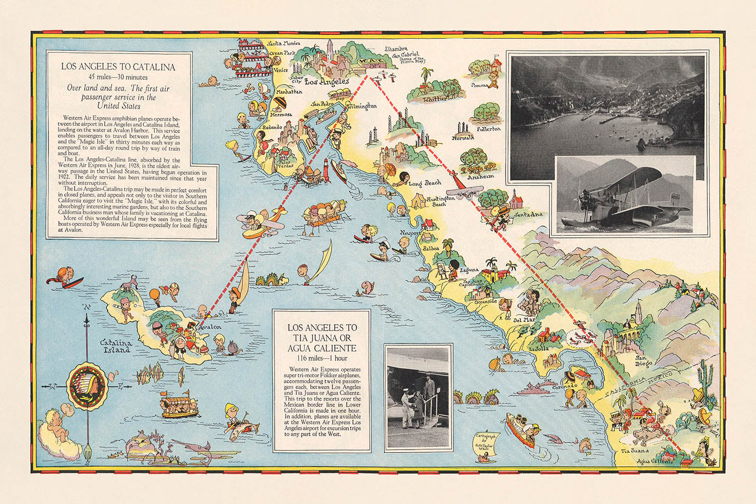
Entrez dans l'âge d'or de l'aviation avec cette magnifique carte picturale de 1929, « Los Angeles à Tia Juana ou Agua Caliente....
Continuer la lectureEntrez dans l'âge d'or de l'aviation avec cette magnifique carte picturale de 1929, « Los Angeles à Tia Juana ou Agua Caliente. Los Angeles à Catalina, » magistralement illustrée par Ruth Taylor White pour Western Air Express. Créée à un moment charnière de l'histoire des voyages, cette carte non seulement trace les routes aériennes naissantes reliant le sud de la Californie aux destinations de loisirs en plein essor de Baja California et de l'île de Catalina, mais encapsule également l'optimisme et l'excitation des premiers vols commerciaux. Le style signature de White—vif, fantaisiste et très détaillé—donne vie aux paysages, aux villes et aux lieux de loisirs qui ont défini cette époque de transformation rapide.
Le récit visuel de la carte est à la fois pratique et enchanteur. Les principales routes aériennes sont élégamment tracées, avec des notations claires des distances et des temps de vol—comme le rapide voyage d'une heure de Los Angeles à Tia Juana (aujourd'hui Tijuana) ou Agua Caliente, et le saut de 30 minutes vers l'île de Catalina. Le long de ces chemins, le spectateur est traité à des représentations picturales des avions Fokker à trois moteurs s'élevant au-dessus des montagnes escarpées, des villes animées et des côtes tranquilles. Chaque détail sert à la fois d'aide à la navigation et d'invitation à l'aventure, reflétant la fascination de l'époque pour la vitesse, le confort et la nouvelle accessibilité des destinations lointaines.
Au-delà de son utilité pratique, cette carte est une célébration de la vitalité culturelle et récréative du sud de la Californie et du nord de Baja California à la fin des années 1920. Elle met en avant une constellation de villes—Los Angeles, San Diego, Santa Monica, Pasadena, et d'autres—chacune représentée avec une architecture iconique et des scènes de rue animées. Les régions sud de la carte présentent le légendaire complexe hôtelier d'Agua Caliente, célèbre pour son casino et ses hébergements luxueux, et Tia Juana, une destination synonyme d'excitation et de divertissement transfrontaliers. L'île de Catalina, quant à elle, est dépeinte comme un paradis de navigation, de plages et de loisirs, capturant l'esprit d'une époque où le voyage lui-même était un événement.
L'art de Ruth Taylor White s'étend aux illustrations animées de la carte représentant des personnes en train de s'amuser—golfeurs, cavaliers, baigneurs et touristes—tous sur fond de fermes, de forêts et de centres industriels. La frontière entre les États-Unis et le Mexique est clairement marquée, soulignant l'attrait international de ces routes aériennes et les aspirations cosmopolites des voyageurs de l'époque. Ce mélange de cartographie pratique et d'illustration imaginative guide non seulement le voyageur mais l'invite également à rêver, faisant de la carte un artefact précieux à la fois de l'histoire de l'aviation et du design graphique.
Historiquement, cette carte se dresse comme un témoignage du pouvoir transformateur de l'aviation au début du 20ème siècle. Elle reflète comment des compagnies aériennes comme Western Air Express ont commercialisé le voyage aérien comme une expérience luxueuse, fiable et moderne—une éthique capturée dans chaque détail de la composition de la carte. Pour les collectionneurs, les historiens ou quiconque passionné par le romantisme des premiers vols, cette carte offre une fenêtre rare et évocatrice sur un monde où les cieux s'ouvraient, et chaque voyage promettait découverte, confort et une touche de glamour.
Les lieux sur cette carte
- Los Angeles
- Île de Catalina
- Tia Juana (Tijuana)
- Agua Caliente
- Long Beach
- San Pedro
- Santa Ana
- San Diego
- Oceanside
- Riverside
- San Bernardino
- Redlands
- Pomona
- Pasadena
- Santa Monica
- Whittier
- Fullerton
- Anaheim
- Laguna Beach
- Newport Beach
Caractéristiques et monuments notables
- Itinéraires aériens clairement marqués de Los Angeles à Tia Juana (Tijuana)/Agua Caliente et vers l'île de Catalina
- Illustration d'un avion Fokker à trois moteurs volant au-dessus du paysage
- Logo en forme de flèche de Western Air Express
- Représentations picturales de montagnes, rivières et forêts
- Activités récréatives représentées, telles que le golf, l'équitation et la navigation
- Attractions touristiques, y compris les plages et les stations
- Zones industrielles et fermes illustrées le long de la route
- Principales autoroutes et routes montrées reliant les villes et villages
- Temps de vol et distances étiquetés : 116 miles/1 heure jusqu'à Tia Juana ou Agua Caliente, 45 miles/30 minutes jusqu'à Catalina
- Frontière entre les États-Unis et le Mexique clairement indiquée
- Relief pictural montrant la topographie et les caractéristiques du paysage
- Villes et villages étiquetés le long des itinéraires aériens
- Illustrations de personnes participant à des sports et à des activités de loisirs
- Île de Catalina représentée avec des bateaux et des scènes récréatives
- Zone de loisirs d'Agua Caliente illustrée avec des images de casino et d'hôtel
- Los Angeles montré comme un important centre urbain avec des bâtiments proéminents
- Tia Juana (Tijuana) représentée avec une architecture locale distinctive
- Trajectoires de vol d'avion visuellement tracées sur la carte
- Notations des distances entre les points clés
- Cadre décoratif et cartouche de titre dans le style de l'époque
Contexte historique et de conception
- Créé en octobre 1929 par Ruth Taylor White pour Western Air Express, une compagnie aérienne pionnière
- Ruth Taylor White était connue pour ses cartes picturales colorées et fantaisistes qui mêlaient art et informations pratiques sur les voyages
- Conçu comme un guide promotionnel et informatif pour les voyageurs, mettant en avant la commodité et l'aventure des premiers voyages aériens
- Réflecte le développement rapide de l'aviation commerciale aux États-Unis à la fin des années 1920
- Met en avant l'attrait des voyages rapides vers des lieux de vacances comme l'île de Catalina et Agua Caliente, une célèbre destination de station et de casino à Baja California
- Le style de la carte est pictural et thématique, avec un relief représenté visuellement plutôt que topographiquement
- Constitue un artefact précieux pour comprendre l'intersection du transport, du tourisme et du design graphique au début du XXe siècle en Amérique
- Met l'accent sur la fiabilité et la modernité de Western Air Express, avec un marketing axé sur "Vitesse - Confort - Fiabilité"
- Fournit un aperçu des destinations populaires et des activités de loisirs de l'époque
- Célèbre la vitalité culturelle et récréative du sud de la Californie et du nord de Baja California à la fin des années 1920
Veuillez vérifier les images pour vous assurer qu'une ville ou un lieu spécifique est montré sur cette carte. Vous pouvez également nous contacter et nous demander de vérifier la carte pour vous.
Cette carte a fière allure à toutes les tailles, mais je recommande toujours d'opter pour une taille plus grande si vous avez de l'espace. De cette façon, vous pouvez facilement distinguer tous les détails.
Cette carte est incroyable à des tailles allant jusqu'à 70 pouces (180 cm). Si vous recherchez une carte plus grande, veuillez nous contacter.
Le modèle sur les images de la liste tient la version 24x36 pouces (60x90 cm) de cette carte.
La cinquième image de la liste montre un exemple de mon service de personnalisation de carte.
Si vous cherchez quelque chose de légèrement différent, consultez ma collection des meilleurs vieux cartes pour voir si quelque chose d'autre attire votre attention.
Veuillez me contacter pour vérifier si un certain endroit, monument ou caractéristique est représenté sur cette carte.
Cela ferait un merveilleux cadeau d'anniversaire, de Noël, de la fête des pères, de départ au travail, d'anniversaire de mariage ou de crémaillère pour quelqu'un des régions couvertes par cette carte.
Cette carte est disponible en tant qu'impression giclée sur papier mat d'archivage sans acide, ou vous pouvez l'acheter encadrée. Le cadre est un joli cadre noir simple qui convient à la plupart des esthétiques. Veuillez me contacter si vous souhaitez une couleur ou un matériau de cadre différent. Mes cadres sont vitrifiés avec un acrylique de musée super clair (perspex/acrylite), qui est significativement moins réfléchissant que le verre, plus sûr et arrivera toujours en parfait état.
This map is also available as a float framed canvas, sometimes known as a shadow gap framed canvas or canvas floater. The map is printed on artist's cotton canvas and then stretched over a handmade box frame. We then "float" the canvas inside a wooden frame, which is available in a range of colours (black, dark brown, oak, antique gold and white). This is a wonderful way to present a map without glazing in front. See some examples of float framed canvas maps and explore the differences between my different finishes.
For something truly unique, this map is also available in "Unique 3D", our trademarked process that dramatically transforms the map so that it has a wonderful sense of depth. We combine the original map with detailed topography and elevation data, so that mountains and the terrain really "pop". For more info and examples of 3D maps, check my Unique 3D page.
Entrez dans l'âge d'or de l'aviation avec cette magnifique carte picturale de 1929, « Los Angeles à Tia Juana ou Agua Caliente. Los Angeles à Catalina, » magistralement illustrée par Ruth Taylor White pour Western Air Express. Créée à un moment charnière de l'histoire des voyages, cette carte non seulement trace les routes aériennes naissantes reliant le sud de la Californie aux destinations de loisirs en plein essor de Baja California et de l'île de Catalina, mais encapsule également l'optimisme et l'excitation des premiers vols commerciaux. Le style signature de White—vif, fantaisiste et très détaillé—donne vie aux paysages, aux villes et aux lieux de loisirs qui ont défini cette époque de transformation rapide.
Le récit visuel de la carte est à la fois pratique et enchanteur. Les principales routes aériennes sont élégamment tracées, avec des notations claires des distances et des temps de vol—comme le rapide voyage d'une heure de Los Angeles à Tia Juana (aujourd'hui Tijuana) ou Agua Caliente, et le saut de 30 minutes vers l'île de Catalina. Le long de ces chemins, le spectateur est traité à des représentations picturales des avions Fokker à trois moteurs s'élevant au-dessus des montagnes escarpées, des villes animées et des côtes tranquilles. Chaque détail sert à la fois d'aide à la navigation et d'invitation à l'aventure, reflétant la fascination de l'époque pour la vitesse, le confort et la nouvelle accessibilité des destinations lointaines.
Au-delà de son utilité pratique, cette carte est une célébration de la vitalité culturelle et récréative du sud de la Californie et du nord de Baja California à la fin des années 1920. Elle met en avant une constellation de villes—Los Angeles, San Diego, Santa Monica, Pasadena, et d'autres—chacune représentée avec une architecture iconique et des scènes de rue animées. Les régions sud de la carte présentent le légendaire complexe hôtelier d'Agua Caliente, célèbre pour son casino et ses hébergements luxueux, et Tia Juana, une destination synonyme d'excitation et de divertissement transfrontaliers. L'île de Catalina, quant à elle, est dépeinte comme un paradis de navigation, de plages et de loisirs, capturant l'esprit d'une époque où le voyage lui-même était un événement.
L'art de Ruth Taylor White s'étend aux illustrations animées de la carte représentant des personnes en train de s'amuser—golfeurs, cavaliers, baigneurs et touristes—tous sur fond de fermes, de forêts et de centres industriels. La frontière entre les États-Unis et le Mexique est clairement marquée, soulignant l'attrait international de ces routes aériennes et les aspirations cosmopolites des voyageurs de l'époque. Ce mélange de cartographie pratique et d'illustration imaginative guide non seulement le voyageur mais l'invite également à rêver, faisant de la carte un artefact précieux à la fois de l'histoire de l'aviation et du design graphique.
Historiquement, cette carte se dresse comme un témoignage du pouvoir transformateur de l'aviation au début du 20ème siècle. Elle reflète comment des compagnies aériennes comme Western Air Express ont commercialisé le voyage aérien comme une expérience luxueuse, fiable et moderne—une éthique capturée dans chaque détail de la composition de la carte. Pour les collectionneurs, les historiens ou quiconque passionné par le romantisme des premiers vols, cette carte offre une fenêtre rare et évocatrice sur un monde où les cieux s'ouvraient, et chaque voyage promettait découverte, confort et une touche de glamour.
Les lieux sur cette carte
- Los Angeles
- Île de Catalina
- Tia Juana (Tijuana)
- Agua Caliente
- Long Beach
- San Pedro
- Santa Ana
- San Diego
- Oceanside
- Riverside
- San Bernardino
- Redlands
- Pomona
- Pasadena
- Santa Monica
- Whittier
- Fullerton
- Anaheim
- Laguna Beach
- Newport Beach
Caractéristiques et monuments notables
- Itinéraires aériens clairement marqués de Los Angeles à Tia Juana (Tijuana)/Agua Caliente et vers l'île de Catalina
- Illustration d'un avion Fokker à trois moteurs volant au-dessus du paysage
- Logo en forme de flèche de Western Air Express
- Représentations picturales de montagnes, rivières et forêts
- Activités récréatives représentées, telles que le golf, l'équitation et la navigation
- Attractions touristiques, y compris les plages et les stations
- Zones industrielles et fermes illustrées le long de la route
- Principales autoroutes et routes montrées reliant les villes et villages
- Temps de vol et distances étiquetés : 116 miles/1 heure jusqu'à Tia Juana ou Agua Caliente, 45 miles/30 minutes jusqu'à Catalina
- Frontière entre les États-Unis et le Mexique clairement indiquée
- Relief pictural montrant la topographie et les caractéristiques du paysage
- Villes et villages étiquetés le long des itinéraires aériens
- Illustrations de personnes participant à des sports et à des activités de loisirs
- Île de Catalina représentée avec des bateaux et des scènes récréatives
- Zone de loisirs d'Agua Caliente illustrée avec des images de casino et d'hôtel
- Los Angeles montré comme un important centre urbain avec des bâtiments proéminents
- Tia Juana (Tijuana) représentée avec une architecture locale distinctive
- Trajectoires de vol d'avion visuellement tracées sur la carte
- Notations des distances entre les points clés
- Cadre décoratif et cartouche de titre dans le style de l'époque
Contexte historique et de conception
- Créé en octobre 1929 par Ruth Taylor White pour Western Air Express, une compagnie aérienne pionnière
- Ruth Taylor White était connue pour ses cartes picturales colorées et fantaisistes qui mêlaient art et informations pratiques sur les voyages
- Conçu comme un guide promotionnel et informatif pour les voyageurs, mettant en avant la commodité et l'aventure des premiers voyages aériens
- Réflecte le développement rapide de l'aviation commerciale aux États-Unis à la fin des années 1920
- Met en avant l'attrait des voyages rapides vers des lieux de vacances comme l'île de Catalina et Agua Caliente, une célèbre destination de station et de casino à Baja California
- Le style de la carte est pictural et thématique, avec un relief représenté visuellement plutôt que topographiquement
- Constitue un artefact précieux pour comprendre l'intersection du transport, du tourisme et du design graphique au début du XXe siècle en Amérique
- Met l'accent sur la fiabilité et la modernité de Western Air Express, avec un marketing axé sur "Vitesse - Confort - Fiabilité"
- Fournit un aperçu des destinations populaires et des activités de loisirs de l'époque
- Célèbre la vitalité culturelle et récréative du sud de la Californie et du nord de Baja California à la fin des années 1920
Veuillez vérifier les images pour vous assurer qu'une ville ou un lieu spécifique est montré sur cette carte. Vous pouvez également nous contacter et nous demander de vérifier la carte pour vous.
Cette carte a fière allure à toutes les tailles, mais je recommande toujours d'opter pour une taille plus grande si vous avez de l'espace. De cette façon, vous pouvez facilement distinguer tous les détails.
Cette carte est incroyable à des tailles allant jusqu'à 70 pouces (180 cm). Si vous recherchez une carte plus grande, veuillez nous contacter.
Le modèle sur les images de la liste tient la version 24x36 pouces (60x90 cm) de cette carte.
La cinquième image de la liste montre un exemple de mon service de personnalisation de carte.
Si vous cherchez quelque chose de légèrement différent, consultez ma collection des meilleurs vieux cartes pour voir si quelque chose d'autre attire votre attention.
Veuillez me contacter pour vérifier si un certain endroit, monument ou caractéristique est représenté sur cette carte.
Cela ferait un merveilleux cadeau d'anniversaire, de Noël, de la fête des pères, de départ au travail, d'anniversaire de mariage ou de crémaillère pour quelqu'un des régions couvertes par cette carte.
Cette carte est disponible en tant qu'impression giclée sur papier mat d'archivage sans acide, ou vous pouvez l'acheter encadrée. Le cadre est un joli cadre noir simple qui convient à la plupart des esthétiques. Veuillez me contacter si vous souhaitez une couleur ou un matériau de cadre différent. Mes cadres sont vitrifiés avec un acrylique de musée super clair (perspex/acrylite), qui est significativement moins réfléchissant que le verre, plus sûr et arrivera toujours en parfait état.
This map is also available as a float framed canvas, sometimes known as a shadow gap framed canvas or canvas floater. The map is printed on artist's cotton canvas and then stretched over a handmade box frame. We then "float" the canvas inside a wooden frame, which is available in a range of colours (black, dark brown, oak, antique gold and white). This is a wonderful way to present a map without glazing in front. See some examples of float framed canvas maps and explore the differences between my different finishes.
For something truly unique, this map is also available in "Unique 3D", our trademarked process that dramatically transforms the map so that it has a wonderful sense of depth. We combine the original map with detailed topography and elevation data, so that mountains and the terrain really "pop". For more info and examples of 3D maps, check my Unique 3D page.
Many of our maps and art prints are chosen as thoughtful gifts for homes, offices, studies and meaningful places.
Choose a framed option for the easiest ready-to-hang gift, or choose an unframed print if the recipient may prefer to select their own frame.
We make orders locally in 23 countries around the world, so gifts can often be produced close to the recipient. This helps them arrive faster, travel more safely, and avoid customs or import duty surprises.
- We can deliver directly to the recipient
- Framed pieces arrive ready to hang
- Unframed prints are carefully packed in a strong protective tube
- Almost every order is made locally, for faster, safer gifting
- 90-day returns give the recipient time to decide
If you are not sure what to choose, please contact us. We can help you pick the right map, size, finish or delivery option.
Pour la plupart des commandes, le délai de livraison est d'environ 3 jours ouvrables. Les produits personnalisés et sur mesure prennent plus de temps, car je dois faire la personnalisation et vous l'envoyer pour approbation, ce qui prend généralement 1 ou 2 jours.
Veuillez noter que les grandes commandes encadrées prennent généralement plus de temps à réaliser et à livrer.
Si vous avez besoin que votre commande arrive à une date précise, veuillez me contacter avant de passer votre commande afin que nous puissions trouver le meilleur moyen de nous assurer que vous receviez votre commande à temps.
J'imprime et encadre des cartes et des œuvres d'art dans 23 pays à travers le monde. Cela signifie que votre commande sera réalisée localement, ce qui réduit le temps de livraison et garantit qu'elle ne sera pas endommagée pendant le transport. Vous ne paierez jamais de droits de douane ou d'importation, et nous mettrons moins de CO2 dans l'air.
Toutes mes cartes et impressions artistiques sont bien emballées et envoyées dans un tube robuste si non encadrées, ou entourées de mousse si encadrées.
J'essaie d'envoyer toutes les commandes dans les 1 ou 2 jours suivant la réception de votre commande, bien que certains produits (comme les masques, les mugs et les sacs fourre-tout) puissent prendre plus de temps à réaliser.
Si vous choisissez Livraison Express lors du paiement, nous donnerons la priorité à votre commande et l'enverrons par un service de messagerie de 1 jour (Fedex, DHL, UPS, Parcelforce).
La livraison le lendemain est également disponible dans certains pays (États-Unis, Royaume-Uni, Singapour, Émirats Arabes Unis), mais veuillez essayer de commander tôt dans la journée afin que nous puissions l'envoyer à temps.
Lisez mon guide complet sur la livraison et la production locale
Mon cadre standard est un cadre en bois dur noir de style galerie. Il est simple et a un aspect assez moderne. Mon cadre standard mesure environ 20 mm (0,8 po) de large.
J'utilise de l'acrylique super clair (perspex/acrylite) pour le verre du cadre. C'est plus léger et plus sûr que le verre - et cela a meilleur aspect, car la réflexivité est plus faible.
Six couleurs de cadre standard sont disponibles gratuitement (noir, marron foncé, gris foncé, chêne, blanc et or antique). Des encadrements et montages/matelassages personnalisés sont disponibles si vous recherchez autre chose.
La plupart des cartes, œuvres d'art et illustrations sont également disponibles sous forme de toile encadrée. Nous utilisons une toile en coton mate (non brillante), que nous tendons sur un cadre en bois de boîte provenant de sources durables, puis nous 'flottions' la pièce à l'intérieur d'un cadre en bois. Le résultat final est assez beau, et il n'y a pas de vitrage qui gêne.
Tous les cadres sont fournis "prêts à accrocher", avec soit une corde, soit des supports à l'arrière. Les très grands cadres auront des plaques de suspension lourdes et/ou une latte de montage. Si vous avez des questions, veuillez nous contacter.
Voir quelques exemples de mes cartes encadrées et de cartes en toile encadrées.
Alternativement, je peux également fournir de vieilles cartes et œuvres d'art sur toile, sur panneau en mousse, en coton et d'autres matériaux.
Si vous souhaitez encadrer votre carte ou œuvre d'art vous-même, veuillez lire d'abord mon guide des tailles.
Mes cartes sont des reproductions de cartes originales de très haute qualité.
Je recherche des cartes originales et rares auprès de bibliothèques, de maisons de ventes aux enchères et de collections privées du monde entier, je les restaure dans mon atelier de Londres, puis j'utilise des encres et des imprimantes giclées spécialisées pour créer de magnifiques cartes encore plus belles que l'originale.
Mes cartes sont imprimées sur du papier d’archives mat (non brillant) sans acide qui semble de très haute qualité et ressemble presque à une carte. En termes techniques, le grammage/épaisseur du papier est de 10 mil/200 g/m². C'est parfait pour l'encadrement.
J’imprime avec des encres pigmentaires Epson ultrachrome giclée UV résistantes à la décoloration – certaines des meilleures encres que vous puissiez trouver.
je peux aussi faire cartes sur toile, chiffon en coton et autres matériaux exotiques.
En savoir plus sur Unique Maps Co..
Personnalisation de la carte
Si vous recherchez le cadeau parfait pour un anniversaire ou une pendaison de crémaillère, je peux personnaliser votre carte pour la rendre vraiment unique. Par exemple, je peux ajouter un court message, mettre en évidence un lieu important ou ajouter les armoiries de votre famille.
Les options sont presque infinies. S'il vous plaît voir mon page de personnalisation de la carte pour quelques merveilleux exemples de ce qui est possible.
Pour commander une carte personnalisée, sélectionnez « personnaliser votre carte » avant de l'ajouter à votre panier.
Entrer en contact si vous recherchez des personnalisations et des personnalisations plus complexes.
Vieillissement de la carte
Au fil des ans, des clients m'ont demandé des centaines de fois s'ils pouvaient acheter une carte qui semble uniforme. plus vieux.
Eh bien, vous pouvez désormais le faire en sélectionnant Aged avant d'ajouter une carte à votre panier.
Toutes les photos de produits que vous voyez sur cette page montrent la carte dans sa forme originale. Voilà à quoi ressemble la carte aujourd'hui.
Si vous sélectionnez Vieilli, je vieillirai votre carte à la main, en utilisant un processus spécial et unique développé au cours d'années d'étude de cartes anciennes, de discussions avec des chercheurs pour comprendre la chimie du vieillissement du papier, et bien sûr... beaucoup de pratique !
Si vous n'êtes pas sûr, respectez la couleur originale de la carte. Si vous voulez quelque chose d'un peu plus sombre et plus vieux à la recherche, optez pour Aged.
Si vous n'êtes pas satisfait de votre commande pour une raison quelconque, contactez-moi pour un remboursement sans conditions. Veuillez consulter notre politique de retours et de remboursements pour plus d'informations.
Je suis très confiant que vous aimerez votre carte restaurée ou votre impression artistique. Je fais cela depuis 1984. Je suis un vendeur Etsy 5 étoiles. J'ai vendu des dizaines de milliers de cartes et d'impressions artistiques et j'ai plus de 5 000 vrais avis 5 étoiles.
J'utilise un processus unique pour restaurer des cartes et des œuvres d'art qui est extrêmement chronophage et exigeant en main-d'œuvre. Trouver les cartes et illustrations originales peut prendre des mois. J'utilise une technologie de pointe et incroyablement coûteuse pour les numériser et les restaurer. En conséquence, je garantis que mes cartes et impressions artistiques sont d'une qualité supérieure - c'est pourquoi je peux offrir un remboursement sans conditions.
Presque toutes mes cartes et impressions artistiques ont l'air incroyables en grandes tailles (200 cm, 6,5 pieds+) et je peux également les encadrer et vous les livrer, via un transporteur spécial surdimensionné. Contactez-moi pour discuter de vos besoins spécifiques.
Or try searching for something!


