

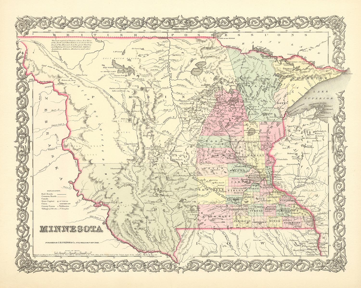
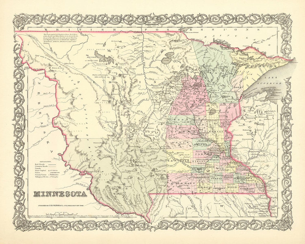


Old Map of Minnesota by J. H. Colton, 1856: St. Paul, St. Anthony, Stillwater, Mendota, and Wabasha
- All taxes and duties included
- Handmade & dispatched in 1-2 days
-
FREE gift preview
ⓘ
Digital gift preview
New for 2025: After you complete your order, you can send a beautiful digital preview to the gift recipient. Just provide their email address and we'll do the rest. (Their email address will not be stored or used for any other purpose.)
This is perfect for Christmas gifting, particularly if you're concerned that your order might not arrive in time for Christmas.
-
90 day money back guarantee
ⓘ
90 days to return and refund
Products can be returned within 90 days for a full refund, or exchange for another product.
For personalised and custom made items, we may offer you store credit or a non-expiring gift card, as we cannot resell personalised orders.
If you have any questions, get in touch. For more information, see our full returns & exchanges policy.

My maps are rare, museum-grade, restored old maps sourced from libraries, auction houses and private collections across the globe.
Framing & free personalisation available
1. Select your size
2. Frame & personalise your map
There is limited framing & personalisation capacity available. Order by 10am tomorrow for Christmas delivery.


Gift message & custom finish

If you want to add a gift message, or a finish (jigsaw, aluminium board, etc.) that is not available here, please request it in the "order note" when you check out.
Every order is custom made, so if you need the size adjusted slightly, or printed on an unusual material, just let us know. We've done thousands of custom orders over the years, so there's (almost) nothing we can't manage.
You can also contact us before you order, if you prefer!

- Handmade locally. No import duty or tax
- FREE Delivery by Christmas
- Love it or your money back (90 days)
- Questions? WhatsApp me any time
Own a piece of history
5,000+ 5 star reviews


Discover the allure of Minnesota's past with this exquisite map from 1856, crafted by the esteemed mapmaker J. H. Colton, whose reputation for precision and detail remains unparalleled. This artifact offers a unique glimpse into the early days of the United States, a time when the nation was still in its formative years and the concept of the American frontier was very much a reality.
This map of Minnesota is a testament to the rich tapestry of history that the region holds. During this period, many of the settlements that we know today were yet to be founded. The region was on the cusp of transformation, poised to embrace the westward expansion that would come to define the latter half of the 19th century. The map bears witness to a time when the land was still being charted, its borders yet to be firmly established.
The map showcases five notable settlements of the time: St. Paul, St. Anthony, Stillwater, Mendota, and Wabasha. These were the nuclei around which the state of Minnesota would grow and flourish. Each settlement carries its own story, its own unique contribution to the state's history. St. Paul, for instance, was in its infancy, just a few years away from being named the state capital. St. Anthony, on the other hand, was a thriving hub of the lumber industry, its falls powering sawmills that fed the burgeoning demand for timber.
This piece is not merely a map, but a snapshot of history. It captures a moment in time when the future was uncertain and the promise of what could be was as vast as the land itself. It reminds us of the explorers, pioneers, and settlers who dared to venture into the unknown, shaping the course of a nation in the process.
The mapmaker, J. H. Colton, is renowned for his meticulous attention to detail and his commitment to accuracy. His maps are more than just tools for navigation; they are works of art, each one a testament to his skill and dedication. This map of Minnesota is no exception. Every line, every marking, is a testament to Colton's commitment to his craft.
In the hands of the discerning collector, this map becomes more than a piece of history. It becomes a conversation starter, a statement piece, a testament to a time when the world was still being discovered. This map of Minnesota, crafted by the hands of J. H. Colton in 1856, is more than a map. It's a piece of America's past, a testament to the spirit of exploration and discovery that continues to shape our nation today.
Notable Settlements in Minnesota (Founded before 1856)
- St. Paul (1841): Known as Pig's Eye until 1841, it was renamed after the historic Chapel of Saint Paul and later became the state capital.
- St. Anthony (1849): This settlement, later incorporated into Minneapolis, was known for its flour mills powered by St. Anthony Falls.
- Stillwater (1848): Known as the birthplace of Minnesota, the territorial convention that led to Minnesota's statehood was held here.
- Mendota (1834): The oldest permanent settlement in Minnesota, it was an important fur trading post.
- Wabasha (1830): One of the oldest towns on the upper Mississippi River, it was named after a series of Mdewakanton Dakota chiefs.
- Marine on St. Croix (1839): Home to the first commercial sawmill on the St. Croix River.
- Fort Snelling (1819): A military fortification at the confluence of the Minnesota and Mississippi rivers.
- Belle Plaine (1854): Named "Beautiful Prairie" in French, it was a thriving agricultural center.
- Anoka (1844): Known as the "Halloween Capital of the World," it was a significant site for lumber production.
- Red Wing (1853): Named after a Mdewakanton Dakota chief, it was a major center for wheat trading.
- Mankato (1852): Named after the Dakota word for "blue earth," it was a key site for fur trading and agriculture.
- Winona (1851): Known for its lumber industry, it was named after a Dakota legend.
- Sauk Rapids (1851): Named after the rapids on the adjacent Mississippi River, it was a hub for fur trading.
- Hastings (1853): Named after the first governor of Minnesota Territory, it was a major river port.
- Shakopee (1851): Named after a Dakota chief, it was a significant site for fur trading.
- Faribault (1852): Named after its founder, it was a center for agriculture and milling.
- Owatonna (1854): Known for its mineral springs, it was named after a straight river in Dakota language.
- Northfield (1855): Known for its colleges and as the site of the Jesse James gang's attempted bank robbery.
- New Ulm (1854): Named after the German city of Ulm, it was a center for German immigration.
- Rochester (1854): Named after its founder's hometown in New York, it later became home to the world-renowned Mayo Clinic.
Indian Tribes and Territories
- Dakota Territory: The Dakota people, also known as the Sioux, were the primary Native American tribe in Minnesota.
- Ojibwe Territory: The Ojibwe, also known as the Chippewa, had significant presence in northern Minnesota.
Notable Natural Features
- Mississippi River: The iconic river runs through the state, shaping its geography and history.
- St. Anthony Falls: The only major waterfall on the Mississippi River, it powered the mills of St. Anthony.
- Lake Itasca: The source of the Mississippi River, it's now a popular state park.
- Boundary Waters Canoe Area Wilderness: A vast wilderness with over a thousand lakes and streams.
Historical Events (1810-1856)
- Treaty of Traverse des Sioux (1851): This treaty saw the Dakota people cede land in Minnesota to the U.S. government.
- Minnesota Organic Act (1849): This act established Minnesota as a territory.
- Treaty of Mendota (1851): This treaty also saw the Dakota people cede land to the U.S. government.
Please double check the images to make sure that a specific town or place is shown on this map. You can also get in touch and ask us to check the map for you.
This map looks great at all sizes: 12x16in (30.5x41cm), 16x20in (40.5x51cm), 18x24in (45.5x61cm), 24x30in (61x76cm), 32x40in (81.5x102cm), 40x50in (102x127cm), 48x60in (122x153cm) and 56x70in (142x178cm), but it looks even better when printed large.
I can create beautiful, large prints of this map up to 70in (178cm). Please get in touch if you're looking for larger, customised or different framing options.
The model in the listing images is holding the 16x20in (40.5x51cm) version of this map.
The fifth listing image shows an example of my map personalisation service.
If you’re looking for something slightly different, check out my main collection of USA and North America maps.
Please contact me to check if a certain location, landmark or feature is shown on this map.
This would make a wonderful birthday, Christmas, Father's Day, work leaving, anniversary or housewarming gift for someone from the areas covered by this map.
This map is available as a giclée print on acid free archival matte paper, or you can buy it framed. The frame is a nice, simple black frame that suits most aesthetics. Please get in touch if you'd like a different frame colour or material. My frames are glazed with super-clear museum-grade acrylic (perspex/acrylite), which is significantly less reflective than glass, safer, and will always arrive in perfect condition.
This map is also available as a float framed canvas, sometimes known as a shadow gap framed canvas or canvas floater. The map is printed on artist's cotton canvas and then stretched over a handmade box frame. We then "float" the canvas inside a wooden frame, which is available in a range of colours (black, dark brown, oak, antique gold and white). This is a wonderful way to present a map without glazing in front. See some examples of float framed canvas maps and explore the differences between my different finishes.
For something truly unique, this map is also available in "Unique 3D", our trademarked process that dramatically transforms the map so that it has a wonderful sense of depth. We combine the original map with detailed topography and elevation data, so that mountains and the terrain really "pop". For more info and examples of 3D maps, check my Unique 3D page.
For most orders, delivery time is about 3 working days. Personalised and customised products take longer, as I have to do the personalisation and send it to you for approval, which usually takes 1 or 2 days.
Please note that very large framed orders usually take longer to make and deliver.
If you need your order to arrive by a certain date, please contact me before you order so that we can find the best way of making sure you get your order in time.
I print and frame maps and artwork in 23 countries around the world. This means your order will be made locally, which cuts down on delivery time and ensures that it won't be damaged during delivery. You'll never pay customs or import duty, and we'll put less CO2 into the air.
All of my maps and art prints are well packaged and sent in a rugged tube if unframed, or surrounded by foam if framed.
I try to send out all orders within 1 or 2 days of receiving your order, though some products (like face masks, mugs and tote bags) can take longer to make.
If you select Express Delivery at checkout your order we will prioritise your order and send it out by 1-day courier (Fedex, DHL, UPS, Parcelforce).
Next Day delivery is also available in some countries (US, UK, Singapore, UAE) but please try to order early in the day so that we can get it sent out on time.
My standard frame is a gallery style black ash hardwood frame. It is simple and quite modern looking. My standard frame is around 20mm (0.8in) wide.
I use super-clear acrylic (perspex/acrylite) for the frame glass. It's lighter and safer than glass - and it looks better, as the reflectivity is lower.
Six standard frame colours are available for free (black, dark brown, dark grey, oak, white and antique gold). Custom framing and mounting/matting is available if you're looking for something else.
Most maps, art and illustrations are also available as a framed canvas. We use matte (not shiny) cotton canvas, stretch it over a sustainably sourced box wood frame, and then 'float' the piece within a wood frame. The end result is quite beautiful, and there's no glazing to get in the way.
All frames are provided "ready to hang", with either a string or brackets on the back. Very large frames will have heavy duty hanging plates and/or a mounting baton. If you have any questions, please get in touch.
See some examples of my framed maps and framed canvas maps.
Alternatively, I can also supply old maps and artwork on canvas, foam board, cotton rag and other materials.
If you want to frame your map or artwork yourself, please read my size guide first.
My maps are extremely high quality reproductions of original maps.
I source original, rare maps from libraries, auction houses and private collections around the world, restore them at my London workshop, and then use specialist giclée inks and printers to create beautiful maps that look even better than the original.
My maps are printed on acid-free archival matte (not glossy) paper that feels very high quality and almost like card. In technical terms the paper weight/thickness is 10mil/200gsm. It's perfect for framing.
I print with Epson ultrachrome giclée UV fade resistant pigment inks - some of the best inks you can find.
I can also make maps on canvas, cotton rag and other exotic materials.
Learn more about The Unique Maps Co.
Map personalisation
If you're looking for the perfect anniversary or housewarming gift, I can personalise your map to make it truly unique. For example, I can add a short message, or highlight an important location, or add your family's coat of arms.
The options are almost infinite. Please see my map personalisation page for some wonderful examples of what's possible.
To order a personalised map, select "personalise your map" before adding it to your basket.
Get in touch if you're looking for more complex customisations and personalisations.
Map ageing
I have been asked hundreds of times over the years by customers if they could buy a map that looks even older.
Well, now you can, by selecting Aged before you add a map to your basket.
All the product photos you see on this page show the map in its Original form. This is what the map looks like today.
If you select Aged, I will age your map by hand, using a special and unique process developed through years of studying old maps, talking to researchers to understand the chemistry of aging paper, and of course... lots of practice!
If you're unsure, stick to the Original colour of the map. If you want something a bit darker and older looking, go for Aged.
If you are not happy with your order for any reason, contact me and I'll get it fixed ASAP, free of charge. Please see my returns and refund policy for more information.
I am very confident you will like your restored map or art print. I have been doing this since 1984. I'm a 5-star Etsy seller. I have sold tens of thousands of maps and art prints and have over 5,000 real 5-star reviews. My work has been featured in interior design magazines, on the BBC, and on the walls of dozens of 5-star hotels.
I use a unique process to restore maps and artwork that is massively time consuming and labour intensive. Hunting down the original maps and illustrations can take months. I use state of the art and eye-wateringly expensive technology to scan and restore them. As a result, I guarantee my maps and art prints are a cut above the rest. I stand by my products and will always make sure you're 100% happy with what you receive.
Almost all of my maps and art prints look amazing at large sizes (200cm, 6.5ft+) and I can frame and deliver them to you as well, via special oversized courier. Contact me to discuss your specific needs.
Or try searching for something!


