


Ancient World Map by Al-Idrisi, 1154: Tabula Rogeriana, Arabia Center of the World
- All taxes and duties included
- Handmade & dispatched in 1-2 days
-
90 day money back guarantee
ⓘ
90 days to return and refund
Products can be returned within 90 days for a full refund, or exchange for another product.
For personalised and custom made items, we may offer you store credit or a non-expiring gift card, as we cannot resell personalised orders.
If you have any questions, get in touch. For more information, see our full returns & exchanges policy.

My maps are rare, museum-grade, restored old maps sourced from libraries, auction houses and private collections across the globe.
Framing & free personalisation available
1. Select your size
2. Frame & personalise your map
There is limited framing & personalisation capacity available. Order soon for Christmas delivery.


Gift message & custom finish

If you want to add a gift message, or a finish (jigsaw, aluminium board, etc.) that is not available here, please request it in the "order note" when you check out.
Every order is custom made, so if you need the size adjusted slightly, or printed on an unusual material, just let us know. We've done thousands of custom orders over the years, so there's (almost) nothing we can't manage.
You can also contact us before you order, if you prefer!

- Handmade locally. No import duty or tax
- FREE Delivery by Christmas
- Love it or your money back (90 days)
- Questions? WhatsApp me any time
Own a piece of history
5,000+ 5 star reviews


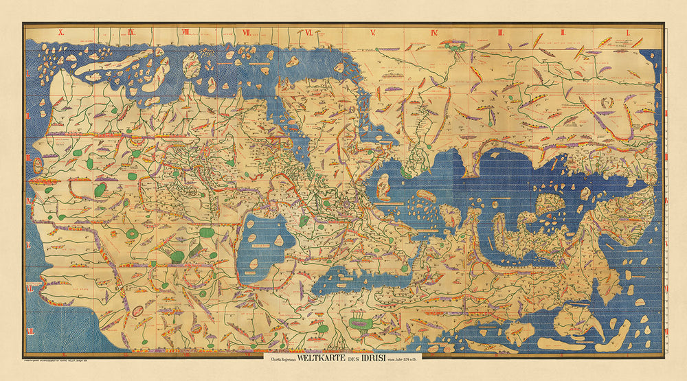
Embark on a journey through time with the illustrious Charta Rogeriana, a world map meticulously crafted by the renowned Arab geographer, Muhammad Al-Idrisi, in the year 1154. This masterpiece, also known as the Tabula Rogeriana, was commissioned by the Norman King Roger II of Sicily, encapsulating a world far beyond the reaches of the Mediterranean. Al-Idrisi's groundbreaking work, based on extensive interviews with seasoned travelers and the synthesis of reliable knowledge, represents a confluence of geography, climate, and exploration, artfully depicted across continents from Europe to Asia, and Africa to the Indian Ocean. This thematic map, with its unique south-at-the-top orientation, extends from the shores of Spain to the expanse of Korea, charting lands both known and mysterious to the medieval mind.
Muhammad Al-Idrisi, a figure of enlightenment at the cosmopolitan court of Sicily, embarked on this monumental task, not merely as a cartographer but as a chronicler of the world's diversity. Over fifteen years, Al-Idrisi melded the wisdom of travelers with his own scholarly insights to produce a work that transcended the boundaries of his time. The Charta Rogeriana is not just a map; it is a narrative of climates, regions, and the peoples who inhabit them, from the bustling cities of Europe to the remote frontiers of Asia and the varied landscapes of Africa. His innovative approach, dividing the world into seven climate zones, echoes the classical traditions while introducing a precision and detail that would remain unrivaled for centuries.
The design and cartographic projection of the Charta Rogeriana are a testament to Al-Idrisi's visionary mind. Orienting the map with south at the top, he challenged the conventional perceptions of space and direction, placing the Arabian Peninsula at the center of the world. This orientation was not just a geographical statement but a symbolic one, highlighting the importance of the Islamic world in the medieval era. The map's detailed depiction of mountains, rivers, towns, and roads, along with distances between key locations, offers a window into the medieval world's geography and its interconnectedness, revealing the routes that traders, travelers, and explorers traversed across continents.
The historical significance of the Charta Rogeriana cannot be overstated. For three centuries, it stood as the most accurate and comprehensive world map, a testament to the intellectual heritage of the Islamic Golden Age and its contributions to global knowledge. Al-Idrisi's work was not only a geographical record but also a cultural bridge, bringing together the diverse knowledge of the world's peoples in a time of flourishing trade and dialogue between civilizations. The map, with its intricate details and vast coverage, from the British Isles to the steppes of Russia and the coasts of Africa, embodies the spirit of exploration and curiosity that defined the era.
Today, the Charta Rogeriana is celebrated not just for its historical value but as a symbol of cross-cultural exchange and the unending quest for understanding our world. The map, as reimagined by Konrad Miller in the early 20th century, preserves the essence of Al-Idrisi's original creation, offering modern audiences a glimpse into the medieval world's complexity and richness. This map is more than a navigational tool; it is a bridge across time, inviting us to explore the interconnectedness of human history, the diversity of our landscapes, and the shared journey of discovery that continues to inspire generations.
Countries and regions on this map
- Africa
- Asia
- Europe
- Bilad al-Andalus
- Bilad al-Frank
- Bilad al-Hind
- Bilad al-Maghrib
- Bilad al-Sham
- Bilad al-Sudan
- Bilad al-Yaman
- China
- Egypt
- England
- Ethiopia
- France
- Germany
- Greece
- India
- Iraq
- Ireland
- Italy
- Japan
- Korea
- Libya
- Morocco
- Norway
- Palestine
- Persia
- Poland
- Portugal
- Russia
- Scandinavia
- Scotland
- Sicily
- Spain
- Sweden
- Syria
- Turkey
- Ukraine
- Wales
Historical and design context
- Title: Charta Rogeriana Weltkarte des Idrisi vom Jahr 1154 n.Ch.
- Date: 1154
- Mapmaker: Muhammad Al-Idrisi
- Publisher: Konrad Miller
- Topics: World map, Thematic map
- Themes: Geography, climate, travel, exploration
- Design: Oriented with south at the top, extending from Spain to Korea. A large continent stretches out from eastern Africa, landlocking the Indian Ocean except for the eastern side. Mountains, lakes, rivers and towns are represented, as well as roads and distances.
- Historical significance: The map is oriented with the North at the bottom. It remained the most accurate world map for the next three centuries.
Please double check the images to make sure that a specific town or place is shown on this map. You can also get in touch and ask us to check the map for you.
This map looks great at every size, but I always recommend going for a larger size if you have space. That way you can easily make out all of the details.
This map looks amazing at sizes all the way up to 100in (250cm). If you are looking for a larger map, please get in touch.
Please note: the labels on this map are hard to read if you order a map that is 40in (100cm) or smaller. The map is still very attractive, but if you would like to read the map easily, please buy a larger size.
This map is wider than most maps, which would make it a perfect statement piece above a mantelpiece, sofa or desk.
The fifth listing image shows an example of my map personalisation service.
If you’re looking for something slightly different, check out my collection of the best old maps to see if something else catches your eye.
Please contact me to check if a certain location, landmark or feature is shown on this map.
This would make a wonderful birthday, Christmas, Father's Day, work leaving, anniversary or housewarming gift for someone from the areas covered by this map.
This map is available as a giclée print on acid free archival matte paper, or you can buy it framed. The frame is a nice, simple black frame that suits most aesthetics. Please get in touch if you'd like a different frame colour or material. My frames are glazed with super-clear museum-grade acrylic (perspex/acrylite), which is significantly less reflective than glass, safer, and will always arrive in perfect condition.
This map is also available as a float framed canvas, sometimes known as a shadow gap framed canvas or canvas floater. The map is printed on artist's cotton canvas and then stretched over a handmade box frame. We then "float" the canvas inside a wooden frame, which is available in a range of colours (black, dark brown, oak, antique gold and white). This is a wonderful way to present a map without glazing in front. See some examples of float framed canvas maps and explore the differences between my different finishes.
For something truly unique, this map is also available in "Unique 3D", our trademarked process that dramatically transforms the map so that it has a wonderful sense of depth. We combine the original map with detailed topography and elevation data, so that mountains and the terrain really "pop". For more info and examples of 3D maps, check my Unique 3D page.
For most orders, delivery time is about 3 working days. Personalised and customised products take longer, as I have to do the personalisation and send it to you for approval, which usually takes 1 or 2 days.
Please note that very large framed orders usually take longer to make and deliver.
If you need your order to arrive by a certain date, please contact me before you order so that we can find the best way of making sure you get your order in time.
I print and frame maps and artwork in 23 countries around the world. This means your order will be made locally, which cuts down on delivery time and ensures that it won't be damaged during delivery. You'll never pay customs or import duty, and we'll put less CO2 into the air.
All of my maps and art prints are well packaged and sent in a rugged tube if unframed, or surrounded by foam if framed.
I try to send out all orders within 1 or 2 days of receiving your order, though some products (like face masks, mugs and tote bags) can take longer to make.
If you select Express Delivery at checkout your order we will prioritise your order and send it out by 1-day courier (Fedex, DHL, UPS, Parcelforce).
Next Day delivery is also available in some countries (US, UK, Singapore, UAE) but please try to order early in the day so that we can get it sent out on time.
My standard frame is a gallery style black ash hardwood frame. It is simple and quite modern looking. My standard frame is around 20mm (0.8in) wide.
I use super-clear acrylic (perspex/acrylite) for the frame glass. It's lighter and safer than glass - and it looks better, as the reflectivity is lower.
Six standard frame colours are available for free (black, dark brown, dark grey, oak, white and antique gold). Custom framing and mounting/matting is available if you're looking for something else.
Most maps, art and illustrations are also available as a framed canvas. We use matte (not shiny) cotton canvas, stretch it over a sustainably sourced box wood frame, and then 'float' the piece within a wood frame. The end result is quite beautiful, and there's no glazing to get in the way.
All frames are provided "ready to hang", with either a string or brackets on the back. Very large frames will have heavy duty hanging plates and/or a mounting baton. If you have any questions, please get in touch.
See some examples of my framed maps and framed canvas maps.
Alternatively, I can also supply old maps and artwork on canvas, foam board, cotton rag and other materials.
If you want to frame your map or artwork yourself, please read my size guide first.
My maps are extremely high quality reproductions of original maps.
I source original, rare maps from libraries, auction houses and private collections around the world, restore them at my London workshop, and then use specialist giclée inks and printers to create beautiful maps that look even better than the original.
My maps are printed on acid-free archival matte (not glossy) paper that feels very high quality and almost like card. In technical terms the paper weight/thickness is 10mil/200gsm. It's perfect for framing.
I print with Epson ultrachrome giclée UV fade resistant pigment inks - some of the best inks you can find.
I can also make maps on canvas, cotton rag and other exotic materials.
Learn more about The Unique Maps Co.
Map personalisation
If you're looking for the perfect anniversary or housewarming gift, I can personalise your map to make it truly unique. For example, I can add a short message, or highlight an important location, or add your family's coat of arms.
The options are almost infinite. Please see my map personalisation page for some wonderful examples of what's possible.
To order a personalised map, select "personalise your map" before adding it to your basket.
Get in touch if you're looking for more complex customisations and personalisations.
Map ageing
I have been asked hundreds of times over the years by customers if they could buy a map that looks even older.
Well, now you can, by selecting Aged before you add a map to your basket.
All the product photos you see on this page show the map in its Original form. This is what the map looks like today.
If you select Aged, I will age your map by hand, using a special and unique process developed through years of studying old maps, talking to researchers to understand the chemistry of aging paper, and of course... lots of practice!
If you're unsure, stick to the Original colour of the map. If you want something a bit darker and older looking, go for Aged.
If you are not happy with your order for any reason, contact me and I'll get it fixed ASAP, free of charge. Please see my returns and refund policy for more information.
I am very confident you will like your restored map or art print. I have been doing this since 1984. I'm a 5-star Etsy seller. I have sold tens of thousands of maps and art prints and have over 5,000 real 5-star reviews. My work has been featured in interior design magazines, on the BBC, and on the walls of dozens of 5-star hotels.
I use a unique process to restore maps and artwork that is massively time consuming and labour intensive. Hunting down the original maps and illustrations can take months. I use state of the art and eye-wateringly expensive technology to scan and restore them. As a result, I guarantee my maps and art prints are a cut above the rest. I stand by my products and will always make sure you're 100% happy with what you receive.
Almost all of my maps and art prints look amazing at large sizes (200cm, 6.5ft+) and I can frame and deliver them to you as well, via special oversized courier. Contact me to discuss your specific needs.
Or try searching for something!


