


Large Wall Map of London by Stanford, 1905: Red Coloured Victorian Chart
Buy 2, Get 1 More Free
If you add 2 items to your bag, you can add a third product for free. The discount is automatic - no code required.
This is equivalent to 33% off, which will be the largest discount available on my shop this year.
This works for all maps and artwork. You can order 3 of the same thing, or 3 different things.
Custom maps are excluded, as they're too time consuming to make and we'd prefer to take our time rather than rush through a lot of orders.
Contact me if you have any questions.
- All taxes and duties included
- Handmade & dispatched in 1-2 days
-
Complimentary gifting & design advice
ⓘ
Complimentary gifting & design advice
Available almost 24/7 on WhatsApp and email — we usually reply within minutes. We can help you:
- Choose a perfectly personalised gift
- Send a digital gift preview to the recipient
- Pick the ideal size for your wall
- Select the right finish and frame
Quick, friendly advice so you can order with confidence.
For last minute gifts, consider buying a digital gift card. We have over 5,000 maps and art prints to choose from.
-
90-day returns & 5-year guarantee
ⓘ
90-day returns & 5-year guarantee
Products can be returned within 90 days for a full refund, or exchange for another product.
We are also proud to offer a 5-year quality guarantee on our maps and art, covering defects in materials or workmanship under normal use.
For personalised and custom made items, we may offer you store credit or a non-expiring gift card, as we cannot resell personalised orders.
If you have any questions, get in touch. For more information, see our full returns & exchanges policy.

This is a museum-grade archival print from the original 1905 map — restored in our workshop and made to order on 220gsm archival matte paper or 400gsm artist's cotton canvas with pigment inks.
Professional framing & free personalisation available
1. Choose a size
2. Frame & personalise your map
Make your map unique with framing, hand-drawn customisation, vintage ageing, pop art text, unique 3D styling and more.


Gift message & custom finish

If you want to add a gift message, or a finish (jigsaw, aluminium board, etc.) that is not available here, please request it in the "order note" when you check out.
Every order is custom made, so if you need the size adjusted slightly, or printed on an unusual material, just let us know. We've done thousands of custom orders over the years, so there's (almost) nothing we can't manage.
You can also contact us before you order, if you prefer!

- Handmade locally. No import duty or tax
- FREE worldwide delivery
- 90-day returns & 5-year product guarantee
- Questions? WhatsApp me any time
Own a piece of history
7,000+ 5 star reviews


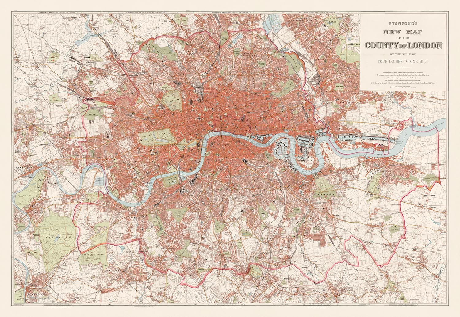
Dive into the intricate details of the Edwardian era with "Stanford's New Map of London," a masterpiece crafted in 1905 by the esteemed British cartographer Edward Stanford.
The colouring on this map is very similar to a map of London sold by the design company Timothy Oulton. We can create a smaller crop of this map (the same as Timothy Oulton's map) or you can buy the full size map of London that you see here.
Renowned for his precision and attention to detail, Stanford's work captures the sprawling expanse of London at a pivotal moment in its history. This map not only delineates the bustling streets and burgeoning neighborhoods but also serves as a historical document, offering a glimpse into the urban landscape of London during the early 20th century. From the regal Westminster to the vibrant streets of Camden and the tranquil expanses of Richmond upon Thames, this map is a portal to the past, showcasing the city in its Victorian grandeur.
Edward Stanford's dedication to accuracy is evident in the map's detailed portrayal of significant landmarks that define London's skyline and streetscape. Iconic structures such as Buckingham Palace, St. Paul's Cathedral, and the Houses of Parliament are meticulously plotted. Moreover, the map includes lesser-known yet historically significant sites like the Royal Opera House and the Barbican Centre, making it an invaluable resource for both historians and enthusiasts of architectural heritage. The inclusion of the burgeoning railway system and the nascent London Underground routes highlights the era's technological advancements and their role in shaping modern London.
The map's extensive coverage of London's waterways and green spaces adds another layer of depth to its historical and aesthetic appeal. The winding path of the River Thames is prominently featured, flanked by newly developed areas along its banks. Large parks such as Hyde Park and the Regent's Park are carefully detailed, reflecting their importance as public spaces in urban planning and their role as green lungs amidst the city's dense construction. These elements make the map not only a navigational tool but also a reflection of London's environmental consciousness at the turn of the century.
Stanford's map also serves as a comprehensive guide to London's extensive network of streets, from the bustling Oxford Street to the historic Fleet Street. The inclusion of such thoroughfares offers a fascinating insight into the city's commercial and social hubs, which have evolved over the decades but still retain their fundamental routes as depicted in this 1905 snapshot. For anyone keen on urban development, this map provides a foundational understanding of how London's famous roads and locales have transformed and what has remained constant through times of change.
Lastly, "Stanford's New Map of London" is more than just a cartographic creation; it is a piece of art and a collector's item for those who cherish maps as gateways to the worlds they represent. The traditional Victorian style, with its focus on both aesthetic appeal and functional accuracy, makes this map a distinguished piece among Stanford's prolific works. For collectors, historians, and admirers of London, this map is not merely a depiction of geography; it is a rich, woven tapestry of history, architecture, and culture, captured at a moment when London was rapidly stepping into the modern age.
Streets and roads on this map
- Abbey Road
- Adelaide Road
- Aldersgate Street
- Aldgate
- Baker Street
- Bayswater Road
- Bishopsgate Street
- Blackfriars Road
- Bow Road
- Brixton Road
- Broad Street
- Brompton Road
- Buckingham Palace Road
- Cambridge Road
- Camden Road
- Cannon Street
- Chancery Lane
- Cheapside
- Charing Cross Road
- City Road
- Commercial Road
- Cornhill
- Coventry Street
- Cranbourn Street
- Edgware Road
- Euston Road
- Farringdon Street
- Fleet Street
- Great Eastern Street
- Great Portland Street
- Great Queen Street
- Great Russell Street
- Great Smith Street
- Great Western Road
- Grosvenor Place
- Guilford Street
- Hammersmith Road
- Hampstead Road
- Hanover Square
- Haymarket
- High Holborn
- Holborn
- Holloway Road
- Hyde Park Street
- Kensington Gore
- Kensington Road
- Kent Road
- King Street
- Kingsland Road
- Knightsbridge
- Leadenhall Street
- Leicester Square
- Lincoln's Inn Fields
- Liverpool Street
- Lombard Street
- Long Acre
- Ludgate Hill
- Marylebone Lane
- Mile End Road
- Moorgate Street
- New Bond Street
- New Oxford Street
- Old Bailey
- Old Bond Street
- Oxford Street
- Park Lane
- Piccadilly
- Portland Place
- Praed Street
- Prince of Wales Road
- Queen Victoria Street
- Regent Street
- St. Giles High Street
- St. James's Street
- St. John Street
- St. Martin's Lane
- St. Paul's Churchyard
- Strand
- Theobald's Road
- Tottenham Court Road
- Trafalgar Square
- Upper Street
- Walworth Road
- Warwick Square
- Waterloo Road
- Watling Street
- Wellington Street
- Whitechapel Road
- Wigmore Street
- Wood Street
Notable Features & Landmarks
- The Tower of London
- St. Paul's Cathedral
- Buckingham Palace
- The Houses of Parliament
- The British Museum
- The Natural History Museum
- The Science Museum
- The Victoria and Albert Museum
- The Tate Gallery
- The National Gallery
- The Royal Albert Hall
- The Royal Opera House
- The Leadenhall Building
- The Lloyd's Building
- The St. Mary Axe
- The Serpentine
- The Round Pond
- The Regent's Canal
- The Grand Union Canal
- The River Thames
- Hyde Park
- Kensington Gardens
- Green Park
- St. James's Park
- The Regent's Park
- Primrose Hill
- Hampstead Heath
- Epping Forest
- Hainault Forest
- Wimbledon Common
- Richmond Park
- Bushy Park
- Hampton Court Park
- The London Underground
- The M25 motorway
- The A406 North Circular Road
- The A232 South Circular Road
Historical and design context
- Map name: Stanford's New Map of London
- Creation date: 1905
- Mapmaker/publisher: Edward Stanford
- Covers a wide area including Central London
- Traditional Victorian style with a focus on detail and accuracy
- High key background and red coloured buildings to match Timothy Oulton's similar map of London
- Valuable historical document providing a snapshot of London at the turn of the 20th century
Please double check the images to make sure that a specific town or place is shown on this map. You can also get in touch and ask us to check the map for you.
This is a very large map that must be ordered at a large size, so that you can easily make out all of the details.
This map looks amazing at sizes all the way up to a few metres. If you are looking for a larger map, please get in touch.
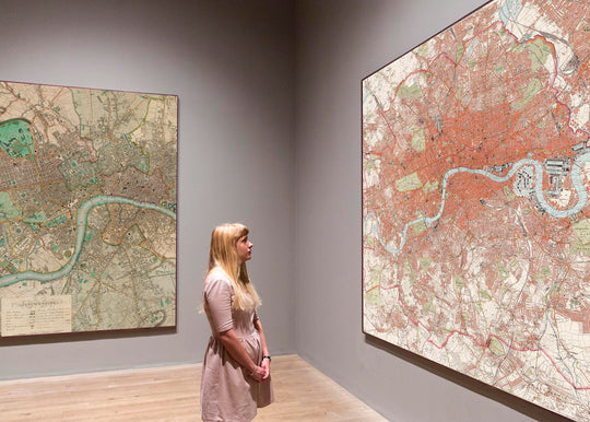
The model in the listing images is holding the 24x36in (60x90cm) version of this map.
The fifth listing image shows an example of my map personalisation service.
If you’re looking for something slightly different, check out my collection of the best old maps to see if something else catches your eye.
Please contact me to check if a certain location, landmark or feature is shown on this map.
This would make a wonderful birthday, Christmas, Father's Day, work leaving, anniversary or housewarming gift for someone from the areas covered by this map.
This map is available as a giclée print on acid free archival matte paper, or you can buy it framed. The frame is a nice, simple black frame that suits most aesthetics. Please get in touch if you'd like a different frame colour or material. My frames are glazed with super-clear museum-grade acrylic (perspex/acrylite), which is significantly less reflective than glass, safer, and will always arrive in perfect condition.
This map is also available as a float framed canvas, sometimes known as a shadow gap framed canvas or canvas floater. The map is printed on artist's cotton canvas and then stretched over a handmade box frame. We then "float" the canvas inside a wooden frame, which is available in a range of colours (black, dark brown, oak, antique gold and white). This is a wonderful way to present a map without glazing in front. See some examples of float framed canvas maps and explore the differences between my different finishes.
For something truly unique, this map is also available in "Unique 3D", our trademarked process that dramatically transforms the map so that it has a wonderful sense of depth. We combine the original map with detailed topography and elevation data, so that mountains and the terrain really "pop". For more info and examples of 3D maps, check my Unique 3D page.
For most orders, delivery time is about 3 working days. Personalised and customised products take longer, as I have to do the personalisation and send it to you for approval, which usually takes 1 or 2 days.
Please note that very large framed orders usually take longer to make and deliver.
If you need your order to arrive by a certain date, please contact me before you order so that we can find the best way of making sure you get your order in time.
I print and frame maps and artwork in 23 countries around the world. This means your order will be made locally, which cuts down on delivery time and ensures that it won't be damaged during delivery. You'll never pay customs or import duty, and we'll put less CO2 into the air.
All of my maps and art prints are well packaged and sent in a rugged tube if unframed, or surrounded by foam if framed.
I try to send out all orders within 1 or 2 days of receiving your order, though some products (like face masks, mugs and tote bags) can take longer to make.
If you select Express Delivery at checkout your order we will prioritise your order and send it out by 1-day courier (Fedex, DHL, UPS, Parcelforce).
Next Day delivery is also available in some countries (US, UK, Singapore, UAE) but please try to order early in the day so that we can get it sent out on time.
My standard frame is a gallery style black ash hardwood frame. It is simple and quite modern looking. My standard frame is around 20mm (0.8in) wide.
I use super-clear acrylic (perspex/acrylite) for the frame glass. It's lighter and safer than glass - and it looks better, as the reflectivity is lower.
Six standard frame colours are available for free (black, dark brown, dark grey, oak, white and antique gold). Custom framing and mounting/matting is available if you're looking for something else.
Most maps, art and illustrations are also available as a framed canvas. We use matte (not shiny) cotton canvas, stretch it over a sustainably sourced box wood frame, and then 'float' the piece within a wood frame. The end result is quite beautiful, and there's no glazing to get in the way.
All frames are provided "ready to hang", with either a string or brackets on the back. Very large frames will have heavy duty hanging plates and/or a mounting baton. If you have any questions, please get in touch.
See some examples of my framed maps and framed canvas maps.
Alternatively, I can also supply old maps and artwork on canvas, foam board, cotton rag and other materials.
If you want to frame your map or artwork yourself, please read my size guide first.
My maps are extremely high quality reproductions of original maps.
I source original, rare maps from libraries, auction houses and private collections around the world, restore them at my London workshop, and then use specialist giclée inks and printers to create beautiful maps that look even better than the original.
My maps are printed on acid-free archival matte (not glossy) paper that feels very high quality and almost like card. In technical terms the paper weight/thickness is 10mil/200gsm. It's perfect for framing.
I print with Epson ultrachrome giclée UV fade resistant pigment inks - some of the best inks you can find.
I can also make maps on canvas, cotton rag and other exotic materials.
Learn more about The Unique Maps Co.
Map personalisation
If you're looking for the perfect anniversary or housewarming gift, I can personalise your map to make it truly unique. For example, I can add a short message, or highlight an important location, or add your family's coat of arms.
The options are almost infinite. Please see my map personalisation page for some wonderful examples of what's possible.
To order a personalised map, select "personalise your map" before adding it to your basket.
Get in touch if you're looking for more complex customisations and personalisations.
Map ageing
I have been asked hundreds of times over the years by customers if they could buy a map that looks even older.
Well, now you can, by selecting Aged before you add a map to your basket.
All the product photos you see on this page show the map in its Original form. This is what the map looks like today.
If you select Aged, I will age your map by hand, using a special and unique process developed through years of studying old maps, talking to researchers to understand the chemistry of aging paper, and of course... lots of practice!
If you're unsure, stick to the Original colour of the map. If you want something a bit darker and older looking, go for Aged.
If you are not happy with your order for any reason, contact me and I'll get it fixed ASAP, free of charge. Please see my returns and refund policy for more information.
I am very confident you will like your restored map or art print. I have been doing this since 1984. I'm a 5-star Etsy seller. I have sold tens of thousands of maps and art prints and have over 5,000 real 5-star reviews. My work has been featured in interior design magazines, on the BBC, and on the walls of dozens of 5-star hotels.
I use a unique process to restore maps and artwork that is massively time consuming and labour intensive. Hunting down the original maps and illustrations can take months. I use state of the art and eye-wateringly expensive technology to scan and restore them. As a result, I guarantee my maps and art prints are a cut above the rest. I stand by my products and will always make sure you're 100% happy with what you receive.
Almost all of my maps and art prints look amazing at large sizes (200cm, 6.5ft+) and I can frame and deliver them to you as well, via special oversized courier. Contact me to discuss your specific needs.
Or try searching for something!


