


Old Map of Arkansas by J.H. Colton, 1855: Little Rock, Fort Smith, Fayetteville, Pine Bluff, Van Buren
- All taxes and duties included
- Handmade & dispatched in 1-2 days
-
FREE gift preview
ⓘ
Digital gift preview
New for 2025: After you complete your order, you can send a beautiful digital preview to the gift recipient. Just provide their email address and we'll do the rest. (Their email address will not be stored or used for any other purpose.)
This is perfect for Christmas gifting, particularly if you're concerned that your order might not arrive in time for Christmas.
-
90 day money back guarantee
ⓘ
90 days to return and refund
Products can be returned within 90 days for a full refund, or exchange for another product.
For personalised and custom made items, we may offer you store credit or a non-expiring gift card, as we cannot resell personalised orders.
If you have any questions, get in touch. For more information, see our full returns & exchanges policy.

My maps are rare, museum-grade, restored old maps sourced from libraries, auction houses and private collections across the globe.
Framing & free personalisation available
1. Select your size
2. Frame & personalise your map
There is limited framing & personalisation capacity available. Order by 10am tomorrow for Christmas delivery.


Gift message & custom finish

If you want to add a gift message, or a finish (jigsaw, aluminium board, etc.) that is not available here, please request it in the "order note" when you check out.
Every order is custom made, so if you need the size adjusted slightly, or printed on an unusual material, just let us know. We've done thousands of custom orders over the years, so there's (almost) nothing we can't manage.
You can also contact us before you order, if you prefer!

- Handmade locally. No import duty or tax
- FREE Delivery by Christmas
- Love it or your money back (90 days)
- Questions? WhatsApp me any time
Own a piece of history
5,000+ 5 star reviews


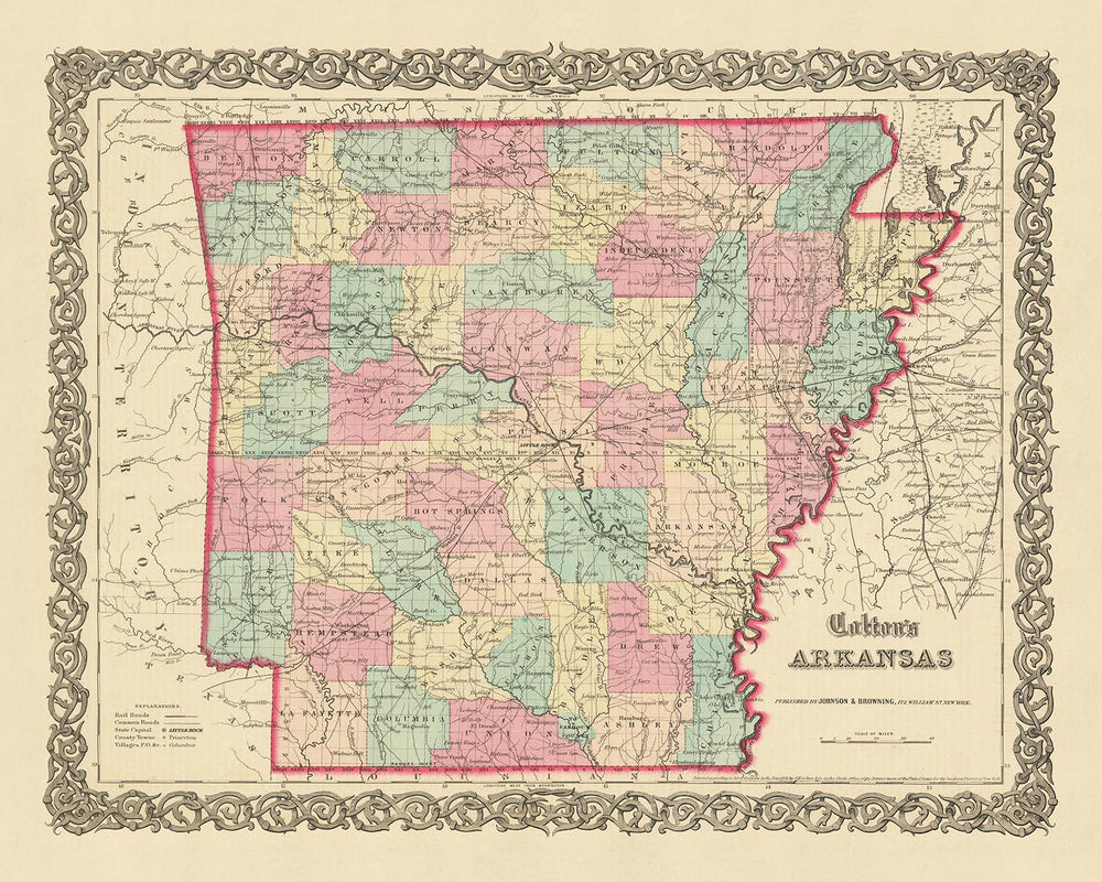
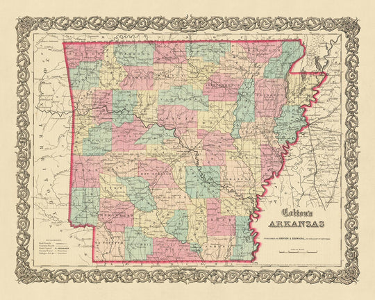
Immerse yourself in the rich history of the United States with this stunning old map of Arkansas, meticulously crafted by J.H. Colton in 1855. This period piece hails from a time when the United States was still in its infancy, a mere 79 years after the signing of the Declaration of Independence. It offers a unique glimpse into the early stages of American development, capturing the essence of an era when many of the settlements we know today were yet to be founded.
This map is a testament to the unrivaled skill and precision of J.H. Colton, widely regarded as the finest American mapmaker of his time. His maps are renowned for their accuracy and attention to detail, and this piece is no exception. It showcases the region of Arkansas as it was in 1855, complete with the borders and place names of the time. As you explore this map, you will find that many of these names and borders have changed over the past 150 years, reflecting the dynamic nature of American history.
The map features the five most notable settlements in Arkansas during 1855: Little Rock, Fort Smith, Fayetteville, Pine Bluff, and Van Buren. Each of these settlements holds a unique place in the history of Arkansas, and their depiction on this map serves as a testament to their historical significance. Little Rock, the state capital, is prominently displayed, as are the bustling towns of Fort Smith and Fayetteville. Pine Bluff and Van Buren, though smaller in size, are equally significant in the history of the state.
As you delve deeper into this map, you'll discover a wealth of historical details waiting to be uncovered. Whether you're a history enthusiast, a map collector, or simply someone who appreciates fine craftsmanship, this old map of Arkansas by J.H. Colton is a must-have addition to your collection.
Towns and Settlements in Arkansas (1855)
- Little Rock (1821): Known as the state capital and most populous city of Arkansas, it was originally named "La Petite Roche" by French explorers.
- Fort Smith (1817): Established as a western frontier military post, it later became a vital center for law and order in the Wild West.
- Fayetteville (1828): Named after General Lafayette, a French hero of the American Revolutionary War, it's home to the University of Arkansas.
- Pine Bluff (1832): A key player in the state's timber industry, it was originally named "Pine Bluff Town" due to its location on a bluff overlooking the Arkansas River.
- Van Buren (1831): Named after President Martin Van Buren, it was an important port on the Arkansas River during the steamboat era.
- Bentonville (1837): Known as the birthplace of the retail giant Walmart.
- Hot Springs (1807): Famous for its naturally heated springs, it was a popular destination for rest and recuperation.
- Arkadelphia (1839): Known for its educational institutions, including Ouachita Baptist University and Henderson State University.
- Batesville (1810): One of the oldest towns in the state, it was a significant transportation hub during the steamboat era.
- Camden (1836): A significant port city on the Ouachita River, it was originally named "Ecore a Fabri" by French traders.
- Clarksville (1836): Named after William Clark of the Lewis and Clark Expedition, it's home to the University of the Ozarks.
- Conway (1851): Known for its higher education institutions, including the University of Central Arkansas.
- El Dorado (1843): A boomtown during the 1920s oil rush, it was originally named "Three Creeks".
- Eureka Springs (1852): Known for its Victorian architecture and natural springs, it's a popular tourist destination.
- Helena (1833): A key site during the Civil War, it was the starting point of the Expedition of the Thousand.
- Hope (1852): Birthplace of former President Bill Clinton.
- Jonesboro (1859): An agricultural hub, it's home to Arkansas State University.
- Magnolia (1853): Known for its annual Magnolia Blossom Festival and World Championship Steak Cookoff.
- Monticello (1849): Home to the University of Arkansas at Monticello.
- Russellville (1835): Known for its nuclear power plant, the only one in Arkansas.
Native American Tribes in Arkansas (1855)
- Caddo Tribe: Occupied the southwestern regions of Arkansas.
- Osage Tribe: Controlled the northern part of the state.
- Quapaw Tribe: Inhabited the eastern regions along the Mississippi River.
Notable Natural Features in Arkansas (1855)
- Arkansas River: The largest river in the state, a key transportation route.
- Ouachita Mountains: Known for their unique east-west orientation.
- Hot Springs National Park: Known for its thermal springs, a popular health resort.
- Buffalo National River: The first national river in the United States.
- Mammoth Spring: One of the largest springs in the United States.
Historical Events in Arkansas (1810-1855)
- Arkansas Territory Established (1819): The territory was officially organized on March 2, 1819.
- Statehood (1836): Arkansas was admitted to the Union as the 25th state on June 15, 1836.
- Mexican War (1846-1848): Arkansas troops played a key role in the war with Mexico.
- First State Fair (1851): The first state fair was held in Helena in October 1851.
Please double check the images to make sure that a specific town or place is shown on this map. You can also get in touch and ask us to check the map for you.
This map looks great at all sizes: 12x16in (30.5x41cm), 16x20in (40.5x51cm), 18x24in (45.5x61cm), 24x30in (61x76cm), 32x40in (81.5x102cm), 40x50in (102x127cm), 48x60in (122x153cm) and 56x70in (142x178cm), but it looks even better when printed large.
I can create beautiful, large prints of this map up to 70in (178cm). Please get in touch if you're looking for larger, customised or different framing options.
The model in the listing images is holding the 16x20in (40.5x51cm) version of this map.
The fifth listing image shows an example of my map personalisation service.
If you’re looking for something slightly different, check out my main collection of USA and North America maps.
Please contact me to check if a certain location, landmark or feature is shown on this map.
This would make a wonderful birthday, Christmas, Father's Day, work leaving, anniversary or housewarming gift for someone from the areas covered by this map.
This map is available as a giclée print on acid free archival matte paper, or you can buy it framed. The frame is a nice, simple black frame that suits most aesthetics. Please get in touch if you'd like a different frame colour or material. My frames are glazed with super-clear museum-grade acrylic (perspex/acrylite), which is significantly less reflective than glass, safer, and will always arrive in perfect condition.
This map is also available as a float framed canvas, sometimes known as a shadow gap framed canvas or canvas floater. The map is printed on artist's cotton canvas and then stretched over a handmade box frame. We then "float" the canvas inside a wooden frame, which is available in a range of colours (black, dark brown, oak, antique gold and white). This is a wonderful way to present a map without glazing in front. See some examples of float framed canvas maps and explore the differences between my different finishes.
For something truly unique, this map is also available in "Unique 3D", our trademarked process that dramatically transforms the map so that it has a wonderful sense of depth. We combine the original map with detailed topography and elevation data, so that mountains and the terrain really "pop". For more info and examples of 3D maps, check my Unique 3D page.
For most orders, delivery time is about 3 working days. Personalised and customised products take longer, as I have to do the personalisation and send it to you for approval, which usually takes 1 or 2 days.
Please note that very large framed orders usually take longer to make and deliver.
If you need your order to arrive by a certain date, please contact me before you order so that we can find the best way of making sure you get your order in time.
I print and frame maps and artwork in 23 countries around the world. This means your order will be made locally, which cuts down on delivery time and ensures that it won't be damaged during delivery. You'll never pay customs or import duty, and we'll put less CO2 into the air.
All of my maps and art prints are well packaged and sent in a rugged tube if unframed, or surrounded by foam if framed.
I try to send out all orders within 1 or 2 days of receiving your order, though some products (like face masks, mugs and tote bags) can take longer to make.
If you select Express Delivery at checkout your order we will prioritise your order and send it out by 1-day courier (Fedex, DHL, UPS, Parcelforce).
Next Day delivery is also available in some countries (US, UK, Singapore, UAE) but please try to order early in the day so that we can get it sent out on time.
My standard frame is a gallery style black ash hardwood frame. It is simple and quite modern looking. My standard frame is around 20mm (0.8in) wide.
I use super-clear acrylic (perspex/acrylite) for the frame glass. It's lighter and safer than glass - and it looks better, as the reflectivity is lower.
Six standard frame colours are available for free (black, dark brown, dark grey, oak, white and antique gold). Custom framing and mounting/matting is available if you're looking for something else.
Most maps, art and illustrations are also available as a framed canvas. We use matte (not shiny) cotton canvas, stretch it over a sustainably sourced box wood frame, and then 'float' the piece within a wood frame. The end result is quite beautiful, and there's no glazing to get in the way.
All frames are provided "ready to hang", with either a string or brackets on the back. Very large frames will have heavy duty hanging plates and/or a mounting baton. If you have any questions, please get in touch.
See some examples of my framed maps and framed canvas maps.
Alternatively, I can also supply old maps and artwork on canvas, foam board, cotton rag and other materials.
If you want to frame your map or artwork yourself, please read my size guide first.
My maps are extremely high quality reproductions of original maps.
I source original, rare maps from libraries, auction houses and private collections around the world, restore them at my London workshop, and then use specialist giclée inks and printers to create beautiful maps that look even better than the original.
My maps are printed on acid-free archival matte (not glossy) paper that feels very high quality and almost like card. In technical terms the paper weight/thickness is 10mil/200gsm. It's perfect for framing.
I print with Epson ultrachrome giclée UV fade resistant pigment inks - some of the best inks you can find.
I can also make maps on canvas, cotton rag and other exotic materials.
Learn more about The Unique Maps Co.
Map personalisation
If you're looking for the perfect anniversary or housewarming gift, I can personalise your map to make it truly unique. For example, I can add a short message, or highlight an important location, or add your family's coat of arms.
The options are almost infinite. Please see my map personalisation page for some wonderful examples of what's possible.
To order a personalised map, select "personalise your map" before adding it to your basket.
Get in touch if you're looking for more complex customisations and personalisations.
Map ageing
I have been asked hundreds of times over the years by customers if they could buy a map that looks even older.
Well, now you can, by selecting Aged before you add a map to your basket.
All the product photos you see on this page show the map in its Original form. This is what the map looks like today.
If you select Aged, I will age your map by hand, using a special and unique process developed through years of studying old maps, talking to researchers to understand the chemistry of aging paper, and of course... lots of practice!
If you're unsure, stick to the Original colour of the map. If you want something a bit darker and older looking, go for Aged.
If you are not happy with your order for any reason, contact me and I'll get it fixed ASAP, free of charge. Please see my returns and refund policy for more information.
I am very confident you will like your restored map or art print. I have been doing this since 1984. I'm a 5-star Etsy seller. I have sold tens of thousands of maps and art prints and have over 5,000 real 5-star reviews. My work has been featured in interior design magazines, on the BBC, and on the walls of dozens of 5-star hotels.
I use a unique process to restore maps and artwork that is massively time consuming and labour intensive. Hunting down the original maps and illustrations can take months. I use state of the art and eye-wateringly expensive technology to scan and restore them. As a result, I guarantee my maps and art prints are a cut above the rest. I stand by my products and will always make sure you're 100% happy with what you receive.
Almost all of my maps and art prints look amazing at large sizes (200cm, 6.5ft+) and I can frame and deliver them to you as well, via special oversized courier. Contact me to discuss your specific needs.
Or try searching for something!


