


Old Map of Duchy of Guelders and Zutphen by Visscher, 1690: Amsterdam, Amersfoort, Utrecht, Eindhoven, Nijmegen
- All taxes and duties included
- Handmade & dispatched in 1-2 days
-
FREE gift preview
ⓘ
Digital gift preview
New for 2025: After you complete your order, you can send a beautiful digital preview to the gift recipient. Just provide their email address and we'll do the rest. (Their email address will not be stored or used for any other purpose.)
This is perfect for Christmas gifting, particularly if you're concerned that your order might not arrive in time for Christmas.
-
90 day money back guarantee
ⓘ
90 days to return and refund
Products can be returned within 90 days for a full refund, or exchange for another product.
For personalised and custom made items, we may offer you store credit or a non-expiring gift card, as we cannot resell personalised orders.
If you have any questions, get in touch. For more information, see our full returns & exchanges policy.

My maps are rare, museum-grade, restored old maps sourced from libraries, auction houses and private collections across the globe.
Framing & free personalisation available
1. Select your size
2. Frame & personalise your map
There is limited framing & personalisation capacity available. Order by 10am tomorrow for Christmas delivery.


Gift message & custom finish

If you want to add a gift message, or a finish (jigsaw, aluminium board, etc.) that is not available here, please request it in the "order note" when you check out.
Every order is custom made, so if you need the size adjusted slightly, or printed on an unusual material, just let us know. We've done thousands of custom orders over the years, so there's (almost) nothing we can't manage.
You can also contact us before you order, if you prefer!

- Handmade locally. No import duty or tax
- FREE Delivery by Christmas
- Love it or your money back (90 days)
- Questions? WhatsApp me any time
Own a piece of history
5,000+ 5 star reviews


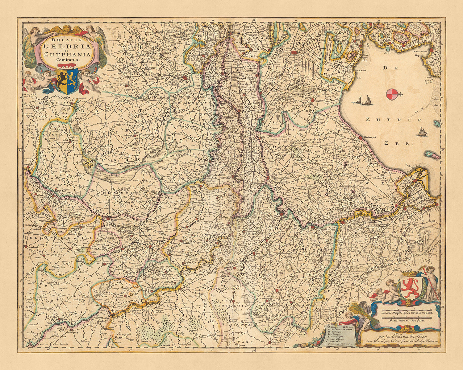
This exquisitely detailed map, 'Ducatus Geldria et Zutphania comitatus', is a historical treasure from the late 17th century. Crafted by the renowned cartographer Nicolaes Visscher II in 1690, it focuses on the Duchy of Guelders and Zutphen, areas now part of the modern Netherlands. The full name translates to 'Duchy of Guelders and County of Zutphen', providing a glimpse into the political divisions of the time.
The map prominently features five key cities: Amsterdam, Amersfoort, Utrecht, Eindhoven, and Nijmegen. Each city is represented with remarkable precision, reflecting the meticulous craftsmanship that is characteristic of Visscher's work. The map provides an intriguing snapshot of these cities and their surroundings during a time of significant historical change and development.
Amsterdam, the capital city of the Netherlands, is a significant highlight of this map. Its intricate network of canals and the bustling port area are beautifully depicted, hinting at the city's status as a major hub of trade and commerce during the Dutch Golden Age. Similarly, the cities of Utrecht and Amersfoort, with their strategic locations and fortifications, are portrayed in fascinating detail, reflecting their importance in regional politics and defense.
Eindhoven and Nijmegen, two other cities featured on the map, offer further insight into the region's history. Eindhoven, now known as a global hub for technology and design, is depicted as a small fortified town, while Nijmegen, one of the oldest cities in the Netherlands, is represented with its iconic city walls and surrounding rural landscape. This map, with its focus on the Duchy of Guelders and Zutphen, offers a captivating historical journey through these regions, making it a must-have for any collector or history enthusiast.
Some of the significant locations shown on this map:
Duchy of Guelders
- Amsterdam: Known as the "Venice of the North" for its extensive canals, it was a major hub of commerce during the Dutch Golden Age.
- Utrecht: An important religious center in the Netherlands, with the Dom Tower as its most notable landmark.
- Amersfoort: Known for its medieval architecture and fortifications, it was an important defensive city.
- Eindhoven: A small fortified town at the time, it's now a global hub for technology and design.
- Nijmegen: One of the oldest cities in the Netherlands, known for its city walls and surrounding rural landscape.
- Arnhem: Known for its strategic location near the Rhine River, it was a significant center of trade.
- Zutphen: An important center of printing during the Renaissance, it was known for its large library.
- Venlo: A fortified city on the Meuse River, it was an important center of trade and defense.
- Roermond: Known for its strategic location at the confluence of the Roer and Meuse rivers.
- Wageningen: An important agricultural center, known for its fertile soil and farming.
- Apeldoorn: Known for its beautiful parks and gardens, it was a popular retreat for the Dutch nobility.
- Deventer: One of the oldest cities in the Netherlands, it was an important center of trade and manufacturing.
- Harderwijk: Known for its university and as a member of the Hanseatic League, a commercial and defensive confederation of merchant guilds.
- Doesburg: Known for its well-preserved medieval city center and fortifications.
- Culemborg: Known for its strategic location on the Lek River, it was an important center of trade.
County of Zutphen
- Lochem: Known for its fortified city center and the surrounding rural landscape.
- Borculo: Known for its castle, it was a significant center of power in the region.
- Groenlo: Known for its fortifications, it was an important defensive city.
- Lichtenvoorde: Known for its castle and as a significant center of power in the region.
- Bredevoort: Known for its castle and as a significant center of power in the region.
- Vorden: Known for its castle and as a significant center of power in the region.
- Ruurlo: Known for its castle and as a significant center of power in the region.
- Warnsveld: Known for its church, it was an important religious center in the region.
- Zelhem: Known for its church, it was an important religious center in the region.
- Doetinchem: Known for its castle and as a significant center of power in the region.
- Terborg: Known for its castle and as a significant center of power in the region.
- Gendringen: Known for its castle and as a significant center of power in the region.
- 's-Heerenberg: Known for its castle and as a significant center of power in the region.
- Didam: Known for its church, it was an important religious center in the region.
- Zevenaar: Known for its fortified city center, it was an important defensive city.
Notable boundaries and natural phenomena:
- Rhine River: A major waterway for trade and transportation.
- Meuse River: Another significant waterway, known for its strategic importance.
- Veluwe: A large forest-rich ridge of hills, it's now a national park and a popular tourist destination.
- Betuwe: Known for its fertile soil and fruit production, it's a picturesque region with numerous orchards.
- Achterhoek: Known for its scenic landscape and castles, it's a popular tourist destination.
Notable historical events:
- The Eighty Years' War (1568-1648): A revolt of the Seventeen Provinces against the political and religious hegemony of Philip II of Spain.
- The Treaty of Nijmegen (1678): A series of peace treaties signed in the Dutch city of Nijmegen between August 1678 and 1679, which ended various interconnected wars among France, the Dutch Republic, Spain, Brandenburg, Sweden, Denmark, the Prince-Bishopric of Münster, and the Holy Roman Empire.
- The Franco-Dutch War (1672–1678): Often called the Dutch War, was a conflict that pitted the French kingdom, the Swedish empire, the Prince-Bishopric of Münster, the Archbishopric of Cologne and the Kingdom of England against the Dutch Republic, which was later joined by the Austrian Habsburg lands, Brandenburg-Prussia and Spain to form a Quadruple Alliance.
Please double check the images to make sure that a specific town or place is shown on this map. You can also get in touch and ask us to check the map for you.
This map looks great at all sizes: 12x16in (30.5x41cm), 16x20in (40.5x51cm), 18x24in (45.5x61cm), 24x30in (61x76cm), 32x40in (81.5x102cm), 40x50in (102x127cm), 48x60in (122x153cm) and 56x70in (142x178cm), but it looks even better when printed large.
I can create beautiful, large prints of this map up to 90in (229cm). Please get in touch if you're looking for larger, customised or different framing options.
The model in the listing images is holding the 16x20in (40.5x51cm) version of this map.
The fifth listing image shows an example of my map personalisation service.
The labels on this map are very small at 12x16in (30.5x41cm). The map is still very attractive, but you may struggle to read the smallest letters. Please buy a larger map if it's important to be able to read the map easily.
If you’re looking for something slightly different, check out my collection of the best old maps of Europe and European cities to see if something else catches your eye.
Please contact me to check if a certain location, landmark or feature is shown on this map.
This would make a wonderful birthday, Christmas, Father's Day, work leaving, anniversary or housewarming gift for someone from the areas covered by this map.
This map is available as a giclée print on acid free archival matte paper, or you can buy it framed. The frame is a nice, simple black frame that suits most aesthetics. Please get in touch if you'd like a different frame colour or material. My frames are glazed with super-clear museum-grade acrylic (perspex/acrylite), which is significantly less reflective than glass, safer, and will always arrive in perfect condition.
This map is also available as a float framed canvas, sometimes known as a shadow gap framed canvas or canvas floater. The map is printed on artist's cotton canvas and then stretched over a handmade box frame. We then "float" the canvas inside a wooden frame, which is available in a range of colours (black, dark brown, oak, antique gold and white). This is a wonderful way to present a map without glazing in front. See some examples of float framed canvas maps and explore the differences between my different finishes.
For something truly unique, this map is also available in "Unique 3D", our trademarked process that dramatically transforms the map so that it has a wonderful sense of depth. We combine the original map with detailed topography and elevation data, so that mountains and the terrain really "pop". For more info and examples of 3D maps, check my Unique 3D page.
For most orders, delivery time is about 3 working days. Personalised and customised products take longer, as I have to do the personalisation and send it to you for approval, which usually takes 1 or 2 days.
Please note that very large framed orders usually take longer to make and deliver.
If you need your order to arrive by a certain date, please contact me before you order so that we can find the best way of making sure you get your order in time.
I print and frame maps and artwork in 23 countries around the world. This means your order will be made locally, which cuts down on delivery time and ensures that it won't be damaged during delivery. You'll never pay customs or import duty, and we'll put less CO2 into the air.
All of my maps and art prints are well packaged and sent in a rugged tube if unframed, or surrounded by foam if framed.
I try to send out all orders within 1 or 2 days of receiving your order, though some products (like face masks, mugs and tote bags) can take longer to make.
If you select Express Delivery at checkout your order we will prioritise your order and send it out by 1-day courier (Fedex, DHL, UPS, Parcelforce).
Next Day delivery is also available in some countries (US, UK, Singapore, UAE) but please try to order early in the day so that we can get it sent out on time.
My standard frame is a gallery style black ash hardwood frame. It is simple and quite modern looking. My standard frame is around 20mm (0.8in) wide.
I use super-clear acrylic (perspex/acrylite) for the frame glass. It's lighter and safer than glass - and it looks better, as the reflectivity is lower.
Six standard frame colours are available for free (black, dark brown, dark grey, oak, white and antique gold). Custom framing and mounting/matting is available if you're looking for something else.
Most maps, art and illustrations are also available as a framed canvas. We use matte (not shiny) cotton canvas, stretch it over a sustainably sourced box wood frame, and then 'float' the piece within a wood frame. The end result is quite beautiful, and there's no glazing to get in the way.
All frames are provided "ready to hang", with either a string or brackets on the back. Very large frames will have heavy duty hanging plates and/or a mounting baton. If you have any questions, please get in touch.
See some examples of my framed maps and framed canvas maps.
Alternatively, I can also supply old maps and artwork on canvas, foam board, cotton rag and other materials.
If you want to frame your map or artwork yourself, please read my size guide first.
My maps are extremely high quality reproductions of original maps.
I source original, rare maps from libraries, auction houses and private collections around the world, restore them at my London workshop, and then use specialist giclée inks and printers to create beautiful maps that look even better than the original.
My maps are printed on acid-free archival matte (not glossy) paper that feels very high quality and almost like card. In technical terms the paper weight/thickness is 10mil/200gsm. It's perfect for framing.
I print with Epson ultrachrome giclée UV fade resistant pigment inks - some of the best inks you can find.
I can also make maps on canvas, cotton rag and other exotic materials.
Learn more about The Unique Maps Co.
Map personalisation
If you're looking for the perfect anniversary or housewarming gift, I can personalise your map to make it truly unique. For example, I can add a short message, or highlight an important location, or add your family's coat of arms.
The options are almost infinite. Please see my map personalisation page for some wonderful examples of what's possible.
To order a personalised map, select "personalise your map" before adding it to your basket.
Get in touch if you're looking for more complex customisations and personalisations.
Map ageing
I have been asked hundreds of times over the years by customers if they could buy a map that looks even older.
Well, now you can, by selecting Aged before you add a map to your basket.
All the product photos you see on this page show the map in its Original form. This is what the map looks like today.
If you select Aged, I will age your map by hand, using a special and unique process developed through years of studying old maps, talking to researchers to understand the chemistry of aging paper, and of course... lots of practice!
If you're unsure, stick to the Original colour of the map. If you want something a bit darker and older looking, go for Aged.
If you are not happy with your order for any reason, contact me and I'll get it fixed ASAP, free of charge. Please see my returns and refund policy for more information.
I am very confident you will like your restored map or art print. I have been doing this since 1984. I'm a 5-star Etsy seller. I have sold tens of thousands of maps and art prints and have over 5,000 real 5-star reviews. My work has been featured in interior design magazines, on the BBC, and on the walls of dozens of 5-star hotels.
I use a unique process to restore maps and artwork that is massively time consuming and labour intensive. Hunting down the original maps and illustrations can take months. I use state of the art and eye-wateringly expensive technology to scan and restore them. As a result, I guarantee my maps and art prints are a cut above the rest. I stand by my products and will always make sure you're 100% happy with what you receive.
Almost all of my maps and art prints look amazing at large sizes (200cm, 6.5ft+) and I can frame and deliver them to you as well, via special oversized courier. Contact me to discuss your specific needs.
Or try searching for something!


