

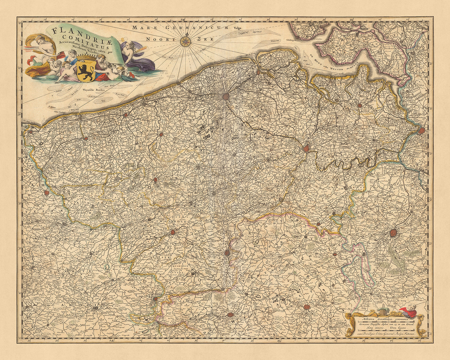


Old Map of Flanders by Visscher, 1690: Brussels, Antwerp, Ghent, Bruges, Scarpe-Escaut Park
Buy 2, Get 1 More Free
If you add 2 items to your bag, you can add a third product for free. The discount is automatic - no code required.
This is equivalent to 33% off, which will be the largest discount available on my shop this year.
This works for all maps and artwork. You can order 3 of the same thing, or 3 different things.
Custom maps are excluded, as they're too time consuming to make and we'd prefer to take our time rather than rush through a lot of orders.
Contact me if you have any questions.
- All taxes and duties included
- Handmade & dispatched in 1-2 days
-
Complimentary gifting & design advice
ⓘ
Complimentary gifting & design advice
Available almost 24/7 on WhatsApp and email — we usually reply within minutes. We can help you:
- Choose a perfectly personalised gift
- Send a digital gift preview to the recipient
- Pick the ideal size for your wall
- Select the right finish and frame
Quick, friendly advice so you can order with confidence.
For last minute gifts, consider buying a digital gift card. We have over 5,000 maps and art prints to choose from.
-
90-day returns & 5-year guarantee
ⓘ
90-day returns & 5-year guarantee
Products can be returned within 90 days for a full refund, or exchange for another product.
We are also proud to offer a 5-year quality guarantee on our maps and art, covering defects in materials or workmanship under normal use.
For personalised and custom made items, we may offer you store credit or a non-expiring gift card, as we cannot resell personalised orders.
If you have any questions, get in touch. For more information, see our full returns & exchanges policy.

This is a museum-grade archival print from the original 1690 map — restored in our workshop and made to order on 220gsm archival matte paper or 400gsm artist's cotton canvas with pigment inks.
Professional framing & free personalisation available
1. Choose a size
2. Frame & personalise your map
Make your map unique with framing, hand-drawn customisation, vintage ageing, pop art text, unique 3D styling and more.


Gift message & custom finish

If you want to add a gift message, or a finish (jigsaw, aluminium board, etc.) that is not available here, please request it in the "order note" when you check out.
Every order is custom made, so if you need the size adjusted slightly, or printed on an unusual material, just let us know. We've done thousands of custom orders over the years, so there's (almost) nothing we can't manage.
You can also contact us before you order, if you prefer!

- Handmade locally. No import duty or tax
- FREE worldwide delivery
- 90-day returns & 5-year product guarantee
- Questions? WhatsApp me any time
Own a piece of history
7,000+ 5 star reviews


Step back in time with this meticulously detailed map of Flanders, crafted by the renowned mapmaker Nicolaes Visscher II in 1690. This map, originally titled 'Flandriae Comitatus: Accuratissima Descriptio edita', or 'The Most Accurate Description of the County of Flanders', offers a rich tapestry of the historical and geographical landscape of what is now a significant part of Belgium.
The map prominently features the city of Brussels, a historical and political powerhouse that has been the de facto capital of the European Union. It also highlights Antwerp, a city known for its long-standing diamond trade and its pivotal role in the world's economy during the Age of Exploration. Ghent, another city of great historical significance, is also showcased, with its medieval architecture and the famous Saint Bavo's Cathedral.
Moving westward, the map presents Bruges, a city often referred to as the 'Venice of the North' due to its intricate network of canals. This UNESCO World Heritage city, known for its well-preserved medieval buildings, adds a touch of romantic allure to the map. The Scarpe-Escaut Regional Nature Park, the first cross-border nature park in France and Belgium, is also represented, offering a glimpse into the region's natural beauty and biodiversity.
This map provides a unique opportunity to explore the rich tapestry of Flanders as it was in the late 17th century. It serves as a testament to the region's historical importance and the intricate cartographic skills of Nicolaes Visscher II. Whether you're a history enthusiast, a lover of maps, or simply someone who appreciates the beauty of old-world craftsmanship, this map of Flanders is sure to be a captivating addition to your collection.
Some of the significant locations shown on this map:
Cities and Towns:
- Brussels: Known as Bruxelles in French and Brussel in Dutch, it's the capital city of Belgium and a significant center for international politics.
- Antwerp: Historically known as Antwerpen in Dutch, it's famous for its diamond trade and port, one of the largest in the world.
- Ghent: Known as Gent in Dutch, it's a city of rich history, home to Saint Bavo's Cathedral and Gravensteen castle.
- Bruges: Known as Brugge in Dutch, it's famous for its medieval architecture and network of canals.
- Leuven: Known for its historic university, Katholieke Universiteit Leuven, founded in 1425.
- Namur: The capital of Wallonia, it has a significant strategic location at the confluence of the Meuse and Sambre rivers.
- Mechelen: Known for its carillon school, where the art of bell-ringing is taught.
- Ostend: Known as Oostende in Dutch, it's a significant port and tourist destination on the Belgian coast.
- Kortrijk: Known for the Battle of the Golden Spurs in 1302, which was a significant event in the Flemish fight for independence.
- Tournai: One of the oldest cities in Belgium, it's known for its impressive Cathedral of Our Lady.
- Ypres: Known as Ieper in Dutch, it's famous for its involvement in World War I.
- Hasselt: Known for its jenever, a strong juniper-flavored liquor.
- Aalst: Famous for its annual carnival procession.
- Mons: Known as Bergen in Dutch, it's the capital of Hainaut province.
- Charleroi: Known for its historical importance in the coal industry.
- Liège: A significant cultural center in Wallonia, known for its vibrant nightlife.
- Verviers: Known for its former importance in the wool and textile industry.
- Sint-Niklaas: Known for having the largest market square in Belgium.
- Roeselare: Known for its association with the Flemish cycling tradition.
- Genk: Known for its multicultural demographic, as a result of immigration from the mining industry.
- Lokeren: Known for its annual Lokerse Feesten music festival.
- Dendermonde: Known for its decennial procession of the Ros Beiaard, a large horse-drawn figure from local folklore.
- Beringen: Known for its coal mine, now a museum and tourist destination.
- Turnhout: Known as the "capital of the playing card" for its historical production of playing cards.
- Vilvoorde: Known for its central location between Brussels and Antwerp.
- Herentals: Known as the "city of the three spires" for its three historical churches.
- Maaseik: Known for its well-preserved medieval buildings.
- Wavre: Known as Waver in Dutch, it's the capital of Walloon Brabant province.
- Binche: Known for its traditional carnival, recognized as a Masterpiece of the Oral and Intangible Heritage of Humanity by UNESCO.
- Ronse: Known as Renaix in French, it's known for its textile industry and folklore.
Natural Landmarks:
- Scarpe-Escaut Regional Nature Park: The first cross-border nature park in France and Belgium.
- The Meuse River: One of the major rivers in Europe, flowing through France, Belgium, and the Netherlands.
- The Scheldt River: An important waterway that flows through northern France, western Belgium, and the southwestern part of the Netherlands.
- The Ardennes: A region of extensive forests, rolling hills, and ridges.
- The North Sea: A marginal sea of the Atlantic Ocean, providing a northern border for Belgium.
Historical Events:
- The Eighty Years' War (1568-1648): A revolt of the Seventeen Provinces against the political and religious hegemony of Philip II of Spain.
- The Treaty of Münster (1648): Part of the Peace of Westphalia, it recognized the independence of the Dutch Republic.
- The Franco-Dutch War (1672–1678): Also known as the Dutch War, it was a conflict between France and the Dutch Republic, with England, Sweden, and several German states as France's allies.
Please double check the images to make sure that a specific town or place is shown on this map. You can also get in touch and ask us to check the map for you.
This map looks great at all sizes: 12x16in (30.5x41cm), 16x20in (40.5x51cm), 18x24in (45.5x61cm), 24x30in (61x76cm), 32x40in (81.5x102cm), 40x50in (102x127cm), 48x60in (122x153cm) and 56x70in (142x178cm), but it looks even better when printed large.
I can create beautiful, large prints of this map up to 90in (229cm). Please get in touch if you're looking for larger, customised or different framing options.
The model in the listing images is holding the 16x20in (40.5x51cm) version of this map.
The fifth listing image shows an example of my map personalisation service.
The labels on this map are very small at 12x16in (30.5x41cm). The map is still very attractive, but you may struggle to read the smallest letters. Please buy a larger map if it's important to be able to read the map easily.
If you’re looking for something slightly different, check out my collection of the best old maps of Europe and European cities to see if something else catches your eye.
Please contact me to check if a certain location, landmark or feature is shown on this map.
This would make a wonderful birthday, Christmas, Father's Day, work leaving, anniversary or housewarming gift for someone from the areas covered by this map.
This map is available as a giclée print on acid free archival matte paper, or you can buy it framed. The frame is a nice, simple black frame that suits most aesthetics. Please get in touch if you'd like a different frame colour or material. My frames are glazed with super-clear museum-grade acrylic (perspex/acrylite), which is significantly less reflective than glass, safer, and will always arrive in perfect condition.
This map is also available as a float framed canvas, sometimes known as a shadow gap framed canvas or canvas floater. The map is printed on artist's cotton canvas and then stretched over a handmade box frame. We then "float" the canvas inside a wooden frame, which is available in a range of colours (black, dark brown, oak, antique gold and white). This is a wonderful way to present a map without glazing in front. See some examples of float framed canvas maps and explore the differences between my different finishes.
For something truly unique, this map is also available in "Unique 3D", our trademarked process that dramatically transforms the map so that it has a wonderful sense of depth. We combine the original map with detailed topography and elevation data, so that mountains and the terrain really "pop". For more info and examples of 3D maps, check my Unique 3D page.
For most orders, delivery time is about 3 working days. Personalised and customised products take longer, as I have to do the personalisation and send it to you for approval, which usually takes 1 or 2 days.
Please note that very large framed orders usually take longer to make and deliver.
If you need your order to arrive by a certain date, please contact me before you order so that we can find the best way of making sure you get your order in time.
I print and frame maps and artwork in 23 countries around the world. This means your order will be made locally, which cuts down on delivery time and ensures that it won't be damaged during delivery. You'll never pay customs or import duty, and we'll put less CO2 into the air.
All of my maps and art prints are well packaged and sent in a rugged tube if unframed, or surrounded by foam if framed.
I try to send out all orders within 1 or 2 days of receiving your order, though some products (like face masks, mugs and tote bags) can take longer to make.
If you select Express Delivery at checkout your order we will prioritise your order and send it out by 1-day courier (Fedex, DHL, UPS, Parcelforce).
Next Day delivery is also available in some countries (US, UK, Singapore, UAE) but please try to order early in the day so that we can get it sent out on time.
My standard frame is a gallery style black ash hardwood frame. It is simple and quite modern looking. My standard frame is around 20mm (0.8in) wide.
I use super-clear acrylic (perspex/acrylite) for the frame glass. It's lighter and safer than glass - and it looks better, as the reflectivity is lower.
Six standard frame colours are available for free (black, dark brown, dark grey, oak, white and antique gold). Custom framing and mounting/matting is available if you're looking for something else.
Most maps, art and illustrations are also available as a framed canvas. We use matte (not shiny) cotton canvas, stretch it over a sustainably sourced box wood frame, and then 'float' the piece within a wood frame. The end result is quite beautiful, and there's no glazing to get in the way.
All frames are provided "ready to hang", with either a string or brackets on the back. Very large frames will have heavy duty hanging plates and/or a mounting baton. If you have any questions, please get in touch.
See some examples of my framed maps and framed canvas maps.
Alternatively, I can also supply old maps and artwork on canvas, foam board, cotton rag and other materials.
If you want to frame your map or artwork yourself, please read my size guide first.
My maps are extremely high quality reproductions of original maps.
I source original, rare maps from libraries, auction houses and private collections around the world, restore them at my London workshop, and then use specialist giclée inks and printers to create beautiful maps that look even better than the original.
My maps are printed on acid-free archival matte (not glossy) paper that feels very high quality and almost like card. In technical terms the paper weight/thickness is 10mil/200gsm. It's perfect for framing.
I print with Epson ultrachrome giclée UV fade resistant pigment inks - some of the best inks you can find.
I can also make maps on canvas, cotton rag and other exotic materials.
Learn more about The Unique Maps Co.
Map personalisation
If you're looking for the perfect anniversary or housewarming gift, I can personalise your map to make it truly unique. For example, I can add a short message, or highlight an important location, or add your family's coat of arms.
The options are almost infinite. Please see my map personalisation page for some wonderful examples of what's possible.
To order a personalised map, select "personalise your map" before adding it to your basket.
Get in touch if you're looking for more complex customisations and personalisations.
Map ageing
I have been asked hundreds of times over the years by customers if they could buy a map that looks even older.
Well, now you can, by selecting Aged before you add a map to your basket.
All the product photos you see on this page show the map in its Original form. This is what the map looks like today.
If you select Aged, I will age your map by hand, using a special and unique process developed through years of studying old maps, talking to researchers to understand the chemistry of aging paper, and of course... lots of practice!
If you're unsure, stick to the Original colour of the map. If you want something a bit darker and older looking, go for Aged.
If you are not happy with your order for any reason, contact me and I'll get it fixed ASAP, free of charge. Please see my returns and refund policy for more information.
I am very confident you will like your restored map or art print. I have been doing this since 1984. I'm a 5-star Etsy seller. I have sold tens of thousands of maps and art prints and have over 5,000 real 5-star reviews. My work has been featured in interior design magazines, on the BBC, and on the walls of dozens of 5-star hotels.
I use a unique process to restore maps and artwork that is massively time consuming and labour intensive. Hunting down the original maps and illustrations can take months. I use state of the art and eye-wateringly expensive technology to scan and restore them. As a result, I guarantee my maps and art prints are a cut above the rest. I stand by my products and will always make sure you're 100% happy with what you receive.
Almost all of my maps and art prints look amazing at large sizes (200cm, 6.5ft+) and I can frame and deliver them to you as well, via special oversized courier. Contact me to discuss your specific needs.
Or try searching for something!


