

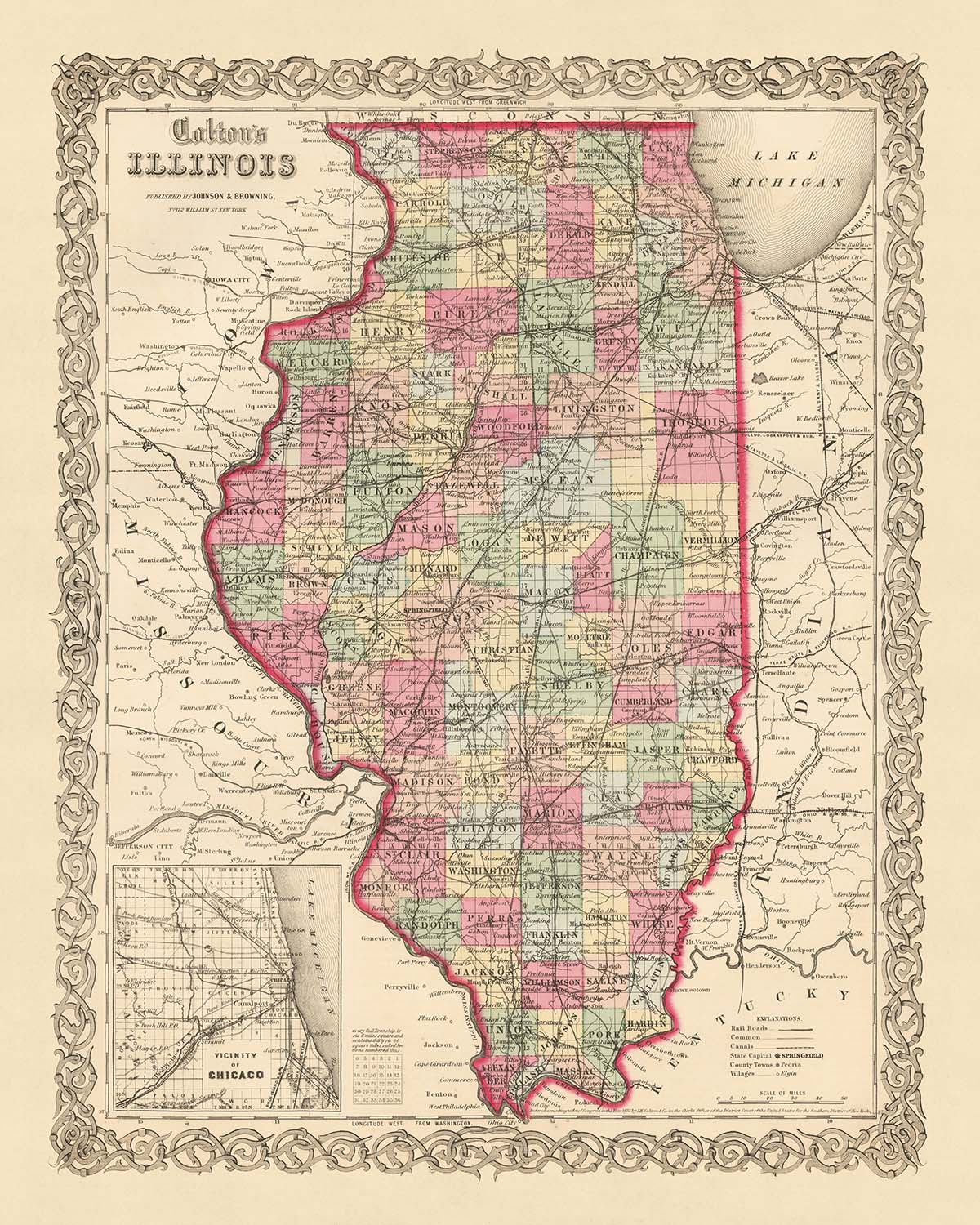


Old map of Illinois by J. H. Colton, 1855: Chicago, Peoria, Springfield, Galena, Quincy
Buy 2, Get 1 More Free
If you add 2 items to your bag, you can add a third product for free. The discount is automatic - no code required.
This is equivalent to 33% off, which will be the largest discount available on my shop this year.
This works for all maps and artwork. You can order 3 of the same thing, or 3 different things.
Custom maps are excluded, as they're too time consuming to make and we'd prefer to take our time rather than rush through a lot of orders.
Contact me if you have any questions.
- All taxes and duties included
- Handmade & dispatched in 1-2 days
-
Complimentary gifting & design advice
ⓘ
Complimentary gifting & design advice
Available almost 24/7 on WhatsApp and email — we usually reply within minutes. We can help you:
- Choose a perfectly personalised gift
- Send a digital gift preview to the recipient
- Pick the ideal size for your wall
- Select the right finish and frame
Quick, friendly advice so you can order with confidence.
For last minute gifts, consider buying a digital gift card. We have over 5,000 maps and art prints to choose from.
-
90-day returns & 5-year guarantee
ⓘ
90-day returns & 5-year guarantee
Products can be returned within 90 days for a full refund, or exchange for another product.
We are also proud to offer a 5-year quality guarantee on our maps and art, covering defects in materials or workmanship under normal use.
For personalised and custom made items, we may offer you store credit or a non-expiring gift card, as we cannot resell personalised orders.
If you have any questions, get in touch. For more information, see our full returns & exchanges policy.

This is a museum-grade archival print from the original 1855 map — restored in our workshop and made to order on 220gsm archival matte paper or 400gsm artist's cotton canvas with pigment inks.
Professional framing & free personalisation available
1. Choose a size
2. Frame & personalise your map
Make your map unique with framing, hand-drawn customisation, vintage ageing, pop art text, unique 3D styling and more.


Gift message & custom finish

If you want to add a gift message, or a finish (jigsaw, aluminium board, etc.) that is not available here, please request it in the "order note" when you check out.
Every order is custom made, so if you need the size adjusted slightly, or printed on an unusual material, just let us know. We've done thousands of custom orders over the years, so there's (almost) nothing we can't manage.
You can also contact us before you order, if you prefer!

- Handmade locally. No import duty or tax
- FREE worldwide delivery
- 90-day returns & 5-year product guarantee
- Questions? WhatsApp me any time
Own a piece of history
7,000+ 5 star reviews


Step back in time with this exquisite 1855 map of Illinois, meticulously crafted by the renowned mapmaker, J. H. Colton. As one of the finest American mapmakers of his era, Colton's maps are known for their accuracy and attention to detail. This particular map offers a unique glimpse into the history of Illinois, a region that was still in its early stages of development during the mid-19th century.
The map is a testament to the pioneering spirit of the United States in the 1850s. At this point in history, many settlements had yet to be founded and the landscape was in a constant state of flux. The map reflects this sense of change and growth, with many names and borders likely having changed in the intervening 150 years. The map serves as a snapshot of a moment in time, offering insights into the early development of Illinois and the United States as a whole.
The settlements of Chicago, Peoria, Springfield, Galena, and Quincy are prominently featured, providing a fascinating look at the early urban centers of Illinois. These settlements played a crucial role in the state's history and development, and their inclusion in this map underscores their importance. Whether you're a history enthusiast, a map collector, or simply someone who appreciates fine craftsmanship, this map is sure to captivate and inspire.
J. H. Colton's 1855 map of Illinois is more than just a historical artifact - it's a window into the past, a tool for understanding how the United States has evolved over time. With its meticulous detailing and historical significance, this map is a must-have for any serious collector or history enthusiast. Explore the early days of Illinois and the United States with this remarkable piece of cartographic history.
Notable Settlements in Illinois (Pre-1855)
- Chicago (1833): Known as the "Windy City", it quickly grew from a small settlement to a bustling metropolis due to its strategic location near the Great Lakes and the Illinois River.
- Peoria (1691): Originally a French fort named Fort St. Louis du Pimiteoui, it's one of the oldest European settlements in Illinois.
- Springfield (1819): Known as Calhoun until 1832, it became the state capital in 1837.
- Galena (1826): A major port on the Mississippi River, it was a hub for steamboat traffic and the lead mining industry.
- Quincy (1822): Known for its German immigrant population and as a stop on the Underground Railroad.
- Cahokia (1699): Originally a French colonial town known as the Holy Family, it's the oldest continuously inhabited European settlement in the Midwest.
- Alton (1818): Known for its limestone bluffs along the Mississippi River and as a site of abolitionist activity.
- Nauvoo (1839): Established by Mormons fleeing persecution, it was once the largest city in Illinois.
- Rock Island (1835): Named for an island in the Mississippi River, it's known for the Rock Island Arsenal, a major US Army facility.
- Belleville (1814): Known for its German heritage and as the birthplace of the St. Louis Browns baseball team.
- Decatur (1829): Known as the "Soybean Capital of the World" and the original home of the Chicago Bears.
- Elgin (1835): Known for its dairy industry and the Elgin National Watch Company.
- Kaskaskia (1703): The first capital of Illinois, it was a significant French colonial town.
- Shawneetown (1748): Known as the "Gateway to the West", it was a major port on the Ohio River.
- LaSalle (1837): Named after the French explorer, it was a major coal mining center.
- Bloomington (1822): Known for its agriculture and as the birthplace of the Illinois Republican Party.
- Joliet (1834): Known for its limestone quarries and as the home of the Joliet Prison.
- Carbondale (1852): Known for its railroads and as the home of Southern Illinois University.
- Galesburg (1837): Known for its railroads and as the birthplace of poet Carl Sandburg.
- Evanston (1854): Known for its temperance movement and as the home of Northwestern University.
Native American Tribes in Illinois (Pre-1855)
- Illiniwek Confederation: A group of 12-13 tribes speaking Algonquin languages, they were the dominant group in Illinois until the mid-18th century.
- Miami Tribe: Known for their intricate beadwork and pottery.
- Kickapoo Tribe: They migrated to Illinois in the 18th century, known for their resistance against American expansion.
- Potawatomi Tribe: Known for their farming and trading, they were forcibly removed from Illinois in the 1830s.
Notable Natural Features in Illinois (Pre-1855)
- Mississippi River: A major transportation route for both Native Americans and European settlers.
- Illinois River: An important waterway for trade and transportation.
- Starved Rock State Park: Known for its canyons and waterfalls, it's a popular tourist destination today.
- Shawnee National Forest: Known for its unique rock formations and diverse plant and animal life.
Historical Events in Illinois (1810-1855)
- Black Hawk War (1832): A brief conflict between the United States and Native Americans led by Black Hawk, a Sauk leader.
- Illinois becomes the 21st state (1818): Illinois was admitted to the Union on December 3, 1818.
- Construction of the Illinois and Michigan Canal (1836-1848): This canal connected the Great Lakes to the Mississippi River, boosting Chicago's growth.
- The Mormon Exodus (1846): The departure of the Latter Day Saints from Nauvoo to Utah.
- Galena Lead Rush (1820s-1850s): A period of intense lead mining in and around Galena, leading to rapid population growth.
Please double check the images to make sure that a specific town or place is shown on this map. You can also get in touch and ask us to check the map for you.
This map looks great at all sizes: 12x16in (30.5x41cm), 16x20in (40.5x51cm), 18x24in (45.5x61cm), 24x30in (61x76cm), 32x40in (81.5x102cm), 40x50in (102x127cm), 48x60in (122x153cm) and 56x70in (142x178cm), but it looks even better when printed large.
I can create beautiful, large prints of this map up to 70in (178cm). Please get in touch if you're looking for larger, customised or different framing options.
The model in the listing images is holding the 16x20in (40.5x51cm) version of this map.
The fifth listing image shows an example of my map personalisation service.
If you’re looking for something slightly different, check out my main collection of USA and North America maps.
Please contact me to check if a certain location, landmark or feature is shown on this map.
This would make a wonderful birthday, Christmas, Father's Day, work leaving, anniversary or housewarming gift for someone from the areas covered by this map.
This map is available as a giclée print on acid free archival matte paper, or you can buy it framed. The frame is a nice, simple black frame that suits most aesthetics. Please get in touch if you'd like a different frame colour or material. My frames are glazed with super-clear museum-grade acrylic (perspex/acrylite), which is significantly less reflective than glass, safer, and will always arrive in perfect condition.
This map is also available as a float framed canvas, sometimes known as a shadow gap framed canvas or canvas floater. The map is printed on artist's cotton canvas and then stretched over a handmade box frame. We then "float" the canvas inside a wooden frame, which is available in a range of colours (black, dark brown, oak, antique gold and white). This is a wonderful way to present a map without glazing in front. See some examples of float framed canvas maps and explore the differences between my different finishes.
For something truly unique, this map is also available in "Unique 3D", our trademarked process that dramatically transforms the map so that it has a wonderful sense of depth. We combine the original map with detailed topography and elevation data, so that mountains and the terrain really "pop". For more info and examples of 3D maps, check my Unique 3D page.
For most orders, delivery time is about 3 working days. Personalised and customised products take longer, as I have to do the personalisation and send it to you for approval, which usually takes 1 or 2 days.
Please note that very large framed orders usually take longer to make and deliver.
If you need your order to arrive by a certain date, please contact me before you order so that we can find the best way of making sure you get your order in time.
I print and frame maps and artwork in 23 countries around the world. This means your order will be made locally, which cuts down on delivery time and ensures that it won't be damaged during delivery. You'll never pay customs or import duty, and we'll put less CO2 into the air.
All of my maps and art prints are well packaged and sent in a rugged tube if unframed, or surrounded by foam if framed.
I try to send out all orders within 1 or 2 days of receiving your order, though some products (like face masks, mugs and tote bags) can take longer to make.
If you select Express Delivery at checkout your order we will prioritise your order and send it out by 1-day courier (Fedex, DHL, UPS, Parcelforce).
Next Day delivery is also available in some countries (US, UK, Singapore, UAE) but please try to order early in the day so that we can get it sent out on time.
My standard frame is a gallery style black ash hardwood frame. It is simple and quite modern looking. My standard frame is around 20mm (0.8in) wide.
I use super-clear acrylic (perspex/acrylite) for the frame glass. It's lighter and safer than glass - and it looks better, as the reflectivity is lower.
Six standard frame colours are available for free (black, dark brown, dark grey, oak, white and antique gold). Custom framing and mounting/matting is available if you're looking for something else.
Most maps, art and illustrations are also available as a framed canvas. We use matte (not shiny) cotton canvas, stretch it over a sustainably sourced box wood frame, and then 'float' the piece within a wood frame. The end result is quite beautiful, and there's no glazing to get in the way.
All frames are provided "ready to hang", with either a string or brackets on the back. Very large frames will have heavy duty hanging plates and/or a mounting baton. If you have any questions, please get in touch.
See some examples of my framed maps and framed canvas maps.
Alternatively, I can also supply old maps and artwork on canvas, foam board, cotton rag and other materials.
If you want to frame your map or artwork yourself, please read my size guide first.
My maps are extremely high quality reproductions of original maps.
I source original, rare maps from libraries, auction houses and private collections around the world, restore them at my London workshop, and then use specialist giclée inks and printers to create beautiful maps that look even better than the original.
My maps are printed on acid-free archival matte (not glossy) paper that feels very high quality and almost like card. In technical terms the paper weight/thickness is 10mil/200gsm. It's perfect for framing.
I print with Epson ultrachrome giclée UV fade resistant pigment inks - some of the best inks you can find.
I can also make maps on canvas, cotton rag and other exotic materials.
Learn more about The Unique Maps Co.
Map personalisation
If you're looking for the perfect anniversary or housewarming gift, I can personalise your map to make it truly unique. For example, I can add a short message, or highlight an important location, or add your family's coat of arms.
The options are almost infinite. Please see my map personalisation page for some wonderful examples of what's possible.
To order a personalised map, select "personalise your map" before adding it to your basket.
Get in touch if you're looking for more complex customisations and personalisations.
Map ageing
I have been asked hundreds of times over the years by customers if they could buy a map that looks even older.
Well, now you can, by selecting Aged before you add a map to your basket.
All the product photos you see on this page show the map in its Original form. This is what the map looks like today.
If you select Aged, I will age your map by hand, using a special and unique process developed through years of studying old maps, talking to researchers to understand the chemistry of aging paper, and of course... lots of practice!
If you're unsure, stick to the Original colour of the map. If you want something a bit darker and older looking, go for Aged.
If you are not happy with your order for any reason, contact me and I'll get it fixed ASAP, free of charge. Please see my returns and refund policy for more information.
I am very confident you will like your restored map or art print. I have been doing this since 1984. I'm a 5-star Etsy seller. I have sold tens of thousands of maps and art prints and have over 5,000 real 5-star reviews. My work has been featured in interior design magazines, on the BBC, and on the walls of dozens of 5-star hotels.
I use a unique process to restore maps and artwork that is massively time consuming and labour intensive. Hunting down the original maps and illustrations can take months. I use state of the art and eye-wateringly expensive technology to scan and restore them. As a result, I guarantee my maps and art prints are a cut above the rest. I stand by my products and will always make sure you're 100% happy with what you receive.
Almost all of my maps and art prints look amazing at large sizes (200cm, 6.5ft+) and I can frame and deliver them to you as well, via special oversized courier. Contact me to discuss your specific needs.
Or try searching for something!


