

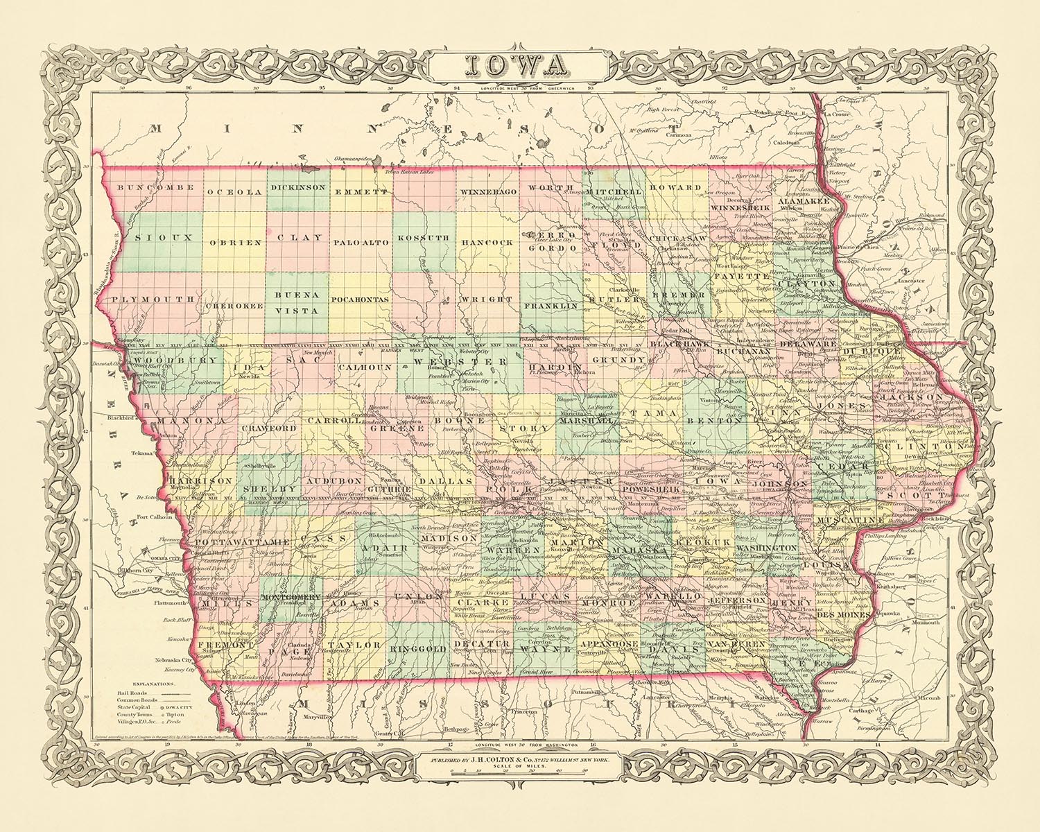
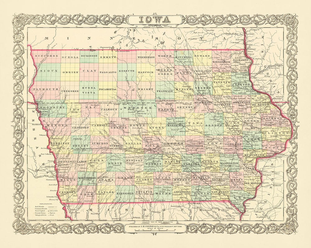


Old map of Iowa by J. H. Colton, 1856: Des Moines, Iowa City, Dubuque, Davenport, Burlington
- All taxes and duties included
- Handmade & dispatched in 1-2 days
-
FREE gift preview
ⓘ
Digital gift preview
New for 2025: After you complete your order, you can send a beautiful digital preview to the gift recipient. Just provide their email address and we'll do the rest. (Their email address will not be stored or used for any other purpose.)
This is perfect for Christmas gifting, particularly if you're concerned that your order might not arrive in time for Christmas.
-
90 day money back guarantee
ⓘ
90 days to return and refund
Products can be returned within 90 days for a full refund, or exchange for another product.
For personalised and custom made items, we may offer you store credit or a non-expiring gift card, as we cannot resell personalised orders.
If you have any questions, get in touch. For more information, see our full returns & exchanges policy.

My maps are rare, museum-grade, restored old maps sourced from libraries, auction houses and private collections across the globe.
Framing & free personalisation available
1. Select your size
2. Frame & personalise your map
There is limited framing & personalisation capacity available. Order by 10am tomorrow for Christmas delivery.


Gift message & custom finish

If you want to add a gift message, or a finish (jigsaw, aluminium board, etc.) that is not available here, please request it in the "order note" when you check out.
Every order is custom made, so if you need the size adjusted slightly, or printed on an unusual material, just let us know. We've done thousands of custom orders over the years, so there's (almost) nothing we can't manage.
You can also contact us before you order, if you prefer!

- Handmade locally. No import duty or tax
- FREE Delivery by Christmas
- Love it or your money back (90 days)
- Questions? WhatsApp me any time
Own a piece of history
5,000+ 5 star reviews


Immerse yourself in the rich history of the United States with this meticulously crafted old map of Iowa from 1856, published by the esteemed mapmaker J. H. Colton. This piece offers a unique glimpse into the nation's past, at a time when many settlements were still in their infancy, and the borders and names we are familiar with today were still evolving. This map is a testament to the country's dynamic history, offering a snapshot of a time that has been etched into the annals of American history.
J. H. Colton, the mapmaker behind this work, is widely regarded as one of the finest American mapmakers of his era. His attention to detail and commitment to accuracy are evident in this map of Iowa, providing a precise representation of the region as it was in the mid-19th century. Colton's maps are renowned for their intricacy and precision, and this map of Iowa is no exception. It is a testament to his skill and dedication, making it a truly exceptional piece for any collector or history enthusiast.
This map of Iowa from 1856 is from a time when the United States was still very young. Many of the settlements that we know today had not yet been founded, and the names and borders that are now familiar to us were still in flux. The map features the five most notable settlements in Iowa at the time: Des Moines, Iowa City, Dubuque, Davenport, and Burlington. These settlements, some of which have grown into major cities today, provide a fascinating insight into the early development of the region.
The map offers a detailed view of the region, with each settlement marked and labeled. The level of detail allows you to trace the growth and development of these settlements over time, providing a tangible link to the past. The map also features the natural geography of the region, including rivers and other landmarks, providing a comprehensive view of the region as it was in 1856.
This old map of Iowa by J. H. Colton is more than just a historical artifact. It is a piece of art, a window into the past, and a testament to the skill and dedication of one of America's finest mapmakers. Whether you are a history buff, a collector, or simply someone who appreciates fine craftsmanship, this map is sure to be a treasured addition to your collection.
Notable Settlements in Iowa (Founded before 1856)
- Des Moines (1843): Known as Fort Des Moines until 1857, it became the state capital in 1858. It's notable for its role in the insurance industry and as the headquarters for many national political campaigns.
- Iowa City (1839): The original state capital of Iowa, it's home to the University of Iowa, one of the oldest and most prestigious public universities in the U.S.
- Dubuque (1833): Named after French-Canadian fur trader Julien Dubuque, it's known for its rich mining and river trading history.
- Davenport (1836): Named after Colonel George Davenport, it's recognized for its historic architecture and vibrant arts scene.
- Burlington (1833): Known as Flint Hills until 1834, it's famous for its Snake Alley, once labelled the most crooked street in the world.
- Keokuk (1837): Named after the Sauk chief Keokuk, it's notable for its historic role in the American Civil War.
- Fort Madison (1808): The site of the first U.S. military fort on the Upper Mississippi, it's known for its historic architecture and the annual Tri-State Rodeo.
- Muscatine (1833): Known as Bloomington until 1849, it's famous for its pearl button manufacturing history.
- Council Bluffs (1837): Known as Kanesville until 1852, it's notable as a starting point for Mormon pioneers heading west.
- Sioux City (1854): Named after the Sioux tribe, it's recognized for its rich agricultural history.
- Clinton (1835): Known for its lumber mills and as the eastern terminus of the Lincoln Highway, the first transcontinental highway.
- Marion (1839): Named after Revolutionary War hero Francis Marion, it's known for its historic buildings and annual Swamp Fox Festival.
- Bettendorf (1844): Part of the Quad Cities, it's known for its high quality of life and strong school system.
- Oskaloosa (1844): Named after a Creek princess, it's notable for its coal mining history.
- Fairfield (1839): Known for its vibrant arts scene and as the home of Maharishi University of Management.
- Mount Pleasant (1835): Known for its historic architecture and the annual Midwest Old Thresher's Reunion.
- Ottumwa (1843): Known as the "City of Bridges" for its numerous bridges over the Des Moines River.
- Decorah (1849): Known for its Norwegian-American culture and the annual Nordic Fest.
- Pella (1847): Known for its Dutch heritage and the annual Tulip Time festival.
- Le Claire (1834): Known for its historic downtown and as the home of the American Pickers television show.
Indian Tribes and Territories
- Meskwaki Tribe: Known as the "Red Earth People", they are the only federally recognized tribe in Iowa.
- Sauk Tribe: Known for their warrior society and their notable chief, Black Hawk.
- Sioux Tribe: Known for their hunting and warrior culture.
Notable Natural Phenomena
- Mississippi River: The largest river system in North America, it's a major route for trade and travel.
- Des Moines River: A major tributary of the Mississippi River, it's known for its recreational opportunities.
- Loess Hills: Unique formations of wind-deposited soil, they are a National Natural Landmark.
- Effigy Mounds National Monument: Prehistoric mounds built by Native Americans, they are a major archaeological site.
Historical Events (1810-1856)
- Black Hawk War (1832): A brief conflict between the United States and Native Americans led by Black Hawk, a Sauk leader.
- Iowa becomes a state (1846): Iowa was admitted to the Union as the 29th state on December 28, 1846.
- First Iowa State Fair (1854): The first state fair was held in Fairfield in 1854, showcasing the state's agricultural achievements.
Please double check the images to make sure that a specific town or place is shown on this map. You can also get in touch and ask us to check the map for you.
This map looks great at all sizes: 12x16in (30.5x41cm), 16x20in (40.5x51cm), 18x24in (45.5x61cm), 24x30in (61x76cm), 32x40in (81.5x102cm), 40x50in (102x127cm), 48x60in (122x153cm) and 56x70in (142x178cm), but it looks even better when printed large.
I can create beautiful, large prints of this map up to 70in (178cm). Please get in touch if you're looking for larger, customised or different framing options.
The model in the listing images is holding the 16x20in (40.5x51cm) version of this map.
The fifth listing image shows an example of my map personalisation service.
If you’re looking for something slightly different, check out my main collection of USA and North America maps.
Please contact me to check if a certain location, landmark or feature is shown on this map.
This would make a wonderful birthday, Christmas, Father's Day, work leaving, anniversary or housewarming gift for someone from the areas covered by this map.
This map is available as a giclée print on acid free archival matte paper, or you can buy it framed. The frame is a nice, simple black frame that suits most aesthetics. Please get in touch if you'd like a different frame colour or material. My frames are glazed with super-clear museum-grade acrylic (perspex/acrylite), which is significantly less reflective than glass, safer, and will always arrive in perfect condition.
This map is also available as a float framed canvas, sometimes known as a shadow gap framed canvas or canvas floater. The map is printed on artist's cotton canvas and then stretched over a handmade box frame. We then "float" the canvas inside a wooden frame, which is available in a range of colours (black, dark brown, oak, antique gold and white). This is a wonderful way to present a map without glazing in front. See some examples of float framed canvas maps and explore the differences between my different finishes.
For something truly unique, this map is also available in "Unique 3D", our trademarked process that dramatically transforms the map so that it has a wonderful sense of depth. We combine the original map with detailed topography and elevation data, so that mountains and the terrain really "pop". For more info and examples of 3D maps, check my Unique 3D page.
For most orders, delivery time is about 3 working days. Personalised and customised products take longer, as I have to do the personalisation and send it to you for approval, which usually takes 1 or 2 days.
Please note that very large framed orders usually take longer to make and deliver.
If you need your order to arrive by a certain date, please contact me before you order so that we can find the best way of making sure you get your order in time.
I print and frame maps and artwork in 23 countries around the world. This means your order will be made locally, which cuts down on delivery time and ensures that it won't be damaged during delivery. You'll never pay customs or import duty, and we'll put less CO2 into the air.
All of my maps and art prints are well packaged and sent in a rugged tube if unframed, or surrounded by foam if framed.
I try to send out all orders within 1 or 2 days of receiving your order, though some products (like face masks, mugs and tote bags) can take longer to make.
If you select Express Delivery at checkout your order we will prioritise your order and send it out by 1-day courier (Fedex, DHL, UPS, Parcelforce).
Next Day delivery is also available in some countries (US, UK, Singapore, UAE) but please try to order early in the day so that we can get it sent out on time.
My standard frame is a gallery style black ash hardwood frame. It is simple and quite modern looking. My standard frame is around 20mm (0.8in) wide.
I use super-clear acrylic (perspex/acrylite) for the frame glass. It's lighter and safer than glass - and it looks better, as the reflectivity is lower.
Six standard frame colours are available for free (black, dark brown, dark grey, oak, white and antique gold). Custom framing and mounting/matting is available if you're looking for something else.
Most maps, art and illustrations are also available as a framed canvas. We use matte (not shiny) cotton canvas, stretch it over a sustainably sourced box wood frame, and then 'float' the piece within a wood frame. The end result is quite beautiful, and there's no glazing to get in the way.
All frames are provided "ready to hang", with either a string or brackets on the back. Very large frames will have heavy duty hanging plates and/or a mounting baton. If you have any questions, please get in touch.
See some examples of my framed maps and framed canvas maps.
Alternatively, I can also supply old maps and artwork on canvas, foam board, cotton rag and other materials.
If you want to frame your map or artwork yourself, please read my size guide first.
My maps are extremely high quality reproductions of original maps.
I source original, rare maps from libraries, auction houses and private collections around the world, restore them at my London workshop, and then use specialist giclée inks and printers to create beautiful maps that look even better than the original.
My maps are printed on acid-free archival matte (not glossy) paper that feels very high quality and almost like card. In technical terms the paper weight/thickness is 10mil/200gsm. It's perfect for framing.
I print with Epson ultrachrome giclée UV fade resistant pigment inks - some of the best inks you can find.
I can also make maps on canvas, cotton rag and other exotic materials.
Learn more about The Unique Maps Co.
Map personalisation
If you're looking for the perfect anniversary or housewarming gift, I can personalise your map to make it truly unique. For example, I can add a short message, or highlight an important location, or add your family's coat of arms.
The options are almost infinite. Please see my map personalisation page for some wonderful examples of what's possible.
To order a personalised map, select "personalise your map" before adding it to your basket.
Get in touch if you're looking for more complex customisations and personalisations.
Map ageing
I have been asked hundreds of times over the years by customers if they could buy a map that looks even older.
Well, now you can, by selecting Aged before you add a map to your basket.
All the product photos you see on this page show the map in its Original form. This is what the map looks like today.
If you select Aged, I will age your map by hand, using a special and unique process developed through years of studying old maps, talking to researchers to understand the chemistry of aging paper, and of course... lots of practice!
If you're unsure, stick to the Original colour of the map. If you want something a bit darker and older looking, go for Aged.
If you are not happy with your order for any reason, contact me and I'll get it fixed ASAP, free of charge. Please see my returns and refund policy for more information.
I am very confident you will like your restored map or art print. I have been doing this since 1984. I'm a 5-star Etsy seller. I have sold tens of thousands of maps and art prints and have over 5,000 real 5-star reviews. My work has been featured in interior design magazines, on the BBC, and on the walls of dozens of 5-star hotels.
I use a unique process to restore maps and artwork that is massively time consuming and labour intensive. Hunting down the original maps and illustrations can take months. I use state of the art and eye-wateringly expensive technology to scan and restore them. As a result, I guarantee my maps and art prints are a cut above the rest. I stand by my products and will always make sure you're 100% happy with what you receive.
Almost all of my maps and art prints look amazing at large sizes (200cm, 6.5ft+) and I can frame and deliver them to you as well, via special oversized courier. Contact me to discuss your specific needs.
Or try searching for something!


