

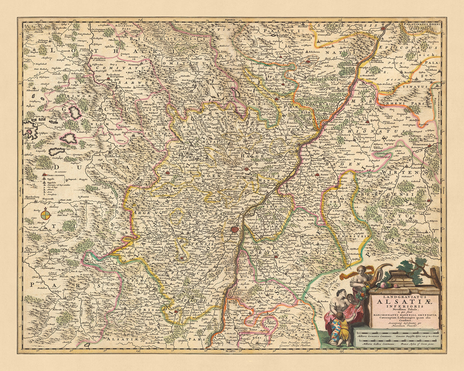


Old Map of Lower Alsace by Visscher, 1690: Strasbourg, Karlsruhe, Pforzheim, Speyer, North Vosges Reserve
Buy 2, Get 1 More Free
If you add 2 items to your bag, you can add a third product for free. The discount is automatic - no code required.
This is equivalent to 33% off, which will be the largest discount available on my shop this year.
This works for all maps and artwork. You can order 3 of the same thing, or 3 different things.
Custom maps are excluded, as they're too time consuming to make and we'd prefer to take our time rather than rush through a lot of orders.
Contact me if you have any questions.
- All taxes and duties included
- Handmade & dispatched in 1-2 days
-
Complimentary gifting & design advice
ⓘ
Complimentary gifting & design advice
Available almost 24/7 on WhatsApp and email — we usually reply within minutes. We can help you:
- Choose a perfectly personalised gift
- Send a digital gift preview to the recipient
- Pick the ideal size for your wall
- Select the right finish and frame
Quick, friendly advice so you can order with confidence.
For last minute gifts, consider buying a digital gift card. We have over 5,000 maps and art prints to choose from.
-
90-day returns & 5-year guarantee
ⓘ
90-day returns & 5-year guarantee
Products can be returned within 90 days for a full refund, or exchange for another product.
We are also proud to offer a 5-year quality guarantee on our maps and art, covering defects in materials or workmanship under normal use.
For personalised and custom made items, we may offer you store credit or a non-expiring gift card, as we cannot resell personalised orders.
If you have any questions, get in touch. For more information, see our full returns & exchanges policy.

This is a museum-grade archival print from the original 1690 map — restored in our workshop and made to order on 220gsm archival matte paper or 400gsm artist's cotton canvas with pigment inks.
Professional framing & free personalisation available
1. Choose a size
2. Frame & personalise your map
Make your map unique with framing, hand-drawn customisation, vintage ageing, pop art text, unique 3D styling and more.


Gift message & custom finish

If you want to add a gift message, or a finish (jigsaw, aluminium board, etc.) that is not available here, please request it in the "order note" when you check out.
Every order is custom made, so if you need the size adjusted slightly, or printed on an unusual material, just let us know. We've done thousands of custom orders over the years, so there's (almost) nothing we can't manage.
You can also contact us before you order, if you prefer!

- Handmade locally. No import duty or tax
- FREE worldwide delivery
- 90-day returns & 5-year product guarantee
- Questions? WhatsApp me any time
Own a piece of history
7,000+ 5 star reviews


Step back in time with this meticulously detailed map of Lower Alsace, crafted by the esteemed mapmaker Nicolaes Visscher II in 1690. Visscher, a prominent figure in the Dutch Golden Age of cartography, hails from a lineage of distinguished mapmakers, making this piece not just a map, but a piece of history.
This map, originally titled 'Landgraviatus Alsatiae Inferioris Novissima Tabula : in qua simul Marchionatus Badensis, Ortenavia, Caeteraquetam Lotharingica quam alia Confinia', translates to 'The Latest Map of the Lower County of Alsace: in which both the Margraviate of Baden, Ortenau, and the other Lorraine and other borders are shown'. This title reveals the vast expanse of territory covered by this map, which includes not only Lower Alsace, but also the Margraviate of Baden, Ortenau, and other bordering regions.
The map features several significant cities and landmarks, including Strasbourg, Karlsruhe, Pforzheim, Speyer, and the North Vosges Regional Natural Reserve. Strasbourg, the capital city of the Grand Est region of France, is known for its rich history and stunning Gothic architecture. Karlsruhe, located in the state of Baden-Württemberg, Germany, is home to one of the most important courts in Europe, the Federal Constitutional Court. Pforzheim, also in Baden-Württemberg, is known as the "Gateway to the Black Forest". Speyer, a town in Rhineland-Palatinate, Germany, is famous for its Romanesque cathedral, a UNESCO World Heritage Site. Lastly, the North Vosges Regional Natural Reserve, located in northeastern France, is known for its diverse flora and fauna.
In addition to these cities and landmarks, the map also provides a glimpse into the political divisions of the time. The Margraviate of Baden, Ortenau, and other regions are clearly delineated, providing insight into the geopolitical landscape of the late 17th century. This map is not only a testament to Visscher's cartographic skills, but also a fascinating snapshot of a time long past. Whether you're a history enthusiast, a map collector, or simply someone who appreciates fine artistry, this map of Lower Alsace by Nicolaes Visscher II is sure to captivate and inspire.
Some of the significant locations shown on this map:
Lower Alsace:
- Strasbourg: Known as Argentoratum in Roman times, it is the capital city of the Grand Est region of France. Famous for its rich history and stunning Gothic architecture.
- Haguenau: Founded in the 12th century, it was the residence of the Hohenstaufen emperors during the 12th and 13th centuries.
- Wissembourg: Known as Weissenburg in German, it was an important place in the Holy Roman Empire.
- Saverne: Known as Tres Tabernae in Roman times, it is famous for its beautiful landscapes and historic buildings.
- Sélestat: Known as Schlettstadt in German, it is home to the Humanist Library, one of the oldest public libraries in the world.
Margraviate of Baden:
- Karlsruhe: Founded in 1715, it is home to one of the most important courts in Europe, the Federal Constitutional Court.
- Baden-Baden: Known for its spa and casino, it was a popular destination for European nobility in the 18th century.
- Pforzheim: Known as the "Gateway to the Black Forest", it was a major center of jewelry and watchmaking in the 18th century.
- Rastatt: Home to the Baroque styled Rastatt Palace.
- Ettlingen: Known for its historic old town and the Ettlingen Palace.
Ortenau:
- Offenburg: Known for its vineyards and wine production.
- Kehl: Located on the Rhine river, it is the gateway to Strasbourg in France.
- Lahr: Known for its beautiful parks and gardens.
- Gengenbach: Famous for its traditional half-timbered houses.
- Haslach im Kinzigtal: Known for its historic old town.
Other Bordering Regions:
- Speyer: Known as Spira in Latin, it is famous for its Romanesque cathedral, a UNESCO World Heritage Site.
- Heidelberg: Known for Heidelberg University, the oldest university in Germany.
- Mannheim: Known for its grid-like downtown design, known as "Mannheimer Quadrate".
- Worms: Known for the Nibelungen saga and the Diet of Worms.
- Ludwigshafen: Known for being one of the most important chemical industry locations in the world.
In addition to these cities and towns, the map also includes several significant natural and geopolitical features:
- Rhine River: One of the longest and most important rivers in Europe, it forms a natural border between several countries.
- Black Forest: Known for its dense, evergreen forests and picturesque villages, it is a popular tourist destination.
- Vosges Mountains: Known for their rich variety of flora and fauna, they are home to the North Vosges Regional Natural Reserve.
- Palatinate Forest: The largest contiguous forest area in Germany, it is part of the UNESCO Palatinate Forest-North Vosges Biosphere Reserve.
- The border with Lorraine: This was a significant geopolitical boundary during the 17th century, marking the divide between French and German territories.
Notable historical events in this region between 1600 and 1690 include:
- The Thirty Years' War (1618-1648): This devastating conflict involved many of the cities and territories shown on the map.
- The Franco-Dutch War (1672-1678): This war led to the further expansion of French territory in the region.
- The founding of the University of Strasbourg in 1621: This marked a significant development in the intellectual and cultural life of the region.
Please double check the images to make sure that a specific town or place is shown on this map. You can also get in touch and ask us to check the map for you.
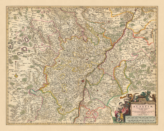
This map looks great at all sizes: 12x16in (30.5x41cm), 16x20in (40.5x51cm), 18x24in (45.5x61cm), 24x30in (61x76cm), 32x40in (81.5x102cm), 40x50in (102x127cm), 48x60in (122x153cm) and 56x70in (142x178cm), but it looks even better when printed large.
I can create beautiful, large prints of this map up to 90in (229cm). Please get in touch if you're looking for larger, customised or different framing options.
The model in the listing images is holding the 16x20in (40.5x51cm) version of this map.
The fifth listing image shows an example of my map personalisation service.
If you’re looking for something slightly different, check out my collection of the best old maps of Europe and European cities to see if something else catches your eye.
Please contact me to check if a certain location, landmark or feature is shown on this map.
This would make a wonderful birthday, Christmas, Father's Day, work leaving, anniversary or housewarming gift for someone from the areas covered by this map.
This map is available as a giclée print on acid free archival matte paper, or you can buy it framed. The frame is a nice, simple black frame that suits most aesthetics. Please get in touch if you'd like a different frame colour or material. My frames are glazed with super-clear museum-grade acrylic (perspex/acrylite), which is significantly less reflective than glass, safer, and will always arrive in perfect condition.
This map is also available as a float framed canvas, sometimes known as a shadow gap framed canvas or canvas floater. The map is printed on artist's cotton canvas and then stretched over a handmade box frame. We then "float" the canvas inside a wooden frame, which is available in a range of colours (black, dark brown, oak, antique gold and white). This is a wonderful way to present a map without glazing in front. See some examples of float framed canvas maps and explore the differences between my different finishes.
For something truly unique, this map is also available in "Unique 3D", our trademarked process that dramatically transforms the map so that it has a wonderful sense of depth. We combine the original map with detailed topography and elevation data, so that mountains and the terrain really "pop". For more info and examples of 3D maps, check my Unique 3D page.
For most orders, delivery time is about 3 working days. Personalised and customised products take longer, as I have to do the personalisation and send it to you for approval, which usually takes 1 or 2 days.
Please note that very large framed orders usually take longer to make and deliver.
If you need your order to arrive by a certain date, please contact me before you order so that we can find the best way of making sure you get your order in time.
I print and frame maps and artwork in 23 countries around the world. This means your order will be made locally, which cuts down on delivery time and ensures that it won't be damaged during delivery. You'll never pay customs or import duty, and we'll put less CO2 into the air.
All of my maps and art prints are well packaged and sent in a rugged tube if unframed, or surrounded by foam if framed.
I try to send out all orders within 1 or 2 days of receiving your order, though some products (like face masks, mugs and tote bags) can take longer to make.
If you select Express Delivery at checkout your order we will prioritise your order and send it out by 1-day courier (Fedex, DHL, UPS, Parcelforce).
Next Day delivery is also available in some countries (US, UK, Singapore, UAE) but please try to order early in the day so that we can get it sent out on time.
My standard frame is a gallery style black ash hardwood frame. It is simple and quite modern looking. My standard frame is around 20mm (0.8in) wide.
I use super-clear acrylic (perspex/acrylite) for the frame glass. It's lighter and safer than glass - and it looks better, as the reflectivity is lower.
Six standard frame colours are available for free (black, dark brown, dark grey, oak, white and antique gold). Custom framing and mounting/matting is available if you're looking for something else.
Most maps, art and illustrations are also available as a framed canvas. We use matte (not shiny) cotton canvas, stretch it over a sustainably sourced box wood frame, and then 'float' the piece within a wood frame. The end result is quite beautiful, and there's no glazing to get in the way.
All frames are provided "ready to hang", with either a string or brackets on the back. Very large frames will have heavy duty hanging plates and/or a mounting baton. If you have any questions, please get in touch.
See some examples of my framed maps and framed canvas maps.
Alternatively, I can also supply old maps and artwork on canvas, foam board, cotton rag and other materials.
If you want to frame your map or artwork yourself, please read my size guide first.
My maps are extremely high quality reproductions of original maps.
I source original, rare maps from libraries, auction houses and private collections around the world, restore them at my London workshop, and then use specialist giclée inks and printers to create beautiful maps that look even better than the original.
My maps are printed on acid-free archival matte (not glossy) paper that feels very high quality and almost like card. In technical terms the paper weight/thickness is 10mil/200gsm. It's perfect for framing.
I print with Epson ultrachrome giclée UV fade resistant pigment inks - some of the best inks you can find.
I can also make maps on canvas, cotton rag and other exotic materials.
Learn more about The Unique Maps Co.
Map personalisation
If you're looking for the perfect anniversary or housewarming gift, I can personalise your map to make it truly unique. For example, I can add a short message, or highlight an important location, or add your family's coat of arms.
The options are almost infinite. Please see my map personalisation page for some wonderful examples of what's possible.
To order a personalised map, select "personalise your map" before adding it to your basket.
Get in touch if you're looking for more complex customisations and personalisations.
Map ageing
I have been asked hundreds of times over the years by customers if they could buy a map that looks even older.
Well, now you can, by selecting Aged before you add a map to your basket.
All the product photos you see on this page show the map in its Original form. This is what the map looks like today.
If you select Aged, I will age your map by hand, using a special and unique process developed through years of studying old maps, talking to researchers to understand the chemistry of aging paper, and of course... lots of practice!
If you're unsure, stick to the Original colour of the map. If you want something a bit darker and older looking, go for Aged.
If you are not happy with your order for any reason, contact me and I'll get it fixed ASAP, free of charge. Please see my returns and refund policy for more information.
I am very confident you will like your restored map or art print. I have been doing this since 1984. I'm a 5-star Etsy seller. I have sold tens of thousands of maps and art prints and have over 5,000 real 5-star reviews. My work has been featured in interior design magazines, on the BBC, and on the walls of dozens of 5-star hotels.
I use a unique process to restore maps and artwork that is massively time consuming and labour intensive. Hunting down the original maps and illustrations can take months. I use state of the art and eye-wateringly expensive technology to scan and restore them. As a result, I guarantee my maps and art prints are a cut above the rest. I stand by my products and will always make sure you're 100% happy with what you receive.
Almost all of my maps and art prints look amazing at large sizes (200cm, 6.5ft+) and I can frame and deliver them to you as well, via special oversized courier. Contact me to discuss your specific needs.
Or try searching for something!


