

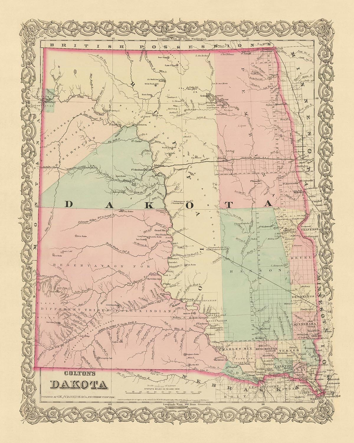

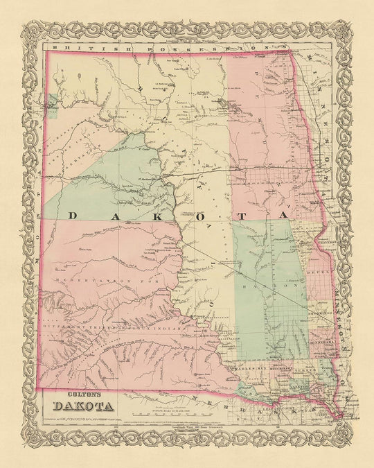


Old Map of North and South Dakota by J.H. Colton, 1873: Sioux Falls, Yankton, Vermillion, Brookings, and Watertown
- All taxes and duties included
- Handmade & dispatched in 1-2 days
-
FREE gift preview
ⓘ
Digital gift preview
New for 2025: After you complete your order, you can send a beautiful digital preview to the gift recipient. Just provide their email address and we'll do the rest. (Their email address will not be stored or used for any other purpose.)
This is perfect for Christmas gifting, particularly if you're concerned that your order might not arrive in time for Christmas.
-
90 day money back guarantee
ⓘ
90 days to return and refund
Products can be returned within 90 days for a full refund, or exchange for another product.
For personalised and custom made items, we may offer you store credit or a non-expiring gift card, as we cannot resell personalised orders.
If you have any questions, get in touch. For more information, see our full returns & exchanges policy.

My maps are rare, museum-grade, restored old maps sourced from libraries, auction houses and private collections across the globe.
Framing & free personalisation available
1. Select your size
2. Frame & personalise your map
There is limited framing & personalisation capacity available. Order by 10am tomorrow for Christmas delivery.


Gift message & custom finish

If you want to add a gift message, or a finish (jigsaw, aluminium board, etc.) that is not available here, please request it in the "order note" when you check out.
Every order is custom made, so if you need the size adjusted slightly, or printed on an unusual material, just let us know. We've done thousands of custom orders over the years, so there's (almost) nothing we can't manage.
You can also contact us before you order, if you prefer!

- Handmade locally. No import duty or tax
- FREE Delivery by Christmas
- Love it or your money back (90 days)
- Questions? WhatsApp me any time
Own a piece of history
5,000+ 5 star reviews


Immerse yourself in the early history of the United States with this exquisite map of Dakota from 1873, meticulously crafted by the esteemed mapmaker J.H. Colton. This map provides a fascinating snapshot of the region, at a time when many of its settlements were in their infancy, and the landscape was largely uncharted. As one of the most respected American mapmakers of his era, Colton's work offers unparalleled accuracy and attention to detail, making this a truly unique piece of historical cartography.
This map of Dakota, which today comprises both North and South Dakota, captures a period of great change and development in the United States. At this time, many settlements had not yet been founded, and the names and borders that we are familiar with today were still in flux. The map features the five most notable settlements of the era - Sioux Falls, Yankton, Vermillion, Brookings, and Watertown. Each of these settlements played a significant role in the shaping of the region, and their depiction on this map provides a fascinating insight into the early history of Dakota.
In the 150 years since this map was created, many changes have occurred in the region. The borders have shifted, new towns and cities have emerged, and old ones have disappeared or been renamed. Yet, despite these changes, this map remains a valuable record of the past. It allows us to trace the evolution of the region and to gain a deeper understanding of the historical context in which these changes took place. This is a rare opportunity to own a piece of American history, beautifully preserved in the form of a map.
Whether you're a history enthusiast, a cartography lover, or simply someone who appreciates the beauty of old maps, this piece is sure to be a cherished addition to your collection.
Experience the rich history of Dakota as it was in 1873, through the lens of one of America's finest mapmakers. This map is not just a piece of history, but a work of art that tells a story of a time and place that has shaped the world as we know it today. Don't miss the chance to own this remarkable piece of cartographic history.
North Dakota
- Pembina (1812): Known as the "Gateway to the Dakotas," Pembina was the first European settlement in North Dakota. It was a fur trading post before becoming a town.
- Fort Union Trading Post (1828): This was the most important fur trading post on the upper Missouri until 1867. Today, it's a National Historic Site.
- Fort Abercrombie (1858): Known as "The Gateway to the Dakotas," it was the first permanent U.S. military fort in what is now North Dakota.
- Bismarck (1872): Originally named Edwinton, it was renamed Bismarck in honor of the German chancellor to attract German investment in the Northern Pacific Railroad.
- Fargo (1871): Known as "The Gateway to the West," Fargo was a stopping point for steamboats traversing the Red River during the 1870s and 1880s.
South Dakota
- Fort Pierre (1817): Originally a trading post, it was the site of the first European settlement in South Dakota.
- Yankton (1859): Known as the "Mother City of the Dakotas," Yankton was the first capital of Dakota Territory.
- Sioux Falls (1856): Named for the Sioux tribe and the waterfalls in the Big Sioux River, it was an important center for agate trade.
- Vermillion (1859): Home to the University of South Dakota, the oldest university in the state.
- Brookings (1871): Named after one of South Dakota's pioneer promoters, Wilmot Brookings, and home to South Dakota State University.
Indian Tribes
- Sioux Tribe: One of the largest tribes in the Dakota region, known for their hunting and warrior culture.
- Mandan Tribe: Known for their permanent agricultural settlements along the Missouri River.
- Hidatsa Tribe: Originally lived in earth lodges in the Missouri River area, they were known for their farming and trading.
- Arikara Tribe: Also known as the Ree, they were semi-nomadic and known for their fortified villages.
Notable Natural Features
- Missouri River: The longest river in North America, it played a crucial role in the westward expansion of the United States.
- Badlands National Park: Known for its dramatic landscapes, it's home to one of the world's richest fossil beds.
- Black Hills: A small, isolated mountain range rising from the Great Plains, it's known for its granite peaks and forested hills.
Historical Events
- Establishment of Dakota Territory (1861): The Dakota Territory was created by an act of Congress and signed into law by President James Buchanan.
- Dakota War of 1862: Also known as the Sioux Uprising, it was an armed conflict between the United States and several bands of Dakota (Sioux).
- Yankton Treaty (1858): This treaty ceded much of present-day eastern South Dakota to the United States.
Please double check the images to make sure that a specific town or place is shown on this map. You can also get in touch and ask us to check the map for you.
This map looks great at all sizes: 12x16in (30.5x41cm), 16x20in (40.5x51cm), 18x24in (45.5x61cm), 24x30in (61x76cm), 32x40in (81.5x102cm), 40x50in (102x127cm), 48x60in (122x153cm) and 56x70in (142x178cm), but it looks even better when printed large.
I can create beautiful, large prints of this map up to 70in (178cm). Please get in touch if you're looking for larger, customised or different framing options.
The model in the listing images is holding the 16x20in (40.5x51cm) version of this map.
The fifth listing image shows an example of my map personalisation service.
If you’re looking for something slightly different, check out my main collection of USA and North America maps.
Please contact me to check if a certain location, landmark or feature is shown on this map.
This would make a wonderful birthday, Christmas, Father's Day, work leaving, anniversary or housewarming gift for someone from the areas covered by this map.
This map is available as a giclée print on acid free archival matte paper, or you can buy it framed. The frame is a nice, simple black frame that suits most aesthetics. Please get in touch if you'd like a different frame colour or material. My frames are glazed with super-clear museum-grade acrylic (perspex/acrylite), which is significantly less reflective than glass, safer, and will always arrive in perfect condition.
This map is also available as a float framed canvas, sometimes known as a shadow gap framed canvas or canvas floater. The map is printed on artist's cotton canvas and then stretched over a handmade box frame. We then "float" the canvas inside a wooden frame, which is available in a range of colours (black, dark brown, oak, antique gold and white). This is a wonderful way to present a map without glazing in front. See some examples of float framed canvas maps and explore the differences between my different finishes.
For something truly unique, this map is also available in "Unique 3D", our trademarked process that dramatically transforms the map so that it has a wonderful sense of depth. We combine the original map with detailed topography and elevation data, so that mountains and the terrain really "pop". For more info and examples of 3D maps, check my Unique 3D page.
For most orders, delivery time is about 3 working days. Personalised and customised products take longer, as I have to do the personalisation and send it to you for approval, which usually takes 1 or 2 days.
Please note that very large framed orders usually take longer to make and deliver.
If you need your order to arrive by a certain date, please contact me before you order so that we can find the best way of making sure you get your order in time.
I print and frame maps and artwork in 23 countries around the world. This means your order will be made locally, which cuts down on delivery time and ensures that it won't be damaged during delivery. You'll never pay customs or import duty, and we'll put less CO2 into the air.
All of my maps and art prints are well packaged and sent in a rugged tube if unframed, or surrounded by foam if framed.
I try to send out all orders within 1 or 2 days of receiving your order, though some products (like face masks, mugs and tote bags) can take longer to make.
If you select Express Delivery at checkout your order we will prioritise your order and send it out by 1-day courier (Fedex, DHL, UPS, Parcelforce).
Next Day delivery is also available in some countries (US, UK, Singapore, UAE) but please try to order early in the day so that we can get it sent out on time.
My standard frame is a gallery style black ash hardwood frame. It is simple and quite modern looking. My standard frame is around 20mm (0.8in) wide.
I use super-clear acrylic (perspex/acrylite) for the frame glass. It's lighter and safer than glass - and it looks better, as the reflectivity is lower.
Six standard frame colours are available for free (black, dark brown, dark grey, oak, white and antique gold). Custom framing and mounting/matting is available if you're looking for something else.
Most maps, art and illustrations are also available as a framed canvas. We use matte (not shiny) cotton canvas, stretch it over a sustainably sourced box wood frame, and then 'float' the piece within a wood frame. The end result is quite beautiful, and there's no glazing to get in the way.
All frames are provided "ready to hang", with either a string or brackets on the back. Very large frames will have heavy duty hanging plates and/or a mounting baton. If you have any questions, please get in touch.
See some examples of my framed maps and framed canvas maps.
Alternatively, I can also supply old maps and artwork on canvas, foam board, cotton rag and other materials.
If you want to frame your map or artwork yourself, please read my size guide first.
My maps are extremely high quality reproductions of original maps.
I source original, rare maps from libraries, auction houses and private collections around the world, restore them at my London workshop, and then use specialist giclée inks and printers to create beautiful maps that look even better than the original.
My maps are printed on acid-free archival matte (not glossy) paper that feels very high quality and almost like card. In technical terms the paper weight/thickness is 10mil/200gsm. It's perfect for framing.
I print with Epson ultrachrome giclée UV fade resistant pigment inks - some of the best inks you can find.
I can also make maps on canvas, cotton rag and other exotic materials.
Learn more about The Unique Maps Co.
Map personalisation
If you're looking for the perfect anniversary or housewarming gift, I can personalise your map to make it truly unique. For example, I can add a short message, or highlight an important location, or add your family's coat of arms.
The options are almost infinite. Please see my map personalisation page for some wonderful examples of what's possible.
To order a personalised map, select "personalise your map" before adding it to your basket.
Get in touch if you're looking for more complex customisations and personalisations.
Map ageing
I have been asked hundreds of times over the years by customers if they could buy a map that looks even older.
Well, now you can, by selecting Aged before you add a map to your basket.
All the product photos you see on this page show the map in its Original form. This is what the map looks like today.
If you select Aged, I will age your map by hand, using a special and unique process developed through years of studying old maps, talking to researchers to understand the chemistry of aging paper, and of course... lots of practice!
If you're unsure, stick to the Original colour of the map. If you want something a bit darker and older looking, go for Aged.
If you are not happy with your order for any reason, contact me and I'll get it fixed ASAP, free of charge. Please see my returns and refund policy for more information.
I am very confident you will like your restored map or art print. I have been doing this since 1984. I'm a 5-star Etsy seller. I have sold tens of thousands of maps and art prints and have over 5,000 real 5-star reviews. My work has been featured in interior design magazines, on the BBC, and on the walls of dozens of 5-star hotels.
I use a unique process to restore maps and artwork that is massively time consuming and labour intensive. Hunting down the original maps and illustrations can take months. I use state of the art and eye-wateringly expensive technology to scan and restore them. As a result, I guarantee my maps and art prints are a cut above the rest. I stand by my products and will always make sure you're 100% happy with what you receive.
Almost all of my maps and art prints look amazing at large sizes (200cm, 6.5ft+) and I can frame and deliver them to you as well, via special oversized courier. Contact me to discuss your specific needs.
Or try searching for something!


