

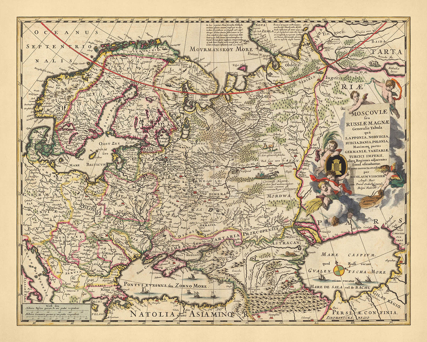
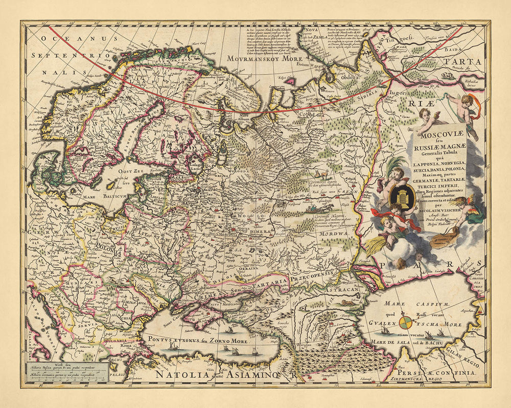


Old Map of Russia by Visscher, 1690: Moscow, Warsaw, Budapest, Oslo, Stockholm
- All taxes and duties included
- Handmade & dispatched in 1-2 days
-
FREE gift preview
ⓘ
Digital gift preview
New for 2025: After you complete your order, you can send a beautiful digital preview to the gift recipient. Just provide their email address and we'll do the rest. (Their email address will not be stored or used for any other purpose.)
This is perfect for Christmas gifting, particularly if you're concerned that your order might not arrive in time for Christmas.
-
90 day money back guarantee
ⓘ
90 days to return and refund
Products can be returned within 90 days for a full refund, or exchange for another product.
For personalised and custom made items, we may offer you store credit or a non-expiring gift card, as we cannot resell personalised orders.
If you have any questions, get in touch. For more information, see our full returns & exchanges policy.

My maps are rare, museum-grade, restored old maps sourced from libraries, auction houses and private collections across the globe.
Framing & free personalisation available
1. Select your size
2. Frame & personalise your map
There is limited framing & personalisation capacity available. Order by 10am tomorrow for Christmas delivery.


Gift message & custom finish

If you want to add a gift message, or a finish (jigsaw, aluminium board, etc.) that is not available here, please request it in the "order note" when you check out.
Every order is custom made, so if you need the size adjusted slightly, or printed on an unusual material, just let us know. We've done thousands of custom orders over the years, so there's (almost) nothing we can't manage.
You can also contact us before you order, if you prefer!

- Handmade locally. No import duty or tax
- FREE Delivery by Christmas
- Love it or your money back (90 days)
- Questions? WhatsApp me any time
Own a piece of history
5,000+ 5 star reviews


Immerse yourself in the rich history of Russia with this intricate map, masterfully crafted by Nicolaes Visscher II in 1690. The map, formally titled 'Moscoviae seu Russiae Magnae Generalis Tabula', translates to 'General Map of Moscow or Greater Russia', and it provides an in-depth look at the political divisions and geographical intricacies of Russia and its surrounding regions during the era of the Tsardom of Russia. The map captures regions such as Lapland, Norway, Sweden, Denmark, Poland, most parts of Germany, Tartary, the Turkish Empire, and other adjacent regions.
The map features several major cities of the era, offering a unique historical perspective on their early development. Moscow, the capital of Russia, is prominently displayed, reflecting its status as a political, economic, and cultural hub. Warsaw, the future capital of Poland, is also depicted, offering a glimpse into its rich history. Budapest, a city renowned for its architectural beauty, is also included, along with Oslo and Stockholm, significant cities in Scandinavia.
Visscher's map also provides insight into the natural landscapes and geographical features of the region. It showcases the vastness of the Russian terrain, from the Ural Mountains that serve as a natural border between Europe and Asia, to the Volga River, Europe's longest river, flowing through central Russia. The map also hints at the Arctic tundra of Lapland and the expansive plains of Tartary, parts of modern-day Central Asia.
This map by Nicolaes Visscher II is more than just a geographical representation; it is a historical document that narrates the story of Russia and its surrounding regions in the late 17th century. It provides a fascinating look into the political divisions, major cities, and natural landscapes of the time. This map allows you to explore Russia and its neighboring regions as they were over three centuries ago, making it a valuable addition to any collection.
Some of the significant locations shown on this map:
Russia
- Moscow - Known as Moskva in Russian, it is the capital city and the most populous city in Russia. It has been the political, economic, and cultural center of Russia for centuries.
- Novgorod - One of the oldest and most important historic cities in Russia, it was a key link between western and eastern parts of the country.
- Kazan - Known as the third capital of Russia, it is the most populous city in the republic of Tatarstan.
- Yaroslavl - A significant cultural and economic center in Russia, it is one of the oldest Russian cities, founded in the 11th century.
- Rostov - Not to be confused with Rostov-on-Don, it is one of the oldest towns in Russia and a major tourist center.
Poland
- Warsaw - The capital and largest city of Poland, it was known as Warszawa in Polish.
- Krakow - A historic city, it was the capital of Poland until 1596.
- Poznan - One of the oldest cities in Poland, it was known as Posnania during the Middle Ages.
- Gdansk - Known as Danzig in German, it is a major seaport and industrial city in Poland.
- Lublin - A major cultural, academic, and economic hub, it is the ninth-largest city in Poland.
Hungary
- Budapest - The capital and most populous city of Hungary, it was formed by the unification of Buda, Pest, and Óbuda in 1873.
- Debrecen - The second-largest city in Hungary, it was the largest Hungarian city in the 18th century.
- Szeged - Known as the "City of Sunshine", it is the third-largest city in Hungary.
- Pecs - Known for its rich history and culture, it is the fifth-largest city in Hungary.
- Gyor - Known as the most important city of northwest Hungary, it is the sixth-largest city in the country.
Norway
- Oslo - The capital and most populous city of Norway, it was known as Christiania from 1624 to 1925.
- Bergen - Known as Bjørgvin in Old Norse, it is the second-largest city in Norway.
- Trondheim - Known as Nidaros during the Middle Ages, it is the third-largest city in Norway.
- Stavanger - Known for its well-preserved old town, it is the fourth-largest city in Norway.
- Drammen - A significant river port, it is the sixth-largest urban area of Norway.
Sweden
- Stockholm - The capital and most populous city of Sweden, it is known for its beauty, buildings, and abundant clean and open water.
- Gothenburg - Known as Göteborg in Swedish, it is the second-largest city in Sweden.
- Malmo - Known for its rich history and culture, it is the third-largest city in Sweden.
- Uppsala - Known as a cultural and religious center, it is the fourth-largest city in Sweden.
- Vasteras - Known for its industry, it is the sixth-largest city in Sweden.
Notable Natural Phenomena
- The Ural Mountains - A natural boundary between Europe and Asia.
- The Volga River - The longest river in Europe.
- The Arctic Circle - A major line of latitude, significant for its extreme conditions.
- The Baltic Sea - A major body of water, known for its unique brackish water.
- The Black Sea - Known for its rich history and biodiversity.
Notable Historical Events (1600-1690)
- The Time of Troubles (1598-1613) - A period of political crisis in Russia, marked by the Polish-Muscovite War (1605-1618).
- The Thirty Years' War (1618-1648) - A major conflict that involved many European powers, it significantly affected Poland.
- The Russo-Polish War (1654-1667) - A major conflict between the Tsardom of Russia and the Polish-Lithuanian Commonwealth.
Please double check the images to make sure that a specific town or place is shown on this map. You can also get in touch and ask us to check the map for you.
This map looks great at all sizes: 12x16in (30.5x41cm), 16x20in (40.5x51cm), 18x24in (45.5x61cm), 24x30in (61x76cm), 32x40in (81.5x102cm), 40x50in (102x127cm), 48x60in (122x153cm) and 56x70in (142x178cm), but it looks even better when printed large.
I can create beautiful, large prints of this map up to 90in (229cm). Please get in touch if you're looking for larger, customised or different framing options.
The model in the listing images is holding the 16x20in (40.5x51cm) version of this map.
The fifth listing image shows an example of my map personalisation service.
If you’re looking for something slightly different, check out my collection of the best old maps of Europe and European cities to see if something else catches your eye.
Please contact me to check if a certain location, landmark or feature is shown on this map.
This would make a wonderful birthday, Christmas, Father's Day, work leaving, anniversary or housewarming gift for someone from the areas covered by this map.
This map is available as a giclée print on acid free archival matte paper, or you can buy it framed. The frame is a nice, simple black frame that suits most aesthetics. Please get in touch if you'd like a different frame colour or material. My frames are glazed with super-clear museum-grade acrylic (perspex/acrylite), which is significantly less reflective than glass, safer, and will always arrive in perfect condition.
This map is also available as a float framed canvas, sometimes known as a shadow gap framed canvas or canvas floater. The map is printed on artist's cotton canvas and then stretched over a handmade box frame. We then "float" the canvas inside a wooden frame, which is available in a range of colours (black, dark brown, oak, antique gold and white). This is a wonderful way to present a map without glazing in front. See some examples of float framed canvas maps and explore the differences between my different finishes.
For something truly unique, this map is also available in "Unique 3D", our trademarked process that dramatically transforms the map so that it has a wonderful sense of depth. We combine the original map with detailed topography and elevation data, so that mountains and the terrain really "pop". For more info and examples of 3D maps, check my Unique 3D page.
For most orders, delivery time is about 3 working days. Personalised and customised products take longer, as I have to do the personalisation and send it to you for approval, which usually takes 1 or 2 days.
Please note that very large framed orders usually take longer to make and deliver.
If you need your order to arrive by a certain date, please contact me before you order so that we can find the best way of making sure you get your order in time.
I print and frame maps and artwork in 23 countries around the world. This means your order will be made locally, which cuts down on delivery time and ensures that it won't be damaged during delivery. You'll never pay customs or import duty, and we'll put less CO2 into the air.
All of my maps and art prints are well packaged and sent in a rugged tube if unframed, or surrounded by foam if framed.
I try to send out all orders within 1 or 2 days of receiving your order, though some products (like face masks, mugs and tote bags) can take longer to make.
If you select Express Delivery at checkout your order we will prioritise your order and send it out by 1-day courier (Fedex, DHL, UPS, Parcelforce).
Next Day delivery is also available in some countries (US, UK, Singapore, UAE) but please try to order early in the day so that we can get it sent out on time.
My standard frame is a gallery style black ash hardwood frame. It is simple and quite modern looking. My standard frame is around 20mm (0.8in) wide.
I use super-clear acrylic (perspex/acrylite) for the frame glass. It's lighter and safer than glass - and it looks better, as the reflectivity is lower.
Six standard frame colours are available for free (black, dark brown, dark grey, oak, white and antique gold). Custom framing and mounting/matting is available if you're looking for something else.
Most maps, art and illustrations are also available as a framed canvas. We use matte (not shiny) cotton canvas, stretch it over a sustainably sourced box wood frame, and then 'float' the piece within a wood frame. The end result is quite beautiful, and there's no glazing to get in the way.
All frames are provided "ready to hang", with either a string or brackets on the back. Very large frames will have heavy duty hanging plates and/or a mounting baton. If you have any questions, please get in touch.
See some examples of my framed maps and framed canvas maps.
Alternatively, I can also supply old maps and artwork on canvas, foam board, cotton rag and other materials.
If you want to frame your map or artwork yourself, please read my size guide first.
My maps are extremely high quality reproductions of original maps.
I source original, rare maps from libraries, auction houses and private collections around the world, restore them at my London workshop, and then use specialist giclée inks and printers to create beautiful maps that look even better than the original.
My maps are printed on acid-free archival matte (not glossy) paper that feels very high quality and almost like card. In technical terms the paper weight/thickness is 10mil/200gsm. It's perfect for framing.
I print with Epson ultrachrome giclée UV fade resistant pigment inks - some of the best inks you can find.
I can also make maps on canvas, cotton rag and other exotic materials.
Learn more about The Unique Maps Co.
Map personalisation
If you're looking for the perfect anniversary or housewarming gift, I can personalise your map to make it truly unique. For example, I can add a short message, or highlight an important location, or add your family's coat of arms.
The options are almost infinite. Please see my map personalisation page for some wonderful examples of what's possible.
To order a personalised map, select "personalise your map" before adding it to your basket.
Get in touch if you're looking for more complex customisations and personalisations.
Map ageing
I have been asked hundreds of times over the years by customers if they could buy a map that looks even older.
Well, now you can, by selecting Aged before you add a map to your basket.
All the product photos you see on this page show the map in its Original form. This is what the map looks like today.
If you select Aged, I will age your map by hand, using a special and unique process developed through years of studying old maps, talking to researchers to understand the chemistry of aging paper, and of course... lots of practice!
If you're unsure, stick to the Original colour of the map. If you want something a bit darker and older looking, go for Aged.
If you are not happy with your order for any reason, contact me and I'll get it fixed ASAP, free of charge. Please see my returns and refund policy for more information.
I am very confident you will like your restored map or art print. I have been doing this since 1984. I'm a 5-star Etsy seller. I have sold tens of thousands of maps and art prints and have over 5,000 real 5-star reviews. My work has been featured in interior design magazines, on the BBC, and on the walls of dozens of 5-star hotels.
I use a unique process to restore maps and artwork that is massively time consuming and labour intensive. Hunting down the original maps and illustrations can take months. I use state of the art and eye-wateringly expensive technology to scan and restore them. As a result, I guarantee my maps and art prints are a cut above the rest. I stand by my products and will always make sure you're 100% happy with what you receive.
Almost all of my maps and art prints look amazing at large sizes (200cm, 6.5ft+) and I can frame and deliver them to you as well, via special oversized courier. Contact me to discuss your specific needs.
Or try searching for something!


