


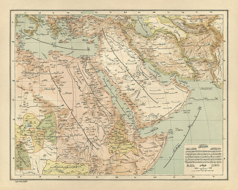
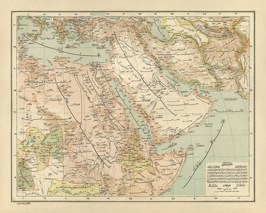


Old Arabic Map of the Middle East by Esref, 1893: Ottoman Empire, Jerusalem, Mecca, Arabian Peninsula
Buy 2, Get 1 More Free
If you add 2 items to your bag, you can add a third product for free. The discount is automatic - no code required.
This is equivalent to 33% off, which will be the largest discount available on my shop this year.
This works for all maps and artwork. You can order 3 of the same thing, or 3 different things.
Custom maps are excluded, as they're too time consuming to make and we'd prefer to take our time rather than rush through a lot of orders.
Contact me if you have any questions.
- All taxes and duties included
- Handmade & dispatched in 1-2 days
-
Complimentary gifting & design advice
ⓘ
Complimentary gifting & design advice
Available almost 24/7 on WhatsApp and email — we usually reply within minutes. We can help you:
- Choose a perfectly personalised gift
- Send a digital gift preview to the recipient
- Pick the ideal size for your wall
- Select the right finish and frame
Quick, friendly advice so you can order with confidence.
For last minute gifts, consider buying a digital gift card. We have over 5,000 maps and art prints to choose from.
-
90-day returns & 5-year guarantee
ⓘ
90-day returns & 5-year guarantee
Products can be returned within 90 days for a full refund, or exchange for another product.
We are also proud to offer a 5-year quality guarantee on our maps and art, covering defects in materials or workmanship under normal use.
For personalised and custom made items, we may offer you store credit or a non-expiring gift card, as we cannot resell personalised orders.
If you have any questions, get in touch. For more information, see our full returns & exchanges policy.

This is a museum-grade archival print from the original 1893 map — restored in our workshop and made to order on 220gsm archival matte paper or 400gsm artist's cotton canvas with pigment inks.
Professional framing & free personalisation available
1. Choose a size
2. Frame & personalise your map
Make your map unique with framing, hand-drawn customisation, vintage ageing, pop art text, unique 3D styling and more.


Gift message & custom finish

If you want to add a gift message, or a finish (jigsaw, aluminium board, etc.) that is not available here, please request it in the "order note" when you check out.
Every order is custom made, so if you need the size adjusted slightly, or printed on an unusual material, just let us know. We've done thousands of custom orders over the years, so there's (almost) nothing we can't manage.
You can also contact us before you order, if you prefer!

- Handmade locally. No import duty or tax
- FREE worldwide delivery
- 90-day returns & 5-year product guarantee
- Questions? WhatsApp me any time
Own a piece of history
7,000+ 5 star reviews


Embark on a historical journey with the exquisite "Ottoman Empire and Surrounding Regions" map, a masterpiece crafted by the renowned Turkish cartographer Hafiz Ali Esref in 1893. This map is not merely a navigational tool but a window into the past, offering a glimpse into the vast expanse of the Ottoman Empire at the zenith of its power. Hafiz Ali Esref, a luminary in the field of cartography and geography, utilized his profound knowledge and skills to create a map that is both a work of art and a valuable historical document. His meticulous attention to detail and dedication to accuracy have rendered this map an indispensable resource for historians and enthusiasts alike, capturing the essence of an era when the Ottoman Empire was a pivotal player on the global stage.
The map itself is a testament to the complexity and diversity of the Ottoman Empire, detailing not only the political borders and provinces but also the rich tapestry of physical landscapes that defined the region. From the rugged Taurus and Zagros mountains to the serene waters of the Mediterranean and Red Seas, each feature is delineated with precision. This detailed political and physical map goes beyond mere geography, chronicling the major cities, towns, and the lifelines of trade that connected them. Cities like Baghdad, Damascus, and Jerusalem are marked, their historical significance underscored by their prominence on the map. The inclusion of trade routes further illuminates the economic vitality of the Ottoman Empire, showcasing its role as a bridge between East and West.
In a script that evokes the elegance and complexity of the era, the map is inscribed in Ottoman Turkish, with place names rendered in both Arabic and Ottoman Turkish scripts. This linguistic choice not only adds to the map's authenticity but also reflects the cultural and administrative intricacies of the Ottoman Empire. It is a nod to the empire's rich heritage, a melting pot of languages, religions, and cultures that thrived under Ottoman rule. The dual script serves as a reminder of the empire's vast reach and its ability to encompass a multitude of identities within its borders.
The "Ottoman Empire and Surrounding Regions" map is not just a geographical representation; it is a historical artifact that captures the geopolitical landscape of the late 19th century. It delineates the borders of neighboring entities such as Egypt, the Hejaz, and various parts of the Arabian Peninsula, offering insights into the complex relationships and territorial disputes of the time. The map also extends to include significant portions of Africa and Asia, highlighting the Ottoman Empire's extensive influence and interactions with neighboring regions. This comprehensive coverage makes the map a valuable resource for understanding the dynamics of power, trade, and diplomacy in a pivotal period of history.
As part of a larger collection held in the Turkish National Library, this map by Hafiz Ali Esref stands as a monument to the cartographic excellence and historical significance of the Ottoman Empire. It offers scholars, collectors, and history enthusiasts an unparalleled opportunity to explore the empire's legacy from a unique vantage point. Whether as a focal point in a distinguished collection or as a tool for academic research, this map is a treasure trove of information, inviting viewers to delve into the intricacies of a bygone era and discover the stories etched in its landscapes and borders.
Cities and towns on this map
- Iraq:
- Baghdad (5,393,440)
- Mosul (1,749,000)
- Basra (1,470,000)
- Najaf (1,000,000)
- Karbala (700,000)
- Kirkuk (500,000)
- Sulaymaniyah (400,000)
- Erbil (350,000)
- Tikrit (250,000)
- Ramadi, Fallujah, Amara, Kut, Diwaniyah, Hillah, Nasiriyah, Baqubah, Zakho, Dohuk, Sinjar, Haditha, Al-Qaim, Rutba, Al-Ubayyid, Al-Diwaniyah, Al-Kut, Al-Hillah, An-Nasiriyah, Khanaqin, Mandali, Jassan, Afak, Altin Kopru, Tuz Khurmatu, Chamchamal, Penjwen, Rania, Aqrah, Amadiyah, Umm Qasr, Safwan, Az Zubayr, Al Faw, Al Basrah al Qadimah (All with populations around 100,000-200,000)
- Iran:
- Tehran (8,693,706)
- Mashhad (3,001,184)
- Isfahan (2,068,383)
- Karaj (1,592,492)
- Tabriz (1,585,941)
- Shiraz (1,565,572)
- Qom (1,201,158)
- Ahvaz (1,184,788)
- Kermanshah (946,681)
- Urmia (736,224)
- Yazd, Rasht, Zanjan, Hamadan, Sanandaj, Kerman, Bukan, Qazvin, Dezful, Arak, Eslamshahr, Malayer, Maragheh (Populations ranging from 349,842 to 529,983)
Notable Features & Landmarks
- Borders:
- Ottoman Empire
- Egypt
- Anglo-Egyptian Sudan
- Eritrea
- Abyssinia
- Italian Somaliland
- British Somaliland
- Aden
- Hejaz
- Nejd
- Al-Hasa
- Kuwait
- Iraq
- Syria
- Palestine
- Transjordan
- Lebanon
- Cyprus
- Bodies of water:
- Mediterranean Sea
- Red Sea
- Persian Gulf
- Arabian Sea
- Caspian Sea
- Lake Van
- Lake Urmia
- Dead Sea
- Mountains:
- Taurus Mountains
- Anti-Taurus Mountains
- Zagros Mountains
- Elburz Mountains
- Sinai Peninsula
- Other:
- Mecca
- Medina
- Jerusalem
- Damascus
- Baghdad
- Mosul
- Basra
- Kuwait City
- Riyadh
- Jeddah
- Aden
- Berbera
- Zeila
- Massawa
- Asmara
- Addis Ababa
- Mogadishu
- Hargeisa
- Socotra
Historical and design context
- The map is titled "Ottoman Empire and Surrounding Regions."
- Created by Hafiz Ali Esref in 1893, a Turkish cartographer and geographer renowned for his detailed maps of the Ottoman Empire.
- It is a political and physical map, showing the borders of the Ottoman Empire and its provinces, as well as major physical features like mountains, rivers, and deserts.
- The map also details the locations of major cities and towns, along with the routes of major trade routes.
- Written in Ottoman Turkish, with place names in both Arabic and Ottoman Turkish script, highlighting the linguistic diversity of the empire.
- Provides a detailed snapshot of the Ottoman Empire at the end of the 19th century, making it a valuable historical document.
- Part of a larger collection of maps created by Hafiz Ali Esref, now held in the Turkish National Library.
Please double check the images to make sure that a specific town or place is shown on this map. You can also get in touch and ask us to check the map for you.
This map looks great at every size, but I always recommend going for a larger size if you have space. That way you can easily make out all of the details.
This map looks amazing at sizes all the way up to 70in (180cm). If you are looking for a larger map, please get in touch.
The model in the listing images is holding the 16x20in (40x50cm) version of this map.
The fifth listing image shows an example of my map personalisation service.
If you’re looking for something slightly different, check out my collection of the best old maps to see if something else catches your eye.
Please contact me to check if a certain location, landmark or feature is shown on this map.
This would make a wonderful birthday, Christmas, Father's Day, work leaving, anniversary or housewarming gift for someone from the areas covered by this map.
This map is available as a giclée print on acid free archival matte paper, or you can buy it framed. The frame is a nice, simple black frame that suits most aesthetics. Please get in touch if you'd like a different frame colour or material. My frames are glazed with super-clear museum-grade acrylic (perspex/acrylite), which is significantly less reflective than glass, safer, and will always arrive in perfect condition.
This map is also available as a float framed canvas, sometimes known as a shadow gap framed canvas or canvas floater. The map is printed on artist's cotton canvas and then stretched over a handmade box frame. We then "float" the canvas inside a wooden frame, which is available in a range of colours (black, dark brown, oak, antique gold and white). This is a wonderful way to present a map without glazing in front. See some examples of float framed canvas maps and explore the differences between my different finishes.
For something truly unique, this map is also available in "Unique 3D", our trademarked process that dramatically transforms the map so that it has a wonderful sense of depth. We combine the original map with detailed topography and elevation data, so that mountains and the terrain really "pop". For more info and examples of 3D maps, check my Unique 3D page.
For most orders, delivery time is about 3 working days. Personalised and customised products take longer, as I have to do the personalisation and send it to you for approval, which usually takes 1 or 2 days.
Please note that very large framed orders usually take longer to make and deliver.
If you need your order to arrive by a certain date, please contact me before you order so that we can find the best way of making sure you get your order in time.
I print and frame maps and artwork in 23 countries around the world. This means your order will be made locally, which cuts down on delivery time and ensures that it won't be damaged during delivery. You'll never pay customs or import duty, and we'll put less CO2 into the air.
All of my maps and art prints are well packaged and sent in a rugged tube if unframed, or surrounded by foam if framed.
I try to send out all orders within 1 or 2 days of receiving your order, though some products (like face masks, mugs and tote bags) can take longer to make.
If you select Express Delivery at checkout your order we will prioritise your order and send it out by 1-day courier (Fedex, DHL, UPS, Parcelforce).
Next Day delivery is also available in some countries (US, UK, Singapore, UAE) but please try to order early in the day so that we can get it sent out on time.
My standard frame is a gallery style black ash hardwood frame. It is simple and quite modern looking. My standard frame is around 20mm (0.8in) wide.
I use super-clear acrylic (perspex/acrylite) for the frame glass. It's lighter and safer than glass - and it looks better, as the reflectivity is lower.
Six standard frame colours are available for free (black, dark brown, dark grey, oak, white and antique gold). Custom framing and mounting/matting is available if you're looking for something else.
Most maps, art and illustrations are also available as a framed canvas. We use matte (not shiny) cotton canvas, stretch it over a sustainably sourced box wood frame, and then 'float' the piece within a wood frame. The end result is quite beautiful, and there's no glazing to get in the way.
All frames are provided "ready to hang", with either a string or brackets on the back. Very large frames will have heavy duty hanging plates and/or a mounting baton. If you have any questions, please get in touch.
See some examples of my framed maps and framed canvas maps.
Alternatively, I can also supply old maps and artwork on canvas, foam board, cotton rag and other materials.
If you want to frame your map or artwork yourself, please read my size guide first.
My maps are extremely high quality reproductions of original maps.
I source original, rare maps from libraries, auction houses and private collections around the world, restore them at my London workshop, and then use specialist giclée inks and printers to create beautiful maps that look even better than the original.
My maps are printed on acid-free archival matte (not glossy) paper that feels very high quality and almost like card. In technical terms the paper weight/thickness is 10mil/200gsm. It's perfect for framing.
I print with Epson ultrachrome giclée UV fade resistant pigment inks - some of the best inks you can find.
I can also make maps on canvas, cotton rag and other exotic materials.
Learn more about The Unique Maps Co.
Map personalisation
If you're looking for the perfect anniversary or housewarming gift, I can personalise your map to make it truly unique. For example, I can add a short message, or highlight an important location, or add your family's coat of arms.
The options are almost infinite. Please see my map personalisation page for some wonderful examples of what's possible.
To order a personalised map, select "personalise your map" before adding it to your basket.
Get in touch if you're looking for more complex customisations and personalisations.
Map ageing
I have been asked hundreds of times over the years by customers if they could buy a map that looks even older.
Well, now you can, by selecting Aged before you add a map to your basket.
All the product photos you see on this page show the map in its Original form. This is what the map looks like today.
If you select Aged, I will age your map by hand, using a special and unique process developed through years of studying old maps, talking to researchers to understand the chemistry of aging paper, and of course... lots of practice!
If you're unsure, stick to the Original colour of the map. If you want something a bit darker and older looking, go for Aged.
If you are not happy with your order for any reason, contact me and I'll get it fixed ASAP, free of charge. Please see my returns and refund policy for more information.
I am very confident you will like your restored map or art print. I have been doing this since 1984. I'm a 5-star Etsy seller. I have sold tens of thousands of maps and art prints and have over 5,000 real 5-star reviews. My work has been featured in interior design magazines, on the BBC, and on the walls of dozens of 5-star hotels.
I use a unique process to restore maps and artwork that is massively time consuming and labour intensive. Hunting down the original maps and illustrations can take months. I use state of the art and eye-wateringly expensive technology to scan and restore them. As a result, I guarantee my maps and art prints are a cut above the rest. I stand by my products and will always make sure you're 100% happy with what you receive.
Almost all of my maps and art prints look amazing at large sizes (200cm, 6.5ft+) and I can frame and deliver them to you as well, via special oversized courier. Contact me to discuss your specific needs.
Or try searching for something!


