


Old Map of Western United States by J.H. Colton, 1871: San Francisco, Salt Lake City, Denver, Tucson, and Santa Fe
Buy 2, Get 1 More Free
If you add 2 items to your bag, you can add a third product for free. The discount is automatic - no code required.
This is equivalent to 33% off, which will be the largest discount available on my shop this year.
This works for all maps and artwork. You can order 3 of the same thing, or 3 different things.
Custom maps are excluded, as they're too time consuming to make and we'd prefer to take our time rather than rush through a lot of orders.
Contact me if you have any questions.
- All taxes and duties included
- Handmade & dispatched in 1-2 days
-
Complimentary gifting & design advice
ⓘ
Complimentary gifting & design advice
Available almost 24/7 on WhatsApp and email — we usually reply within minutes. We can help you:
- Choose a perfectly personalised gift
- Send a digital gift preview to the recipient
- Pick the ideal size for your wall
- Select the right finish and frame
Quick, friendly advice so you can order with confidence.
For last minute gifts, consider buying a digital gift card. We have over 5,000 maps and art prints to choose from.
-
90-day returns & 5-year guarantee
ⓘ
90-day returns & 5-year guarantee
Products can be returned within 90 days for a full refund, or exchange for another product.
We are also proud to offer a 5-year quality guarantee on our maps and art, covering defects in materials or workmanship under normal use.
For personalised and custom made items, we may offer you store credit or a non-expiring gift card, as we cannot resell personalised orders.
If you have any questions, get in touch. For more information, see our full returns & exchanges policy.

This is a museum-grade archival print from the original 1871 map — restored in our workshop and made to order on 220gsm archival matte paper or 400gsm artist's cotton canvas with pigment inks.
Professional framing & free personalisation available
1. Choose a size
2. Frame & personalise your map
Make your map unique with framing, hand-drawn customisation, vintage ageing, pop art text, unique 3D styling and more.


Gift message & custom finish

If you want to add a gift message, or a finish (jigsaw, aluminium board, etc.) that is not available here, please request it in the "order note" when you check out.
Every order is custom made, so if you need the size adjusted slightly, or printed on an unusual material, just let us know. We've done thousands of custom orders over the years, so there's (almost) nothing we can't manage.
You can also contact us before you order, if you prefer!

- Handmade locally. No import duty or tax
- FREE worldwide delivery
- 90-day returns & 5-year product guarantee
- Questions? WhatsApp me any time
Own a piece of history
7,000+ 5 star reviews


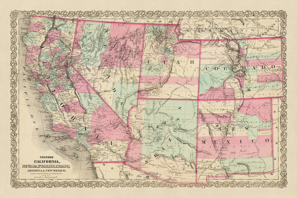
Step back in time with this beautifully detailed old map of California, Nevada, Utah, Colorado, and Arizona & New Mexico, created by J.H. Colton in 1871. Colton, widely regarded as the finest American mapmaker of his era, meticulously captured the landscape of the Western United States in the early years of the country's history. This map is a testament to his talent and a fascinating snapshot of a time when the region was still largely uncharted and continuously evolving.
In 1871, the United States was a young nation, its western territories still largely unexplored and unsettled. Many of the settlements that we now know were not yet founded, and the names and borders of those that did exist have likely changed in the last 150 years. This map is a window into that era, offering a unique perspective on the history and development of the Western United States.
The map features the five most notable settlements in these territories as of 1855: San Francisco, Salt Lake City, Denver, Tucson, and Santa Fe. Each of these cities has a rich history, and their inclusion on this map is a testament to their significance during this formative period in American history. The map offers a detailed view of these cities and their surrounding areas, providing a fascinating glimpse into their early development.
The quality of this map is a testament to Colton's craftsmanship. Each detail is meticulously rendered, from the topography of the land to the intricacies of the settlements. The map is not only a historical artifact but also a work of art, a testament to the skill and dedication of its creator.
The map is an excellent addition to any collection, a conversation piece that will undoubtedly draw attention. It's not just a map; it's a piece of history, a snapshot of a time and place that is long gone but still resonates in the present. This map is a tangible connection to the past, a way to explore the history of the United States in a unique and engaging way.
In conclusion, this old map of California, Nevada, Utah, Colorado, and Arizona & New Mexico by J.H. Colton is a treasure trove of historical information and a beautiful artifact. Its detailed depiction of the Western United States in 1871, featuring the five most notable settlements of the time, makes it a valuable piece for any collector or history enthusiast. This map is more than just a piece of paper; it's a journey back in time, a window into the past, and a testament to the skill and artistry of one of America's finest mapmakers.
California
- San Francisco (1776): Originally known as Yerba Buena, San Francisco is notable for the Gold Rush of 1849, which dramatically increased its population and economic importance.
- Los Angeles (1781): Originally named El Pueblo de Nuestra Señora la Reina de los Ángeles, it's one of the oldest and most populous cities in California.
- San Diego (1769): The first European settlement in California, known for its natural harbor and strategic location.
- Sacramento (1848): Founded during the Gold Rush, it served as a key distribution point, commercial center, and agricultural hub.
- San Jose (1777): Known as El Pueblo de San José de Guadalupe, it was the first civilian town in the Spanish colony of Nueva California.
Nevada
- Carson City (1858): Named after the famous frontiersman Kit Carson, it became the capital of Nevada in 1864.
- Virginia City (1859): Known for the Comstock Lode, the first major silver deposit discovery in the United States.
- Reno (1868): Named after Civil War General Jesse Reno, it's known for its casinos and proximity to Lake Tahoe.
Utah
- Salt Lake City (1847): Founded by Brigham Young and other Mormon pioneers, it's the world headquarters of The Church of Jesus Christ of Latter-day Saints.
- Provo (1849): Named for the French-Canadian explorer Étienne Provost, it's home to Brigham Young University.
Colorado
- Denver (1858): Founded during the Pike's Peak Gold Rush, it's known for its mining history.
- Colorado Springs (1871): Known for its scenic beauty and proximity to Pikes Peak.
- Golden (1859): Named for the gold found in the area, it was the territorial capital until 1867.
Arizona & New Mexico
- Tucson (1775): Originally a Spanish military fort, it's one of the oldest continuously inhabited places in the United States.
- Santa Fe (1610): Known as the oldest state capital in the United States, it was originally occupied by Pueblo Indians.
- Albuquerque (1706): Founded as a Spanish colonial outpost, it's known for its rich cultural history.
- Taos (1615): Known for Taos Pueblo, a multi-story adobe complex inhabited for over a thousand years.
- Las Cruces (1849): Established during the Mexican-American War, it's known for its agriculture and military history.
- Prescott (1864): Named after historian William H. Prescott, it was the territorial capital of Arizona.
- Phoenix (1867): Named after the mythical bird, it symbolized the city's emergence from the ruins of the Hohokam civilization.
Native American Tribes
- Navajo Nation: The largest reservation in the United States, located in parts of Arizona, New Mexico, and Utah.
- Ute Indian Tribe: Native to the Great Basin, they inhabited parts of present-day Utah and Colorado.
- Apache Tribes: Known for their fierce resistance against the encroachment of Mexican and American settlers.
- Pueblo Indians: Known for their unique architecture and cultivation of maize.
Natural Attractions
- Grand Canyon: A world-renowned natural wonder located in Arizona.
- Yosemite National Park: Known for its waterfalls, deep valleys, and ancient giant sequoias.
- Death Valley: The hottest, driest, and lowest national park in the United States.
- Rocky Mountains: A major mountain range in western North America, stretching from the northernmost part of British Columbia, in western Canada, to New Mexico.
Historical Events
- Mexican-American War (1846-1848): Led to the Treaty of Guadalupe Hidalgo, which ceded California, Nevada, Utah, and parts of Colorado, Arizona, and New Mexico to the United States.
- California Gold Rush (1848-1855): Attracted hundreds of thousands of prospectors to the region, significantly impacting its demographic, economic, and cultural history.
- Construction of the First Transcontinental Railroad (1863-1869): Connected the Western and Eastern coasts of the United States, significantly reducing travel time across the country.
Please double check the images to make sure that a specific town or place is shown on this map. You can also get in touch and ask us to check the map for you.
This map looks great at all sizes: 18x12in (46x30.5cm), 18x24in (45.5x61cm), 24x36in (61x91.5cm), 30x45in (76x114.5cm), 33x50in (84x127cm), 40x60in (102x153cm) and 47x70in (120x178cm), but it looks even better when printed large.
I can create beautiful, large prints of this map up to 100in (254cm). Please get in touch if you're looking for larger, customised or different framing options.
The model in the listing images is holding the 16x20in (40.5x51cm) version of this map.
The fifth listing image shows an example of my map personalisation service.
The labels on this map are very small at 12x16in (30.5x41cm). The map is still very attractive, but you may struggle to read the smallest letters. Please buy a larger map if it's important to be able to read the map easily.
If you’re looking for something slightly different, check out my main collection of USA and North America maps.
Please contact me to check if a certain location, landmark or feature is shown on this map.
This would make a wonderful birthday, Christmas, Father's Day, work leaving, anniversary or housewarming gift for someone from the areas covered by this map.
This map is available as a giclée print on acid free archival matte paper, or you can buy it framed. The frame is a nice, simple black frame that suits most aesthetics. Please get in touch if you'd like a different frame colour or material. My frames are glazed with super-clear museum-grade acrylic (perspex/acrylite), which is significantly less reflective than glass, safer, and will always arrive in perfect condition.
This map is also available as a float framed canvas, sometimes known as a shadow gap framed canvas or canvas floater. The map is printed on artist's cotton canvas and then stretched over a handmade box frame. We then "float" the canvas inside a wooden frame, which is available in a range of colours (black, dark brown, oak, antique gold and white). This is a wonderful way to present a map without glazing in front. See some examples of float framed canvas maps and explore the differences between my different finishes.
For something truly unique, this map is also available in "Unique 3D", our trademarked process that dramatically transforms the map so that it has a wonderful sense of depth. We combine the original map with detailed topography and elevation data, so that mountains and the terrain really "pop". For more info and examples of 3D maps, check my Unique 3D page.
For most orders, delivery time is about 3 working days. Personalised and customised products take longer, as I have to do the personalisation and send it to you for approval, which usually takes 1 or 2 days.
Please note that very large framed orders usually take longer to make and deliver.
If you need your order to arrive by a certain date, please contact me before you order so that we can find the best way of making sure you get your order in time.
I print and frame maps and artwork in 23 countries around the world. This means your order will be made locally, which cuts down on delivery time and ensures that it won't be damaged during delivery. You'll never pay customs or import duty, and we'll put less CO2 into the air.
All of my maps and art prints are well packaged and sent in a rugged tube if unframed, or surrounded by foam if framed.
I try to send out all orders within 1 or 2 days of receiving your order, though some products (like face masks, mugs and tote bags) can take longer to make.
If you select Express Delivery at checkout your order we will prioritise your order and send it out by 1-day courier (Fedex, DHL, UPS, Parcelforce).
Next Day delivery is also available in some countries (US, UK, Singapore, UAE) but please try to order early in the day so that we can get it sent out on time.
My standard frame is a gallery style black ash hardwood frame. It is simple and quite modern looking. My standard frame is around 20mm (0.8in) wide.
I use super-clear acrylic (perspex/acrylite) for the frame glass. It's lighter and safer than glass - and it looks better, as the reflectivity is lower.
Six standard frame colours are available for free (black, dark brown, dark grey, oak, white and antique gold). Custom framing and mounting/matting is available if you're looking for something else.
Most maps, art and illustrations are also available as a framed canvas. We use matte (not shiny) cotton canvas, stretch it over a sustainably sourced box wood frame, and then 'float' the piece within a wood frame. The end result is quite beautiful, and there's no glazing to get in the way.
All frames are provided "ready to hang", with either a string or brackets on the back. Very large frames will have heavy duty hanging plates and/or a mounting baton. If you have any questions, please get in touch.
See some examples of my framed maps and framed canvas maps.
Alternatively, I can also supply old maps and artwork on canvas, foam board, cotton rag and other materials.
If you want to frame your map or artwork yourself, please read my size guide first.
My maps are extremely high quality reproductions of original maps.
I source original, rare maps from libraries, auction houses and private collections around the world, restore them at my London workshop, and then use specialist giclée inks and printers to create beautiful maps that look even better than the original.
My maps are printed on acid-free archival matte (not glossy) paper that feels very high quality and almost like card. In technical terms the paper weight/thickness is 10mil/200gsm. It's perfect for framing.
I print with Epson ultrachrome giclée UV fade resistant pigment inks - some of the best inks you can find.
I can also make maps on canvas, cotton rag and other exotic materials.
Learn more about The Unique Maps Co.
Map personalisation
If you're looking for the perfect anniversary or housewarming gift, I can personalise your map to make it truly unique. For example, I can add a short message, or highlight an important location, or add your family's coat of arms.
The options are almost infinite. Please see my map personalisation page for some wonderful examples of what's possible.
To order a personalised map, select "personalise your map" before adding it to your basket.
Get in touch if you're looking for more complex customisations and personalisations.
Map ageing
I have been asked hundreds of times over the years by customers if they could buy a map that looks even older.
Well, now you can, by selecting Aged before you add a map to your basket.
All the product photos you see on this page show the map in its Original form. This is what the map looks like today.
If you select Aged, I will age your map by hand, using a special and unique process developed through years of studying old maps, talking to researchers to understand the chemistry of aging paper, and of course... lots of practice!
If you're unsure, stick to the Original colour of the map. If you want something a bit darker and older looking, go for Aged.
If you are not happy with your order for any reason, contact me and I'll get it fixed ASAP, free of charge. Please see my returns and refund policy for more information.
I am very confident you will like your restored map or art print. I have been doing this since 1984. I'm a 5-star Etsy seller. I have sold tens of thousands of maps and art prints and have over 5,000 real 5-star reviews. My work has been featured in interior design magazines, on the BBC, and on the walls of dozens of 5-star hotels.
I use a unique process to restore maps and artwork that is massively time consuming and labour intensive. Hunting down the original maps and illustrations can take months. I use state of the art and eye-wateringly expensive technology to scan and restore them. As a result, I guarantee my maps and art prints are a cut above the rest. I stand by my products and will always make sure you're 100% happy with what you receive.
Almost all of my maps and art prints look amazing at large sizes (200cm, 6.5ft+) and I can frame and deliver them to you as well, via special oversized courier. Contact me to discuss your specific needs.
Or try searching for something!


