


Pictorial Map of Hawaii by Ruth Taylor White, 1935: Honolulu, Hilo, Volcanoes, Plantations, Surfing
20% off 2 — 33% off 3
Add any two eligible items to your bag to receive 20% off. Add a third and it will be complimentary (equivalent to 33% off when purchasing three).
No code needed — the offer applies automatically at checkout.
Valid on all standard maps and fine art prints. You can mix and match any designs.
If you’d like to ship items to multiple addresses, please contact us before placing your order.
Custom and bespoke commissions are excluded.
Contact us if you have any questions
- All taxes and duties included
- Handmade & dispatched in 1-2 days
-
Complimentary gifting & design advice
ⓘ
Complimentary gifting & design advice
Available almost 24/7 on WhatsApp and email — we usually reply within minutes. We can help you:
- Choose a perfectly personalised gift
- Send a digital gift preview to the recipient
- Pick the ideal size for your wall
- Select the right finish and frame
Quick, friendly advice so you can order with confidence.
For last minute gifts, consider buying a digital gift card. We have over 5,000 maps and art prints to choose from.
-
90-day returns & 5-year guarantee
ⓘ
90-day returns & 5-year guarantee
Products can be returned within 90 days for a full refund, or exchange for another product.
We are also proud to offer a 5-year quality guarantee on our maps and art, covering defects in materials or workmanship under normal use.
For personalised and custom made items, we may offer you store credit or a non-expiring gift card, as we cannot resell personalised orders.
If you have any questions, get in touch. For more information, see our full returns & exchanges policy.

This is a museum-grade archival print from the original 1935 map — restored in our workshop and made to order on 220gsm archival matte paper or 400gsm artist's cotton canvas with pigment inks.
Professional framing & free personalisation available.
1. Choose a size
2. Frame & personalise your map
Make your map unique with framing, hand-drawn customisation, vintage ageing, pop art text, unique 3D styling and more.


Gift message & custom finish

If you want to add a gift message, or a finish (jigsaw, aluminium board, etc.) that is not available here, please request it in the "order note" when you check out.
Every order is custom made, so if you need the size adjusted slightly, or printed on an unusual material, just let us know. We've done thousands of custom orders over the years, so there's (almost) nothing we can't manage.
You can also contact us before you order, if you prefer!

- Handmade locally. No import duty or tax
- FREE worldwide delivery
- 90-day returns & 5-year product guarantee
- Questions? WhatsApp me any time
Own a piece of history
7,000+ 5 star reviews


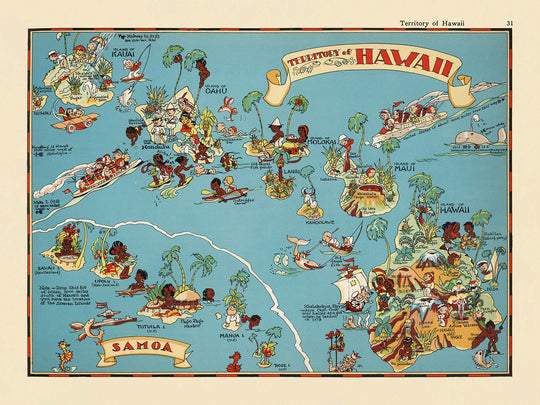
Step into the vibrant world of 1930s Hawaii with the captivating "Territory of Hawaii" map, originally crafted by the celebrated Ruth Taylor White in 1935. This remarkable pictorial map is more than a simple cartographic document; it is a visual homage to the unique character and spirit of the Hawaiian Islands during their territorial era. The original title, “Territory of Hawaii,” situates the map firmly in a transformative period before statehood, when the islands were still an exotic outpost in the American imagination. White’s artistic vision breathes life into the geography, inviting viewers to experience Hawaii as it was seen through the eyes of both locals and curious visitors of the time.
Ruth Taylor White, renowned for her whimsical and richly illustrated maps, brings her signature style to this piece. Her work is characterized by a playful yet informative approach, blending meticulous geographic detail with charming caricatures and lively scenes. The map’s design bursts with color and personality, transforming the Hawaiian archipelago into a tapestry of cultural vignettes and natural wonders. White’s illustrations deftly capture the lush landscapes, from verdant forests and towering volcanoes to the sparkling blue of the Pacific Ocean, all rendered with a delightful sense of humor and artistic flair.
The context of this map’s creation is as fascinating as its imagery. Produced as part of a pictorial atlas intended to introduce Americans to the diverse regions of the United States, the map reflects the era’s fascination with Hawaii’s exoticism and allure. The illustrations are imbued with period-typical stereotypes, offering a snapshot of how the islands were perceived by mainland audiences in the 1930s. Yet, beneath the whimsy, the map serves as a valuable historical artifact, documenting both the cultural icons and the economic activities that defined Hawaii during its territorial years, such as sugar cane and pineapple plantations, hula dancing, and early tourism.
A closer look at the map reveals a rich array of natural and cultural landmarks. Majestic volcanoes, likely representing the legendary Kilauea or Mauna Loa, erupt with energy, while palm-fringed beaches and tropical flora evoke the islands’ paradisiacal beauty. The ocean teems with outrigger canoes and marine life, reflecting the deep connection between Hawaiians and the sea. Scenes of traditional life—fishing, surfing, and dancing—unfold alongside caricatures of tourists, capturing the burgeoning allure of Hawaii as a destination for adventure and relaxation. The map’s borders are adorned with additional thematic illustrations, further immersing the viewer in the islands’ enchanting world.
Among the most intriguing features of the map are the settlements that would become the vibrant cities and towns of modern Hawaii. Honolulu, now a bustling metropolis, stands alongside historic Hilo, Kahului, and Lahaina, each depicted with a sense of charm and individuality. These communities, nestled amid mountains, forests, and coastlines, are presented not just as points on a map, but as living centers of culture and commerce. Through Ruth Taylor White’s masterful artistry, the “Territory of Hawaii” map offers a window into a bygone era, inviting collectors and enthusiasts to own a piece of Hawaiian history rendered in unforgettable detail.
Cities and towns on this map
- Honolulu
- Hilo
- Kahului
- Wailuku
- Lihue
- Waimea (Kauai)
- Lahaina
- Kailua (Hawaii Island)
- Hāna
Notable Features & Landmarks
- Illustrations of volcanoes, including an erupting volcano (likely representing Kilauea or Mauna Loa)
- Depictions of tropical vegetation, such as palm trees and lush forests
- Drawings of native Hawaiian people engaged in traditional activities (e.g., hula dancing, surfing, fishing)
- Representations of sugar cane and pineapple plantations
- Images of outrigger canoes and boats in the surrounding ocean
- Illustrations of marine life, such as fish and possibly turtles
- Artistic renderings of mountains and the varied terrain of the islands
- Visual references to Hawaiian cultural symbols, such as leis and grass skirts
- Caricatures of tourists and scenes of leisure, reflecting the early tourism industry
- The map’s border is decorated with additional thematic illustrations related to Hawaii
Historical and design context
- Name of the map: Territory of Hawaii
- Date created: 1935
- Mapmaker: Ruth Taylor White
- The map is a county or state thematic and pictorial map, featuring vibrant, cartoon-like illustrations
- Created when Hawaii was still a U.S. territory (before statehood in 1959), reflecting contemporary American perceptions of Hawaii
- Part of a whimsical pictorial or cartoon atlas of the United States, known for its colorful and engaging style
- The illustrations highlight unique features of Hawaii, including traditional dress, activities, and natural scenery, as seen through the lens of the 1930s
- The map is an example of early 20th-century pictorial cartography, blending geography with popular culture and art
Please double check the images to make sure that a specific town or place is shown on this map. You can also get in touch and ask us to check the map for you.
This map looks great at every size, but I always recommend going for a larger size if you have space. That way you can easily make out all of the details.
This map looks amazing at sizes all the way up to 50in (125cm). If you are looking for a larger map, please get in touch.
The model in the listing images is holding the 18x24in (45x60cm) version of this map.
The fifth listing image shows an example of my map personalisation service.
If you’re looking for something slightly different, check out my collection of the best old maps to see if something else catches your eye.
Please contact me to check if a certain location, landmark or feature is shown on this map.
This would make a wonderful birthday, Christmas, Father's Day, work leaving, anniversary or housewarming gift for someone from the areas covered by this map.
This map is available as a giclée print on acid free archival matte paper, or you can buy it framed. The frame is a nice, simple black frame that suits most aesthetics. Please get in touch if you'd like a different frame colour or material. My frames are glazed with super-clear museum-grade acrylic (perspex/acrylite), which is significantly less reflective than glass, safer, and will always arrive in perfect condition.
This map is also available as a float framed canvas, sometimes known as a shadow gap framed canvas or canvas floater. The map is printed on artist's cotton canvas and then stretched over a handmade box frame. We then "float" the canvas inside a wooden frame, which is available in a range of colours (black, dark brown, oak, antique gold and white). This is a wonderful way to present a map without glazing in front. See some examples of float framed canvas maps and explore the differences between my different finishes.
For something truly unique, this map is also available in "Unique 3D", our trademarked process that dramatically transforms the map so that it has a wonderful sense of depth. We combine the original map with detailed topography and elevation data, so that mountains and the terrain really "pop". For more info and examples of 3D maps, check my Unique 3D page.
For most orders, delivery time is about 3 working days. Personalised and customised products take longer, as I have to do the personalisation and send it to you for approval, which usually takes 1 or 2 days.
Please note that very large framed orders usually take longer to make and deliver.
If you need your order to arrive by a certain date, please contact me before you order so that we can find the best way of making sure you get your order in time.
I print and frame maps and artwork in 23 countries around the world. This means your order will be made locally, which cuts down on delivery time and ensures that it won't be damaged during delivery. You'll never pay customs or import duty, and we'll put less CO2 into the air.
All of my maps and art prints are well packaged and sent in a rugged tube if unframed, or surrounded by foam if framed.
I try to send out all orders within 1 or 2 days of receiving your order, though some products (like face masks, mugs and tote bags) can take longer to make.
If you select Express Delivery at checkout your order we will prioritise your order and send it out by 1-day courier (Fedex, DHL, UPS, Parcelforce).
Next Day delivery is also available in some countries (US, UK, Singapore, UAE) but please try to order early in the day so that we can get it sent out on time.
My standard frame is a gallery style black ash hardwood frame. It is simple and quite modern looking. My standard frame is around 20mm (0.8in) wide.
I use super-clear acrylic (perspex/acrylite) for the frame glass. It's lighter and safer than glass - and it looks better, as the reflectivity is lower.
Six standard frame colours are available for free (black, dark brown, dark grey, oak, white and antique gold). Custom framing and mounting/matting is available if you're looking for something else.
Most maps, art and illustrations are also available as a framed canvas. We use matte (not shiny) cotton canvas, stretch it over a sustainably sourced box wood frame, and then 'float' the piece within a wood frame. The end result is quite beautiful, and there's no glazing to get in the way.
All frames are provided "ready to hang", with either a string or brackets on the back. Very large frames will have heavy duty hanging plates and/or a mounting baton. If you have any questions, please get in touch.
See some examples of my framed maps and framed canvas maps.
Alternatively, I can also supply old maps and artwork on canvas, foam board, cotton rag and other materials.
If you want to frame your map or artwork yourself, please read my size guide first.
My maps are extremely high quality reproductions of original maps.
I source original, rare maps from libraries, auction houses and private collections around the world, restore them at my London workshop, and then use specialist giclée inks and printers to create beautiful maps that look even better than the original.
My maps are printed on acid-free archival matte (not glossy) paper that feels very high quality and almost like card. In technical terms the paper weight/thickness is 10mil/200gsm. It's perfect for framing.
I print with Epson ultrachrome giclée UV fade resistant pigment inks - some of the best inks you can find.
I can also make maps on canvas, cotton rag and other exotic materials.
Learn more about The Unique Maps Co.
Map personalisation
If you're looking for the perfect anniversary or housewarming gift, I can personalise your map to make it truly unique. For example, I can add a short message, or highlight an important location, or add your family's coat of arms.
The options are almost infinite. Please see my map personalisation page for some wonderful examples of what's possible.
To order a personalised map, select "personalise your map" before adding it to your basket.
Get in touch if you're looking for more complex customisations and personalisations.
Map ageing
I have been asked hundreds of times over the years by customers if they could buy a map that looks even older.
Well, now you can, by selecting Aged before you add a map to your basket.
All the product photos you see on this page show the map in its Original form. This is what the map looks like today.
If you select Aged, I will age your map by hand, using a special and unique process developed through years of studying old maps, talking to researchers to understand the chemistry of aging paper, and of course... lots of practice!
If you're unsure, stick to the Original colour of the map. If you want something a bit darker and older looking, go for Aged.
If you are not happy with your order for any reason, contact me and I'll get it fixed ASAP, free of charge. Please see my returns and refund policy for more information.
I am very confident you will like your restored map or art print. I have been doing this since 1984. I'm a 5-star Etsy seller. I have sold tens of thousands of maps and art prints and have over 5,000 real 5-star reviews. My work has been featured in interior design magazines, on the BBC, and on the walls of dozens of 5-star hotels.
I use a unique process to restore maps and artwork that is massively time consuming and labour intensive. Hunting down the original maps and illustrations can take months. I use state of the art and eye-wateringly expensive technology to scan and restore them. As a result, I guarantee my maps and art prints are a cut above the rest. I stand by my products and will always make sure you're 100% happy with what you receive.
Almost all of my maps and art prints look amazing at large sizes (200cm, 6.5ft+) and I can frame and deliver them to you as well, via special oversized courier. Contact me to discuss your specific needs.
Or try searching for something!


