


Rare Old Plan Map of Rome, 1921: Vatican, Colosseum, Trevi Fountain, Via del Corso, Roman Forum
Buy 2, Get 1 More Free
If you add 2 items to your bag, you can add a third product for free. The discount is automatic - no code required.
This is equivalent to 33% off, which will be the largest discount available on my shop this year.
This works for all maps and artwork. You can order 3 of the same thing, or 3 different things.
Custom maps are excluded, as they're too time consuming to make and we'd prefer to take our time rather than rush through a lot of orders.
Contact me if you have any questions.
- All taxes and duties included
- Handmade & dispatched in 1-2 days
-
Complimentary gifting & design advice
ⓘ
Complimentary gifting & design advice
Available almost 24/7 on WhatsApp and email — we usually reply within minutes. We can help you:
- Choose a perfectly personalised gift
- Send a digital gift preview to the recipient
- Pick the ideal size for your wall
- Select the right finish and frame
Quick, friendly advice so you can order with confidence.
For last minute gifts, consider buying a digital gift card. We have over 5,000 maps and art prints to choose from.
-
90-day returns & 5-year guarantee
ⓘ
90-day returns & 5-year guarantee
Products can be returned within 90 days for a full refund, or exchange for another product.
We are also proud to offer a 5-year quality guarantee on our maps and art, covering defects in materials or workmanship under normal use.
For personalised and custom made items, we may offer you store credit or a non-expiring gift card, as we cannot resell personalised orders.
If you have any questions, get in touch. For more information, see our full returns & exchanges policy.

This is a museum-grade archival print from the original 1921 map — restored in our workshop and made to order on 220gsm archival matte paper or 400gsm artist's cotton canvas with pigment inks.
Professional framing & free personalisation available
1. Choose a size
2. Frame & personalise your map
Make your map unique with framing, hand-drawn customisation, vintage ageing, pop art text, unique 3D styling and more.


Gift message & custom finish

If you want to add a gift message, or a finish (jigsaw, aluminium board, etc.) that is not available here, please request it in the "order note" when you check out.
Every order is custom made, so if you need the size adjusted slightly, or printed on an unusual material, just let us know. We've done thousands of custom orders over the years, so there's (almost) nothing we can't manage.
You can also contact us before you order, if you prefer!

- Handmade locally. No import duty or tax
- FREE worldwide delivery
- 90-day returns & 5-year product guarantee
- Questions? WhatsApp me any time
Own a piece of history
7,000+ 5 star reviews


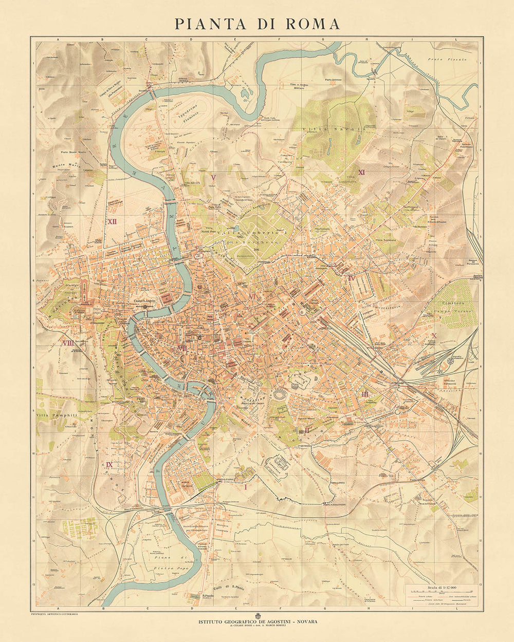
Discover the Eternal City through the "Pianta di Roma"
Immerse yourself in the historical grandeur of Rome with the "Pianta di Roma," a meticulously detailed street map created by the renowned Istituto Geografico De Agostini in 1921. This map captures Rome in a period of transformation, portraying not only the ancient landmarks that have defined the city for millennia but also the modern streets and neighborhoods that give Rome its vibrant, living character. From the spiritual and administrative heart of the Vatican in the west to the bustling, scholarly quarters around Campo Verano in the east, this map offers a comprehensive view of Rome, encapsulating its dual identity as an ancient city and a contemporary capital.
A Cartographic Masterpiece of Urban Complexity
The "Pianta di Roma" is a testament to the complexity and richness of Rome’s urban landscape. It meticulously labels every street, allowing for easy navigation through neighborhoods ranging from the historic Trastevere, known for its winding streets and medieval houses, to the aristocratic Parioli, representing Rome's modern upscale living. The map also highlights significant arteries like Via del Corso and Via Appia Nuova, providing insights into the city’s development and the flow of daily Roman life. The vibrant hues used to delineate the Tiber River enhance the map's aesthetic, making it not just a tool for orientation but a piece of art celebrating Rome’s geographic and cultural tapestry.
Landmarks that Tell Stories of Ages
The historical significance of Rome is vividly captured through its landmarks, each with a story to tell, and the "Pianta di Roma" serves as a guide to these monumental tales. Iconic structures such as the Colosseum, the Pantheon, and St. Peter's Basilica are plotted with precision, offering a snapshot of architectural evolution from ancient times to the Renaissance and beyond. The map also includes gems like the Spanish Steps and the Trevi Fountain, immersing the viewer in the Rome of La Dolce Vita. These landmarks are not merely points on a map but markers of the epochs and events that have shaped the world.
Green Spaces and the Urban Canvas
Amidst the dense historical and urban fabric of Rome, the "Pianta di Roma" also accentuates the city’s green lungs, such as the expansive Villa Borghese and the ancient Appian Way Regional Park. These areas offer a respite from the urban bustle and are crucial for understanding the city's layout and social life. The inclusion of these parks highlights Rome's dedication to preserving natural beauty and historical integrity, providing spaces for relaxation and cultural reflection that are cherished by both residents and visitors alike.
A Legacy of Cartographic Excellence
Produced by Istituto Geografico De Agostini during its founding year, the "Pianta di Roma" not only stands as a valuable historical document but also as a testament to the enduring legacy of Italian cartography. The map’s creation at a pivotal time in both the mapmaker's history and that of the city it represents makes it an invaluable resource for historians, cartographers, and anyone fascinated by the evolution of urban landscapes. Owning this map is akin to possessing a piece of Rome’s storied past, presented through the lens of one of Italy’s most esteemed geographical institutions.
Streets and roads on this map
- Corso Vittorio Emanuele II
- Lungotevere dei Mellini
- Lungotevere della Farnesina
- Lungotevere dei Tebaldi
- Piazza del Popolo
- Piazza di Spagna
- Piazza Navona
- Piazza Venezia
- Via Appia Nuova
- Via Aurelia
- Via Cassia
- Via del Corso
- Via Flaminia
- Via Giulia
- Via Labicana
- Via Latina
- Via Nomentana
- Via Ostiense
- Via Prenestina
- Via Salaria
- Via Tiburtina
- Via Tuscolana
Notable Features & Landmarks
- Colosseum
- Roman Forum
- Palatine Hill
- Circus Maximus
- Baths of Caracalla
- Appian Way
- Catacombs of Rome
- Pantheon
- Trevi Fountain
- Spanish Steps
- Piazza Navona
- Campo de' Fiori
- Castel Sant'Angelo
- Vatican City
- St. Peter's Basilica
- Sistine Chapel
- Vatican Museums
- Piazza Venezia
- Altar of the Fatherland
- Roman Capitol
- Capitoline Museums
- Piazza del Popolo
- Pincio Gardens
- Villa Borghese
- Galleria Borghese
- Quirinal Palace
- Palazzo Barberini
- Palazzo Chigi
- Palazzo Farnese
- Palazzo Spada
- Palazzo Venezia
- Church of Sant'Agnese in Agone
- Church of Sant'Andrea della Valle
- Church of Sant'Angelo in Pescheria
- Church of Sant'Anna dei Palafrenieri
- Church of Sant'Antonio dei Portoghesi
- Church of Sant'Apollinare
- Church of Sant'Atanasio
- Church of Sant'Eustachio
- Church of Sant'Ivo alla Sapienza
- Church of San Luigi dei Francesi
- Church of San Marcello al Corso
- Church of San Marco
- Church of San Nicola in Carcere
- Church of San Pietro in Vincoli
- Church of Santa Maria della Pace
- Church of Santa Maria del Popolo
- Church of Santa Maria in Trastevere
- Church of Santa Maria sopra Minerva
- Mausoleum of Augustus
- Ara Pacis
- Mercati di Traiano
- Torre delle Milizie
- Palazzo delle Esposizioni
- Galleria Nazionale d'Arte Moderna
- Stadio Olimpico
- Foro Italico
- Palazzo della Civiltà Italiana
Historical and design context
- Title: Pianta di Roma
- Date: 1921
- Mapmaker/Publisher: Istituto Geografico De Agostini
- Design or style: Coloured street map in a traditional style, easy to read and understand.
- Historical significance: Provides a snapshot of Rome during a period of significant changes, valuable for understanding the history of cartography and the city's development.
- Interesting context about the mapmaker: Created by Istituto Geografico De Agostini, known for high-quality maps and atlases, founded in the same year the map was made.
- Topics and themes: Showcases streets, landmarks, and geographic features of Rome, including the Tiber River, emphasizing the city's historical and geographical importance.
Please double check the images to make sure that a specific town or place is shown on this map. You can also get in touch and ask us to check the map for you.
This map looks great at every size, but I always recommend going for a larger size if you have space. That way you can easily make out all of the details.
This map looks amazing at sizes all the way up to 70in (180cm). If you are looking for a larger map, please get in touch.
Please note: the labels on this map are hard to read if you order a map that is 16in (40cm) or smaller. The map is still very attractive, but if you would like to read the map easily, please buy a larger size.
The model in the listing images is holding the 16x20in (40x50cm) version of this map.
The fifth listing image shows an example of my map personalisation service.
If you’re looking for something slightly different, check out my collection of the best old maps to see if something else catches your eye.
Please contact me to check if a certain location, landmark or feature is shown on this map.
This would make a wonderful birthday, Christmas, Father's Day, work leaving, anniversary or housewarming gift for someone from the areas covered by this map.
This map is available as a giclée print on acid free archival matte paper, or you can buy it framed. The frame is a nice, simple black frame that suits most aesthetics. Please get in touch if you'd like a different frame colour or material. My frames are glazed with super-clear museum-grade acrylic (perspex/acrylite), which is significantly less reflective than glass, safer, and will always arrive in perfect condition.
This map is also available as a float framed canvas, sometimes known as a shadow gap framed canvas or canvas floater. The map is printed on artist's cotton canvas and then stretched over a handmade box frame. We then "float" the canvas inside a wooden frame, which is available in a range of colours (black, dark brown, oak, antique gold and white). This is a wonderful way to present a map without glazing in front. See some examples of float framed canvas maps and explore the differences between my different finishes.
For something truly unique, this map is also available in "Unique 3D", our trademarked process that dramatically transforms the map so that it has a wonderful sense of depth. We combine the original map with detailed topography and elevation data, so that mountains and the terrain really "pop". For more info and examples of 3D maps, check my Unique 3D page.
For most orders, delivery time is about 3 working days. Personalised and customised products take longer, as I have to do the personalisation and send it to you for approval, which usually takes 1 or 2 days.
Please note that very large framed orders usually take longer to make and deliver.
If you need your order to arrive by a certain date, please contact me before you order so that we can find the best way of making sure you get your order in time.
I print and frame maps and artwork in 23 countries around the world. This means your order will be made locally, which cuts down on delivery time and ensures that it won't be damaged during delivery. You'll never pay customs or import duty, and we'll put less CO2 into the air.
All of my maps and art prints are well packaged and sent in a rugged tube if unframed, or surrounded by foam if framed.
I try to send out all orders within 1 or 2 days of receiving your order, though some products (like face masks, mugs and tote bags) can take longer to make.
If you select Express Delivery at checkout your order we will prioritise your order and send it out by 1-day courier (Fedex, DHL, UPS, Parcelforce).
Next Day delivery is also available in some countries (US, UK, Singapore, UAE) but please try to order early in the day so that we can get it sent out on time.
My standard frame is a gallery style black ash hardwood frame. It is simple and quite modern looking. My standard frame is around 20mm (0.8in) wide.
I use super-clear acrylic (perspex/acrylite) for the frame glass. It's lighter and safer than glass - and it looks better, as the reflectivity is lower.
Six standard frame colours are available for free (black, dark brown, dark grey, oak, white and antique gold). Custom framing and mounting/matting is available if you're looking for something else.
Most maps, art and illustrations are also available as a framed canvas. We use matte (not shiny) cotton canvas, stretch it over a sustainably sourced box wood frame, and then 'float' the piece within a wood frame. The end result is quite beautiful, and there's no glazing to get in the way.
All frames are provided "ready to hang", with either a string or brackets on the back. Very large frames will have heavy duty hanging plates and/or a mounting baton. If you have any questions, please get in touch.
See some examples of my framed maps and framed canvas maps.
Alternatively, I can also supply old maps and artwork on canvas, foam board, cotton rag and other materials.
If you want to frame your map or artwork yourself, please read my size guide first.
My maps are extremely high quality reproductions of original maps.
I source original, rare maps from libraries, auction houses and private collections around the world, restore them at my London workshop, and then use specialist giclée inks and printers to create beautiful maps that look even better than the original.
My maps are printed on acid-free archival matte (not glossy) paper that feels very high quality and almost like card. In technical terms the paper weight/thickness is 10mil/200gsm. It's perfect for framing.
I print with Epson ultrachrome giclée UV fade resistant pigment inks - some of the best inks you can find.
I can also make maps on canvas, cotton rag and other exotic materials.
Learn more about The Unique Maps Co.
Map personalisation
If you're looking for the perfect anniversary or housewarming gift, I can personalise your map to make it truly unique. For example, I can add a short message, or highlight an important location, or add your family's coat of arms.
The options are almost infinite. Please see my map personalisation page for some wonderful examples of what's possible.
To order a personalised map, select "personalise your map" before adding it to your basket.
Get in touch if you're looking for more complex customisations and personalisations.
Map ageing
I have been asked hundreds of times over the years by customers if they could buy a map that looks even older.
Well, now you can, by selecting Aged before you add a map to your basket.
All the product photos you see on this page show the map in its Original form. This is what the map looks like today.
If you select Aged, I will age your map by hand, using a special and unique process developed through years of studying old maps, talking to researchers to understand the chemistry of aging paper, and of course... lots of practice!
If you're unsure, stick to the Original colour of the map. If you want something a bit darker and older looking, go for Aged.
If you are not happy with your order for any reason, contact me and I'll get it fixed ASAP, free of charge. Please see my returns and refund policy for more information.
I am very confident you will like your restored map or art print. I have been doing this since 1984. I'm a 5-star Etsy seller. I have sold tens of thousands of maps and art prints and have over 5,000 real 5-star reviews. My work has been featured in interior design magazines, on the BBC, and on the walls of dozens of 5-star hotels.
I use a unique process to restore maps and artwork that is massively time consuming and labour intensive. Hunting down the original maps and illustrations can take months. I use state of the art and eye-wateringly expensive technology to scan and restore them. As a result, I guarantee my maps and art prints are a cut above the rest. I stand by my products and will always make sure you're 100% happy with what you receive.
Almost all of my maps and art prints look amazing at large sizes (200cm, 6.5ft+) and I can frame and deliver them to you as well, via special oversized courier. Contact me to discuss your specific needs.
Or try searching for something!


