

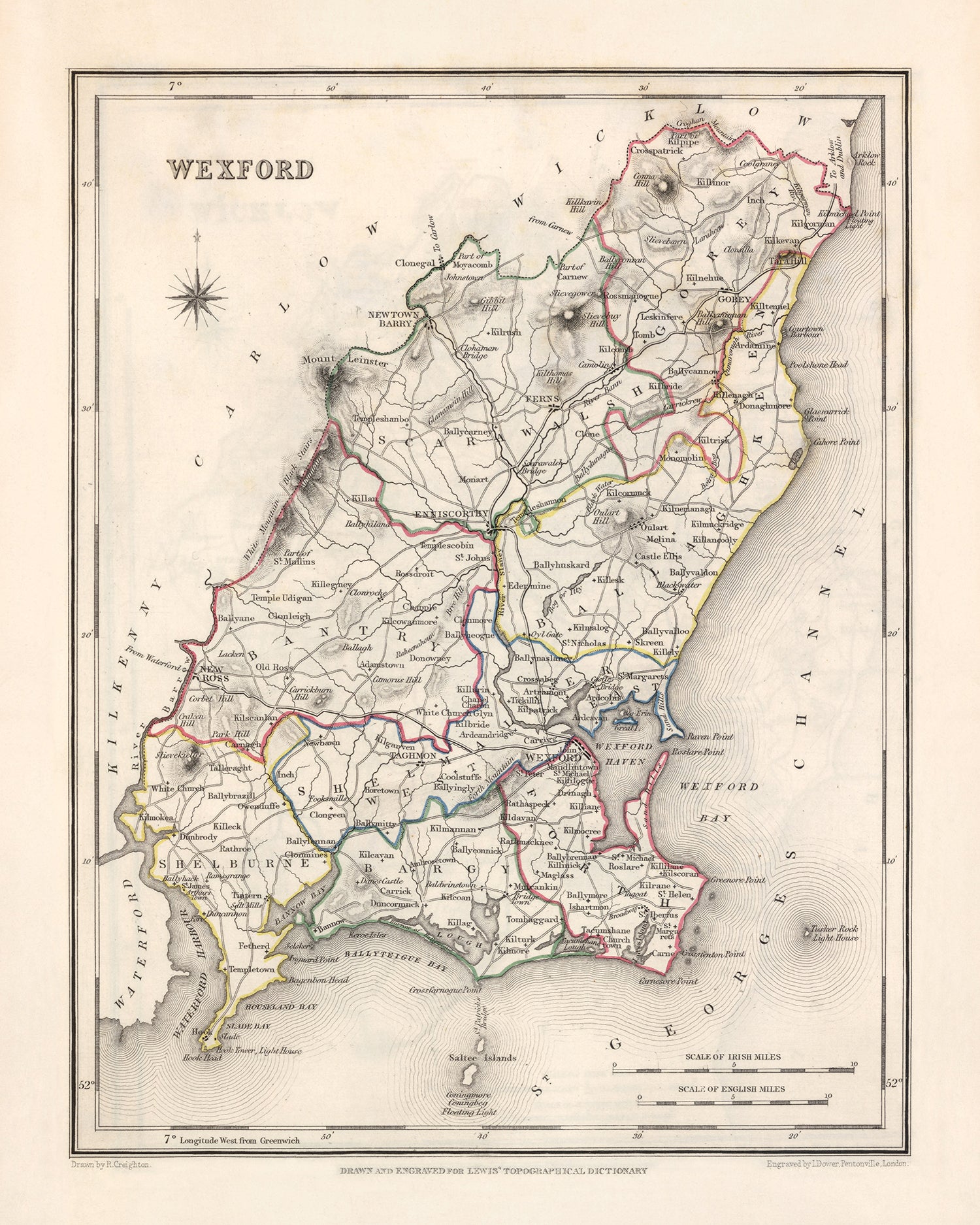
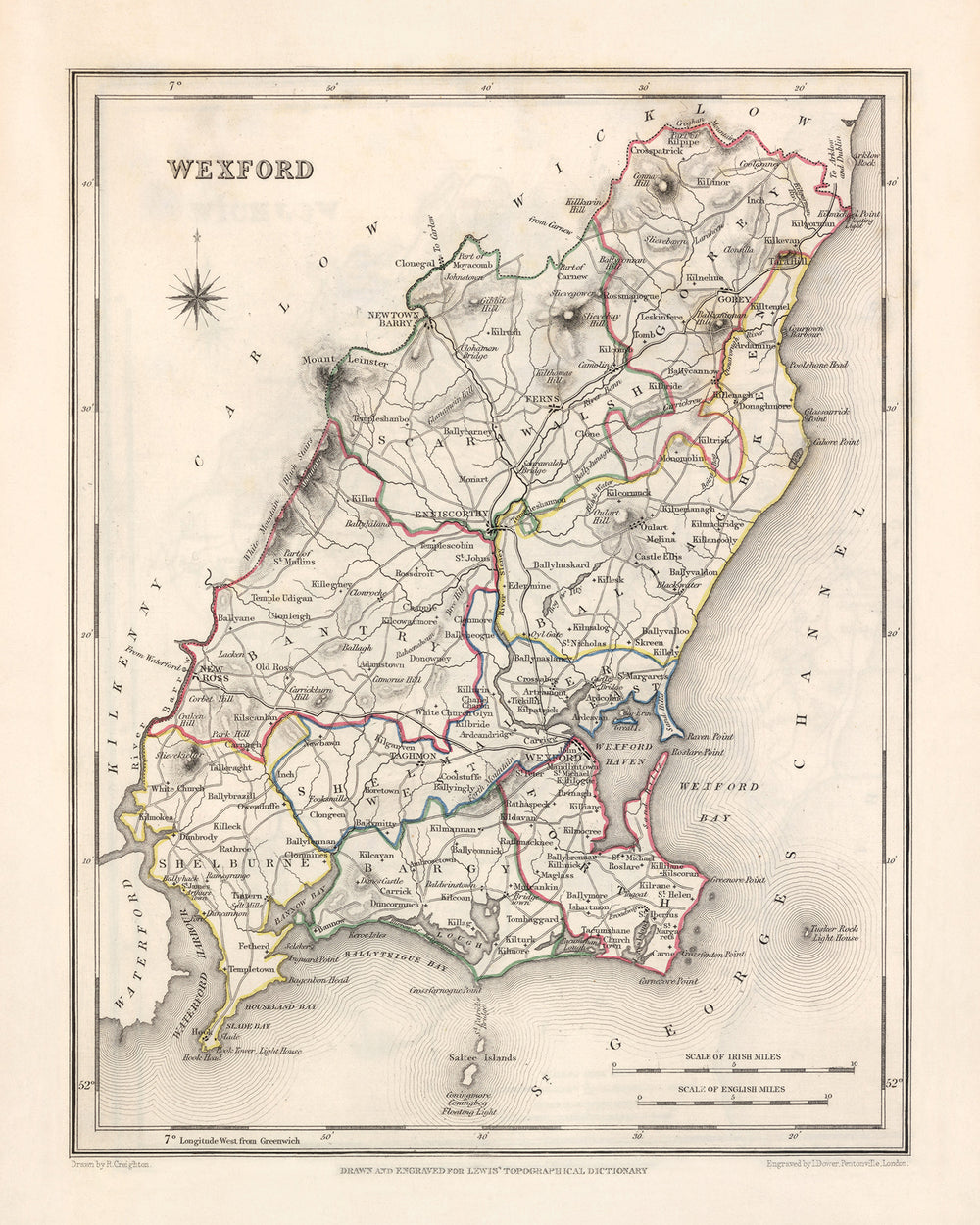


Old Map of County Wexford by Samuel Lewis, 1844: Enniscorthy, New Ross, Gorey, Ferns, and Historical Features
Buy 2, Get 1 More Free
If you add 2 items to your bag, you can add a third product for free. The discount is automatic - no code required.
This is equivalent to 33% off, which will be the largest discount available on my shop this year.
This works for all maps and artwork. You can order 3 of the same thing, or 3 different things.
Custom maps are excluded, as they're too time consuming to make and we'd prefer to take our time rather than rush through a lot of orders.
Contact me if you have any questions.
- All taxes and duties included
- Handmade & dispatched in 1-2 days
-
Complimentary gifting & design advice
ⓘ
Complimentary gifting & design advice
Available almost 24/7 on WhatsApp and email — we usually reply within minutes. We can help you:
- Choose a perfectly personalised gift
- Send a digital gift preview to the recipient
- Pick the ideal size for your wall
- Select the right finish and frame
Quick, friendly advice so you can order with confidence.
For last minute gifts, consider buying a digital gift card. We have over 5,000 maps and art prints to choose from.
-
90-day money back guarantee
ⓘ
90 days to return and refund
Products can be returned within 90 days for a full refund, or exchange for another product.
For personalised and custom made items, we may offer you store credit or a non-expiring gift card, as we cannot resell personalised orders.
If you have any questions, get in touch. For more information, see our full returns & exchanges policy.

This is a museum-grade archival print from the original 1844 map — restored in our workshop and made to order on 220gsm archival matte paper or 400gsm artist's cotton canvas with pigment inks.
Professional framing & free personalisation available
1. Select your size
Click here to order a custom size.
2. Frame & personalise your map
Make your map unique with framing, hand-drawn customisation, vintage ageing, pop art text, unique 3D styling and more.


Gift message & custom finish

If you want to add a gift message, or a finish (jigsaw, aluminium board, etc.) that is not available here, please request it in the "order note" when you check out.
Every order is custom made, so if you need the size adjusted slightly, or printed on an unusual material, just let us know. We've done thousands of custom orders over the years, so there's (almost) nothing we can't manage.
You can also contact us before you order, if you prefer!

- Handmade locally. No import duty or tax
- FREE worldwide delivery
- Love it or your money back (90 days)
- Questions? WhatsApp me any time
Own a piece of history
5,000+ 5 star reviews


The Old Map of Wexford by Samuel Lewis, dated 1844, is a captivating piece that offers a glimpse into the historical landscape of County Wexford, Ireland. This meticulously crafted map showcases the region's rich history, highlighting its major towns, cities, and other intriguing landmarks. While some modern cities may not be present on this map, it is fascinating to discover earlier names and locations of settlements that have since evolved. Owning this map allows you to explore the past and appreciate the changes that have shaped Wexford over the years.
The map features five prominent towns and cities within County Wexford, each with its own unique charm. Enniscorthy, situated on the River Slaney, is a town steeped in history and known for its impressive Enniscorthy Castle. New Ross, located on the River Barrow, is renowned for its connection to the famous emigrant ship, the Dunbrody Famine Ship. Gorey, a market town nestled between the rivers Slaney and Bann, boasts a rich heritage and is home to the splendid Gorey Castle. Ferns, an ancient town with a captivating past, was once the capital of the Kingdom of Leinster. Lastly, this map highlights various historical features that add depth to its allure, making it a remarkable addition to any collection.
Notable settlements founded before 1840 and located within the historical boundaries of County Wexford are as follows:
- Wexford (c. 800): The county town of Wexford, known for its Viking heritage and medieval history.
- Enniscorthy (c. 461): A town with a long-standing history, featuring Enniscorthy Castle and Vinegar Hill.
- New Ross (c. 1207): Home to the Dunbrody Famine Ship and the historic Ros Tapestry.
- Gorey (c. 1608): A market town with a rich heritage, including the impressive Gorey Castle.
- Ferns (c. 200): An ancient town and former capital of the Kingdom of Leinster, featuring the ruins of Ferns Castle.
- Bunclody (c. 1602): A picturesque town located on the River Slaney, offering scenic beauty and historical sites.
- Rosslare (c. 1810): A coastal village known for its sandy beaches and the Rosslare Europort.
- Courtown (c. 1660): A popular seaside resort town with beautiful beaches and Courtown Woods.
- Taghmon (c. 1500): A village with a rich history, including the historic Taghmon Castle.
- Ballycanew (c. 1600): A charming village with a strong sense of community and historical landmarks.
- Castlebridge (c. 1600): A village known for its picturesque setting and proximity to Wexford town.
- Camolin (c. 1600): A village with a rich history, including the ruins of Camolin Castle.
- Kilmore Quay (c. 1600): A scenic fishing village renowned for its maritime heritage and fresh seafood.
- Blackwater (c. 1600): A village situated on the banks of the River Blackwater, offering natural beauty and tranquility.
- Oulart (c. 1600): A village with a storied past, known for its connection to the 1798 Rebellion.
- Duncormick (c. 1600): A picturesque village with a strong sense of community and historical significance.
- Fethard-on-Sea (c. 1600): A coastal village with a rich maritime history and stunning views.
- Kilmore (c. 1600): A village steeped in history, featuring the ruins of Kilmore Castle.
- Clonroche (c. 1600): A village with a rich heritage, including the historic Clonroche Castle.
- Castlebridge (c. 1600): A village known for its picturesque setting and proximity to Wexford town.
- Murrintown (c. 1600): A village offering a glimpse into the region's past, with historical sites and natural beauty.
- Ballymurn (c. 1600): A charming village known for its welcoming atmosphere and historical landmarks.
- Kilrane (c. 1600): A village with a rich maritime history, located near Rosslare Europort.
- Ballygarrett (c. 1600): A coastal village with stunning beaches and a sense of tranquility.
- Bridgetown (c. 1600): A village with a strong sense of community and historical significance.
- Curracloe (c. 1600): A coastal village famous for its beautiful beach, featured in the film "Saving Private Ryan."
- Crossabeg (c. 1600): A village with a rich history, including the historic Crossabeg House.
- Ballyedmond (c. 1600): A village known for its scenic beauty and proximity to the Blackstairs Mountains.
- Killurin (c. 1600): A village offering a glimpse into the region's past, with historical landmarks and natural attractions.
- Ballyhack (c. 1600): A coastal village with a fascinating history, including Ballyhack Castle.
- Tacumshane (c. 1600): A village known for its rural charm and historical significance.
Notable natural features and tourist attractions in County Wexford include the River Slaney, the River Barrow, Vinegar Hill, Enniscorthy Castle, Dunbrody Famine Ship, Ros Tapestry, Gorey Castle, Ferns Castle, Courtown Woods, Kilmore Quay, Blackwater River, and the scenic beaches of Rosslare, Curracloe, and Ballygarrett.
Between 1800 and 1850, County Wexford experienced significant historical events, including the aftermath of the 1798 Rebellion, the rise of the Catholic Emancipation movement, and the impact of the Great Famine. These events shaped the region's history and are integral parts of its narrative during this period.
Owning the Old Map of Wexford by Samuel Lewis, 1844 allows you to delve into the past, explore the historical settlements, and appreciate the beauty and significance of County Wexford, Ireland.
Please double check the images to make sure that a specific town or place is shown on this map. You can also get in touch and ask us to check the map for you.
This map looks great at all sizes: 12x16in (30.5x41cm), 16x20in (40.5x51cm), 18x24in (45.5x61cm), 24x30in (61x76cm), 32x40in (81.5x102cm) and 40x50in (102x127cm), but it looks even better when printed large.
I can create beautiful, large prints of this map up to 50in (127cm). Please get in touch if you're looking for larger, customised or different framing options.
The model in the listing images is holding the 16x20in (40.5x51cm) version of this map.
The fifth listing image shows an example of my map personalisation service.
If you’re looking for something slightly different, check out my main collection of UK and Ireland maps.
Please contact me to check if a certain location, landmark or feature is shown on this map.
This would make a wonderful birthday, Christmas, Father's Day, work leaving, anniversary or housewarming gift for someone from the areas covered by this map.
This map is available as a giclée print on acid free archival matte paper, or you can buy it framed. The frame is a nice, simple black frame that suits most aesthetics. Please get in touch if you'd like a different frame colour or material. My frames are glazed with super-clear museum-grade acrylic (perspex/acrylite), which is significantly less reflective than glass, safer, and will always arrive in perfect condition.
This map is also available as a float framed canvas, sometimes known as a shadow gap framed canvas or canvas floater. The map is printed on artist's cotton canvas and then stretched over a handmade box frame. We then "float" the canvas inside a wooden frame, which is available in a range of colours (black, dark brown, oak, antique gold and white). This is a wonderful way to present a map without glazing in front. See some examples of float framed canvas maps and explore the differences between my different finishes.
For something truly unique, this map is also available in "Unique 3D", our trademarked process that dramatically transforms the map so that it has a wonderful sense of depth. We combine the original map with detailed topography and elevation data, so that mountains and the terrain really "pop". For more info and examples of 3D maps, check my Unique 3D page.
For most orders, delivery time is about 3 working days. Personalised and customised products take longer, as I have to do the personalisation and send it to you for approval, which usually takes 1 or 2 days.
Please note that very large framed orders usually take longer to make and deliver.
If you need your order to arrive by a certain date, please contact me before you order so that we can find the best way of making sure you get your order in time.
I print and frame maps and artwork in 23 countries around the world. This means your order will be made locally, which cuts down on delivery time and ensures that it won't be damaged during delivery. You'll never pay customs or import duty, and we'll put less CO2 into the air.
All of my maps and art prints are well packaged and sent in a rugged tube if unframed, or surrounded by foam if framed.
I try to send out all orders within 1 or 2 days of receiving your order, though some products (like face masks, mugs and tote bags) can take longer to make.
If you select Express Delivery at checkout your order we will prioritise your order and send it out by 1-day courier (Fedex, DHL, UPS, Parcelforce).
Next Day delivery is also available in some countries (US, UK, Singapore, UAE) but please try to order early in the day so that we can get it sent out on time.
My standard frame is a gallery style black ash hardwood frame. It is simple and quite modern looking. My standard frame is around 20mm (0.8in) wide.
I use super-clear acrylic (perspex/acrylite) for the frame glass. It's lighter and safer than glass - and it looks better, as the reflectivity is lower.
Six standard frame colours are available for free (black, dark brown, dark grey, oak, white and antique gold). Custom framing and mounting/matting is available if you're looking for something else.
Most maps, art and illustrations are also available as a framed canvas. We use matte (not shiny) cotton canvas, stretch it over a sustainably sourced box wood frame, and then 'float' the piece within a wood frame. The end result is quite beautiful, and there's no glazing to get in the way.
All frames are provided "ready to hang", with either a string or brackets on the back. Very large frames will have heavy duty hanging plates and/or a mounting baton. If you have any questions, please get in touch.
See some examples of my framed maps and framed canvas maps.
Alternatively, I can also supply old maps and artwork on canvas, foam board, cotton rag and other materials.
If you want to frame your map or artwork yourself, please read my size guide first.
My maps are extremely high quality reproductions of original maps.
I source original, rare maps from libraries, auction houses and private collections around the world, restore them at my London workshop, and then use specialist giclée inks and printers to create beautiful maps that look even better than the original.
My maps are printed on acid-free archival matte (not glossy) paper that feels very high quality and almost like card. In technical terms the paper weight/thickness is 10mil/200gsm. It's perfect for framing.
I print with Epson ultrachrome giclée UV fade resistant pigment inks - some of the best inks you can find.
I can also make maps on canvas, cotton rag and other exotic materials.
Learn more about The Unique Maps Co.
Map personalisation
If you're looking for the perfect anniversary or housewarming gift, I can personalise your map to make it truly unique. For example, I can add a short message, or highlight an important location, or add your family's coat of arms.
The options are almost infinite. Please see my map personalisation page for some wonderful examples of what's possible.
To order a personalised map, select "personalise your map" before adding it to your basket.
Get in touch if you're looking for more complex customisations and personalisations.
Map ageing
I have been asked hundreds of times over the years by customers if they could buy a map that looks even older.
Well, now you can, by selecting Aged before you add a map to your basket.
All the product photos you see on this page show the map in its Original form. This is what the map looks like today.
If you select Aged, I will age your map by hand, using a special and unique process developed through years of studying old maps, talking to researchers to understand the chemistry of aging paper, and of course... lots of practice!
If you're unsure, stick to the Original colour of the map. If you want something a bit darker and older looking, go for Aged.
If you are not happy with your order for any reason, contact me and I'll get it fixed ASAP, free of charge. Please see my returns and refund policy for more information.
I am very confident you will like your restored map or art print. I have been doing this since 1984. I'm a 5-star Etsy seller. I have sold tens of thousands of maps and art prints and have over 5,000 real 5-star reviews. My work has been featured in interior design magazines, on the BBC, and on the walls of dozens of 5-star hotels.
I use a unique process to restore maps and artwork that is massively time consuming and labour intensive. Hunting down the original maps and illustrations can take months. I use state of the art and eye-wateringly expensive technology to scan and restore them. As a result, I guarantee my maps and art prints are a cut above the rest. I stand by my products and will always make sure you're 100% happy with what you receive.
Almost all of my maps and art prints look amazing at large sizes (200cm, 6.5ft+) and I can frame and deliver them to you as well, via special oversized courier. Contact me to discuss your specific needs.
Or try searching for something!


