


Old Map of Devon by Samuel Lewis, 1844: Exeter, Plymouth, Torquay, Paignton, and Barnstaple
20% off 2 — 33% off 3
Add any two eligible items to your bag to receive 20% off. Add a third and it will be complimentary (equivalent to 33% off when purchasing three).
No code needed — the offer applies automatically at checkout.
Valid on all standard maps and fine art prints. You can mix and match any designs.
If you’d like to ship items to multiple addresses, please contact us before placing your order.
Custom and bespoke commissions are excluded.
Contact us if you have any questions
- All taxes and duties included
- Handmade & dispatched in 1-2 days
-
Complimentary gifting & design advice
ⓘ
Complimentary gifting & design advice
Available almost 24/7 on WhatsApp and email — we usually reply within minutes. We can help you:
- Choose a perfectly personalised gift
- Send a digital gift preview to the recipient
- Pick the ideal size for your wall
- Select the right finish and frame
Quick, friendly advice so you can order with confidence.
For last minute gifts, consider buying a digital gift card. We have over 5,000 maps and art prints to choose from.
-
90-day returns & 5-year guarantee
ⓘ
90-day returns & 5-year guarantee
Products can be returned within 90 days for a full refund, or exchange for another product.
We are also proud to offer a 5-year quality guarantee on our maps and art, covering defects in materials or workmanship under normal use.
For personalised and custom made items, we may offer you store credit or a non-expiring gift card, as we cannot resell personalised orders.
If you have any questions, get in touch. For more information, see our full returns & exchanges policy.

This is a museum-grade archival print from the original 1844 map — restored in our workshop and made to order on 220gsm archival matte paper or 400gsm artist's cotton canvas with pigment inks.
Professional framing & free personalisation available.
1. Choose a size
2. Frame & personalise your map
Make your map unique with framing, hand-drawn customisation, vintage ageing, pop art text, unique 3D styling and more.


Gift message & custom finish

If you want to add a gift message, or a finish (jigsaw, aluminium board, etc.) that is not available here, please request it in the "order note" when you check out.
Every order is custom made, so if you need the size adjusted slightly, or printed on an unusual material, just let us know. We've done thousands of custom orders over the years, so there's (almost) nothing we can't manage.
You can also contact us before you order, if you prefer!

- Handmade locally. No import duty or tax
- FREE worldwide delivery
- 90-day returns & 5-year product guarantee
- Questions? WhatsApp me any time
Own a piece of history
7,000+ 5 star reviews


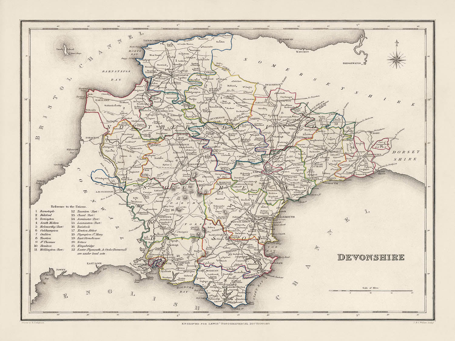
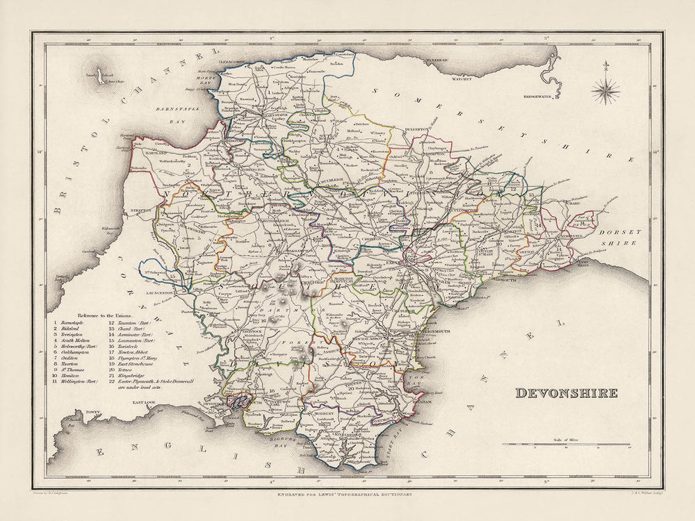
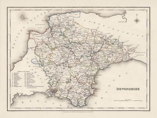
Experience a journey into the past with this exquisite 1844 map of Devonshire by renowned cartographer Samuel Lewis. This stunning relic from the Victorian era is steeped in the rich history of the county, revealing its settlements, geographical features, and historical events. From the bustling cities of Exeter and Plymouth to the picturesque towns along the River Dart, the map paints a vivid picture of Devon's landscape nearly two centuries ago. A treasure for history buffs, cartography enthusiasts, and Devonians alike, it provides a fascinating glimpse into a time when the county's modern cities were either in their infancy or yet to be founded, and some locations might exist under their earlier names.
What makes this map truly remarkable is not just the depth and detail with which it depicts Devonshire, but also its historical significance. Dating back to the mid-19th century, this authentic document offers a snapshot of Devon's settlements and geographical landmarks as they existed prior to significant urban expansion and industrial development. In an age before satellite imagery and GPS technology, Lewis's map is an impressive feat of cartography that faithfully captures Devon's intricate geographical details and vast array of settlements.
Settlements included on this map, ordered by modern day population size:
- Exeter (founded as a Roman fort in AD 55) - Known for its stunning cathedral and rich history.
- Plymouth (founded 1254) - Historic seafaring city and departure point of the Mayflower.
- Torquay (founded 1196) - Famed for its stunning coastline, known as the English Riviera.
- Paignton (records date back to 1086) - A seaside town noted for its zoo and beachfront.
- Barnstaple (founded 930) - The oldest borough in the United Kingdom.
- Newton Abbot (records date back to 1246) - Known for its annual cheese and onion fair.
- Tiverton (founded in the 7th century) - Notable for its historical wool trade.
- Bideford (founded 1272) - Historic port town.
- Exmouth (early references in 12th century) - Known for its seafront and marina.
- Sidmouth (founded before 1086) - A town famous for its Regency architecture.
- Ilfracombe (mentioned in records in 1086) - A seaside resort and harbour.
- Teignmouth (founded before 1044) - Known for its historic port.
- Tavistock (chartered in 1105) - The birthplace of Sir Francis Drake.
- Dawlish (referred to in Domesday book of 1086) - A traditional seaside resort.
- Crediton (founded pre 909) - The historical seat of the first Bishops of Devon.
- Cullompton (settled prehistoric times, town established by 9th century) - Noted for its historic market.
- Totnes (founded pre 907) - Known for its Norman castle.
- Brixham (mentioned in the Domesday Book of 1086) - A fishing town with a rich maritime history.
- Honiton (founded pre Roman times) - Renowned for its lace making.
- Kingsbridge (first recorded in 962) - Located in the South Devon Area of Outstanding Natural Beauty.
- Ivybridge (referred to in documents from 1280) - Known for its paper mills and the beautiful Ivy Bridge.
- Great Torrington (chartered 1340) - Known for its historic connections to the English Civil War.
- Dartmouth (founded pre 12th century) - Known for Dartmouth Castle and its picturesque harbour.
- Ashburton (first recorded 1086) - Ancient stannary town located within Dartmoor National Park.
- Buckfastleigh (referred to in Domesday Book of 1086) - Noted for its historic woollen mill industry.
- Chudleigh (chartered in 1309) - Famous for the Great Fire of Chudleigh in 1807.
- Salcombe (recorded in 1244) - Known for its watersports and as a yachting haven.
- Beer (founded pre-Roman) - Noted for its picturesque cliffs and Quarry Caves.
- Ottery St Mary (referred to in Domesday Book of 1086) - Known for its 'Tar Barrels' tradition.
- Budleigh Salterton (noted in Domesday Book of 1086) - A quaint coastal town known for its pebble beach.
Notable boundaries, rivers, canyons, national parks, and natural phenomena within Devonshire:
- Dartmoor National Park: Known for its moorlands, granite hilltops, and prehistoric sites.
- Exmoor National Park: Famous for its rugged coastline and heather moorlands.
- The Jurassic Coast: A World Heritage Site known for its cliffs and fossil sites.
- River Exe: A major river that flows through the heart of Devon.
- River Dart: Known for its scenic beauty and Dartmouth, its estuary town.
Historical events between 1800 and 1850:
- The opening of the historic Plymouth Dockyard in 1824, a major catalyst for the town's growth.
- The construction of the Tamar Bridge linking Devon to Cornwall in 1859.
- The arrival of the railway in Devon in 1844, which greatly enhanced communication and trade.
So, whether you're a history enthusiast or a lover of Devon, this map provides an exciting and insightful exploration into the past of this remarkable county.
Please double check the images to make sure that a specific town or place is shown on this map. You can also get in touch and ask us to check the map for you.
This map looks great at all sizes: 8x10in (20.5x25.5cm), 12x16in (30.5x41cm), 18x24in (45.5x61cm), 16x20in (40.5x51cm), 24x36in (61x91.5cm), 30x40in (76x101.5cm) and 37x50in (94x127cm), but it looks even better when printed large.
I can create beautiful, large prints of this map up to 50in (127cm). Please get in touch if you're looking for larger, customised or different framing options.
The model in the listing images is holding the 18x24in (45.5x61cm) version of this map.
The fifth listing image shows an example of my map personalisation service.
If you’re looking for something slightly different, check out my main collection of UK and Ireland maps.
Please contact me to check if a certain location, landmark or feature is shown on this map.
This would make a wonderful birthday, Christmas, Father's Day, work leaving, anniversary or housewarming gift for someone from the areas covered by this map.
This map is available as a giclée print on acid free archival matte paper, or you can buy it framed. The frame is a nice, simple black frame that suits most aesthetics. Please get in touch if you'd like a different frame colour or material. My frames are glazed with super-clear museum-grade acrylic (perspex/acrylite), which is significantly less reflective than glass, safer, and will always arrive in perfect condition.
This map is also available as a float framed canvas, sometimes known as a shadow gap framed canvas or canvas floater. The map is printed on artist's cotton canvas and then stretched over a handmade box frame. We then "float" the canvas inside a wooden frame, which is available in a range of colours (black, dark brown, oak, antique gold and white). This is a wonderful way to present a map without glazing in front. See some examples of float framed canvas maps and explore the differences between my different finishes.
For something truly unique, this map is also available in "Unique 3D", our trademarked process that dramatically transforms the map so that it has a wonderful sense of depth. We combine the original map with detailed topography and elevation data, so that mountains and the terrain really "pop". For more info and examples of 3D maps, check my Unique 3D page.
For most orders, delivery time is about 3 working days. Personalised and customised products take longer, as I have to do the personalisation and send it to you for approval, which usually takes 1 or 2 days.
Please note that very large framed orders usually take longer to make and deliver.
If you need your order to arrive by a certain date, please contact me before you order so that we can find the best way of making sure you get your order in time.
I print and frame maps and artwork in 23 countries around the world. This means your order will be made locally, which cuts down on delivery time and ensures that it won't be damaged during delivery. You'll never pay customs or import duty, and we'll put less CO2 into the air.
All of my maps and art prints are well packaged and sent in a rugged tube if unframed, or surrounded by foam if framed.
I try to send out all orders within 1 or 2 days of receiving your order, though some products (like face masks, mugs and tote bags) can take longer to make.
If you select Express Delivery at checkout your order we will prioritise your order and send it out by 1-day courier (Fedex, DHL, UPS, Parcelforce).
Next Day delivery is also available in some countries (US, UK, Singapore, UAE) but please try to order early in the day so that we can get it sent out on time.
My standard frame is a gallery style black ash hardwood frame. It is simple and quite modern looking. My standard frame is around 20mm (0.8in) wide.
I use super-clear acrylic (perspex/acrylite) for the frame glass. It's lighter and safer than glass - and it looks better, as the reflectivity is lower.
Six standard frame colours are available for free (black, dark brown, dark grey, oak, white and antique gold). Custom framing and mounting/matting is available if you're looking for something else.
Most maps, art and illustrations are also available as a framed canvas. We use matte (not shiny) cotton canvas, stretch it over a sustainably sourced box wood frame, and then 'float' the piece within a wood frame. The end result is quite beautiful, and there's no glazing to get in the way.
All frames are provided "ready to hang", with either a string or brackets on the back. Very large frames will have heavy duty hanging plates and/or a mounting baton. If you have any questions, please get in touch.
See some examples of my framed maps and framed canvas maps.
Alternatively, I can also supply old maps and artwork on canvas, foam board, cotton rag and other materials.
If you want to frame your map or artwork yourself, please read my size guide first.
My maps are extremely high quality reproductions of original maps.
I source original, rare maps from libraries, auction houses and private collections around the world, restore them at my London workshop, and then use specialist giclée inks and printers to create beautiful maps that look even better than the original.
My maps are printed on acid-free archival matte (not glossy) paper that feels very high quality and almost like card. In technical terms the paper weight/thickness is 10mil/200gsm. It's perfect for framing.
I print with Epson ultrachrome giclée UV fade resistant pigment inks - some of the best inks you can find.
I can also make maps on canvas, cotton rag and other exotic materials.
Learn more about The Unique Maps Co.
Map personalisation
If you're looking for the perfect anniversary or housewarming gift, I can personalise your map to make it truly unique. For example, I can add a short message, or highlight an important location, or add your family's coat of arms.
The options are almost infinite. Please see my map personalisation page for some wonderful examples of what's possible.
To order a personalised map, select "personalise your map" before adding it to your basket.
Get in touch if you're looking for more complex customisations and personalisations.
Map ageing
I have been asked hundreds of times over the years by customers if they could buy a map that looks even older.
Well, now you can, by selecting Aged before you add a map to your basket.
All the product photos you see on this page show the map in its Original form. This is what the map looks like today.
If you select Aged, I will age your map by hand, using a special and unique process developed through years of studying old maps, talking to researchers to understand the chemistry of aging paper, and of course... lots of practice!
If you're unsure, stick to the Original colour of the map. If you want something a bit darker and older looking, go for Aged.
If you are not happy with your order for any reason, contact me and I'll get it fixed ASAP, free of charge. Please see my returns and refund policy for more information.
I am very confident you will like your restored map or art print. I have been doing this since 1984. I'm a 5-star Etsy seller. I have sold tens of thousands of maps and art prints and have over 5,000 real 5-star reviews. My work has been featured in interior design magazines, on the BBC, and on the walls of dozens of 5-star hotels.
I use a unique process to restore maps and artwork that is massively time consuming and labour intensive. Hunting down the original maps and illustrations can take months. I use state of the art and eye-wateringly expensive technology to scan and restore them. As a result, I guarantee my maps and art prints are a cut above the rest. I stand by my products and will always make sure you're 100% happy with what you receive.
Almost all of my maps and art prints look amazing at large sizes (200cm, 6.5ft+) and I can frame and deliver them to you as well, via special oversized courier. Contact me to discuss your specific needs.
Or try searching for something!


