


Old Pacific-Centric World Map by Hogg, 1794: Cook's Voyages, Drake, Anson, Centred on Australia & New Zealand
Buy 2, Get 1 Free
If you add 2 items to your bag, you can add a third product for free. The discount is automatic - no code required.
This is equivalent to 33% off, which will be the largest discount available on my shop this year.
This works for all maps and artwork. You can order 3 of the same thing, or 3 different things.
My custom maps are excluded, as they're too time consuming to make and we'd prefer to take our time rather than rush through a lot of orders.
Please take advantage of the deal and buy lots of beautiful maps and art for your walls.
Contact me if you have any questions.
- All taxes and duties included
- Handmade & dispatched in 1-2 days
-
FREE gift preview
ⓘ
Digital gift preview
After you complete your order, you can send a beautiful digital preview to the gift recipient. Just provide their email address and we'll do the rest. (Their email address will not be stored or used for any other purpose.)
This is perfect if you're concerned that your order might not arrive in time.
You can also buy a real non-expiring gift card, and email it directly to the recipient, so they can buy their own map or artwork.
-
90 day money back guarantee
ⓘ
90 days to return and refund
Products can be returned within 90 days for a full refund, or exchange for another product.
For personalised and custom made items, we may offer you store credit or a non-expiring gift card, as we cannot resell personalised orders.
If you have any questions, get in touch. For more information, see our full returns & exchanges policy.

My maps are rare, museum-grade, restored old maps sourced from libraries, auction houses and private collections across the globe.
Framing & free personalisation available
1. Select your size
Click here to order a custom size.
2. Frame & personalise your map
Make your map unique with framing, hand-drawn customisation, vintage ageing, pop art text, unique 3D styling and more.


Gift message & custom finish

If you want to add a gift message, or a finish (jigsaw, aluminium board, etc.) that is not available here, please request it in the "order note" when you check out.
Every order is custom made, so if you need the size adjusted slightly, or printed on an unusual material, just let us know. We've done thousands of custom orders over the years, so there's (almost) nothing we can't manage.
You can also contact us before you order, if you prefer!

- Handmade locally. No import duty or tax
- FREE worldwide delivery
- Love it or your money back (90 days)
- Questions? WhatsApp me any time
Own a piece of history
5,000+ 5 star reviews


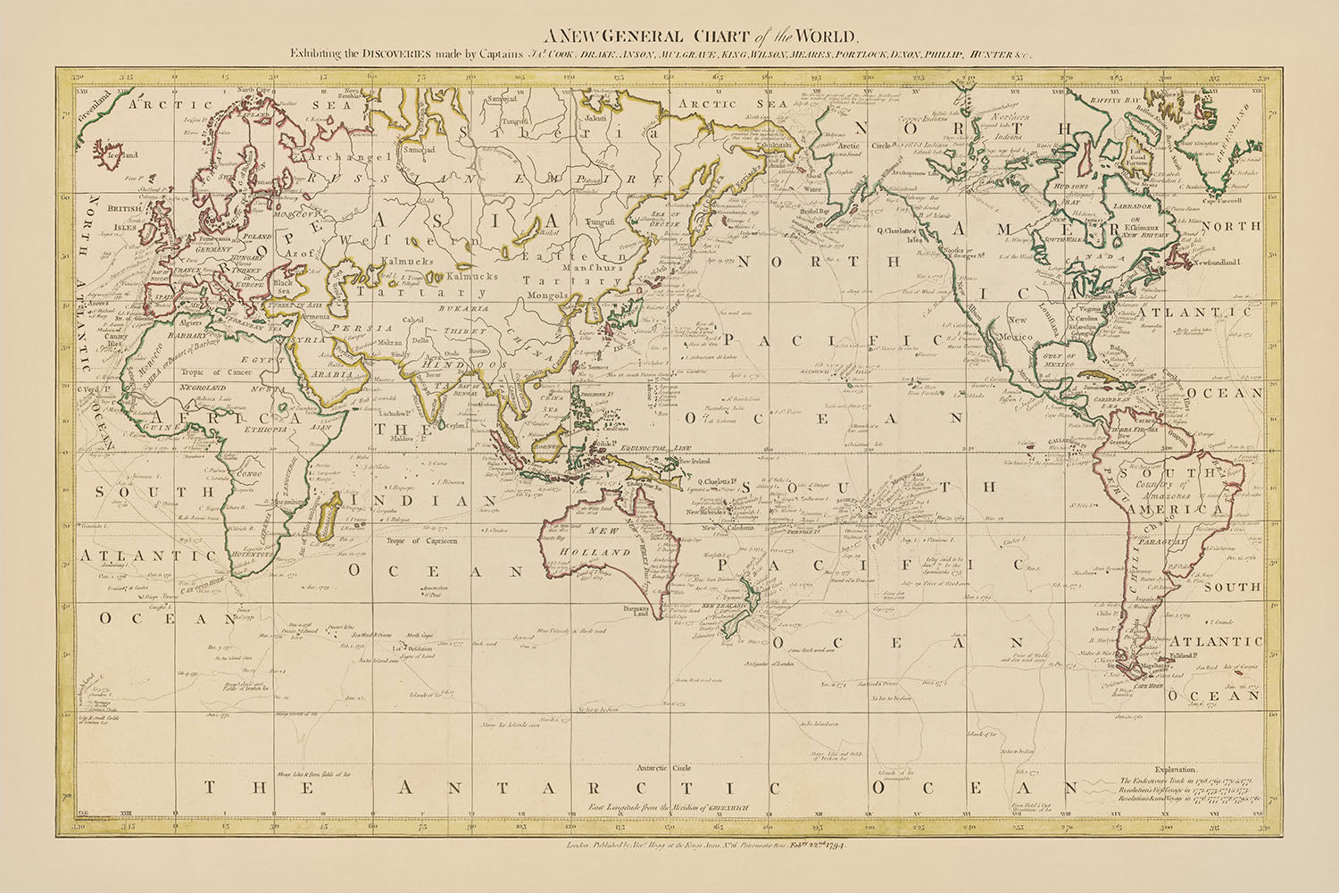
Embark on a voyage through time with "A New General Chart of the World," a captivating masterpiece crafted in 1794 by the esteemed British mapmaker Alexander Hogg. This luxurious cartographic treasure not only serves as a window into the world as it was known in the late 18th century but also commemorates the legendary explorations of Captains James Cook, Drake, Anson, and other luminaries whose voyages reshaped the European understanding of the globe. Hogg, renowned for his precision and attention to detail, has meticulously charted the courses of these intrepid explorers across the vast expanse of the Pacific Ocean, making this map a testament to the era of discovery that expanded the horizons of navigation and geography.
The design and style of this map are a reflection of the cartographic excellence of its time, offering a detailed political view of the world centered around the Pacific Ocean, a perspective that is as rare as it is enlightening. It showcases not only the political boundaries and major cities of the late 18th century but also highlights the natural wonders of the world, from the towering peaks of the Rocky and Andes mountains to the vast waters of the Pacific and Atlantic Oceans. The inclusion of smaller inset maps and additional illustrations, such as "The Track of the Ship Duff" and "A Chart of Botany Bay and Port Jackson," enriches the narrative of exploration and discovery that this map embodies.
Alexander Hogg's "A New General Chart of the World" is distinguished by its comprehensive depiction of the voyages of Captain James Cook, among others, whose expeditions fundamentally altered the European perception of the Pacific and its islands. This map, with its focus on the South Seas and detailed tracks of Cook's voyages, is a celebration of the achievements of an era when explorers ventured beyond known horizons, charting New Zealand, Hawai’i, the Pacific Northwest Coast of North America, and more. The map's Pacific-centric view highlights Cook's significant time spent in these waters, offering a unique perspective on the world that underscores the pivotal role of the Pacific in 18th-century exploration.
The historical and geographical insights provided by this map are further enriched by its depiction of the evolving understanding of regions such as Australia and New Zealand. The connected outline of Australia and Tasmania, known then as Van Diemen’s Land, alongside the toponyms bestowed by Cook and other European explorers, offers a fascinating glimpse into the cartographic knowledge of the time. This map not only charts the physical geography of the world but also captures the momentous shift in understanding the globe's southern lands, marking a significant chapter in the history of exploration.
In essence, Alexander Hogg's "A New General Chart of the World" is not merely a map; it is a historical document of unparalleled value, a masterpiece of cartography that encapsulates the spirit of discovery that defined the 18th century. It invites connoisseurs and collectors alike to delve into the age of exploration, to trace the routes of the world's greatest navigators, and to marvel at the detailed representation of a world on the cusp of becoming fully known. This map is a luxurious artifact, a testament to the enduring allure of the unknown, and a tribute to the explorers who ventured into uncharted waters to bring the world closer together.
Countries and regions on this map
- Africa
- America
- Arctic Sea
- Asia
- Atlantic Ocean
- California
- Canada
- China
- East Indies
- Egypt
- Europe
- Greenland
- Guinea
- Hispaniola
- Hudson Bay
- Iceland
- India
- Japan
- Kamchatka
- Madagascar
- Malacca
- Mexico
- Moluccas
- New Britain
- New Caledonia
- New Found Land
- New Guinea
- New Holland
- New Zealand
- North America
- Norway
- Nova Zembla
- Pacific Ocean
- Peru
- Persia
- Philippine Islands
- Russia
- Sandwich Islands
- Scotland
- Siberia
- Society Islands
- South America
- Spain
- Sumatra
- Sweden
- Tartary
- Terra Australis Incognita
- Turkey
- West Indies
Notable Features & Landmarks
- Bodies of water:
- Pacific Ocean
- Atlantic Ocean
- Indian Ocean
- Arctic Ocean
- North Sea
- Baltic Sea
- Mediterranean Sea
- Caribbean Sea
- Hudson Bay
- Gulf of Mexico
- Persian Gulf
- Red Sea
- Black Sea
- Caspian Sea
- Aral Sea
- Lake Baikal
- Lake Superior
- Lake Huron
- Lake Michigan
- Lake Erie
- Lake Ontario
- Mountain ranges:
- Rocky Mountains
- Andes Mountains
- Appalachian Mountains
- Atlas Mountains
- Ural Mountains
- Alps
- Himalayas
- Kunlun Mountains
- Tien Shan
- Altai Mountains
- Sea, road, and rail routes:
- Northwest Passage
- Northeast Passage
- Cape Horn
- Cape of Good Hope
- Suez Canal
- Panama Canal
- Mississippi River
- Amazon River
- Nile River
- Congo River
- Niger River
- Yangtze River
- Ganges River
- Indus River
- Euphrates River
- Tigris River
- Danube River
- Rhine River
- Volga River
- Great Wall of China
- Silk Road
- Trans-Siberian Railway
- Other interesting features:
- Historical notes or annotations
- Illustrations of ships, sea creatures, and other decorative elements
Historical and design context
- Mapmaker or publisher: Alexander Hogg
- Interesting context related to the mapmaker: Hogg was a British mapmaker known for his detailed and accurate maps, often used for navigation.
- Topics and themes shown on the map: Focus on the Pacific Ocean, including the tracks of the voyages of Captain James Cook and other explorers, political boundaries of the time, major cities, and towns.
- Interesting context related to the topics and themes: The map was published when European exploration of the Pacific Ocean was at its height, highlighting Cook's voyages which were crucial in changing European understanding of the world.
- Context about the design or style of the map: A detailed and accurate representation of the world as known in the 18th century, providing a glimpse into the era of exploration and discovery.
- Historical significance or context of the map: A significant historical document that offers a snapshot of the world in the 18th century, valuable for historians, geographers, and collectors.
Please double check the images to make sure that a specific town or place is shown on this map. You can also get in touch and ask us to check the map for you.
This map looks great at every size, but I always recommend going for a larger size if you have space. That way you can easily make out all of the details.
This map looks amazing at sizes all the way up to 70in (180cm). If you are looking for a larger map, please get in touch.
The model in the listing images is holding the 24x36in (60x90cm) version of this map.
The fifth listing image shows an example of my map personalisation service.
If you’re looking for something slightly different, check out my collection of the best old maps to see if something else catches your eye.
Please contact me to check if a certain location, landmark or feature is shown on this map.
This would make a wonderful birthday, Christmas, Father's Day, work leaving, anniversary or housewarming gift for someone from the areas covered by this map.
This map is available as a giclée print on acid free archival matte paper, or you can buy it framed. The frame is a nice, simple black frame that suits most aesthetics. Please get in touch if you'd like a different frame colour or material. My frames are glazed with super-clear museum-grade acrylic (perspex/acrylite), which is significantly less reflective than glass, safer, and will always arrive in perfect condition.
This map is also available as a float framed canvas, sometimes known as a shadow gap framed canvas or canvas floater. The map is printed on artist's cotton canvas and then stretched over a handmade box frame. We then "float" the canvas inside a wooden frame, which is available in a range of colours (black, dark brown, oak, antique gold and white). This is a wonderful way to present a map without glazing in front. See some examples of float framed canvas maps and explore the differences between my different finishes.
For something truly unique, this map is also available in "Unique 3D", our trademarked process that dramatically transforms the map so that it has a wonderful sense of depth. We combine the original map with detailed topography and elevation data, so that mountains and the terrain really "pop". For more info and examples of 3D maps, check my Unique 3D page.
For most orders, delivery time is about 3 working days. Personalised and customised products take longer, as I have to do the personalisation and send it to you for approval, which usually takes 1 or 2 days.
Please note that very large framed orders usually take longer to make and deliver.
If you need your order to arrive by a certain date, please contact me before you order so that we can find the best way of making sure you get your order in time.
I print and frame maps and artwork in 23 countries around the world. This means your order will be made locally, which cuts down on delivery time and ensures that it won't be damaged during delivery. You'll never pay customs or import duty, and we'll put less CO2 into the air.
All of my maps and art prints are well packaged and sent in a rugged tube if unframed, or surrounded by foam if framed.
I try to send out all orders within 1 or 2 days of receiving your order, though some products (like face masks, mugs and tote bags) can take longer to make.
If you select Express Delivery at checkout your order we will prioritise your order and send it out by 1-day courier (Fedex, DHL, UPS, Parcelforce).
Next Day delivery is also available in some countries (US, UK, Singapore, UAE) but please try to order early in the day so that we can get it sent out on time.
My standard frame is a gallery style black ash hardwood frame. It is simple and quite modern looking. My standard frame is around 20mm (0.8in) wide.
I use super-clear acrylic (perspex/acrylite) for the frame glass. It's lighter and safer than glass - and it looks better, as the reflectivity is lower.
Six standard frame colours are available for free (black, dark brown, dark grey, oak, white and antique gold). Custom framing and mounting/matting is available if you're looking for something else.
Most maps, art and illustrations are also available as a framed canvas. We use matte (not shiny) cotton canvas, stretch it over a sustainably sourced box wood frame, and then 'float' the piece within a wood frame. The end result is quite beautiful, and there's no glazing to get in the way.
All frames are provided "ready to hang", with either a string or brackets on the back. Very large frames will have heavy duty hanging plates and/or a mounting baton. If you have any questions, please get in touch.
See some examples of my framed maps and framed canvas maps.
Alternatively, I can also supply old maps and artwork on canvas, foam board, cotton rag and other materials.
If you want to frame your map or artwork yourself, please read my size guide first.
My maps are extremely high quality reproductions of original maps.
I source original, rare maps from libraries, auction houses and private collections around the world, restore them at my London workshop, and then use specialist giclée inks and printers to create beautiful maps that look even better than the original.
My maps are printed on acid-free archival matte (not glossy) paper that feels very high quality and almost like card. In technical terms the paper weight/thickness is 10mil/200gsm. It's perfect for framing.
I print with Epson ultrachrome giclée UV fade resistant pigment inks - some of the best inks you can find.
I can also make maps on canvas, cotton rag and other exotic materials.
Learn more about The Unique Maps Co.
Map personalisation
If you're looking for the perfect anniversary or housewarming gift, I can personalise your map to make it truly unique. For example, I can add a short message, or highlight an important location, or add your family's coat of arms.
The options are almost infinite. Please see my map personalisation page for some wonderful examples of what's possible.
To order a personalised map, select "personalise your map" before adding it to your basket.
Get in touch if you're looking for more complex customisations and personalisations.
Map ageing
I have been asked hundreds of times over the years by customers if they could buy a map that looks even older.
Well, now you can, by selecting Aged before you add a map to your basket.
All the product photos you see on this page show the map in its Original form. This is what the map looks like today.
If you select Aged, I will age your map by hand, using a special and unique process developed through years of studying old maps, talking to researchers to understand the chemistry of aging paper, and of course... lots of practice!
If you're unsure, stick to the Original colour of the map. If you want something a bit darker and older looking, go for Aged.
If you are not happy with your order for any reason, contact me and I'll get it fixed ASAP, free of charge. Please see my returns and refund policy for more information.
I am very confident you will like your restored map or art print. I have been doing this since 1984. I'm a 5-star Etsy seller. I have sold tens of thousands of maps and art prints and have over 5,000 real 5-star reviews. My work has been featured in interior design magazines, on the BBC, and on the walls of dozens of 5-star hotels.
I use a unique process to restore maps and artwork that is massively time consuming and labour intensive. Hunting down the original maps and illustrations can take months. I use state of the art and eye-wateringly expensive technology to scan and restore them. As a result, I guarantee my maps and art prints are a cut above the rest. I stand by my products and will always make sure you're 100% happy with what you receive.
Almost all of my maps and art prints look amazing at large sizes (200cm, 6.5ft+) and I can frame and deliver them to you as well, via special oversized courier. Contact me to discuss your specific needs.
Or try searching for something!


