

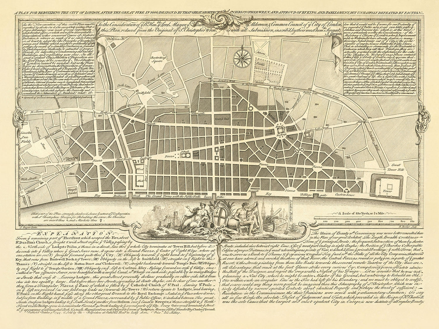
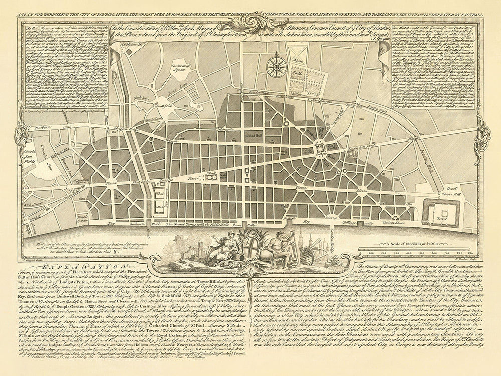


Old Map of London, 'A Plan for Rebuilding After The Great Fire' by Gwynn, 1749: St. Paul's, Monument, London Bridge
20% off 2 — 33% off 3
Add any two eligible items to your bag to receive 20% off. Add a third and it will be complimentary (equivalent to 33% off when purchasing three).
No code needed — the offer applies automatically at checkout.
Valid on all standard maps and fine art prints. You can mix and match any designs.
If you’d like to ship items to multiple addresses, please contact us before placing your order.
Custom and bespoke commissions are excluded.
Contact us if you have any questions
- All taxes and duties included
- Handmade & dispatched in 1-2 days
-
Complimentary gifting & design advice
ⓘ
Complimentary gifting & design advice
Available almost 24/7 on WhatsApp and email — we usually reply within minutes. We can help you:
- Choose a perfectly personalised gift
- Send a digital gift preview to the recipient
- Pick the ideal size for your wall
- Select the right finish and frame
Quick, friendly advice so you can order with confidence.
For last minute gifts, consider buying a digital gift card. We have over 5,000 maps and art prints to choose from.
-
90-day returns & 5-year guarantee
ⓘ
90-day returns & 5-year guarantee
Products can be returned within 90 days for a full refund, or exchange for another product.
We are also proud to offer a 5-year quality guarantee on our maps and art, covering defects in materials or workmanship under normal use.
For personalised and custom made items, we may offer you store credit or a non-expiring gift card, as we cannot resell personalised orders.
If you have any questions, get in touch. For more information, see our full returns & exchanges policy.

This is a museum-grade archival print from the original 1749 map — restored in our workshop and made to order on 220gsm archival matte paper or 400gsm artist's cotton canvas with pigment inks.
Professional framing & free personalisation available.
1. Choose a size
2. Frame & personalise your map
Make your map unique with framing, hand-drawn customisation, vintage ageing, pop art text, unique 3D styling and more.


Gift message & custom finish

If you want to add a gift message, or a finish (jigsaw, aluminium board, etc.) that is not available here, please request it in the "order note" when you check out.
Every order is custom made, so if you need the size adjusted slightly, or printed on an unusual material, just let us know. We've done thousands of custom orders over the years, so there's (almost) nothing we can't manage.
You can also contact us before you order, if you prefer!

- Handmade locally. No import duty or tax
- FREE worldwide delivery
- 90-day returns & 5-year product guarantee
- Questions? WhatsApp me any time
Own a piece of history
7,000+ 5 star reviews


Embark on a journey through time with the illustrious "A Plan For Rebuilding The City of London After The Great Fire in 1666; Design'd By That Great Architect Sr. Christopher Wren; and Approv'd of By King and Parliament, But Unhappily Defeated By Faction." This thematic map, crafted by the renowned surveyor and mapmaker John Gwynn in 1749, presents a visionary proposal by Sir Christopher Wren, one of history's most celebrated architects. Wren's ambitious plan, though never realized, aimed to transform the City of London in the aftermath of the devastating Great Fire of 1666. This map not only showcases the proposed new layout of streets and buildings but also serves as a window into the early concepts of city planning and the grandeur that London could have embraced.
John Gwynn, an eminent figure in 18th-century London for his cartographic prowess, offers through this map a glimpse into what could have been an architectural renaissance for the city. The map details the layout of proposed streets, parks, and public squares, echoing the classical influences that Wren admired during his studies in Paris and Rome. Among the notable features are the envisioned landmarks such as the Cathedral Church of St. Paul and The Monument, alongside the strategic placement of bridges spanning the River Thames, from the Tower Bridge to the Kew Bridge, indicating a thorough reimagining of London's urban landscape.
The River Thames, a lifeline for the city, is prominently featured, alongside Wren's proposal for a Thameside quay stretching from Bridewell to the Tower. This ambitious plan aimed to replace the haphazard wooden structures with orderly warehouses, showcasing a blend of functionality and aesthetic appeal. The map also highlights significant neighborhoods such as Westminster, Southwark, and Chelsea, and vast green spaces like St. James's Park and Hyde Park, illustrating a city that balances the bustle of urban life with the tranquility of nature.
Delving deeper into the map, one discovers the intricate network of streets that were to define the new London. From the bustling Cheapside to the serene Lincoln's Inn Fields, each road was a thread in the tapestry of Wren's vision. The shading on the map indicates the areas most affected by the Great Fire, providing a stark reminder of the city's resilience and the transformative power of architecture. This map is not merely a cartographic document; it is a testament to the undying spirit of London and the bold dreams that shape our urban landscapes.
This map stands as one of the rarest and most fascinating artifacts of Christopher Wren's architectural legacy, a fine example of what could have been a defining moment in the history of city planning. With a dedication from John Gwynn to the Lord Mayor and the City of London, and enriched with detailed notes and an explanation of Wren's proposal, this map is a treasure trove of historical and architectural insights. It offers not just a vision of London reborn from the ashes of the Great Fire but a reflection on the paths not taken, the plans that remain on paper, yet forever alter our understanding of what a city can aspire to be.
Streets and roads on this map
- Aldersgate
- Aldgate
- Bishopsgate
- Broad Street
- Chancery Lane
- Cheapside
- Chick Lane
- Clerkenwell
- Cornhill
- Cripplegate
- Cursitors Alley
- Dowgate
- Fetter Lane
- Fleet Bridge
- Fleet Street
- Gracechurch Street
- Great Tower Hill
- Hatton Street
- Holborn
- Holborn Bridge
- Leadenhall Street
- Lime Street
- Lincoln's Inn Fields
- Lombard Street
- Ludgate Hill
- Ludgate Piazza
- Mark Lane
- Newgate Street
- Oxford Street
- Paternoster Row
- Piccadilly
- Queen Street
- Royal Exchange
- St. Paul's Churchyard
- St. Paul's Piazza
- Shoe Lane
- Smithfield
- Snow Hill
- Temple Bar
- Thames Street
- Tower Hill
- Tower Street
- Wood Street
Notable Features & Landmarks
- The Cathedral Church of St. Paul
- The Monument
- The Tower of London
- The Royal Exchange
- The Custom House
- The Post Office
- The Guildhall
- The Mansion House
- The Bank of England
- The Royal Mint
- The London Bridge
Historical and design context
- The map is titled "A Plan For Rebuilding The City of London After The Great Fire in 1666; Design'd By That Great Architect Sr. Christopher Wren; and Approv'd of By King and Parliament, But Unhappily Defeated By Faction."
- Created by John Gwynn in 1749.
- John Gwynn was a surveyor and mapmaker known for his maps of London.
- Shows the proposed plan for rebuilding the City of London after the Great Fire of 1666.
- Designed by Sir Christopher Wren, a prominent architect of the time.
- Wren's plan was never implemented but is considered an important example of early city planning.
- The map shows the layout of the proposed new streets and buildings, as well as the location of public spaces such as parks and squares.
- Includes a key that explains the symbols used on the map.
- A valuable historical document providing insight into the early history of city planning in London.
- One of the rarest of Christopher Wren's proposed plans for rebuilding London.
- Fine reduced example of Christopher Wren's plan, engraved by Edward Rooker.
- Includes two panels with notes on Wren's proposal and an explanation to the plan.
- The shading indicates the area destroyed in the Great Fire.
- Wren was a Professor of Astronomy at Oxford with an interest in the science of architecture.
- The narrow streets that had helped spread the fires have been replaced by monumental avenues radiating from piazzas in the plan.
- Wren's classical buildings and formal street plans were influenced by his studies in Paris and Rome.
- He also proposed constructing a Thameside quay from Bridewell to the Tower.
Please double check the images to make sure that a specific town or place is shown on this map. You can also get in touch and ask us to check the map for you.
This map looks great at every size, but I always recommend going for a larger size if you have space. That way you can easily make out all of the details.
This map looks amazing at sizes all the way up to 50in (125cm). If you are looking for a larger map, please get in touch.
The model in the listing images is holding the 18x24in (45x60cm) version of this map.
The fifth listing image shows an example of my map personalisation service.
If you’re looking for something slightly different, check out my collection of the best old maps to see if something else catches your eye.
Please contact me to check if a certain location, landmark or feature is shown on this map.
This would make a wonderful birthday, Christmas, Father's Day, work leaving, anniversary or housewarming gift for someone from the areas covered by this map.
This map is available as a giclée print on acid free archival matte paper, or you can buy it framed. The frame is a nice, simple black frame that suits most aesthetics. Please get in touch if you'd like a different frame colour or material. My frames are glazed with super-clear museum-grade acrylic (perspex/acrylite), which is significantly less reflective than glass, safer, and will always arrive in perfect condition.
This map is also available as a float framed canvas, sometimes known as a shadow gap framed canvas or canvas floater. The map is printed on artist's cotton canvas and then stretched over a handmade box frame. We then "float" the canvas inside a wooden frame, which is available in a range of colours (black, dark brown, oak, antique gold and white). This is a wonderful way to present a map without glazing in front. See some examples of float framed canvas maps and explore the differences between my different finishes.
For something truly unique, this map is also available in "Unique 3D", our trademarked process that dramatically transforms the map so that it has a wonderful sense of depth. We combine the original map with detailed topography and elevation data, so that mountains and the terrain really "pop". For more info and examples of 3D maps, check my Unique 3D page.
For most orders, delivery time is about 3 working days. Personalised and customised products take longer, as I have to do the personalisation and send it to you for approval, which usually takes 1 or 2 days.
Please note that very large framed orders usually take longer to make and deliver.
If you need your order to arrive by a certain date, please contact me before you order so that we can find the best way of making sure you get your order in time.
I print and frame maps and artwork in 23 countries around the world. This means your order will be made locally, which cuts down on delivery time and ensures that it won't be damaged during delivery. You'll never pay customs or import duty, and we'll put less CO2 into the air.
All of my maps and art prints are well packaged and sent in a rugged tube if unframed, or surrounded by foam if framed.
I try to send out all orders within 1 or 2 days of receiving your order, though some products (like face masks, mugs and tote bags) can take longer to make.
If you select Express Delivery at checkout your order we will prioritise your order and send it out by 1-day courier (Fedex, DHL, UPS, Parcelforce).
Next Day delivery is also available in some countries (US, UK, Singapore, UAE) but please try to order early in the day so that we can get it sent out on time.
My standard frame is a gallery style black ash hardwood frame. It is simple and quite modern looking. My standard frame is around 20mm (0.8in) wide.
I use super-clear acrylic (perspex/acrylite) for the frame glass. It's lighter and safer than glass - and it looks better, as the reflectivity is lower.
Six standard frame colours are available for free (black, dark brown, dark grey, oak, white and antique gold). Custom framing and mounting/matting is available if you're looking for something else.
Most maps, art and illustrations are also available as a framed canvas. We use matte (not shiny) cotton canvas, stretch it over a sustainably sourced box wood frame, and then 'float' the piece within a wood frame. The end result is quite beautiful, and there's no glazing to get in the way.
All frames are provided "ready to hang", with either a string or brackets on the back. Very large frames will have heavy duty hanging plates and/or a mounting baton. If you have any questions, please get in touch.
See some examples of my framed maps and framed canvas maps.
Alternatively, I can also supply old maps and artwork on canvas, foam board, cotton rag and other materials.
If you want to frame your map or artwork yourself, please read my size guide first.
My maps are extremely high quality reproductions of original maps.
I source original, rare maps from libraries, auction houses and private collections around the world, restore them at my London workshop, and then use specialist giclée inks and printers to create beautiful maps that look even better than the original.
My maps are printed on acid-free archival matte (not glossy) paper that feels very high quality and almost like card. In technical terms the paper weight/thickness is 10mil/200gsm. It's perfect for framing.
I print with Epson ultrachrome giclée UV fade resistant pigment inks - some of the best inks you can find.
I can also make maps on canvas, cotton rag and other exotic materials.
Learn more about The Unique Maps Co.
Map personalisation
If you're looking for the perfect anniversary or housewarming gift, I can personalise your map to make it truly unique. For example, I can add a short message, or highlight an important location, or add your family's coat of arms.
The options are almost infinite. Please see my map personalisation page for some wonderful examples of what's possible.
To order a personalised map, select "personalise your map" before adding it to your basket.
Get in touch if you're looking for more complex customisations and personalisations.
Map ageing
I have been asked hundreds of times over the years by customers if they could buy a map that looks even older.
Well, now you can, by selecting Aged before you add a map to your basket.
All the product photos you see on this page show the map in its Original form. This is what the map looks like today.
If you select Aged, I will age your map by hand, using a special and unique process developed through years of studying old maps, talking to researchers to understand the chemistry of aging paper, and of course... lots of practice!
If you're unsure, stick to the Original colour of the map. If you want something a bit darker and older looking, go for Aged.
If you are not happy with your order for any reason, contact me and I'll get it fixed ASAP, free of charge. Please see my returns and refund policy for more information.
I am very confident you will like your restored map or art print. I have been doing this since 1984. I'm a 5-star Etsy seller. I have sold tens of thousands of maps and art prints and have over 5,000 real 5-star reviews. My work has been featured in interior design magazines, on the BBC, and on the walls of dozens of 5-star hotels.
I use a unique process to restore maps and artwork that is massively time consuming and labour intensive. Hunting down the original maps and illustrations can take months. I use state of the art and eye-wateringly expensive technology to scan and restore them. As a result, I guarantee my maps and art prints are a cut above the rest. I stand by my products and will always make sure you're 100% happy with what you receive.
Almost all of my maps and art prints look amazing at large sizes (200cm, 6.5ft+) and I can frame and deliver them to you as well, via special oversized courier. Contact me to discuss your specific needs.
Or try searching for something!


