


Old "Stranger's Guide" Map of London by Young, 1877: Pictorial "Grand Tour" Tourist Landmark Map
- All taxes and duties included
- Handmade & dispatched in 1-2 days
-
90 day money back guarantee
ⓘ
90 days to return and refund
Products can be returned within 90 days for a full refund, or exchange for another product.
For personalised and custom made items, we may offer you store credit or a non-expiring gift card, as we cannot resell personalised orders.
If you have any questions, get in touch. For more information, see our full returns & exchanges policy.

My maps are rare, museum-grade, restored old maps sourced from libraries, auction houses and private collections across the globe.
Framing & free personalisation available
1. Select your size
2. Frame & personalise your map
Make your map unique with framing, hand-drawn customisation, vintage ageing, pop art text, unique 3D styling and moreGift message & custom finish

If you want to add a gift message, or a finish (jigsaw, aluminium board, etc.) that is not available here, please request it in the "order note" when you check out.
Every order is custom made, so if you need the size adjusted slightly, or printed on an unusual material, just let us know. We've done thousands of custom orders over the years, so there's (almost) nothing we can't manage.
You can also contact us before you order, if you prefer!

- Handmade locally. No import duty or tax
- FREE Delivery. Arrives in 2-3 days
- Love it or your money back
- Questions? WhatsApp me any time
Own a piece of history
5,000+ 5 star reviews


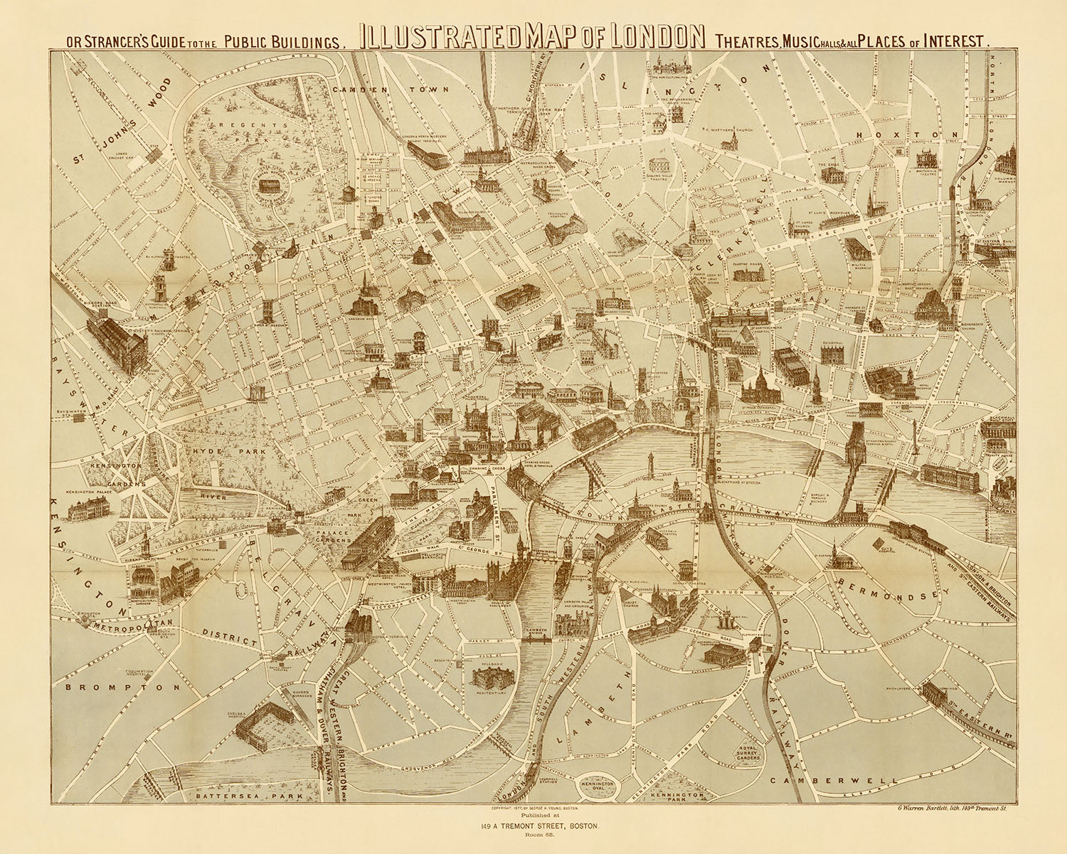
Embark on a captivating journey through the heart of Victorian London with the illustrious "Illustrated Map of London, or, Stranger's Guide to the Public Buildings, Theatres, Music Halls, & and all Places of Interest." Crafted with meticulous detail by the esteemed mapmaker George H. Young in 1877, this masterpiece stands as a testament to the grandeur and vibrancy of London during a pivotal era. Unlike the common cartographic styles of the time, this map draws inspiration from the Parisian 'Grand Tour' maps, making it a rare and fascinating portrayal of London. It serves not only as a navigational aid but as a window into the past, showcasing the city's architectural marvels and bustling streets as they stood over a century ago.
The map's geographic focus encompasses an area rich in history and culture, stretching from Kensington Palace in the west to the Tower of London in the east, and from Islington Green in the north to Kennington Oval and Park in the south. This expanse includes some of London's most iconic neighborhoods such as Kensington, Chelsea, and Covent Garden, each illustrated with an eye for detail that brings the Victorian era to life. The inclusion of landmarks like the Royal Courts of Justice at its center underscores the map's emphasis on places of legal, cultural, and historical significance, offering a comprehensive guide to the city's heart and soul.
Notably, the map is adorned with pictorial representations of major landmarks that define London's skyline, including the Houses of Parliament, St. Paul's Cathedral, and the Tower of London. These illustrations are more than mere adornments; they are intricately detailed artworks that capture the architectural essence of each building, inviting viewers to appreciate the craftsmanship and heritage of London's most cherished monuments. This artistic approach not only enhances the map's aesthetic appeal but also serves as an educational tool, providing insights into the architectural styles and urban development of the time.
The map's utility is further enriched by its detailed coverage of London's vast network of streets, roads, and waterways. From the bustling thoroughfares of Oxford Street and Piccadilly to the serene flow of the River Thames, the map meticulously charts the city's complex geography. This includes significant green spaces such as Hyde Park and Regent's Park, offering a glimpse into the urban planning and recreational areas that have long provided Londoners with respite from city life. Such comprehensive detail makes the map an invaluable resource for historians, cartographers, and anyone fascinated by London's urban evolution.
In conclusion, George H. Young's "Illustrated Map of London" is more than a mere cartographic document; it is a luxurious artifact that captures the essence of Victorian London in all its complexity and grandeur. Its unique blend of artistic illustration and geographical precision makes it an exceptional piece of history, offering a detailed and engaging portrayal of the city's landmarks, neighborhoods, and streets. For collectors, historians, and aficionados of London, this map is not just a piece of art; it is a portal to the past, inviting exploration and discovery of the world's most iconic city as it was in 1877.
Streets and roads on this map
- Aldersgate Street
- Bayswater Road
- Bishopsgate Street
- Blackfriars Road
- Bow Street
- Brompton Road
- Chancery Lane
- Cheapside
- Charing Cross Road
- Commercial Road
- Cornhill
- Coventry Street
- Edgware Road
- Euston Road
- Fleet Street
- Gray's Inn Road
- Great Dover Street
- Great Eastern Street
- Great Portland Street
- Great Russell Street
- Grosvenor Place
- Holborn
- Holborn Viaduct
- Hyde Park Corner
- Kensington Gore
- Kensington Road
- King's Cross Road
- Kingsland Road
- Leadenhall Street
- Long Acre
- Ludgate Hill
- Marylebone Lane
- Oxford Street
- Park Lane
- Piccadilly
- Regent Street
- St. Giles High Street
- St. James's Street
- St. John Street
- Strand
- Tottenham Court Road
- Victoria Street
- Watling Street
- Whitechapel Road
Notable Features & Landmarks
- The Serpentine
- Hyde Park
- Kensington Gardens
- Green Park
- St. James's Park
- Regent's Park
- Primrose Hill
- Hampstead Heath
- The River Thames
- The Houses of Parliament
- St. Paul's Cathedral
- The Tower of London
- The British Museum
- The Royal Albert Hall
- The Royal Opera House
- The Drury Lane Theatre
- The Covent Garden Theatre
- The Lyceum Theatre
- The Haymarket Theatre
- The Piccadilly Theatre
- The Strand Theatre
- The Adelphi Theatre
- The Vaudeville Theatre
- The Olympic Theatre
- The Princess's Theatre
- The Globe Theatre
- The Sadler's Wells Theatre
- The Old Vic Theatre
- The Crystal Palace
Historical and design context
- Title: Illustrated map of London, or, Stranger's guide to the public buildings, theatres, music halls, & and all places of interest
- Date: 1877
- Mapmaker/Publisher: George H. Young
- The map is modeled after similar maps of Paris that were issued in the late 19th to the early 20th century for the 'Grand Tour' tourist market.
- The style is quite unusual for a London map.
- Almost every major landmark or train station that had been built by 1877 is illustrated on this map.
- Design/Style: Pictorial
- Historical significance: This map is an interesting example of the 'Grand Tour' style of map, which was popular in the late 19th and early 20th centuries.
Please double check the images to make sure that a specific town or place is shown on this map. You can also get in touch and ask us to check the map for you.
This map looks great at every size, but I always recommend going for a larger size if you have space. That way you can easily make out all of the details.
This map looks amazing at sizes all the way up to 50in (125cm). If you are looking for a larger map, please get in touch.
Please note: the labels on this map are hard to read if you order a map that is 16in (40cm) or smaller. The map is still very attractive, but if you would like to read the map easily, please buy a larger size.
The model in the listing images is holding the 16x20in (40x50cm) version of this map.
The fifth listing image shows an example of my map personalisation service.
If you’re looking for something slightly different, check out my collection of the best old maps to see if something else catches your eye.
Please contact me to check if a certain location, landmark or feature is shown on this map.
This would make a wonderful birthday, Christmas, Father's Day, work leaving, anniversary or housewarming gift for someone from the areas covered by this map.
This map is available as a giclée print on acid free archival matte paper, or you can buy it framed. The frame is a nice, simple black frame that suits most aesthetics. Please get in touch if you'd like a different frame colour or material. My frames are glazed with super-clear museum-grade acrylic (perspex/acrylite), which is significantly less reflective than glass, safer, and will always arrive in perfect condition.
This map is also available as a float framed canvas, sometimes known as a shadow gap framed canvas or canvas floater. The map is printed on artist's cotton canvas and then stretched over a handmade box frame. We then "float" the canvas inside a wooden frame, which is available in a range of colours (black, dark brown, oak, antique gold and white). This is a wonderful way to present a map without glazing in front. See some examples of float framed canvas maps and explore the differences between my different finishes.
For something truly unique, this map is also available in "Unique 3D", our trademarked process that dramatically transforms the map so that it has a wonderful sense of depth. We combine the original map with detailed topography and elevation data, so that mountains and the terrain really "pop". For more info and examples of 3D maps, check my Unique 3D page.
For most orders, delivery time is about 3 working days. Personalised and customised products take longer, as I have to do the personalisation and send it to you for approval, which usually takes 1 or 2 days.
Please note that very large framed orders usually take longer to make and deliver.
If you need your order to arrive by a certain date, please contact me before you order so that we can find the best way of making sure you get your order in time.
I print and frame maps and artwork in 23 countries around the world. This means your order will be made locally, which cuts down on delivery time and ensures that it won't be damaged during delivery. You'll never pay customs or import duty, and we'll put less CO2 into the air.
All of my maps and art prints are well packaged and sent in a rugged tube if unframed, or surrounded by foam if framed.
I try to send out all orders within 1 or 2 days of receiving your order, though some products (like face masks, mugs and tote bags) can take longer to make.
If you select Express Delivery at checkout your order we will prioritise your order and send it out by 1-day courier (Fedex, DHL, UPS, Parcelforce).
Next Day delivery is also available in some countries (US, UK, Singapore, UAE) but please try to order early in the day so that we can get it sent out on time.
My standard frame is a gallery style black ash hardwood frame. It is simple and quite modern looking. My standard frame is around 20mm (0.8in) wide.
I use super-clear acrylic (perspex/acrylite) for the frame glass. It's lighter and safer than glass - and it looks better, as the reflectivity is lower.
Six standard frame colours are available for free (black, dark brown, dark grey, oak, white and antique gold). Custom framing and mounting/matting is available if you're looking for something else.
Most maps, art and illustrations are also available as a framed canvas. We use matte (not shiny) cotton canvas, stretch it over a sustainably sourced box wood frame, and then 'float' the piece within a wood frame. The end result is quite beautiful, and there's no glazing to get in the way.
All frames are provided "ready to hang", with either a string or brackets on the back. Very large frames will have heavy duty hanging plates and/or a mounting baton. If you have any questions, please get in touch.
See some examples of my framed maps and framed canvas maps.
Alternatively, I can also supply old maps and artwork on canvas, foam board, cotton rag and other materials.
If you want to frame your map or artwork yourself, please read my size guide first.
My maps are extremely high quality reproductions of original maps.
I source original, rare maps from libraries, auction houses and private collections around the world, restore them at my London workshop, and then use specialist giclée inks and printers to create beautiful maps that look even better than the original.
My maps are printed on acid-free archival matte (not glossy) paper that feels very high quality and almost like card. In technical terms the paper weight/thickness is 10mil/200gsm. It's perfect for framing.
I print with Epson ultrachrome giclée UV fade resistant pigment inks - some of the best inks you can find.
I can also make maps on canvas, cotton rag and other exotic materials.
Learn more about The Unique Maps Co.
Map personalisation
If you're looking for the perfect anniversary or housewarming gift, I can personalise your map to make it truly unique. For example, I can add a short message, or highlight an important location, or add your family's coat of arms.
The options are almost infinite. Please see my map personalisation page for some wonderful examples of what's possible.
To order a personalised map, select "personalise your map" before adding it to your basket.
Get in touch if you're looking for more complex customisations and personalisations.
Map ageing
I have been asked hundreds of times over the years by customers if they could buy a map that looks even older.
Well, now you can, by selecting Aged before you add a map to your basket.
All the product photos you see on this page show the map in its Original form. This is what the map looks like today.
If you select Aged, I will age your map by hand, using a special and unique process developed through years of studying old maps, talking to researchers to understand the chemistry of aging paper, and of course... lots of practice!
If you're unsure, stick to the Original colour of the map. If you want something a bit darker and older looking, go for Aged.
If you are not happy with your order for any reason, contact me and I'll get it fixed ASAP, free of charge. Please see my returns and refund policy for more information.
I am very confident you will like your restored map or art print. I have been doing this since 1984. I'm a 5-star Etsy seller. I have sold tens of thousands of maps and art prints and have over 5,000 real 5-star reviews. My work has been featured in interior design magazines, on the BBC, and on the walls of dozens of 5-star hotels.
I use a unique process to restore maps and artwork that is massively time consuming and labour intensive. Hunting down the original maps and illustrations can take months. I use state of the art and eye-wateringly expensive technology to scan and restore them. As a result, I guarantee my maps and art prints are a cut above the rest. I stand by my products and will always make sure you're 100% happy with what you receive.
Almost all of my maps and art prints look amazing at large sizes (200cm, 6.5ft+) and I can frame and deliver them to you as well, via special oversized courier. Contact me to discuss your specific needs.
Or try searching for something!


