

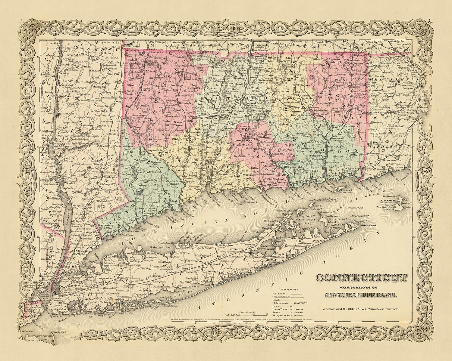

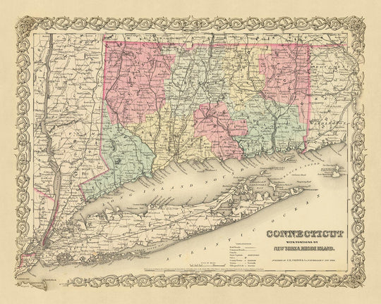


Old Map of Connecticut & Long Island by Colton, 1855: New Haven, Hartford, Bridgeport, Stamford, and New London
- All taxes and duties included
- Handmade & dispatched in 1-2 days
-
90 day money back guarantee
ⓘ
90 days to return and refund
Products can be returned within 90 days for a full refund, or exchange for another product.
For personalised and custom made items, we may offer you store credit or a non-expiring gift card, as we cannot resell personalised orders.
If you have any questions, get in touch. For more information, see our full returns & exchanges policy.

My maps are rare, museum-grade, restored old maps sourced from libraries, auction houses and private collections across the globe.
Framing & free personalisation available
1. Select your size
2. Frame & personalise your map
Make your map unique with framing, hand-drawn customisation, vintage ageing, pop art text, unique 3D styling and moreGift message & custom finish

If you want to add a gift message, or a finish (jigsaw, aluminium board, etc.) that is not available here, please request it in the "order note" when you check out.
Every order is custom made, so if you need the size adjusted slightly, or printed on an unusual material, just let us know. We've done thousands of custom orders over the years, so there's (almost) nothing we can't manage.
You can also contact us before you order, if you prefer!
Order by 10am tomorrow for free Christmas delivery

- Handmade locally. No import duty or tax
- FREE Delivery. Arrives in 2-3 days
- Love it or your money back
- Questions? WhatsApp me any time
Own a piece of history
5,000+ 5 star reviews


Step back in time with this extraordinary map of Connecticut and Long Island from 1855, a period early in the history of the United States. Published by J. H. Colton, a mapmaker renowned for his precision and craftsmanship, this map is a significant artifact that provides a unique glimpse into a past where many of today's settlements were yet to be founded. The landscape, names, and borders have undergone significant transformations over the past 150 years, and this map serves as a remarkable testament to these changes.
The map is a masterpiece from Colton, who is widely recognized as the finest American mapmaker of his era. His attention to detail and dedication to his craft are evident in the intricacies of this map. This piece not only serves as a historical record but also as a work of art, making it a prized possession for collectors and history enthusiasts alike. The rich details and historical significance of this map make it a fascinating snapshot of the past and a timeless piece of cartographic artistry.
Connecticut
- New Haven (1638) - Originally known as Quinnipiac, it's home to Yale University, one of the oldest and most prestigious institutions of higher education in the U.S.
- Hartford (1635) - Known as the "Insurance Capital of the World," it was once home to Mark Twain.
- Bridgeport (1821) - The most populous city in the state, it's known for its public park system.
- Stamford (1641) - Known as Rippowam by the Native American inhabitants, it's now a major business hub.
- New London (1646) - Once a world-leading whaling port, it's now home to the U.S. Coast Guard Academy.
- Norwich (1659) - Known as "The Rose of New England," it was a major center for trade and manufacturing.
- Greenwich (1640) - Known for its affluent communities and as the gateway to New England.
- Waterbury (1674) - Known as the "Brass City" for its significant industrial past.
- Danbury (1687) - Known for its hat-making industry, giving it the nickname "Hat City."
- Middletown (1650) - A major port from its founding until the decline of maritime industries in the state.
Long Island
- Brooklyn (1646) - Originally known as Breuckelen, it's now one of the five boroughs of New York City.
- Hempstead (1644) - One of the oldest towns in New York State, it played a significant role in the American Revolution.
- Southampton (1640) - Known for its historic and wealthy residential section, the Hamptons.
- Huntington (1653) - Known for its picturesque downtown area and high-quality schools.
- Oyster Bay (1653) - Known for its oyster production in the 19th and 20th centuries.
- Smithtown (1665) - Known for its preserved and working farms, as well as its rich history.
- Riverhead (1792) - Known as the agricultural apex of Long Island.
- Islip (1683) - Known for its waterfront communities and recreational fishing.
- Babylon (1872) - Known for its popular outdoor attractions and historic downtown.
- Glen Cove (1668) - Known for its significant industry during the 19th century.
Indian Tribes
- Pequot - Once one of the most powerful tribes in southern New England.
- Mohegan - Known for their independence and the establishment of one of the first Indian reservations in America.
- Niantic - Known for their alliance with the Pequot against the Narragansett and Mohegan tribes.
- Paugussett - Known for their struggle to maintain their tribal lands against colonial expansion.
Notable Natural Phenomena
- Long Island Sound - A tidal estuary of the Atlantic Ocean, lying between eastern Long Island and the rest of Connecticut.
- Connecticut River - The longest river in the New England region, known for its beauty and recreational activities.
- Thames River - Known for its historic significance as a transportation route.
- Housatonic River - Known for its outdoor recreational opportunities, including fishing, boating, and hiking along its banks.
Historical Events (1810-1855)
- War of 1812 (1812-1815) - Several naval battles took place off the coast of Connecticut.
- Industrialization (mid-1800s) - Connecticut and Long Island experienced significant industrial growth, with factories and mills springing up in many towns and cities.
Please double check the images to make sure that a specific town or place is shown on this map. You can also get in touch and ask us to check the map for you.
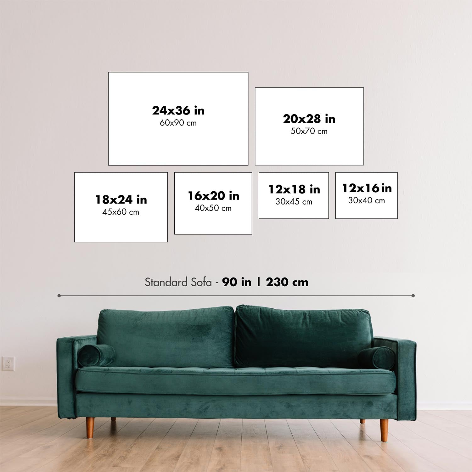
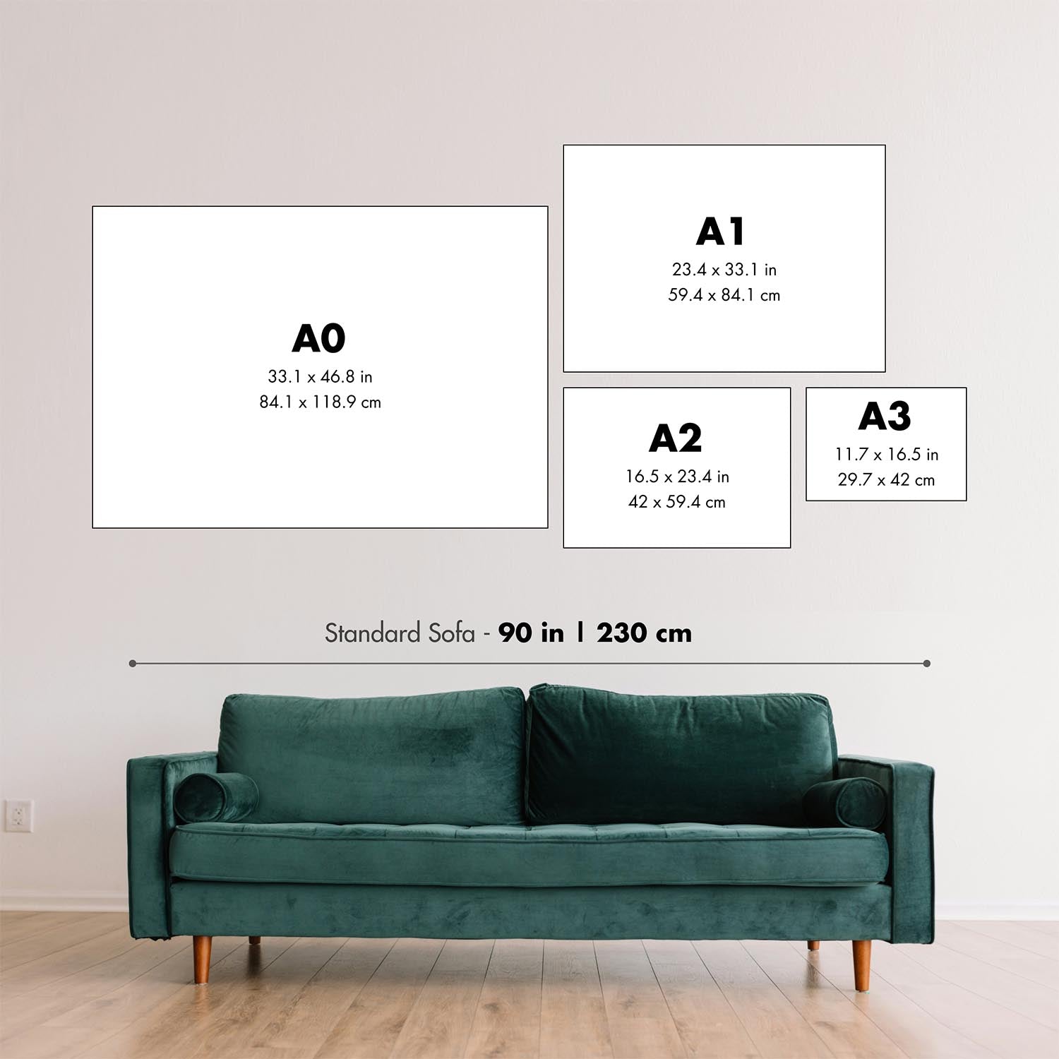
This map looks great at all sizes: 12x16in (30.5x41cm), 16x20in (40.5x51cm), 18x24in (45.5x61cm), 24x30in (61x76cm), 32x40in (81.5x102cm), 40x50in (102x127cm), 48x60in (122x153cm) and 56x70in (142x178cm), but it looks even better when printed large.
I can create beautiful, large prints of this map up to 70in (178cm). Please get in touch if you're looking for larger, customised or different framing options.
The model in the listing images is holding the 16x20in (40.5x51cm) version of this map.
The fifth listing image shows an example of my map personalisation service.
If you’re looking for something slightly different, check out my main collection of USA and North America maps.
Please contact me to check if a certain location, landmark or feature is shown on this map.
This would make a wonderful birthday, Christmas, Father's Day, work leaving, anniversary or housewarming gift for someone from the areas covered by this map.
This map is available as a giclée print on acid free archival matte paper, or you can buy it framed. The frame is a nice, simple black frame that suits most aesthetics. Please get in touch if you'd like a different frame colour or material. My frames are glazed with super-clear museum-grade acrylic (perspex/acrylite), which is significantly less reflective than glass, safer, and will always arrive in perfect condition.
This map is also available as a float framed canvas, sometimes known as a shadow gap framed canvas or canvas floater. The map is printed on artist's cotton canvas and then stretched over a handmade box frame. We then "float" the canvas inside a wooden frame, which is available in a range of colours (black, dark brown, oak, antique gold and white). This is a wonderful way to present a map without glazing in front. See some examples of float framed canvas maps and explore the differences between my different finishes.
For something truly unique, this map is also available in "Unique 3D", our trademarked process that dramatically transforms the map so that it has a wonderful sense of depth. We combine the original map with detailed topography and elevation data, so that mountains and the terrain really "pop". For more info and examples of 3D maps, check my Unique 3D page.
For most orders, delivery time is about 3 working days. Personalised and customised products take longer, as I have to do the personalisation and send it to you for approval, which usually takes 1 or 2 days.
Please note that very large framed orders usually take longer to make and deliver.
If you need your order to arrive by a certain date, please contact me before you order so that we can find the best way of making sure you get your order in time.
I print and frame maps and artwork in 23 countries around the world. This means your order will be made locally, which cuts down on delivery time and ensures that it won't be damaged during delivery. You'll never pay customs or import duty, and we'll put less CO2 into the air.
All of my maps and art prints are well packaged and sent in a rugged tube if unframed, or surrounded by foam if framed.
I try to send out all orders within 1 or 2 days of receiving your order, though some products (like face masks, mugs and tote bags) can take longer to make.
If you select Express Delivery at checkout your order we will prioritise your order and send it out by 1-day courier (Fedex, DHL, UPS, Parcelforce).
Next Day delivery is also available in some countries (US, UK, Singapore, UAE) but please try to order early in the day so that we can get it sent out on time.
My standard frame is a gallery style black ash hardwood frame. It is simple and quite modern looking. My standard frame is around 20mm (0.8in) wide.
I use super-clear acrylic (perspex/acrylite) for the frame glass. It's lighter and safer than glass - and it looks better, as the reflectivity is lower.
Six standard frame colours are available for free (black, dark brown, dark grey, oak, white and antique gold). Custom framing and mounting/matting is available if you're looking for something else.
Most maps, art and illustrations are also available as a framed canvas. We use matte (not shiny) cotton canvas, stretch it over a sustainably sourced box wood frame, and then 'float' the piece within a wood frame. The end result is quite beautiful, and there's no glazing to get in the way.
All frames are provided "ready to hang", with either a string or brackets on the back. Very large frames will have heavy duty hanging plates and/or a mounting baton. If you have any questions, please get in touch.
See some examples of my framed maps and framed canvas maps.
Alternatively, I can also supply old maps and artwork on canvas, foam board, cotton rag and other materials.
If you want to frame your map or artwork yourself, please read my size guide first.
My maps are extremely high quality reproductions of original maps.
I source original, rare maps from libraries, auction houses and private collections around the world, restore them at my London workshop, and then use specialist giclée inks and printers to create beautiful maps that look even better than the original.
My maps are printed on acid-free archival matte (not glossy) paper that feels very high quality and almost like card. In technical terms the paper weight/thickness is 10mil/200gsm. It's perfect for framing.
I print with Epson ultrachrome giclée UV fade resistant pigment inks - some of the best inks you can find.
I can also make maps on canvas, cotton rag and other exotic materials.
Learn more about The Unique Maps Co.
Map personalisation
If you're looking for the perfect anniversary or housewarming gift, I can personalise your map to make it truly unique. For example, I can add a short message, or highlight an important location, or add your family's coat of arms.
The options are almost infinite. Please see my map personalisation page for some wonderful examples of what's possible.
To order a personalised map, select "personalise your map" before adding it to your basket.
Get in touch if you're looking for more complex customisations and personalisations.
Map ageing
I have been asked hundreds of times over the years by customers if they could buy a map that looks even older.
Well, now you can, by selecting Aged before you add a map to your basket.
All the product photos you see on this page show the map in its Original form. This is what the map looks like today.
If you select Aged, I will age your map by hand, using a special and unique process developed through years of studying old maps, talking to researchers to understand the chemistry of aging paper, and of course... lots of practice!
If you're unsure, stick to the Original colour of the map. If you want something a bit darker and older looking, go for Aged.
If you are not happy with your order for any reason, contact me and I'll get it fixed ASAP, free of charge. Please see my returns and refund policy for more information.
I am very confident you will like your restored map or art print. I have been doing this since 1984. I'm a 5-star Etsy seller. I have sold tens of thousands of maps and art prints and have over 5,000 real 5-star reviews. My work has been featured in interior design magazines, on the BBC, and on the walls of dozens of 5-star hotels.
I use a unique process to restore maps and artwork that is massively time consuming and labour intensive. Hunting down the original maps and illustrations can take months. I use state of the art and eye-wateringly expensive technology to scan and restore them. As a result, I guarantee my maps and art prints are a cut above the rest. I stand by my products and will always make sure you're 100% happy with what you receive.
Almost all of my maps and art prints look amazing at large sizes (200cm, 6.5ft+) and I can frame and deliver them to you as well, via special oversized courier. Contact me to discuss your specific needs.
Or try searching for something!


