

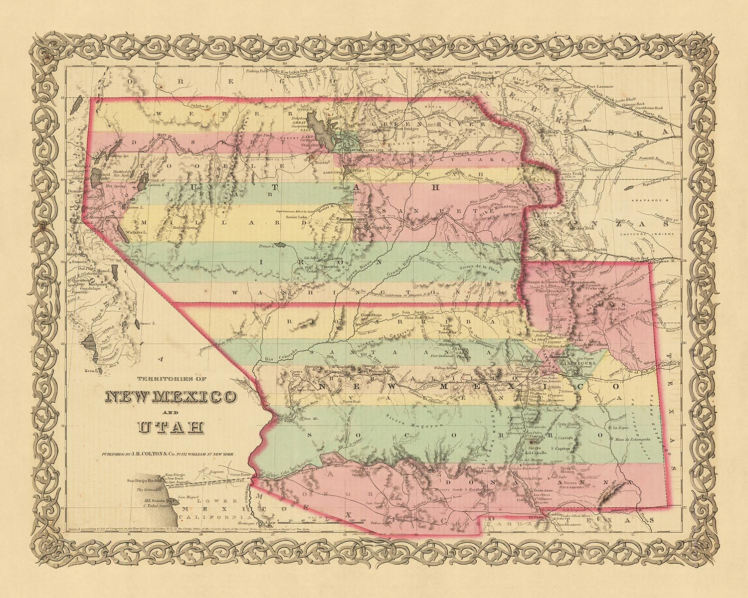

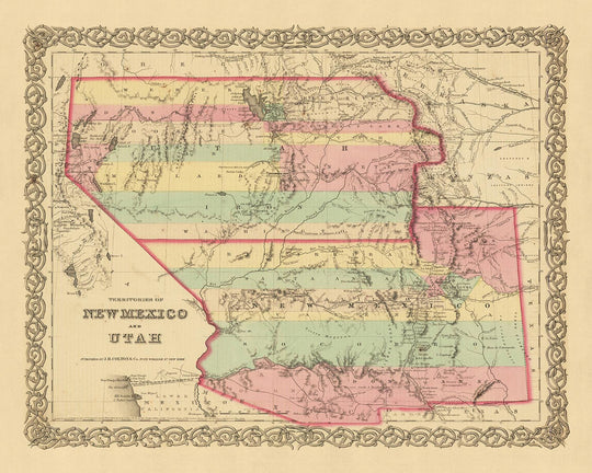


Old map of New Mexico & Utah by J.H. Colton, 1856: Santa Fe, Albuquerque, Provo, Salt Lake City, St. George
- All taxes and duties included
- Handmade & dispatched in 1-2 days
-
90 day money back guarantee
ⓘ
90 days to return and refund
Products can be returned within 90 days for a full refund, or exchange for another product.
For personalised and custom made items, we may offer you store credit or a non-expiring gift card, as we cannot resell personalised orders.
If you have any questions, get in touch. For more information, see our full returns & exchanges policy.

My maps are rare, museum-grade, restored old maps sourced from libraries, auction houses and private collections across the globe.
Framing & free personalisation available
1. Select your size
2. Frame & personalise your map
Make your map unique with framing, hand-drawn customisation, vintage ageing, pop art text, unique 3D styling and moreGift message & custom finish

If you want to add a gift message, or a finish (jigsaw, aluminium board, etc.) that is not available here, please request it in the "order note" when you check out.
Every order is custom made, so if you need the size adjusted slightly, or printed on an unusual material, just let us know. We've done thousands of custom orders over the years, so there's (almost) nothing we can't manage.
You can also contact us before you order, if you prefer!
Order by 10am tomorrow for free Christmas delivery

- Handmade locally. No import duty or tax
- FREE Delivery. Arrives in 2-3 days
- Love it or your money back
- Questions? WhatsApp me any time
Own a piece of history
5,000+ 5 star reviews


Journey back in time with this exquisite old map of New Mexico and Utah, meticulously crafted by J.H. Colton in 1856. Colton, widely regarded as the premier American mapmaker of his era, brings the rich history of these regions to life in stunning detail. This map serves as a snapshot of a pivotal moment in the early history of the United States, a time when many of the settlements we know today were yet to be founded, and the names and borders of the territories were in a state of flux.
This map offers a unique perspective on the evolution of the American West. In 1856, New Mexico and Utah were frontier territories, their landscapes largely uncharted and their populations sparse. The map reveals a world where the familiar blends with the unfamiliar, where towns and cities that are now household names coexist with settlements that have since faded into obscurity. It's a fascinating glimpse into the past, a testament to the enduring allure of these storied lands.
The map features five of the most notable settlements in New Mexico and Utah as of 1855: Santa Fe, Albuquerque, Provo, Salt Lake City, and St. George. These settlements, some of which have grown into bustling cities, serve as markers of the human imprint on these vast territories. Each one has its own story to tell, its own place in the rich tapestry of American history.
In Santa Fe, the oldest capital city in the United States, one can trace the echoes of Spanish colonial rule. Albuquerque, with its blend of Native American, Hispanic, and Anglo cultures, is a testament to the region's diverse heritage. Provo, nestled between the breathtaking Wasatch Range and Utah Lake, was a burgeoning Mormon settlement. Salt Lake City, the heart of the Mormon pioneer movement, was a beacon of hope and a symbol of resilience. And St. George, with its striking red cliffs, was a frontier outpost on the edge of the Mojave Desert.
This map by J.H. Colton is more than just a geographical representation of New Mexico and Utah in 1856. It's a piece of history, a window into a bygone era, and a testament to the enduring spirit of exploration and discovery. It's a reminder of how far we've come as a nation, and a tribute to the pioneers who charted the course of our shared history. This is an exceptional piece for any discerning collector, a true gem that will add a touch of elegance and historical intrigue to any setting.
New Mexico
- Santa Fe (1610) - Known as "La Villa Real de la Santa Fe de San Francisco," it is the oldest state capital in the United States.
- Albuquerque (1706) - Originally named "La Villa de Alburquerque," it's notable for its cultural blend of Native American, Hispanic, and Anglo influences.
- Las Cruces (1849) - Established during the California Gold Rush, it was a key stop on the Butterfield Overland Mail Route.
- Socorro (1598) - Originally named "Nuestra Señora de Perpetuo Socorro," it was a key settlement in the Spanish colonial era.
- Taos (1615) - Known for the historic Taos Pueblo, a UNESCO World Heritage Site.
- Bernalillo (1695) - Home to the Coronado Historic Site, where remnants of an ancient Indian pueblo were found.
- Los Lunas (1716) - Named after the Luna family, early Spanish settlers in the region.
- Las Vegas (1835) - Not to be confused with its namesake in Nevada, it was a key stop on the Santa Fe Trail.
- Mesilla (1848) - Known for the historic Mesilla Plaza, a key site in the Mexican-American War.
- Cimarron (1850) - A significant stop on the Santa Fe Trail and later a hub for the mining industry.
Utah
- Salt Lake City (1847) - Founded by Mormon pioneers and serves as the headquarters of The Church of Jesus Christ of Latter-day Saints.
- Provo (1849) - Home to Brigham Young University, one of the largest private higher education institutions in the U.S.
- Ogden (1846) - A major railway hub, known as "Junction City."
- Farmington (1847) - Originally settled by Mormon pioneers, it's the county seat of Davis County.
- Bountiful (1847) - Named after a city in the Book of Mormon, it was settled by Perrigrine Sessions, a notable Mormon pioneer.
- Manti (1849) - Known for the Manti Utah Temple, the third temple built by the Mormon Church.
- Parowan (1851) - Known as the "Mother Town of Southern Utah," many southern Utah towns were settled from Parowan.
- Springville (1850) - Named for the many freshwater springs in the area, it's home to the Springville Museum of Art.
- Fillmore (1851) - Named after President Millard Fillmore, it was once the capital of Utah Territory.
- Cedar City (1851) - Known as "Gateway to the National Parks" due to its proximity to several natural attractions.
Indian Tribes and Territories
- Navajo Nation - The largest land area assigned primarily to a Native American jurisdiction.
- Ute Indian Tribe - The tribe's Uintah and Ouray reservation is located in northeastern Utah.
- Pueblo Tribes - Known for their unique architecture and craftsmanship.
- Apache Tribes - Historically known for their strong warrior traditions.
Notable Natural Phenomena
- Rio Grande - One of the principal rivers in the southwest United States and northern Mexico.
- Great Salt Lake - The largest saltwater lake in the Western Hemisphere.
- Zion National Park - Noted for its sandstone cliffs and unique wildlife.
- Bryce Canyon - Known for its distinctive geological structures, called hoodoos.
- White Sands National Park - The world's largest gypsum dunefield.
Historical Events
- Mexican-American War (1846-1848) - Resulted in the U.S. acquiring a large portion of the present-day American Southwest, including New Mexico and Utah.
- Mormon Pioneer Exodus (1846-1857) - The migration of members of The Church of Jesus Christ of Latter-day Saints to the Salt Lake Valley.
- Compromise of 1850 - Admitted California as a free state and established Utah and New Mexico as territories with the question of slavery to be decided by popular sovereignty.
Please double check the images to make sure that a specific town or place is shown on this map. You can also get in touch and ask us to check the map for you.
This map looks great at all sizes: 12x16in (30.5x41cm), 16x20in (40.5x51cm), 18x24in (45.5x61cm), 24x30in (61x76cm), 32x40in (81.5x102cm), 40x50in (102x127cm), 48x60in (122x153cm) and 56x70in (142x178cm), but it looks even better when printed large.
I can create beautiful, large prints of this map up to 70in (178cm). Please get in touch if you're looking for larger, customised or different framing options.
The model in the listing images is holding the 16x20in (40.5x51cm) version of this map.
The fifth listing image shows an example of my map personalisation service.
If you’re looking for something slightly different, check out my main collection of USA and North America maps.
Please contact me to check if a certain location, landmark or feature is shown on this map.
This would make a wonderful birthday, Christmas, Father's Day, work leaving, anniversary or housewarming gift for someone from the areas covered by this map.
This map is available as a giclée print on acid free archival matte paper, or you can buy it framed. The frame is a nice, simple black frame that suits most aesthetics. Please get in touch if you'd like a different frame colour or material. My frames are glazed with super-clear museum-grade acrylic (perspex/acrylite), which is significantly less reflective than glass, safer, and will always arrive in perfect condition.
This map is also available as a float framed canvas, sometimes known as a shadow gap framed canvas or canvas floater. The map is printed on artist's cotton canvas and then stretched over a handmade box frame. We then "float" the canvas inside a wooden frame, which is available in a range of colours (black, dark brown, oak, antique gold and white). This is a wonderful way to present a map without glazing in front. See some examples of float framed canvas maps and explore the differences between my different finishes.
For something truly unique, this map is also available in "Unique 3D", our trademarked process that dramatically transforms the map so that it has a wonderful sense of depth. We combine the original map with detailed topography and elevation data, so that mountains and the terrain really "pop". For more info and examples of 3D maps, check my Unique 3D page.
For most orders, delivery time is about 3 working days. Personalised and customised products take longer, as I have to do the personalisation and send it to you for approval, which usually takes 1 or 2 days.
Please note that very large framed orders usually take longer to make and deliver.
If you need your order to arrive by a certain date, please contact me before you order so that we can find the best way of making sure you get your order in time.
I print and frame maps and artwork in 23 countries around the world. This means your order will be made locally, which cuts down on delivery time and ensures that it won't be damaged during delivery. You'll never pay customs or import duty, and we'll put less CO2 into the air.
All of my maps and art prints are well packaged and sent in a rugged tube if unframed, or surrounded by foam if framed.
I try to send out all orders within 1 or 2 days of receiving your order, though some products (like face masks, mugs and tote bags) can take longer to make.
If you select Express Delivery at checkout your order we will prioritise your order and send it out by 1-day courier (Fedex, DHL, UPS, Parcelforce).
Next Day delivery is also available in some countries (US, UK, Singapore, UAE) but please try to order early in the day so that we can get it sent out on time.
My standard frame is a gallery style black ash hardwood frame. It is simple and quite modern looking. My standard frame is around 20mm (0.8in) wide.
I use super-clear acrylic (perspex/acrylite) for the frame glass. It's lighter and safer than glass - and it looks better, as the reflectivity is lower.
Six standard frame colours are available for free (black, dark brown, dark grey, oak, white and antique gold). Custom framing and mounting/matting is available if you're looking for something else.
Most maps, art and illustrations are also available as a framed canvas. We use matte (not shiny) cotton canvas, stretch it over a sustainably sourced box wood frame, and then 'float' the piece within a wood frame. The end result is quite beautiful, and there's no glazing to get in the way.
All frames are provided "ready to hang", with either a string or brackets on the back. Very large frames will have heavy duty hanging plates and/or a mounting baton. If you have any questions, please get in touch.
See some examples of my framed maps and framed canvas maps.
Alternatively, I can also supply old maps and artwork on canvas, foam board, cotton rag and other materials.
If you want to frame your map or artwork yourself, please read my size guide first.
My maps are extremely high quality reproductions of original maps.
I source original, rare maps from libraries, auction houses and private collections around the world, restore them at my London workshop, and then use specialist giclée inks and printers to create beautiful maps that look even better than the original.
My maps are printed on acid-free archival matte (not glossy) paper that feels very high quality and almost like card. In technical terms the paper weight/thickness is 10mil/200gsm. It's perfect for framing.
I print with Epson ultrachrome giclée UV fade resistant pigment inks - some of the best inks you can find.
I can also make maps on canvas, cotton rag and other exotic materials.
Learn more about The Unique Maps Co.
Map personalisation
If you're looking for the perfect anniversary or housewarming gift, I can personalise your map to make it truly unique. For example, I can add a short message, or highlight an important location, or add your family's coat of arms.
The options are almost infinite. Please see my map personalisation page for some wonderful examples of what's possible.
To order a personalised map, select "personalise your map" before adding it to your basket.
Get in touch if you're looking for more complex customisations and personalisations.
Map ageing
I have been asked hundreds of times over the years by customers if they could buy a map that looks even older.
Well, now you can, by selecting Aged before you add a map to your basket.
All the product photos you see on this page show the map in its Original form. This is what the map looks like today.
If you select Aged, I will age your map by hand, using a special and unique process developed through years of studying old maps, talking to researchers to understand the chemistry of aging paper, and of course... lots of practice!
If you're unsure, stick to the Original colour of the map. If you want something a bit darker and older looking, go for Aged.
If you are not happy with your order for any reason, contact me and I'll get it fixed ASAP, free of charge. Please see my returns and refund policy for more information.
I am very confident you will like your restored map or art print. I have been doing this since 1984. I'm a 5-star Etsy seller. I have sold tens of thousands of maps and art prints and have over 5,000 real 5-star reviews. My work has been featured in interior design magazines, on the BBC, and on the walls of dozens of 5-star hotels.
I use a unique process to restore maps and artwork that is massively time consuming and labour intensive. Hunting down the original maps and illustrations can take months. I use state of the art and eye-wateringly expensive technology to scan and restore them. As a result, I guarantee my maps and art prints are a cut above the rest. I stand by my products and will always make sure you're 100% happy with what you receive.
Almost all of my maps and art prints look amazing at large sizes (200cm, 6.5ft+) and I can frame and deliver them to you as well, via special oversized courier. Contact me to discuss your specific needs.
Or try searching for something!


