


Rare Old Map of North Carolina by J. H. Colton, 1858: Raleigh, Wilmington, New Bern, Fayetteville, and Asheville
20% off 2 — 33% off 3
Add any two eligible items to your bag to receive 20% off. Add a third and it will be complimentary (equivalent to 33% off when purchasing three).
No code needed — the offer applies automatically at checkout.
Valid on all standard maps and fine art prints. You can mix and match any designs.
If you’d like to ship items to multiple addresses, please contact us before placing your order.
Custom and bespoke commissions are excluded.
Contact us if you have any questions
- All taxes and duties included
- Handmade & dispatched in 1-2 days
-
Complimentary gifting & advice
ⓘ
Complimentary gifting & design advice
Available almost 24/7 on WhatsApp and email — we usually reply within minutes. We can help you:
- Choose a perfectly personalised gift
- Send a digital gift preview to the recipient
- Pick the ideal size for your wall
- Select the right finish and frame
Quick, friendly advice so you can order with confidence.
For last minute gifts, consider buying a digital gift card. We have over 5,000 maps and art prints to choose from.
-
90-day returns 5-year guarantee
ⓘ
90-day returns & 5-year guarantee
Products can be returned within 90 days for a full refund, or exchange for another product.
We are also proud to offer a 5-year quality guarantee on our maps and art, covering defects in materials or workmanship under normal use.
For personalised and custom made items, we may offer you store credit or a non-expiring gift card, as we cannot resell personalised orders.
If you have any questions, get in touch. For more information, see our full returns & exchanges policy.

This is a museum-grade archival print from the original 1858 map — restored in our workshop and made to order on 220gsm archival matte paper or 400gsm artist's cotton canvas with pigment inks.
Beautifully framed and ready to hang, with complimentary personalisation available.


Gift message & custom finish

If you want to add a gift message, or a finish (jigsaw, aluminium board, etc.) that is not available here, please request it in the "order note" when you check out.
Every order is custom made, so if you need the size adjusted slightly, or printed on an unusual material, just let us know. We've done thousands of custom orders over the years, so there's (almost) nothing we can't manage.
You can also contact us before you order, if you prefer!

- Handmade locally. No import duty or tax
- FREE worldwide delivery
- 90-day returns & 5-year product guarantee
- Questions? WhatsApp me any time
Own a piece of history
7,000+ 5 star reviews


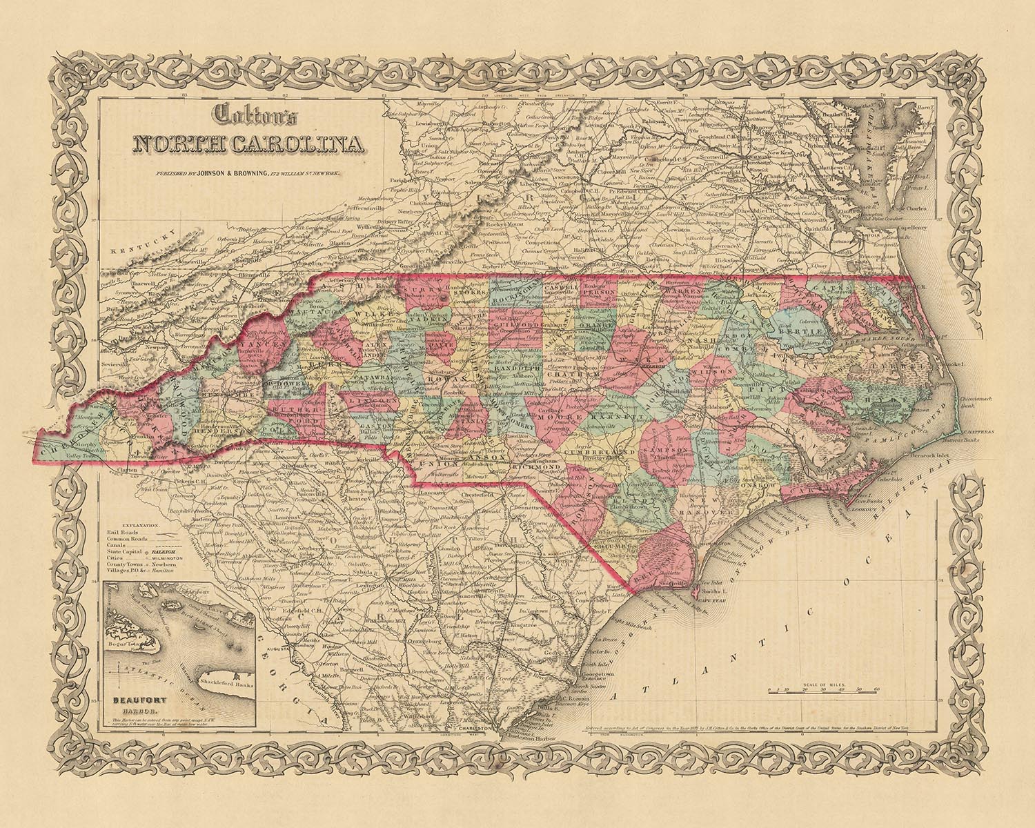
This exceptional piece of cartographic history is an old map of North Carolina, crafted by the esteemed mapmaker J. H. Colton in 1858. Known for his precise and detailed work, Colton is widely regarded as one of the finest American mapmakers of his era. This map, depicting North Carolina in the mid-19th century, is a testament to his skill and dedication to the art of cartography.
Created just a few decades after the birth of the United States, this map provides a unique snapshot of the country's early development. At this point in history, many settlements that we know today were yet to be founded, and the landscape of the country was vastly different from what we see today. The map captures the essence of this era, showcasing the growth and expansion of the United States during a time of rapid change and development.
It's fascinating to note that the names and borders of many places have likely changed over the last 150 years. This map offers a unique opportunity to delve into the past and understand how the region has evolved over time. The settlements of Raleigh, Wilmington, New Bern, Fayetteville, and Asheville, which were notable even in 1858, are beautifully depicted on this map.
This map is a remarkable piece of history, providing a glimpse into the past and offering a sense of how far we've come. It's not just a map, but a story of progress, development, and the relentless human spirit that drives us forward. Whether you're a history enthusiast, a cartography lover, or simply someone who appreciates the beauty of old maps, this piece is sure to captivate and inspire.
The craftsmanship of J. H. Colton is evident in every detail of this map. From the meticulous depiction of the settlements to the precise borders, every aspect of this map is a testament to his skill and dedication. This map is more than just a piece of history - it's a work of art that reflects the spirit of an era.
In conclusion, this old map of North Carolina by J. H. Colton is a stunning piece of cartographic history. It offers a unique glimpse into the past, capturing the essence of a time when the United States was still in its early stages of development. Whether you're a lover of history, maps, or both, this piece is sure to be a fascinating addition to your collection.
Towns, Cities, Counties, and Settlements in North Carolina
- Raleigh (1792): Known as the "City of Oaks" for its many oak trees, Raleigh is the capital city of North Carolina. It was named after Sir Walter Raleigh, who attempted to establish the first English colony in the New World in the late 16th century.
- Wilmington (1739): A port city, Wilmington was crucial for naval supplies during the American Civil War. It was named after Spencer Compton, Earl of Wilmington.
- New Bern (1710): The second oldest town in North Carolina, New Bern was the colonial capital of North Carolina. It was named after the city of Bern in Switzerland.
- Fayetteville (1783): Named after Marquis de Lafayette, a French military hero who significantly aided the American forces during the Revolutionary War.
- Asheville (1797): Known for its vibrant arts scene and historic architecture, Asheville was named after North Carolina Governor Samuel Ashe.
- Edenton (1712): Named after Governor Charles Eden, Edenton served as the state capital until 1743.
- Hillsborough (1754): Known for its role in the Regulator movement, an uprising against British rule in the 1760s.
- Salem (1766): Known for its historic Moravian settlement, Old Salem, which is a living history museum today.
- Beaufort (1709): The third oldest town in North Carolina, Beaufort is known for its beautiful coastal scenery.
- Bath (1705): The oldest town in North Carolina, Bath was a major port during colonial times.
- Elizabeth City (1793): Known as the "Harbor of Hospitality," Elizabeth City has a rich maritime history.
- Chapel Hill (1793): Home to the University of North Carolina, the nation's first public university.
- Charlotte (1768): Named after Queen Charlotte of Mecklenburg-Strelitz, Charlotte is now the largest city in North Carolina.
- Greensboro (1808): Named after Major General Nathanael Greene, a hero of the American Revolutionary War.
- Durham (1823): Known for its tobacco industry and as the home of Duke University.
- Halifax (1757): Known for the Halifax Resolves, a resolution adopted by North Carolina on April 12, 1776, which was the first official action in the American Colonies calling for independence from Britain.
- Winston (1851): Known for its tobacco industry, it would later merge with the neighboring town of Salem to form Winston-Salem.
- Concord (1796): Known for its historic downtown district and as the home of Charlotte Motor Speedway.
- Pittsboro (1785): Known for its courthouse, which is one of the oldest courthouses in North Carolina.
- Goldsboro (1847): Named after Major Matthew T. Goldsborough of the North Carolina Railroad, it was a strategic railroad junction during the Civil War.
Native American Tribes
- Cherokee: The Cherokee were one of the largest tribes in the Southeast, and their ancestral lands covered a large part of North Carolina.
- Catawba: The Catawba were known as "river people" who primarily lived along the Catawba River.
- Tuscarora: The Tuscarora lived in the coastal region of North Carolina. They joined the Iroquois Confederacy and migrated northward in the early 18th century.
- Croatan: The Croatan were a small coastal tribe, known for their interaction with the Lost Colony of Roanoke.
Notable Natural Phenomena
- Appalachian Mountains: A significant mountain range in the eastern United States, extending into the western part of North Carolina.
- Cape Hatteras: Known for its iconic lighthouse, Cape Hatteras is a popular tourist destination.
- Great Smoky Mountains: Home to the Great Smoky Mountains National Park, the most visited national park in the United States.
- Blue Ridge Parkway: A scenic highway that runs through the Appalachian Mountains.
- Outer Banks: A chain of barrier islands off the coast of North Carolina, known for their beaches and wild horses.
Historical Events (1810-1858)
- War of 1812 (1812-1815): Although no major battles occurred in North Carolina, the state sent troops and supplies to aid the war effort.
- North Carolina Gold Rush (1799-1849): The first gold rush in the United States began in North Carolina, following the discovery of a 17-pound gold nugget.
- Construction of the North Carolina Railroad (1851): This was a significant development that boosted the state's economy and led to the growth of several towns and cities.
Please double check the images to make sure that a specific town or place is shown on this map. You can also get in touch and ask us to check the map for you.
This map looks great at all sizes: 12x16in (30.5x41cm), 16x20in (40.5x51cm), 18x24in (45.5x61cm), 24x30in (61x76cm), 32x40in (81.5x102cm), 40x50in (102x127cm), 48x60in (122x153cm) and 56x70in (142x178cm), but it looks even better when printed large.
I can create beautiful, large prints of this map up to 70in (178cm). Please get in touch if you're looking for larger, customised or different framing options.
The model in the listing images is holding the 16x20in (40.5x51cm) version of this map.
The fifth listing image shows an example of my map personalisation service.
If you’re looking for something slightly different, check out my main collection of USA and North America maps.
Please contact me to check if a certain location, landmark or feature is shown on this map.
This would make a wonderful birthday, Christmas, Father's Day, work leaving, anniversary or housewarming gift for someone from the areas covered by this map.
This map is available as a giclée print on acid free archival matte paper, or you can buy it framed. The frame is a nice, simple black frame that suits most aesthetics. Please get in touch if you'd like a different frame colour or material. My frames are glazed with super-clear museum-grade acrylic (perspex/acrylite), which is significantly less reflective than glass, safer, and will always arrive in perfect condition.
This map is also available as a float framed canvas, sometimes known as a shadow gap framed canvas or canvas floater. The map is printed on artist's cotton canvas and then stretched over a handmade box frame. We then "float" the canvas inside a wooden frame, which is available in a range of colours (black, dark brown, oak, antique gold and white). This is a wonderful way to present a map without glazing in front. See some examples of float framed canvas maps and explore the differences between my different finishes.
For something truly unique, this map is also available in "Unique 3D", our trademarked process that dramatically transforms the map so that it has a wonderful sense of depth. We combine the original map with detailed topography and elevation data, so that mountains and the terrain really "pop". For more info and examples of 3D maps, check my Unique 3D page.
For most orders, delivery time is about 3 working days. Personalised and customised products take longer, as I have to do the personalisation and send it to you for approval, which usually takes 1 or 2 days.
Please note that very large framed orders usually take longer to make and deliver.
If you need your order to arrive by a certain date, please contact me before you order so that we can find the best way of making sure you get your order in time.
I print and frame maps and artwork in 23 countries around the world. This means your order will be made locally, which cuts down on delivery time and ensures that it won't be damaged during delivery. You'll never pay customs or import duty, and we'll put less CO2 into the air.
All of my maps and art prints are well packaged and sent in a rugged tube if unframed, or surrounded by foam if framed.
I try to send out all orders within 1 or 2 days of receiving your order, though some products (like face masks, mugs and tote bags) can take longer to make.
If you select Express Delivery at checkout your order we will prioritise your order and send it out by 1-day courier (Fedex, DHL, UPS, Parcelforce).
Next Day delivery is also available in some countries (US, UK, Singapore, UAE) but please try to order early in the day so that we can get it sent out on time.
My standard frame is a gallery style black ash hardwood frame. It is simple and quite modern looking. My standard frame is around 20mm (0.8in) wide.
I use super-clear acrylic (perspex/acrylite) for the frame glass. It's lighter and safer than glass - and it looks better, as the reflectivity is lower.
Six standard frame colours are available for free (black, dark brown, dark grey, oak, white and antique gold). Custom framing and mounting/matting is available if you're looking for something else.
Most maps, art and illustrations are also available as a framed canvas. We use matte (not shiny) cotton canvas, stretch it over a sustainably sourced box wood frame, and then 'float' the piece within a wood frame. The end result is quite beautiful, and there's no glazing to get in the way.
All frames are provided "ready to hang", with either a string or brackets on the back. Very large frames will have heavy duty hanging plates and/or a mounting baton. If you have any questions, please get in touch.
See some examples of my framed maps and framed canvas maps.
Alternatively, I can also supply old maps and artwork on canvas, foam board, cotton rag and other materials.
If you want to frame your map or artwork yourself, please read my size guide first.
My maps are extremely high quality reproductions of original maps.
I source original, rare maps from libraries, auction houses and private collections around the world, restore them at my London workshop, and then use specialist giclée inks and printers to create beautiful maps that look even better than the original.
My maps are printed on acid-free archival matte (not glossy) paper that feels very high quality and almost like card. In technical terms the paper weight/thickness is 10mil/200gsm. It's perfect for framing.
I print with Epson ultrachrome giclée UV fade resistant pigment inks - some of the best inks you can find.
I can also make maps on canvas, cotton rag and other exotic materials.
Learn more about The Unique Maps Co.
Map personalisation
If you're looking for the perfect anniversary or housewarming gift, I can personalise your map to make it truly unique. For example, I can add a short message, or highlight an important location, or add your family's coat of arms.
The options are almost infinite. Please see my map personalisation page for some wonderful examples of what's possible.
To order a personalised map, select "personalise your map" before adding it to your basket.
Get in touch if you're looking for more complex customisations and personalisations.
Map ageing
I have been asked hundreds of times over the years by customers if they could buy a map that looks even older.
Well, now you can, by selecting Aged before you add a map to your basket.
All the product photos you see on this page show the map in its Original form. This is what the map looks like today.
If you select Aged, I will age your map by hand, using a special and unique process developed through years of studying old maps, talking to researchers to understand the chemistry of aging paper, and of course... lots of practice!
If you're unsure, stick to the Original colour of the map. If you want something a bit darker and older looking, go for Aged.
If you are not happy with your order for any reason, contact me and I'll get it fixed ASAP, free of charge. Please see my returns and refund policy for more information.
I am very confident you will like your restored map or art print. I have been doing this since 1984. I'm a 5-star Etsy seller. I have sold tens of thousands of maps and art prints and have over 5,000 real 5-star reviews. My work has been featured in interior design magazines, on the BBC, and on the walls of dozens of 5-star hotels.
I use a unique process to restore maps and artwork that is massively time consuming and labour intensive. Hunting down the original maps and illustrations can take months. I use state of the art and eye-wateringly expensive technology to scan and restore them. As a result, I guarantee my maps and art prints are a cut above the rest. I stand by my products and will always make sure you're 100% happy with what you receive.
Almost all of my maps and art prints look amazing at large sizes (200cm, 6.5ft+) and I can frame and deliver them to you as well, via special oversized courier. Contact me to discuss your specific needs.
Or try searching for something!


