


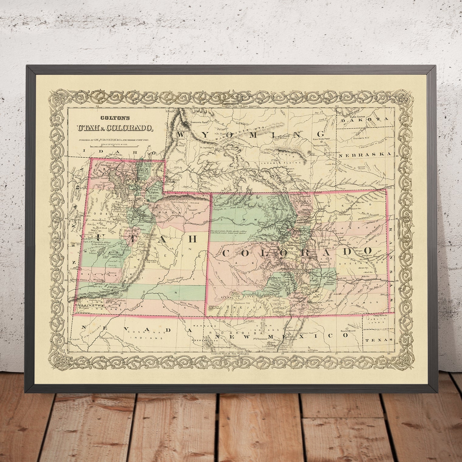


Old map of Utah & Colorado by J. H. Colton, 1873: Salt Lake City, Denver, Provo, Colorado Springs, Fort Collins
Only 1 in stock
-
Handmade in the UK
![]()
Your map will be handmade in the UK
The Unique Maps Co. is a UK-based company that prints, frames, personalises and delivers maps all around the world.
If the delivery address is in the UK, your map will be printed and framed here.
If the delivery address is outside the UK, I will print and frame the map outside of the UK. I have local production facilities in 22 countries.
This is great for gifting. For example, you can buy a map for someone in Singapore, and I'll make and deliver the map locally in Singapore with no tax or duty to be paid by the recipient.

-
Free delivery
in 2 to 3 days
Delivery in 2 to 3 days
Your map should be delivered in 2 to 3 working days with free delivery.
Express delivery is available at checkout which can reduce the delivery time to 1 to 2 days.
Please note that personalised maps, and larger framed maps, can take longer to produce and deliver.
If you need your order to arrive by a certain date, contact me and we can discuss your options.
-
Premium hardwood frames
Premium hardwood frames
My framed maps are handmade by professional, experienced framers from sustainably sourced hardwoods.
This means your framed map will feel solid and well-made.
My standard frame colours (black, dark brown, white, oak and gold) are available for all map sizes worldwide.
Custom framing is available for an additional fee.
-
Certified sustainable +
we plant trees🌳
Sustainability & Tree Planting
Here at The Unique Maps Co., we have an unusually high affinity for paper. After all, without paper, there can be no maps!
That's why all of our paper, frames and packaging are from FSC certified sources.
But we don't stop there. We've partnered with Treeapp to plant trees around the world.
If you spend £50 or more, we'll plant a tree in your name.
- 5 stars 'Excellent' rating on Trustpilot
Custom map sizes are available
At The Unique Maps Co., every order is processed and made by hand. There is no mass production and every map is custom made to order.
This means that I can tailor your map so that it perfectly fits a space on your wall, or a frame that you already own.
To order a custom sized map, select the size closest to what you need, and then select 'customise the size?' from the options below.
Custom sizing is free for large maps over 100cm or 40 inches, but for smaller maps there will be an additional small fee.
Need help ordering?
Call the workshop 9am to 5pm, or WhatsApp me any time.
Looking for a map of your city?
I can make a personalised old map of most places in the world. Contact me for more info.


Or try searching for something!
This map, a product of the renowned American mapmaker J. H. Colton, dates back to 1873, a period in history when the United States was still in its early stages of development. It provides a unique snapshot of the states of Utah and Colorado, offering a fascinating glimpse into the past when many settlements were yet to be established and the landscape was vastly different from what we know today.
During this era, the region was still being explored and charted, with many settlements just starting to take root. The map, therefore, serves as a testament to the dynamic nature of history, reflecting the changes that have taken place over the last 150 years. The names and borders depicted on the map may have evolved or changed completely, making this piece an intriguing artifact for those interested in the historical geography of the United States.
The map features the five most notable settlements of the time in Utah and Colorado: Salt Lake City, Denver, Provo, Colorado Springs, and Fort Collins. Each of these settlements has its own unique history and significance, and their depiction on this map provides a captivating insight into their early development.
Salt Lake City, the capital and most populous city of Utah, was founded in 1847 by Brigham Young and other followers of the Church of Jesus Christ of Latter-day Saints. Denver, the capital of Colorado, was established during the Pike's Peak Gold Rush in 1858. Provo, located in Utah, was settled by 33 Mormon families in 1849 and is now home to Brigham Young University.
Colorado Springs, established in 1871, was known for its scenic beauty and was often referred to as "Little London" due to its popularity among English tourists. Fort Collins, founded as a military outpost of the United States Army in 1864, is now a vibrant city and home to Colorado State University.
This map by J. H. Colton is a valuable piece for collectors, historians, and anyone with an interest in the early history of the United States. It provides a unique perspective on the development of Utah and Colorado, serving as a window into the past and a testament to the enduring power of cartography. The map's intricate details and historical significance make it a truly remarkable artifact, offering a rich tapestry of history that continues to fascinate and inspire.
Utah
- Salt Lake City (1847): Known historically as Great Salt Lake City, it's notable as the headquarters of The Church of Jesus Christ of Latter-day Saints (LDS Church).
- Provo (1849): Known for being the location of Brigham Young University, founded by the LDS Church.
- Ogden (1846): Known as Fort Buenaventura historically, it was a significant railway hub.
- Logan (1859): Known for being the location of Utah State University.
- St. George (1861): Notable for its warm climate and as the location of Dixie State University.
- Fillmore (1851): Named after President Millard Fillmore, it was Utah's first capital.
- Lehi (1850): Known historically as Dry Creek, it's notable for its early involvement in sugar beet farming.
- Cedar City (1851): Known for its proximity to rich iron mines and the Utah Shakespeare Festival.
- Brigham City (1851): Known for its peach orchards and the annual Peach Days celebration.
- Richfield (1864): Established as a farming community, it's the largest city in central Utah.
Colorado
- Denver (1858): Known historically as Denver City, it was a mining town during the gold rush.
- Colorado Springs (1871): Known for its scenic beauty and proximity to Pikes Peak.
- Boulder (1859): Established as a base for miners, it's now home to the University of Colorado.
- Golden (1859): Known historically as Golden City, it was the capital of the Colorado Territory.
- Pueblo (1842): Established as Fort Pueblo, it was a significant trading post.
- Leadville (1859): Known for its silver mining, it's one of the highest incorporated cities in the U.S.
- Greeley (1869): Known for its experimental utopian society, the Union Colony.
- Fort Collins (1864): Established as a military outpost, it's now home to Colorado State University.
- Durango (1880): Known for the Durango and Silverton Narrow Gauge Railroad.
- Canon City (1858): Known for its rich fossil areas and the Royal Gorge Bridge.
Native American Tribes
- Ute Tribe: Indigenous to Utah, known for their hunting and gathering lifestyle.
- Shoshone Tribe: Occupied parts of northern Utah, known for their horse culture.
- Paiute Tribe: Inhabited parts of southern Utah, known for their pottery and basketry.
- Cheyenne Tribe: Native to Colorado, known for their warrior culture.
- Arapaho Tribe: Occupied parts of Colorado, known for their peaceful nature and trade practices.
Natural Attractions
- Great Salt Lake: The largest saltwater lake in the Western Hemisphere.
- Rocky Mountain National Park: Known for its stunning mountain vistas.
- Colorado River: Famous for carving the Grand Canyon.
- Pikes Peak: The most visited mountain in North America.
- Garden of the Gods: Known for its towering sandstone rock formations.
Historical Events
- Pike's Peak Gold Rush (1858-1861): Led to the creation of the Colorado Territory.
- Utah War (1857-1858): A conflict between the U.S. government and the LDS Church.
- Colorado War (1863-1865): A conflict between the U.S. and the Cheyenne, Arapaho, and Sioux tribes.
- Creation of the Colorado Territory (1861): Formed from parts of the Kansas, Nebraska, Utah, and New Mexico territories.
- Joining of the Transcontinental Railroad (1869): Promontory Summit, Utah became the meeting point of the Union and Central Pacific Railroads.
Please double check the images to make sure that a specific town or place is shown on this map. You can also get in touch and ask us to check the map for you.
This map looks great at all sizes: 18x12in (46x30.5cm), 18x24in (45.5x61cm), 24x36in (61x91.5cm), 30x45in (76x114.5cm), 33x50in (84x127cm), 40x60in (102x153cm) and 47x70in (120x178cm), but it looks even better when printed large.
I can create beautiful, large prints of this map up to 70in (178cm). Please get in touch if you're looking for larger, customised or different framing options.
The model in the listing images is holding the 16x20in (40.5x51cm) version of this map.
The fifth listing image shows an example of my map personalisation service.
If you’re looking for something slightly different, check out my main collection of USA and North America maps.
Please contact me to check if a certain location, landmark or feature is shown on this map.
This would make a wonderful birthday, Christmas, Father's Day, work leaving, anniversary or housewarming gift for someone from the areas covered by this map.
This map is available as a giclée print on acid free archival matte paper, or you can buy it framed. The frame is a nice, simple black frame that suits most aesthetics. Please get in touch if you'd like a different frame colour or material. My frames are glazed with super-clear museum-grade acrylic (perspex/acrylite), which is significantly less reflective than glass, safer, and will always arrive in perfect condition.
My standard frame is a gallery style black ash hardwood frame. It is simple and quite modern looking. On maps up to 36 inches (91cm) the frame is 1.5-3cm (0.6in to 1in) wide. I use thicker frames on larger maps - usually between 35 and 60mm (1.4in to 2.4in).
In all cases I use super-clear acrylic (perspex/acrylite) for the frame glass. It's lighter and safer than glass - and it looks better, as the reflectivity is lower.
All frames are provided "ready to hang", with either a string or brackets on the back. Very large frames will have heavy duty hanging plates and/or a mounting baton. If you have any questions, please get in touch.
See some examples of my framed maps and framed canvas maps.
A few different frame colours are available for free (black, brown, white, oak and antique gold). Custom framing and mounting/matting is available if you're looking for something else.
Alternatively, I can also supply old maps on canvas, foam board, cotton rag and other materials.
If you want to frame your map yourself, please read my map size guide first.
For most orders, delivery time is about 3 working days. Personalised and custom made maps take longer, as I have to do the personalisation and send it to you for approval, which usually takes a day or two.
Please note that for larger framed orders (over 40in/100cm), and some other framed sizes, the delivery time will be closer to 7-10 days.
If you need your order to arrive by a certain date, please contact me before you order so that we can find the best way of making sure you get your order in time.
I have specialist printing and framing facilities in 17 countries around the world. This means your map will be made locally, which cuts down on delivery time and reduces the chance of your map being damaged during delivery. There won't be any extra taxes or duties to pay, and we'll put less CO2 into the air.
All of my maps are well packaged and sent in a rugged tube if unframed, or surrounded by foam if framed.
I try to send out all maps within 1 or 2 days of receiving your order, though some products (like face masks or mugs) can take longer to make.
If you select Express Delivery at checkout your order we will prioritise your order and send it out by 1-day courier (Fedex, DHL, UPS, Parcelforce).
We can sometimes do next-day delivery if you order before 10am. But usually it's best to contact me first before you order.
My maps are extremely high quality reproductions of original maps.
I source original, extremely rare maps from libraries, auction houses and private collections around the world, restore them at my London workshop, and then use specialist giclée inks and printers to create beautiful maps that look even better than the original.
My maps are printed on acid-free archival matte (not glossy) paper that feels very high quality and almost like card. In technical terms the paper weight/thickness is 10mil/200gsm. It's perfect for framing.
I print with Epson ultrachrome giclée UV fade resistant pigment inks - some of the best inks you can find.
I can also make maps on canvas, cotton rag and other exotic materials.
Learn more about how the Unique Maps Co. sources and restores old maps
Map personalisation
If you're looking for the perfect anniversary or housewarming gift, I can personalise your map to make it truly unique. For example, I can add a short message, or highlight an important location, or add your family's coat of arms.
The options are almost infinite. Please see my map personalisation page for some wonderful examples of what's possible.
To order a personalised map, select "personalise your map" before adding it to your basket.
Get in touch if you're looking for more complex customisations and personalisations.
If you are not happy with your unique map for any reason, contact me for a no-quibble refund.
I am very confident you will like your old map. I have been doing this since 1984. I'm a 5-star Etsy seller. I have sold tens of thousands of maps and have over 1,500 real 5-star reviews.
I use a unique process to restore my maps that is massively time consuming and labour intensive. Hunting down the original maps can take months. I use state of the art and eye-wateringly expensive technology to scan and restore the maps. As a result, I guarantee my maps are a cut above the rest - that's why I can offer a no-quibble refund.
Almost all of my maps look amazing at large sizes (200cm, 6.5ft+) and I can frame and deliver them to you as well, via special oversized courier. Contact me to discuss your specific needs.


