


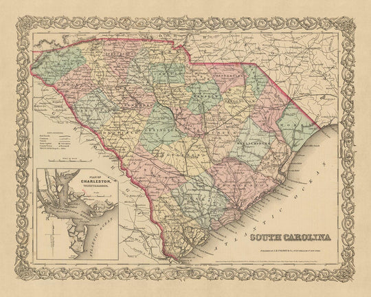


Old Map of South Carolina by Colton, 1859: Charleston, Columbia, Greenville, Spartanburg, Sumter

-
![]() Handmade in Mexico
Handmade in Mexico
-
FREE worldwide delivery in 2-3 days ⓘ
Free delivery in 2-3 days
Your map should be delivered in 2-3 working days with free delivery, worldwide.
We make maps by hand locally in 23 countries, including Mexico
![]() . If you're buying a gift for someone in another country, we will make the map locally to them.
. If you're buying a gift for someone in another country, we will make the map locally to them.You will never pay import tax or customs duty.
Express delivery is available at checkout which can reduce the delivery time to 1-2 days.
Please note that personalised maps, and larger framed maps, can take longer to produce and deliver.
If you need your order to arrive by a certain date, contact me and we can discuss your options.
-
90 day money back guarantee ⓘ
90 days to return and refund
Products can be returned within 90 days for a full refund, or exchange for another product.
For personalised or custom made items, we may offer you a non-expiring gift card, as we cannot resell personalised orders.
If you have any questions, get in touch. For more information, see our full returns & exchanges policy.

My maps are rare, museum-grade, restored old maps sourced from libraries, auction houses and private collections across the globe.
Framing & free personalisation available
1. Select your size
2. Customise your map
Personalise your map with framing, hand-drawn customisation, vintage ageing, pop art text, unique 3D styling and moreGift message & custom finish

If you want to add a gift message, or a finish (jigsaw, aluminium board, etc.) that is not available here, please request it in the "order note" when you check out.
Every order is custom made, so if you need the size adjusted slightly, or printed on an unusual material, just let us know. We've done thousands of custom orders over the years, so there's (almost) nothing we can't manage.
You can also contact us before you order, if you prefer!

- Handmade locally. No import duty or tax
- FREE Delivery. Arrives in 2-3 days
- Love it or your money back
- Questions? WhatsApp me any time
Own a piece of history
5,000+ 5 star reviews


Immerse yourself in the rich tapestry of American history with this exquisite map of South Carolina, crafted in 1859 by the renowned mapmaker J. H. Colton. This piece hails from a time when the United States was still in its infancy, and the nation's landscape was largely uncharted and ever-changing. As such, this map serves as a fascinating window into the past, providing a snapshot of South Carolina as it was over 150 years ago.
At the time this map was made, many of the settlements we know today were yet to be founded, and many of the names and borders have likely changed. This map features the five most notable settlements in South Carolina in 1855: Charleston, Columbia, Greenville, Spartanburg, and Sumter. Each of these locations carries its own unique history and significance, which is beautifully captured in the intricate details of this map.
J. H. Colton, the mapmaker behind this piece, is generally considered the finest American mapmaker of his era. His work is characterized by its meticulous attention to detail and its high level of accuracy. This map of South Carolina is no exception, showcasing Colton's unparalleled skill and dedication to his craft.
This map is more than just a piece of history; it's a testament to the early days of American exploration and the pioneering spirit that defined this era. It's a tribute to the towns and cities that have shaped South Carolina into the state it is today. And most importantly, it's a work of art, meticulously crafted by one of the most esteemed mapmakers of the 19th century. This is more than just a map - it's a piece of American history, and a testament to the timeless art of cartography.
Whether you're a history enthusiast, a lover of maps, or simply someone who appreciates fine craftsmanship, this map of South Carolina by J. H. Colton is a must-have. It's not just a map, but a journey back in time, offering a glimpse into the past that is as fascinating as it is educational. So why not take a step back in time and explore the history of South Carolina as it was in 1859? With this map, the past is never far away.
Notable Settlements in South Carolina
- Charleston (1670): Originally named Charles Town, it was one of the earliest and most significant colonial cities, renowned for its rich history, well-preserved architecture, and distinguished restaurants.
- Columbia (1786): Known as the "Capital of Southern Hospitality," Columbia was named for Christopher Columbus and became the state capital in 1786.
- Greenville (1831): Named after Revolutionary War hero Nathanael Greene, Greenville became a major cotton market and industrial center.
- Spartanburg (1831): Known as the "Hub City" due to its railroad connections, Spartanburg was a major textile manufacturing center.
- Sumter (1845): Named after General Thomas Sumter, the "Fighting Gamecock" of the American Revolutionary War.
- Beaufort (1711): The second oldest city in South Carolina, known for its scenic location and historic architecture.
- Georgetown (1729): Once one of the wealthiest colonies in the world, known for its rice plantations.
- Camden (1733): The oldest inland city in South Carolina, it played key roles in the Revolutionary War.
- Orangeburg (1704): Named after William IV, Prince of Orange, it was an important trading center and route to the western territories.
- Anderson (1826): Known as "The Electric City" for being the first city in the United States with a continuous supply of electric power.
- Aiken (1835): Known for its health resort, it attracted wealthy Northerners who built winter homes here.
- Rock Hill (1852): Known for its textile mills and as the largest city in York County.
- Abbeville (1785): Known as the "Birthplace and Deathbed of the Confederacy."
- Lexington (1735): Known for its rich soil, it was an important agricultural area.
- Chester (1785): Known for its historic downtown area and the Chester County Courthouse, designed by Robert Mills.
- Newberry (1789): Known for Newberry College and the Newberry Opera House.
- Union (1791): Known for its historic homes and the Battle of Blackstock's Farm during the Revolutionary War.
- Gaffney (1804): Known for the Gaffney Peachoid, a water tower shaped like a peach.
- Laurens (1785): Known for its historic downtown area and the Laurens County Courthouse.
- Clinton (1852): Known for being the home of Presbyterian College.
Native American Tribes in South Carolina
- Cherokee: The largest tribe in South Carolina, they occupied the mountainous region of the state.
- Catawba: Known as "River People," they resided along the Catawba River.
- Yamasee: A multiethnic confederation, they were involved in the Yamasee War against British colonists.
- Congaree: A small tribe, they lived along the Congaree River.
Notable Natural Features
- Blue Ridge Mountains: Part of the Appalachian Mountains, it's known for its scenic beauty.
- Congaree River: Formed by the confluence of the Saluda and Broad Rivers near Columbia.
- Santee River: Known for its surrounding swamp, a unique ecosystem.
- Table Rock State Park: Known for its towering mountain and challenging hiking trails.
- Lake Marion: The largest lake in South Carolina, known for its fishing and boating.
Historical Events (1810-1859)
- Nullification Crisis (1832-1833): A major event in South Carolina's history, it involved a confrontation between South Carolina and the federal government.
- The Burning of Columbia (1865): Towards the end of the Civil War, much of Columbia was destroyed by fire.
Please double check the images to make sure that a specific town or place is shown on this map. You can also get in touch and ask us to check the map for you.
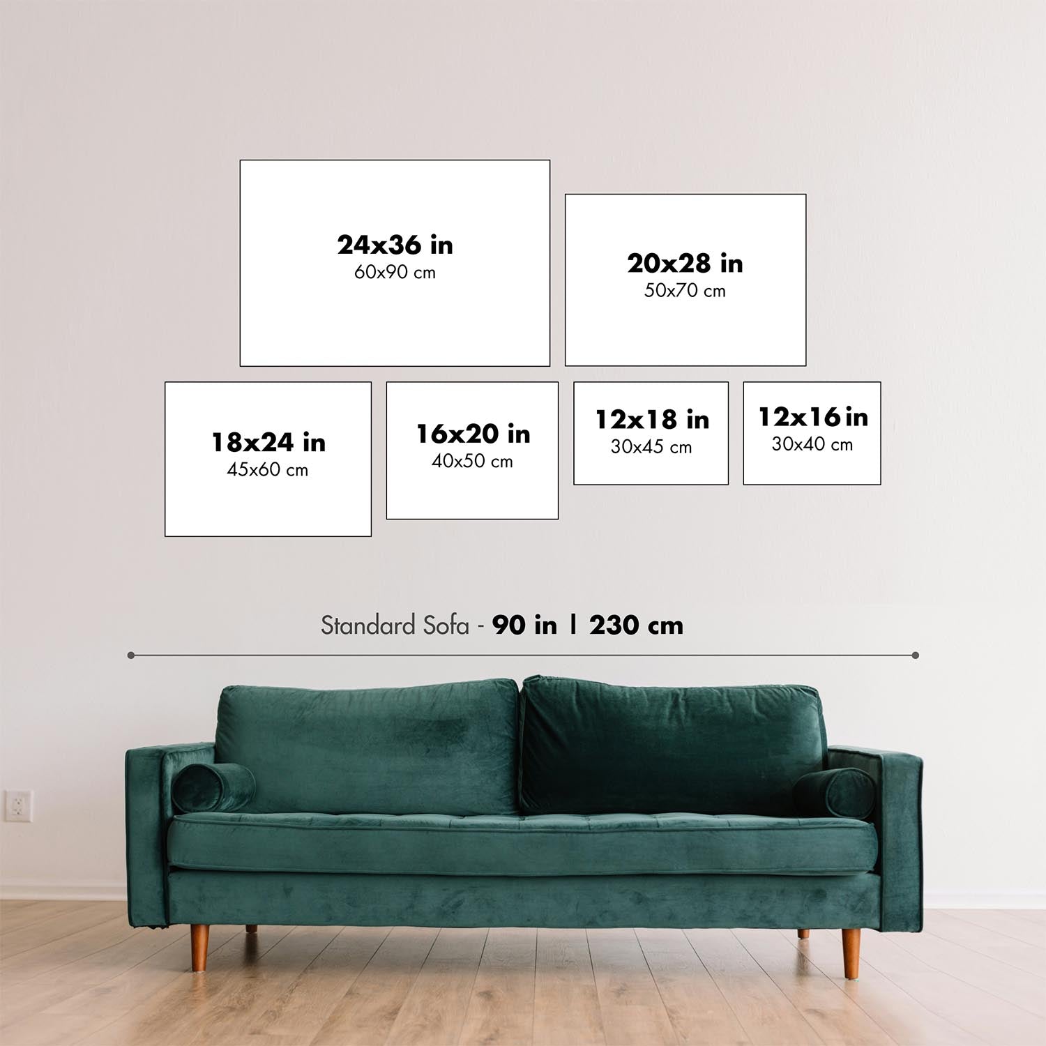
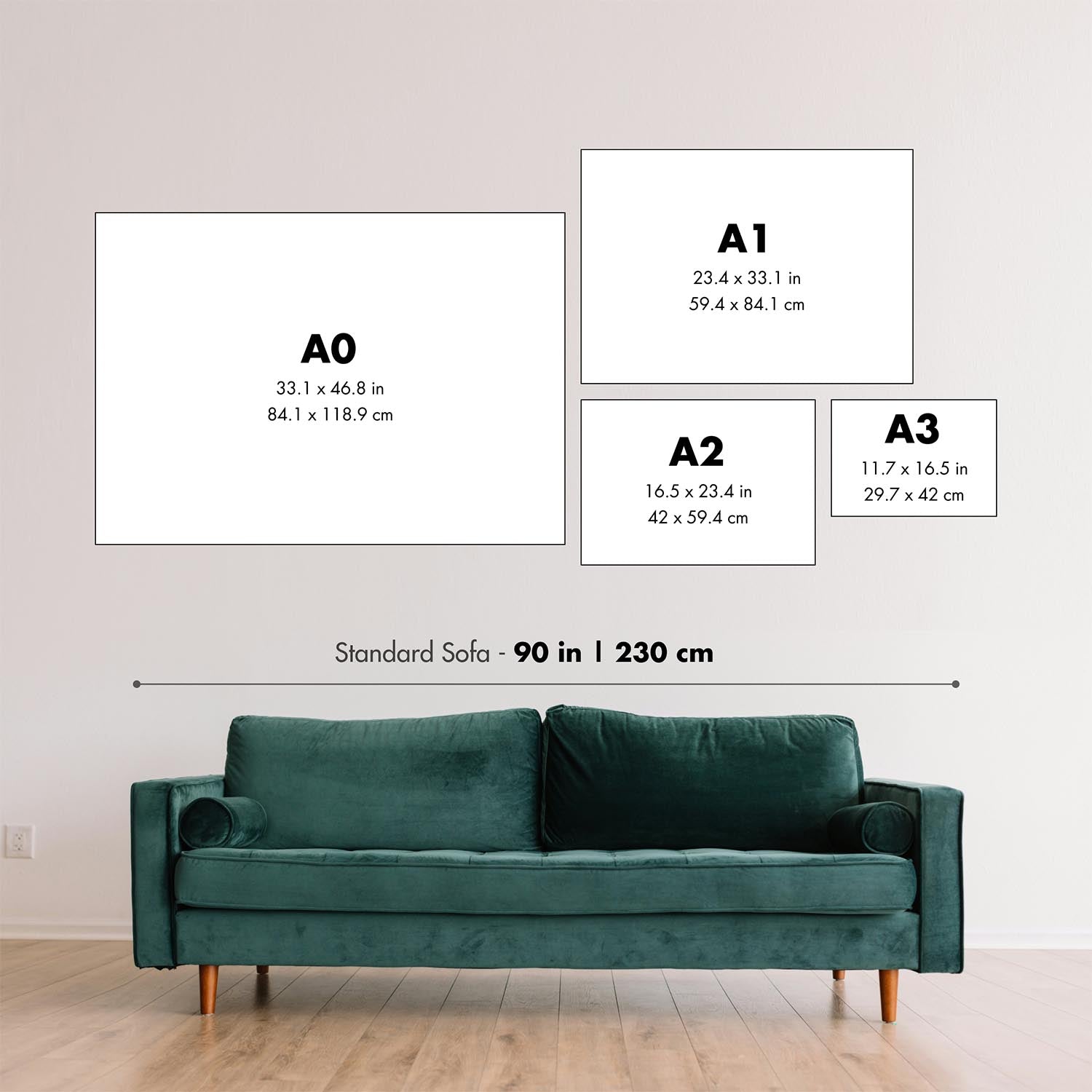
This map looks great at all sizes: 12x16in (30.5x41cm), 16x20in (40.5x51cm), 18x24in (45.5x61cm), 24x30in (61x76cm), 32x40in (81.5x102cm), 40x50in (102x127cm), 48x60in (122x153cm) and 56x70in (142x178cm), but it looks even better when printed large.
I can create beautiful, large prints of this map up to 70in (178cm). Please get in touch if you're looking for larger, customised or different framing options.
The model in the listing images is holding the 16x20in (40.5x51cm) version of this map.
The fifth listing image shows an example of my map personalisation service.
If you’re looking for something slightly different, check out my main collection of USA and North America maps.
Please contact me to check if a certain location, landmark or feature is shown on this map.
This would make a wonderful birthday, Christmas, Father's Day, work leaving, anniversary or housewarming gift for someone from the areas covered by this map.
This map is available as a giclée print on acid free archival matte paper, or you can buy it framed. The frame is a nice, simple black frame that suits most aesthetics. Please get in touch if you'd like a different frame colour or material. My frames are glazed with super-clear museum-grade acrylic (perspex/acrylite), which is significantly less reflective than glass, safer, and will always arrive in perfect condition.
This map is also available as a float framed canvas, sometimes known as a shadow gap framed canvas or canvas floater. The map is printed on artist's cotton canvas and then stretched over a handmade box frame. We then "float" the canvas inside a wooden frame, which is available in a range of colours (black, dark brown, oak, antique gold and white). This is a wonderful way to present a map without glazing in front. See some examples of float framed canvas maps and explore the differences between my different finishes.
For something truly unique, this map is also available in "Unique 3D", our trademarked process that dramatically transforms the map so that it has a wonderful sense of depth. We combine the original map with detailed topography and elevation data, so that mountains and the terrain really "pop". For more info and examples of 3D maps, check my Unique 3D page.
For most orders, delivery time is about 3 working days. Personalised and customised products take longer, as I have to do the personalisation and send it to you for approval, which usually takes 1 or 2 days.
Please note that very large framed orders usually take longer to make and deliver.
If you need your order to arrive by a certain date, please contact me before you order so that we can find the best way of making sure you get your order in time.
I print and frame maps and artwork in 23 countries around the world. This means your order will be made locally, which cuts down on delivery time and ensures that it won't be damaged during delivery. You'll never pay customs or import duty, and we'll put less CO2 into the air.
All of my maps and art prints are well packaged and sent in a rugged tube if unframed, or surrounded by foam if framed.
I try to send out all orders within 1 or 2 days of receiving your order, though some products (like face masks, mugs and tote bags) can take longer to make.
If you select Express Delivery at checkout your order we will prioritise your order and send it out by 1-day courier (Fedex, DHL, UPS, Parcelforce).
Next Day delivery is also available in some countries (US, UK, Singapore, UAE) but please try to order early in the day so that we can get it sent out on time.
My standard frame is a gallery style black ash hardwood frame. It is simple and quite modern looking. My standard frame is around 20mm (0.8in) wide.
I use super-clear acrylic (perspex/acrylite) for the frame glass. It's lighter and safer than glass - and it looks better, as the reflectivity is lower.
Six standard frame colours are available for free (black, dark brown, dark grey, oak, white and antique gold). Custom framing and mounting/matting is available if you're looking for something else.
Most maps, art and illustrations are also available as a framed canvas. We use matte (not shiny) cotton canvas, stretch it over a sustainably sourced box wood frame, and then 'float' the piece within a wood frame. The end result is quite beautiful, and there's no glazing to get in the way.
All frames are provided "ready to hang", with either a string or brackets on the back. Very large frames will have heavy duty hanging plates and/or a mounting baton. If you have any questions, please get in touch.
See some examples of my framed maps and framed canvas maps.
Alternatively, I can also supply old maps and artwork on canvas, foam board, cotton rag and other materials.
If you want to frame your map or artwork yourself, please read my size guide first.
My maps are extremely high quality reproductions of original maps.
I source original, rare maps from libraries, auction houses and private collections around the world, restore them at my London workshop, and then use specialist giclée inks and printers to create beautiful maps that look even better than the original.
My maps are printed on acid-free archival matte (not glossy) paper that feels very high quality and almost like card. In technical terms the paper weight/thickness is 10mil/200gsm. It's perfect for framing.
I print with Epson ultrachrome giclée UV fade resistant pigment inks - some of the best inks you can find.
I can also make maps on canvas, cotton rag and other exotic materials.
Learn more about The Unique Maps Co.
Map personalisation
If you're looking for the perfect anniversary or housewarming gift, I can personalise your map to make it truly unique. For example, I can add a short message, or highlight an important location, or add your family's coat of arms.
The options are almost infinite. Please see my map personalisation page for some wonderful examples of what's possible.
To order a personalised map, select "personalise your map" before adding it to your basket.
Get in touch if you're looking for more complex customisations and personalisations.
Map ageing
I have been asked hundreds of times over the years by customers if they could buy a map that looks even older.
Well, now you can, by selecting Aged before you add a map to your basket.
All the product photos you see on this page show the map in its Original form. This is what the map looks like today.
If you select Aged, I will age your map by hand, using a special and unique process developed through years of studying old maps, talking to researchers to understand the chemistry of aging paper, and of course... lots of practice!
If you're unsure, stick to the Original colour of the map. If you want something a bit darker and older looking, go for Aged.
If you are not happy with your order for any reason, contact me for a no-quibble refund. Please see our returns and refund policy for more information.
I am very confident you will like your restored map or art print. I have been doing this since 1984. I'm a 5-star Etsy seller. I have sold tens of thousands of maps and art prints and have over 5,000 real 5-star reviews.
I use a unique process to restore maps and artwork that is massively time consuming and labour intensive. Hunting down the original maps and illustrations can take months. I use state of the art and eye-wateringly expensive technology to scan and restore them. As a result, I guarantee my maps and art prints are a cut above the rest - that's why I can offer a no-quibble refund.
Almost all of my maps and art prints look amazing at large sizes (200cm, 6.5ft+) and I can frame and deliver them to you as well, via special oversized courier. Contact me to discuss your specific needs.
Or try searching for something!


