


Rare Old Birdseye Map of Goa by Linschoten, 1596: Harbor, Fortifications, Churches, City Center, Lakes
The Collector’s Offer
Choose two eligible works and receive 20% off both. Choose three and the lowest-priced one is complimentary, a maximum saving of 33%.
Mix and match eligible standard maps and fine-art prints. No code is required; the offer is applied automatically at checkout.
Standard made-to-order configurations are included. Bespoke sizes, personalised designs and commissioned work are excluded.
Need delivery to different addresses? Contact us before ordering.The Collector’s Offer
Choose two eligible works and receive 20% off both. Choose three and the lowest-priced one is complimentary, a maximum saving of 33%.
Mix and match eligible standard maps and fine-art prints. No code is required; the offer is applied automatically at checkout.
Standard made-to-order configurations are included. Bespoke sizes, personalised designs and commissioned work are excluded.
Need delivery to different addresses? Contact us before ordering.
Restored from the original 1596 map and printed to museum-grade archival standards. Read the story behind this map
Choose your size
Choose your finish


(More info)
Gift message & custom finish

If you want to add a gift message, or a finish (jigsaw, aluminium board, etc.) that is not available here, please request it in the "order note" when you check out.
Every order is custom made, so if you need the size adjusted slightly, or printed on an unusual material, just let us know. We've done thousands of custom orders over the years, so there's (almost) nothing we can't manage.
You can also contact us before you order, if you prefer!

- Made locally for fast, safe delivery
- No import duty or hidden fees
- Need advice? Call us or message on WhatsApp
Own a piece of history
8,000+ five-star reviews


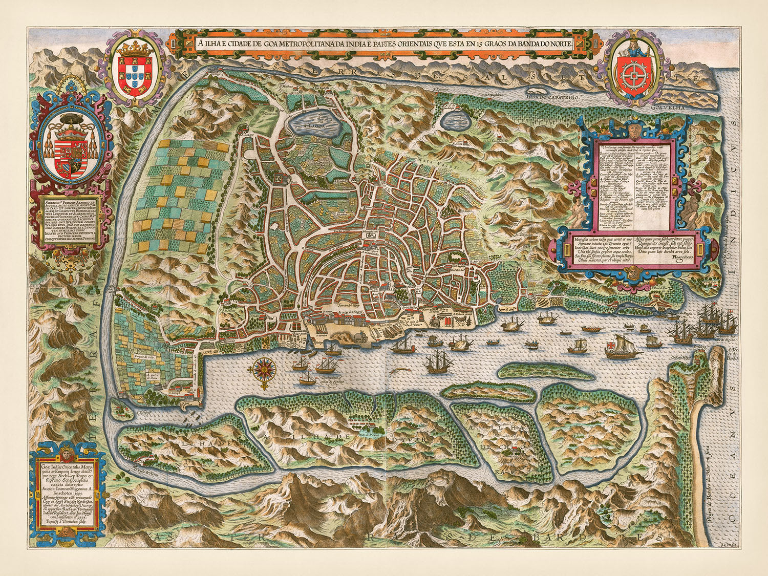
"A Ilha e Cidade de Goa Metropolitana da India E Partes Orientais que esta en 15 Graos da Banda da Norte," created...
Continue reading"A Ilha e Cidade de Goa Metropolitana da India E Partes Orientais que esta en 15 Graos da Banda da Norte," created by Jan Huygen van Linschoten in 1596, offers a mesmerizing bird's-eye view of Goa, the epicenter of the Portuguese Empire in the East during the 16th century. This decorative and detailed map not only captures the intricate layout of the city but also the bustling harbor teeming with ships, reflecting Goa's pivotal role in maritime trade. The map's vibrant illustrations and meticulous engravings by Baptista van Deutecum make it a masterpiece of cartographic art, providing a vivid glimpse into the past.
Jan Huygen van Linschoten, a key figure in the Age of Exploration, served as the bookkeeper for the Archbishop of Goa from 1583 to 1589. His privileged position granted him access to secret nautical maps and commercial information, which he meticulously copied. Linschoten's work became instrumental in guiding Dutch voyages to the East, breaking the Portuguese monopoly on the spice trade. His detailed accounts and maps, including this one of Goa, are considered some of the most important travel works of the period.
The map of Goa is rich with notable features, including the city's dense network of streets and significant landmarks. The fortifications along the harbor and city perimeter highlight the strategic importance of Goa in protecting Portuguese interests. Several churches, depicted with architectural precision, underscore the city's role as a religious center. The harbor itself, bustling with various ships, showcases the vibrant maritime activity that made Goa a crucial node in global trade networks.
Surrounding the city, the map illustrates the natural terrain with remarkable detail. Two lakes are prominently featured, adding to the geographical context of the region. The western part of the map shows fields and agricultural areas, indicating the city's self-sustaining capabilities and the richness of the land. This combination of urban and rural elements provides a comprehensive view of Goa's landscape during its peak as a commercial and political hub.
The streets of Goa, meticulously labeled on the map, weave a complex tapestry of the city's layout. Names like Rua de Santa Catarina, Rua dos Mercadores, and Rua do Comércio hint at the bustling commercial activity that characterized the city. These streets, along with others such as Rua do Palácio and Rua do Convento, paint a picture of a vibrant, well-organized urban center. Each street name evokes the historical significance and the daily life of Goa's inhabitants, making this map not just a geographical document but a portal into the past.
Streets and roads on this map
- Rua de Santa Catarina
- Rua Direita
- Rua dos Mercadores
- Rua Nova
- Rua de São Paulo
- Rua de São Tomé
- Rua de Santo Antonio
- Rua de São Francisco
- Rua de São João
- Rua de São Lourenço
- Rua de São Pedro
- Rua de São Sebastião
- Rua de São Vicente
- Rua dos Ferreiros
- Rua do Arsenal
- Rua do Carmo
- Rua do Comércio
- Rua do Convento
- Rua do Hospital
- Rua do Mercado
- Rua do Palácio
- Rua do Tesouro
- Rua dos Ourives
- Rua dos Sapateiros
- Rua das Flores
- Rua dos Pescadores
- Rua do Colégio
- Rua do Monastério
- Rua do Porto
- Rua do Terreiro
Notable Features & Landmarks
- Illustrations:
- Ships: Various ships in the harbor and surrounding waters.
- Coats of arms: Decorative crests and coats of arms.
- Landmarks:
- Fortifications: Visible along the harbor and city perimeter.
- Churches: Several church buildings are illustrated and labeled.
- Harbor: Detailed depiction of the harbor area with docks and ships.
- Neighborhoods:
- City center: Dense network of streets and buildings indicating the main urban area.
- Lakes:
- Two lakes: Depicted in the surrounding landscape.
- Large parks:
- Fields and agricultural areas: Shown in the western part of the map.
Historical and design context
- Name of the map: A Ilha e Cidade de Goa Metropolitana da India E Partes Orientais que esta en 15 Graos da Banda da Norte
- Date created: 1596
- Mapmaker/Publisher: Jan Huygen van Linschoten
- Engraver: Baptista van Deutecum
- Location of publication: Amsterdam
- Context about the mapmaker: Jan Huygen van Linschoten served as the bookkeeper for the Archbishop of Goa from 1583 to 1589. During this time, he had access to sensitive nautical maps and commercial information. He meticulously copied these maps and used them to create his own works.
- Historical significance:
- Goa's importance: At the time, Goa was the commercial and political center for the Portuguese Empire in the East.
- Linschoten's influence: Linschoten's work provided valuable information for future Dutch voyages to the East, making him a key figure in the Age of Exploration.
- Design and style:
- Type: City bird's-eye view pictorial map
- Details: Decorative and detailed, showing the city and harbor of Goa.
- Engravings: Includes intricate illustrations of the city layout, ships, and surrounding landscape.
- Themes and topics:
- City layout: Detailed depiction of the streets, buildings, and notable landmarks of Goa.
- Harbor: Illustration of the harbor with various ships, indicating maritime activity.
- Surrounding landscape: Depiction of the natural terrain around the city, including hills and fields.
Please double check the images to make sure that a specific town or place is shown on this map. You can also get in touch and ask us to check the map for you.
This map looks great at every size, but I always recommend going for a larger size if you have space. That way you can easily make out all of the details.
This map looks amazing at sizes all the way up to 100in (250cm). If you are looking for a larger map, please get in touch.
Please note: the labels on this map are hard to read if you order a map that is 16in (40cm) or smaller. The map is still very attractive, but if you would like to read the map easily, please buy a larger size.
The model in the listing images is holding the 18x24in (45x60cm) version of this map.
The fifth listing image shows an example of my map personalisation service.
If you’re looking for something slightly different, check out my collection of the best old maps to see if something else catches your eye.
Please contact me to check if a certain location, landmark or feature is shown on this map.
This would make a wonderful birthday, Christmas, Father's Day, work leaving, anniversary or housewarming gift for someone from the areas covered by this map.
This map is available as a giclée print on acid free archival matte paper, or you can buy it framed. The frame is a nice, simple black frame that suits most aesthetics. Please get in touch if you'd like a different frame colour or material. My frames are glazed with super-clear museum-grade acrylic (perspex/acrylite), which is significantly less reflective than glass, safer, and will always arrive in perfect condition.
This map is also available as a float framed canvas, sometimes known as a shadow gap framed canvas or canvas floater. The map is printed on artist's cotton canvas and then stretched over a handmade box frame. We then "float" the canvas inside a wooden frame, which is available in a range of colours (black, dark brown, oak, antique gold and white). This is a wonderful way to present a map without glazing in front. See some examples of float framed canvas maps and explore the differences between my different finishes.
For something truly unique, this map is also available in "Unique 3D", our trademarked process that dramatically transforms the map so that it has a wonderful sense of depth. We combine the original map with detailed topography and elevation data, so that mountains and the terrain really "pop". For more info and examples of 3D maps, check my Unique 3D page.
"A Ilha e Cidade de Goa Metropolitana da India E Partes Orientais que esta en 15 Graos da Banda da Norte," created by Jan Huygen van Linschoten in 1596, offers a mesmerizing bird's-eye view of Goa, the epicenter of the Portuguese Empire in the East during the 16th century. This decorative and detailed map not only captures the intricate layout of the city but also the bustling harbor teeming with ships, reflecting Goa's pivotal role in maritime trade. The map's vibrant illustrations and meticulous engravings by Baptista van Deutecum make it a masterpiece of cartographic art, providing a vivid glimpse into the past.
Jan Huygen van Linschoten, a key figure in the Age of Exploration, served as the bookkeeper for the Archbishop of Goa from 1583 to 1589. His privileged position granted him access to secret nautical maps and commercial information, which he meticulously copied. Linschoten's work became instrumental in guiding Dutch voyages to the East, breaking the Portuguese monopoly on the spice trade. His detailed accounts and maps, including this one of Goa, are considered some of the most important travel works of the period.
The map of Goa is rich with notable features, including the city's dense network of streets and significant landmarks. The fortifications along the harbor and city perimeter highlight the strategic importance of Goa in protecting Portuguese interests. Several churches, depicted with architectural precision, underscore the city's role as a religious center. The harbor itself, bustling with various ships, showcases the vibrant maritime activity that made Goa a crucial node in global trade networks.
Surrounding the city, the map illustrates the natural terrain with remarkable detail. Two lakes are prominently featured, adding to the geographical context of the region. The western part of the map shows fields and agricultural areas, indicating the city's self-sustaining capabilities and the richness of the land. This combination of urban and rural elements provides a comprehensive view of Goa's landscape during its peak as a commercial and political hub.
The streets of Goa, meticulously labeled on the map, weave a complex tapestry of the city's layout. Names like Rua de Santa Catarina, Rua dos Mercadores, and Rua do Comércio hint at the bustling commercial activity that characterized the city. These streets, along with others such as Rua do Palácio and Rua do Convento, paint a picture of a vibrant, well-organized urban center. Each street name evokes the historical significance and the daily life of Goa's inhabitants, making this map not just a geographical document but a portal into the past.
Streets and roads on this map
- Rua de Santa Catarina
- Rua Direita
- Rua dos Mercadores
- Rua Nova
- Rua de São Paulo
- Rua de São Tomé
- Rua de Santo Antonio
- Rua de São Francisco
- Rua de São João
- Rua de São Lourenço
- Rua de São Pedro
- Rua de São Sebastião
- Rua de São Vicente
- Rua dos Ferreiros
- Rua do Arsenal
- Rua do Carmo
- Rua do Comércio
- Rua do Convento
- Rua do Hospital
- Rua do Mercado
- Rua do Palácio
- Rua do Tesouro
- Rua dos Ourives
- Rua dos Sapateiros
- Rua das Flores
- Rua dos Pescadores
- Rua do Colégio
- Rua do Monastério
- Rua do Porto
- Rua do Terreiro
Notable Features & Landmarks
- Illustrations:
- Ships: Various ships in the harbor and surrounding waters.
- Coats of arms: Decorative crests and coats of arms.
- Landmarks:
- Fortifications: Visible along the harbor and city perimeter.
- Churches: Several church buildings are illustrated and labeled.
- Harbor: Detailed depiction of the harbor area with docks and ships.
- Neighborhoods:
- City center: Dense network of streets and buildings indicating the main urban area.
- Lakes:
- Two lakes: Depicted in the surrounding landscape.
- Large parks:
- Fields and agricultural areas: Shown in the western part of the map.
Historical and design context
- Name of the map: A Ilha e Cidade de Goa Metropolitana da India E Partes Orientais que esta en 15 Graos da Banda da Norte
- Date created: 1596
- Mapmaker/Publisher: Jan Huygen van Linschoten
- Engraver: Baptista van Deutecum
- Location of publication: Amsterdam
- Context about the mapmaker: Jan Huygen van Linschoten served as the bookkeeper for the Archbishop of Goa from 1583 to 1589. During this time, he had access to sensitive nautical maps and commercial information. He meticulously copied these maps and used them to create his own works.
- Historical significance:
- Goa's importance: At the time, Goa was the commercial and political center for the Portuguese Empire in the East.
- Linschoten's influence: Linschoten's work provided valuable information for future Dutch voyages to the East, making him a key figure in the Age of Exploration.
- Design and style:
- Type: City bird's-eye view pictorial map
- Details: Decorative and detailed, showing the city and harbor of Goa.
- Engravings: Includes intricate illustrations of the city layout, ships, and surrounding landscape.
- Themes and topics:
- City layout: Detailed depiction of the streets, buildings, and notable landmarks of Goa.
- Harbor: Illustration of the harbor with various ships, indicating maritime activity.
- Surrounding landscape: Depiction of the natural terrain around the city, including hills and fields.
Please double check the images to make sure that a specific town or place is shown on this map. You can also get in touch and ask us to check the map for you.
This map looks great at every size, but I always recommend going for a larger size if you have space. That way you can easily make out all of the details.
This map looks amazing at sizes all the way up to 100in (250cm). If you are looking for a larger map, please get in touch.
Please note: the labels on this map are hard to read if you order a map that is 16in (40cm) or smaller. The map is still very attractive, but if you would like to read the map easily, please buy a larger size.
The model in the listing images is holding the 18x24in (45x60cm) version of this map.
The fifth listing image shows an example of my map personalisation service.
If you’re looking for something slightly different, check out my collection of the best old maps to see if something else catches your eye.
Please contact me to check if a certain location, landmark or feature is shown on this map.
This would make a wonderful birthday, Christmas, Father's Day, work leaving, anniversary or housewarming gift for someone from the areas covered by this map.
This map is available as a giclée print on acid free archival matte paper, or you can buy it framed. The frame is a nice, simple black frame that suits most aesthetics. Please get in touch if you'd like a different frame colour or material. My frames are glazed with super-clear museum-grade acrylic (perspex/acrylite), which is significantly less reflective than glass, safer, and will always arrive in perfect condition.
This map is also available as a float framed canvas, sometimes known as a shadow gap framed canvas or canvas floater. The map is printed on artist's cotton canvas and then stretched over a handmade box frame. We then "float" the canvas inside a wooden frame, which is available in a range of colours (black, dark brown, oak, antique gold and white). This is a wonderful way to present a map without glazing in front. See some examples of float framed canvas maps and explore the differences between my different finishes.
For something truly unique, this map is also available in "Unique 3D", our trademarked process that dramatically transforms the map so that it has a wonderful sense of depth. We combine the original map with detailed topography and elevation data, so that mountains and the terrain really "pop". For more info and examples of 3D maps, check my Unique 3D page.
Many of our maps and art prints are chosen as thoughtful gifts for homes, offices, studies and meaningful places.
Choose a framed option for the easiest ready-to-hang gift, or choose an unframed print if the recipient may prefer to select their own frame.
We make orders locally in 23 countries around the world, so gifts can often be produced close to the recipient. This helps them arrive faster, travel more safely, and avoid customs or import duty surprises.
- We can deliver directly to the recipient
- Framed pieces arrive ready to hang
- Unframed prints are carefully packed in a strong protective tube
- Almost every order is made locally, for faster, safer gifting
- 90-day returns give the recipient time to decide
If you are not sure what to choose, please contact us. We can help you pick the right map, size, finish or delivery option.
Most orders are made locally and delivered in around 2–3 working days, depending on the product, size and destination.
We print and frame maps and artwork in 23 countries around the world, so your order is usually made close to you or your recipient. That means faster delivery, less time in transit, and no customs or import duty surprises.
Personalised and customised pieces usually take an extra 1–2 working days, because we prepare your design and send it to you for approval before printing.
Very large framed orders can take a little longer, as they need extra care in production and delivery.
Every order is carefully packaged: unframed prints are sent in a strong protective tube, while framed pieces are securely packed with protective materials around the frame.
If you need your order by a particular date, please contact us before ordering. We’ll check the best production route and delivery option for your location.
Express delivery is available at checkout for most countries. Next-day delivery is available in the UK, US, Singapore and the UAE.
Your order is covered by our 90-day returns policy and 10-year guarantee.
Our standard frame is a gallery-style black ash hardwood frame, with a simple, modern look. It is approximately 20mm (0.8in) wide. You can also view some lovely customer photos of framed maps and art.
We use super-clear acrylic glazing, also known as Perspex or Acrylite, instead of traditional glass. It is lighter, safer, and has lower reflectivity, giving the artwork a clearer, cleaner appearance.
Six standard frame colours are available at no extra cost: black, dark brown, dark grey, oak, white, and antique gold. Custom framing and mounting/matting is also available for customers looking for something more specific.
Most maps, art prints, and illustrations are also available as a framed canvas. We use matte cotton canvas, stretch it over a sustainably sourced wooden box frame, and then float the piece within a wooden outer frame. The finished result is beautifully presented, with no glazing between you and the artwork.
All frames are supplied ready to hang, with either string or brackets fitted to the back. Very large frames will include heavy-duty hanging plates and/or a mounting baton. If you have any questions, please get in touch.
We can also supply old maps and artwork on canvas, foam board, cotton rag, and other materials.
If you would prefer to frame your map or artwork yourself, please read our size guide before ordering.
My maps are extremely high quality reproductions of original maps.
I source original, rare maps from libraries, auction houses and private collections around the world, restore them at my London workshop, and then use specialist giclée inks and printers to create beautiful maps that look even better than the original.
My maps are printed on acid-free archival matte (not glossy) paper that feels very high quality and almost like card. In technical terms the paper weight/thickness is 10mil/200gsm. It's perfect for framing.
I print with Epson ultrachrome giclée UV fade resistant pigment inks - some of the best inks you can find.
I can also make maps on canvas, cotton rag and other exotic materials.
Learn more about The Unique Maps Co.
Map personalisation
If you're looking for the perfect anniversary or housewarming gift, I can personalise your map to make it truly unique. For example, I can add a short message, or highlight an important location, or add your family's coat of arms.
The options are almost infinite. Please see my map personalisation page for some wonderful examples of what's possible.
To order a personalised map, select "personalise your map" before adding it to your basket.
Get in touch if you're looking for more complex customisations and personalisations.
Map ageing
I have been asked hundreds of times over the years by customers if they could buy a map that looks even older.
Well, now you can, by selecting Aged before you add a map to your basket.
All the product photos you see on this page show the map in its Original form. This is what the map looks like today.
If you select Aged, I will age your map by hand, using a special and unique process developed through years of studying old maps, talking to researchers to understand the chemistry of aging paper, and of course... lots of practice!
If you're unsure, stick to the Original colour of the map. If you want something a bit darker and older looking, go for Aged.
If you are not happy with your order for any reason, contact me and I'll get it fixed ASAP, free of charge. Please see my returns and refund policy for more information.
I am very confident you will like your restored map or art print. I have been doing this since 1984. I'm a 5-star Etsy seller. I have sold tens of thousands of maps and art prints and have over 5,000 real 5-star reviews. My work has been featured in interior design magazines, on the BBC, and on the walls of dozens of 5-star hotels.
I use a unique process to restore maps and artwork that is massively time consuming and labour intensive. Hunting down the original maps and illustrations can take months. I use state of the art and eye-wateringly expensive technology to scan and restore them. As a result, I guarantee my maps and art prints are a cut above the rest. I stand by my products and will always make sure you're 100% happy with what you receive.
Almost all of my maps and art prints look amazing at large sizes (200cm, 6.5ft+) and I can frame and deliver them to you as well, via special oversized courier. Contact me to discuss your specific needs.
Or try searching for something!


