


Rare Old Map of Armenia by Khanzadian, 1919: Yerevan, Mount Ararat, Lake Van, Lake Sevan, Railways
20% off 2 — 33% off 3
Add any two eligible items to your bag to receive 20% off. Add a third and it will be complimentary (equivalent to 33% off when purchasing three).
No code needed — the offer applies automatically at checkout.
Valid on all standard maps and fine art prints. You can mix and match any designs.
If you’d like to ship items to multiple addresses, please contact us before placing your order.
Custom and bespoke commissions are excluded.
Contact us if you have any questions

Choose your size
Choose your finish


(More info)
Gift message & custom finish

If you want to add a gift message, or a finish (jigsaw, aluminium board, etc.) that is not available here, please request it in the "order note" when you check out.
Every order is custom made, so if you need the size adjusted slightly, or printed on an unusual material, just let us know. We've done thousands of custom orders over the years, so there's (almost) nothing we can't manage.
You can also contact us before you order, if you prefer!

- Made locally for fast, safe delivery
- No import duty or hidden fees
- Need advice? Message us on WhatsApp
Own a piece of history
7,000+ 5 star reviews


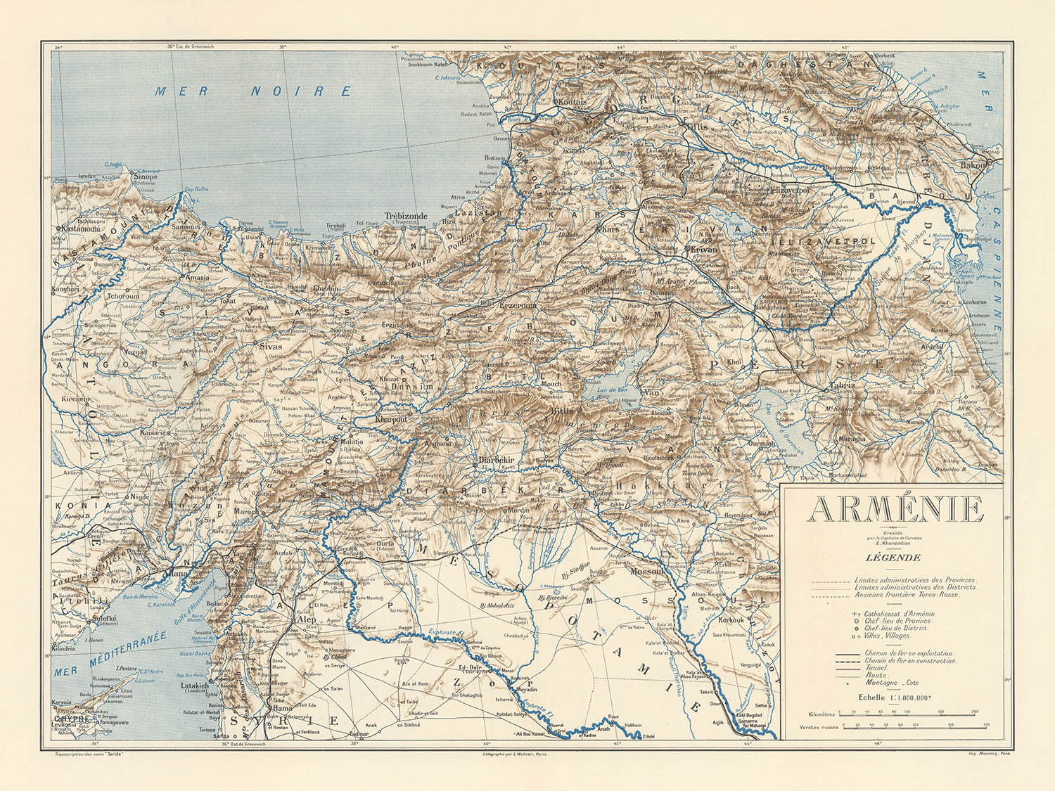
Step into a pivotal moment in world history with the “Carte de Arménie,” a masterwork of cartography crafted in 1919 by the renowned Armenian cartographer Zatik (Zadig) H. Khanzadian. This map, presented by the Armenian National Delegation at the Paris Peace Conference, stands as both a geographical document and a poignant testament to the enduring spirit of the Armenian people. With its intricate delineation of ancient and contemporary boundaries, it vividly captures the territorial aspirations of a nation seeking recognition and renewal after centuries of foreign domination and the profound tragedy of the Armenian Genocide.
Khanzadian, born in 1886 and educated at the esteemed Military-Naval School in Izmir, brought to his work a unique blend of military precision and deep cultural insight. His life’s journey—from Ottoman Anatolia to Bulgaria and ultimately Paris—mirrored the displacement and resilience of his people. At the Paris Peace Conference, his expertise in navigation and strategy found its highest expression in this map, which was meticulously designed to communicate Armenia’s historical claims and the urgent need for international support.
The “Carte de Arménie” is a rich tapestry of physical and political geography. It showcases the storied landscapes of the Armenian Highlands, with the majestic Mount Ararat rising as a symbol of national identity. The map’s careful rendering of Lake Van, Lake Sevan, and Lake Urmia, along with the sweeping contours of the Black Sea and Caspian Sea, anchors Armenia within its broader regional context. The inclusion of vital railroads and mountain ranges underscores the strategic importance of these lands, both as a crossroads of civilizations and as a homeland for generations of Armenians.
Cities and towns such as Yerevan, Van, Erzurum, Kars, and Bitlis are elegantly marked, their placement a reminder of the deep historical roots of Armenian civilization across modern-day Armenia, Turkey, Azerbaijan, and Iran. The map further highlights prominent church centers and monasteries, evoking the spiritual and cultural heritage that has shaped Armenian identity through the ages. These settlements, now vibrant urban centers or evocative historical sites, provide a living link to the past that is beautifully preserved in Khanzadian’s work.
Above all, this map is a testament to the hopes and struggles of a nation at a crossroads. It reflects the broader diplomatic and cultural efforts of Armenian leaders in the early twentieth century, who sought to educate Western policymakers and secure a future for their people. Khanzadian’s legacy, evident in this and his other celebrated works, is one of dedication, artistry, and historical vision—qualities that make the “Carte de Arménie” not only a collector’s treasure but also a window into the enduring quest for recognition and sovereignty.
Cities and towns on this map
- Turkey:
- Van
- Erzurum
- Kars
- Bitlis
- Armenia:
- Yerevan (Erevan)
- Gyumri (Alexandropol)
- Azerbaijan:
- Nakhchivan
- Iran:
- Urmia (Ourmia)
Notable Features & Landmarks
- Lake Van (Lac de Van)
- Lake Sevan (Lac de Sevan)
- Lake Urmia (Lac d'Ourmia)
- Black Sea (Mer Noire)
- Caspian Sea (Mer Caspienne)
- Mount Ararat (Mont Ararat)
- Clearly delineated historical and contemporary boundaries of Armenia
- Prominent monasteries and church centers
- Railway lines depicted, indicating transportation infrastructure
Historical and design context
- Created in 1919 by Zatik (Zadig) H. Khanzadian, a renowned Armenian cartographer
- Presented by the Armenian National Delegation at the Paris Peace Conference to advocate for Armenian territorial claims and sovereignty
- Reflects Armenian aspirations for national identity, independence, and territorial integrity after centuries of foreign domination and the Armenian Genocide
- Depicts historical and contemporary political boundaries, ancient Armenian kingdoms, and administrative divisions
- Part of a broader diplomatic effort to educate Western policymakers about Armenian historical claims and injustices
- Artistic and precise, combining historical and contemporary cartographic elements, reflecting Khanzadian’s military and navigational training
Please double check the images to make sure that a specific town or place is shown on this map. You can also get in touch and ask us to check the map for you.
This map looks great at every size, but I always recommend going for a larger size if you have space. That way you can easily make out all of the details.
This map looks amazing at sizes all the way up to 100in (250cm). If you are looking for a larger map, please get in touch.
The model in the listing images is holding the 18x24in (45x60cm) version of this map.
The fifth listing image shows an example of my map personalisation service.
If you’re looking for something slightly different, check out my collection of the best old maps to see if something else catches your eye.
Please contact me to check if a certain location, landmark or feature is shown on this map.
This would make a wonderful birthday, Christmas, Father's Day, work leaving, anniversary or housewarming gift for someone from the areas covered by this map.
This map is available as a giclée print on acid free archival matte paper, or you can buy it framed. The frame is a nice, simple black frame that suits most aesthetics. Please get in touch if you'd like a different frame colour or material. My frames are glazed with super-clear museum-grade acrylic (perspex/acrylite), which is significantly less reflective than glass, safer, and will always arrive in perfect condition.
This map is also available as a float framed canvas, sometimes known as a shadow gap framed canvas or canvas floater. The map is printed on artist's cotton canvas and then stretched over a handmade box frame. We then "float" the canvas inside a wooden frame, which is available in a range of colours (black, dark brown, oak, antique gold and white). This is a wonderful way to present a map without glazing in front. See some examples of float framed canvas maps and explore the differences between my different finishes.
For something truly unique, this map is also available in "Unique 3D", our trademarked process that dramatically transforms the map so that it has a wonderful sense of depth. We combine the original map with detailed topography and elevation data, so that mountains and the terrain really "pop". For more info and examples of 3D maps, check my Unique 3D page.
Many of our maps and art prints are chosen as thoughtful gifts for homes, offices, studies and meaningful places.
Choose a framed option for the easiest ready-to-hang gift, or choose an unframed print if the recipient may prefer to select their own frame.
We make orders locally in 23 countries around the world, so gifts can often be produced close to the recipient. This helps them arrive faster, travel more safely, and avoid customs or import duty surprises.
- We can deliver directly to the recipient
- Framed pieces arrive ready to hang
- Unframed prints are carefully packed in a strong protective tube
- Almost every order is made locally, for faster, safer gifting
- 90-day returns give the recipient time to decide
If you are not sure what to choose, please contact us. We can help you pick the right map, size, finish or delivery option.
Most orders are made locally and delivered in around 2–3 working days, depending on the product, size and destination.
We print and frame maps and artwork in 23 countries around the world, so your order is usually made close to you or your recipient. That means faster delivery, less time in transit, and no customs or import duty surprises.
Personalised and customised pieces usually take an extra 1–2 working days, because we prepare your design and send it to you for approval before printing.
Very large framed orders can take a little longer, as they need extra care in production and delivery.
Every order is carefully packaged: unframed prints are sent in a strong protective tube, while framed pieces are securely packed with protective materials around the frame.
If you need your order by a particular date, please contact us before ordering. We’ll check the best production route and delivery option for your location.
Express delivery is available at checkout for most countries. Next-day delivery is available in the UK, US, Singapore and the UAE.
Your order is covered by our 90-day returns policy and 10-year guarantee.
Our standard frame is a gallery-style black ash hardwood frame, with a simple, modern look. It is approximately 20mm (0.8in) wide. You can also view some lovely customer photos of framed maps and art.
We use super-clear acrylic glazing, also known as Perspex or Acrylite, instead of traditional glass. It is lighter, safer, and has lower reflectivity, giving the artwork a clearer, cleaner appearance.
Six standard frame colours are available at no extra cost: black, dark brown, dark grey, oak, white, and antique gold. Custom framing and mounting/matting is also available for customers looking for something more specific.
Most maps, art prints, and illustrations are also available as a framed canvas. We use matte cotton canvas, stretch it over a sustainably sourced wooden box frame, and then float the piece within a wooden outer frame. The finished result is beautifully presented, with no glazing between you and the artwork.
All frames are supplied ready to hang, with either string or brackets fitted to the back. Very large frames will include heavy-duty hanging plates and/or a mounting baton. If you have any questions, please get in touch.
We can also supply old maps and artwork on canvas, foam board, cotton rag, and other materials.
If you would prefer to frame your map or artwork yourself, please read our size guide before ordering.
My maps are extremely high quality reproductions of original maps.
I source original, rare maps from libraries, auction houses and private collections around the world, restore them at my London workshop, and then use specialist giclée inks and printers to create beautiful maps that look even better than the original.
My maps are printed on acid-free archival matte (not glossy) paper that feels very high quality and almost like card. In technical terms the paper weight/thickness is 10mil/200gsm. It's perfect for framing.
I print with Epson ultrachrome giclée UV fade resistant pigment inks - some of the best inks you can find.
I can also make maps on canvas, cotton rag and other exotic materials.
Learn more about The Unique Maps Co.
Map personalisation
If you're looking for the perfect anniversary or housewarming gift, I can personalise your map to make it truly unique. For example, I can add a short message, or highlight an important location, or add your family's coat of arms.
The options are almost infinite. Please see my map personalisation page for some wonderful examples of what's possible.
To order a personalised map, select "personalise your map" before adding it to your basket.
Get in touch if you're looking for more complex customisations and personalisations.
Map ageing
I have been asked hundreds of times over the years by customers if they could buy a map that looks even older.
Well, now you can, by selecting Aged before you add a map to your basket.
All the product photos you see on this page show the map in its Original form. This is what the map looks like today.
If you select Aged, I will age your map by hand, using a special and unique process developed through years of studying old maps, talking to researchers to understand the chemistry of aging paper, and of course... lots of practice!
If you're unsure, stick to the Original colour of the map. If you want something a bit darker and older looking, go for Aged.
If you are not happy with your order for any reason, contact me and I'll get it fixed ASAP, free of charge. Please see my returns and refund policy for more information.
I am very confident you will like your restored map or art print. I have been doing this since 1984. I'm a 5-star Etsy seller. I have sold tens of thousands of maps and art prints and have over 5,000 real 5-star reviews. My work has been featured in interior design magazines, on the BBC, and on the walls of dozens of 5-star hotels.
I use a unique process to restore maps and artwork that is massively time consuming and labour intensive. Hunting down the original maps and illustrations can take months. I use state of the art and eye-wateringly expensive technology to scan and restore them. As a result, I guarantee my maps and art prints are a cut above the rest. I stand by my products and will always make sure you're 100% happy with what you receive.
Almost all of my maps and art prints look amazing at large sizes (200cm, 6.5ft+) and I can frame and deliver them to you as well, via special oversized courier. Contact me to discuss your specific needs.
Or try searching for something!


