

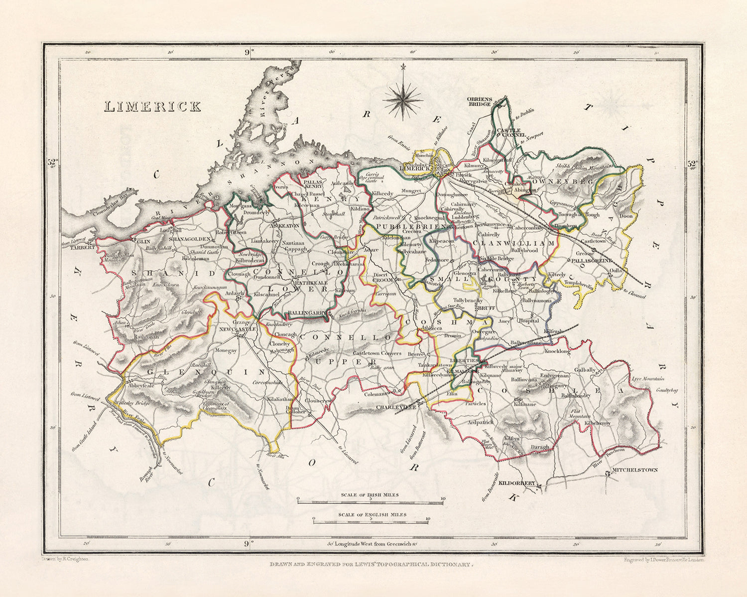


Rare Old Map of County Limerick by Samuel Lewis, 1844: Adare, Askeaton, Bruree, Croom, Kilmallock
20% off 2 — 33% off 3
Add any two eligible items to your bag to receive 20% off. Add a third and it will be complimentary (equivalent to 33% off when purchasing three).
No code needed — the offer applies automatically at checkout.
Valid on all standard maps and fine art prints. You can mix and match any designs.
If you’d like to ship items to multiple addresses, please contact us before placing your order.
Custom and bespoke commissions are excluded.
Contact us if you have any questions

Choose your size
Choose your finish


(More info)
Gift message & custom finish

If you want to add a gift message, or a finish (jigsaw, aluminium board, etc.) that is not available here, please request it in the "order note" when you check out.
Every order is custom made, so if you need the size adjusted slightly, or printed on an unusual material, just let us know. We've done thousands of custom orders over the years, so there's (almost) nothing we can't manage.
You can also contact us before you order, if you prefer!

- Made locally for fast, safe delivery
- No import duty or hidden fees
- Need advice? Message us on WhatsApp
Own a piece of history
7,000+ 5 star reviews


This Old Map of Limerick by Samuel Lewis, created in 1844, offers a captivating glimpse into the historical landscape of County Limerick, Ireland. With its intricate details and exquisite craftsmanship, this map is a true testament to the artistry of cartography.
Featuring the five main towns and cities of Adare, Askeaton, Bruree, Croom, and Kilmallock, this map showcases the rich history and cultural heritage of County Limerick. While some modern cities may not be depicted on this map, it provides an exciting opportunity to explore earlier names and settlements that once thrived within these historical boundaries.
Notable for its accuracy and attention to detail, this map allows you to immerse yourself in the past and discover the fascinating towns, cities, counties, settlements, and colonies that were founded before 1840 within County Limerick. Each settlement listed below carries its own historical significance, providing a captivating narrative of Ireland's past:
- Limerick City (812): The largest city in County Limerick, renowned for its medieval architecture and rich cultural heritage.
- Newcastle West (1197): A vibrant market town with a long history dating back to the 12th century.
- Abbeyfeale (1300s): A picturesque town known for its abbey ruins and charming rural landscapes.
- Rathkeale (1289): A historic market town with a strong Anglo-Norman influence.
- Kilmallock (1187): An ancient walled town boasting well-preserved medieval ruins and a turbulent past.
- Bruff (1200s): A quaint town steeped in history, featuring ancient castles and a strong agricultural heritage.
- Askeaton (1200s): A charming riverside town known for its impressive castle ruins and medieval history.
- Croom (1200s): A historic town with a rich medieval heritage, including a well-preserved castle.
- Adare (1200s): A picturesque village renowned for its thatched cottages and medieval architecture.
- Hospital (1200s): A small village with a long history, believed to have been named after a medieval hospice.
- Pallasgreen (1200s): A rural village with a deep-rooted history and scenic surroundings.
- Kilfinane (1200s): A tranquil town nestled in the Ballyhoura Mountains, known for its natural beauty and folklore.
- Glin (1200s): A coastal village boasting a medieval castle and stunning views of the Shannon Estuary.
- Murroe (1200s): A charming village surrounded by lush green landscapes and dotted with historical landmarks.
- Knocklong (1200s): A village steeped in folklore and history, famous for the Siege of Knocklong in 1642.
- Bruree (1200s): A small village with a rich archaeological heritage, including ancient ringforts and burial sites.
- Cappamore (1200s): A peaceful village known for its scenic beauty and traditional Irish charm.
- Foynes (1200s): A coastal village with a history intertwined with aviation, once a major seaplane base.
- Ballylanders (1200s): A rural village nestled in the Galtee Mountains, offering breathtaking natural landscapes.
- Kilmeedy (1200s): A tranquil village with a strong community spirit and a rich historical tapestry.
- Kilcornan (1200s): A picturesque village situated on the banks of the River Shannon, known for its natural beauty.
- Shanagolden (1200s): A historic village with a fascinating past, including connections to the Knights Templar.
- Castleconnell (1200s): A charming village renowned for its picturesque riverside setting and castle ruins.
- Pallaskenry (1200s): A village steeped in history, featuring a well-preserved medieval church.
- Athea (1200s): A quaint village with a strong sense of community and a rich agricultural heritage.
- Mountcollins (1200s): A rural village surrounded by rolling hills and scenic landscapes.
- Clarina (1200s): A peaceful village known for its idyllic countryside and charming rural atmosphere.
- Abbeyfeale (1200s): A historic town with a strong connection to the Franciscan order, featuring an abbey.
- Ballyneety (1200s): A village with a rich equestrian history, known for its horse racing and equestrian facilities.
- Kilfinny (1200s): A small village with a strong agricultural tradition and a close-knit community.
- Adare (1200s): A picturesque village renowned for its thatched cottages and medieval architecture.
County Limerick is also blessed with natural wonders and historical landmarks that continue to captivate visitors to this day. Some notable attractions include the majestic River Shannon, the awe-inspiring Shannon Estuary, the enchanting Ballyhoura Mountains, and the scenic Galtee Mountains. These natural phenomena and historic boundaries provide a breathtaking backdrop to the rich tapestry of County Limerick's past.
Between 1800 and 1850, County Limerick witnessed several significant historical events. These included the Irish Rebellion of 1803 led by Robert Emmet, the Great Famine of 1845-1852, and the rise of the Young Ireland movement advocating for Irish independence. These events shaped the region's history and left an indelible mark on the people and landscape of County Limerick.
Owning this Old Map of Limerick by Samuel Lewis, created in 1844, allows you to delve into the past and appreciate the historical significance of County Limerick, Ireland. With its meticulous detail and rich historical context, this map is a treasured piece for any history enthusiast or lover of fine cartography.
Please double check the images to make sure that a specific town or place is shown on this map. You can also get in touch and ask us to check the map for you.
This map looks great at all sizes, but it looks even better when printed large.
I can create beautiful, large prints of this map up to 50in (127cm). Please get in touch if you're looking for larger, customised or different framing options.
The model in the listing images is holding the 16x20in (40.5x51cm) version of this map.
The fifth listing image shows an example of my map personalisation service.
If you’re looking for something slightly different, check out my main collection of UK and Ireland maps.
Please contact me to check if a certain location, landmark or feature is shown on this map.
This would make a wonderful birthday, Christmas, Father's Day, work leaving, anniversary or housewarming gift for someone from the areas covered by this map.
This map is available as a giclée print on acid free archival matte paper, or you can buy it framed. The frame is a nice, simple black frame that suits most aesthetics. Please get in touch if you'd like a different frame colour or material. My frames are glazed with super-clear museum-grade acrylic (perspex/acrylite), which is significantly less reflective than glass, safer, and will always arrive in perfect condition.
This map is also available as a float framed canvas, sometimes known as a shadow gap framed canvas or canvas floater. The map is printed on artist's cotton canvas and then stretched over a handmade box frame. We then "float" the canvas inside a wooden frame, which is available in a range of colours (black, dark brown, oak, antique gold and white). This is a wonderful way to present a map without glazing in front. See some examples of float framed canvas maps and explore the differences between my different finishes.
For something truly unique, this map is also available in "Unique 3D", our trademarked process that dramatically transforms the map so that it has a wonderful sense of depth. We combine the original map with detailed topography and elevation data, so that mountains and the terrain really "pop". For more info and examples of 3D maps, check my Unique 3D page.
Many of our maps and art prints are chosen as thoughtful gifts for homes, offices, studies and meaningful places.
Choose a framed option for the easiest ready-to-hang gift, or choose an unframed print if the recipient may prefer to select their own frame.
We make orders locally in 23 countries around the world, so gifts can often be produced close to the recipient. This helps them arrive faster, travel more safely, and avoid customs or import duty surprises.
- We can deliver directly to the recipient
- Framed pieces arrive ready to hang
- Unframed prints are carefully packed in a strong protective tube
- Almost every order is made locally, for faster, safer gifting
- 90-day returns give the recipient time to decide
If you are not sure what to choose, please contact us. We can help you pick the right map, size, finish or delivery option.
Most orders are made locally and delivered in around 2–3 working days, depending on the product, size and destination.
We print and frame maps and artwork in 23 countries around the world, so your order is usually made close to you or your recipient. That means faster delivery, less time in transit, and no customs or import duty surprises.
Personalised and customised pieces usually take an extra 1–2 working days, because we prepare your design and send it to you for approval before printing.
Very large framed orders can take a little longer, as they need extra care in production and delivery.
Every order is carefully packaged: unframed prints are sent in a strong protective tube, while framed pieces are securely packed with protective materials around the frame.
If you need your order by a particular date, please contact us before ordering. We’ll check the best production route and delivery option for your location.
Express delivery is available at checkout for most countries. Next-day delivery is available in the UK, US, Singapore and the UAE.
Your order is covered by our 90-day returns policy and 10-year guarantee.
Our standard frame is a gallery-style black ash hardwood frame, with a simple, modern look. It is approximately 20mm (0.8in) wide. You can also view some lovely customer photos of framed maps and art.
We use super-clear acrylic glazing, also known as Perspex or Acrylite, instead of traditional glass. It is lighter, safer, and has lower reflectivity, giving the artwork a clearer, cleaner appearance.
Six standard frame colours are available at no extra cost: black, dark brown, dark grey, oak, white, and antique gold. Custom framing and mounting/matting is also available for customers looking for something more specific.
Most maps, art prints, and illustrations are also available as a framed canvas. We use matte cotton canvas, stretch it over a sustainably sourced wooden box frame, and then float the piece within a wooden outer frame. The finished result is beautifully presented, with no glazing between you and the artwork.
All frames are supplied ready to hang, with either string or brackets fitted to the back. Very large frames will include heavy-duty hanging plates and/or a mounting baton. If you have any questions, please get in touch.
We can also supply old maps and artwork on canvas, foam board, cotton rag, and other materials.
If you would prefer to frame your map or artwork yourself, please read our size guide before ordering.
My maps are extremely high quality reproductions of original maps.
I source original, rare maps from libraries, auction houses and private collections around the world, restore them at my London workshop, and then use specialist giclée inks and printers to create beautiful maps that look even better than the original.
My maps are printed on acid-free archival matte (not glossy) paper that feels very high quality and almost like card. In technical terms the paper weight/thickness is 10mil/200gsm. It's perfect for framing.
I print with Epson ultrachrome giclée UV fade resistant pigment inks - some of the best inks you can find.
I can also make maps on canvas, cotton rag and other exotic materials.
Learn more about The Unique Maps Co.
Map personalisation
If you're looking for the perfect anniversary or housewarming gift, I can personalise your map to make it truly unique. For example, I can add a short message, or highlight an important location, or add your family's coat of arms.
The options are almost infinite. Please see my map personalisation page for some wonderful examples of what's possible.
To order a personalised map, select "personalise your map" before adding it to your basket.
Get in touch if you're looking for more complex customisations and personalisations.
Map ageing
I have been asked hundreds of times over the years by customers if they could buy a map that looks even older.
Well, now you can, by selecting Aged before you add a map to your basket.
All the product photos you see on this page show the map in its Original form. This is what the map looks like today.
If you select Aged, I will age your map by hand, using a special and unique process developed through years of studying old maps, talking to researchers to understand the chemistry of aging paper, and of course... lots of practice!
If you're unsure, stick to the Original colour of the map. If you want something a bit darker and older looking, go for Aged.
If you are not happy with your order for any reason, contact me and I'll get it fixed ASAP, free of charge. Please see my returns and refund policy for more information.
I am very confident you will like your restored map or art print. I have been doing this since 1984. I'm a 5-star Etsy seller. I have sold tens of thousands of maps and art prints and have over 5,000 real 5-star reviews. My work has been featured in interior design magazines, on the BBC, and on the walls of dozens of 5-star hotels.
I use a unique process to restore maps and artwork that is massively time consuming and labour intensive. Hunting down the original maps and illustrations can take months. I use state of the art and eye-wateringly expensive technology to scan and restore them. As a result, I guarantee my maps and art prints are a cut above the rest. I stand by my products and will always make sure you're 100% happy with what you receive.
Almost all of my maps and art prints look amazing at large sizes (200cm, 6.5ft+) and I can frame and deliver them to you as well, via special oversized courier. Contact me to discuss your specific needs.
Or try searching for something!


