


Rare Old Naval Map of Cadiz by Waghenaer, 1583: Strait of Gibraltar, Cadiz, Lisbon, Sea Monsters, Sailing Ships
The Collector’s Offer
Choose two eligible works and receive 20% off both. Choose three and the lowest-priced one is complimentary, a maximum saving of 33%.
Mix and match eligible standard maps and fine-art prints. No code is required; the offer is applied automatically at checkout.
Standard made-to-order configurations are included. Bespoke sizes, personalised designs and commissioned work are excluded.
Need delivery to different addresses? Contact us before ordering.The Collector’s Offer
Choose two eligible works and receive 20% off both. Choose three and the lowest-priced one is complimentary, a maximum saving of 33%.
Mix and match eligible standard maps and fine-art prints. No code is required; the offer is applied automatically at checkout.
Standard made-to-order configurations are included. Bespoke sizes, personalised designs and commissioned work are excluded.
Need delivery to different addresses? Contact us before ordering.
Restored from the original 1583 map and printed to museum-grade archival standards. Read the story behind this map
Choose your size
Choose your finish


(More info)
Gift message & custom finish

If you want to add a gift message, or a finish (jigsaw, aluminium board, etc.) that is not available here, please request it in the "order note" when you check out.
Every order is custom made, so if you need the size adjusted slightly, or printed on an unusual material, just let us know. We've done thousands of custom orders over the years, so there's (almost) nothing we can't manage.
You can also contact us before you order, if you prefer!

- Made locally for fast, safe delivery
- No import duty or hidden fees
- Need advice? Call us or message on WhatsApp
Own a piece of history
8,000+ five-star reviews


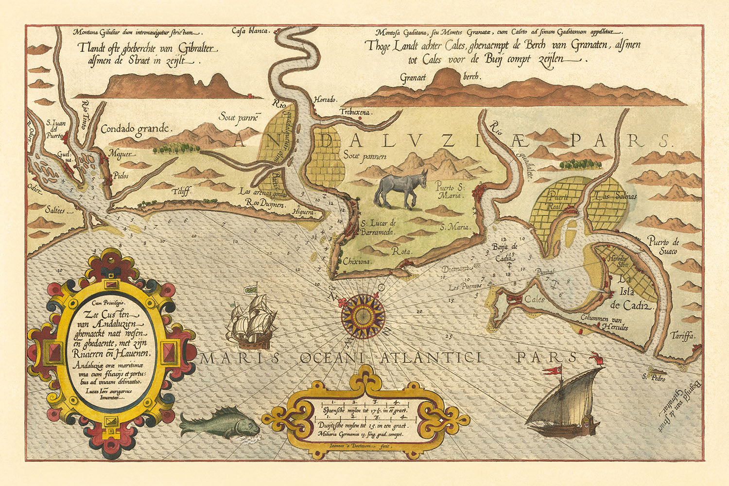
Embark on a historical voyage with the "Zee Custen van Andaluzien ghemaeckt naet wesen en ghedaente, met zijn Rivieren en Hauenen," a...
Continue readingEmbark on a historical voyage with the "Zee Custen van Andaluzien ghemaeckt naet wesen en ghedaente, met zijn Rivieren en Hauenen," a breathtaking map crafted in 1583 by the renowned Dutch cartographer Lucas Janszoon Waghenaer. This exquisite piece is not merely a navigational tool but a window into the Age of Discovery, capturing the southwestern coast of Spain in unparalleled detail. From the bustling Bay of Cadiz to the strategic Strait of Gibraltar at the map's zenith, every inch of this chart is a testament to the era's navigational prowess and the allure of Andalusia's coast. The inclusion of the cities of Cadiz and Sevilla, along with the unmarked neighborhoods of Lisbon, offers a unique glimpse into the urban and maritime landscape of the 16th century, making it a fascinating piece for enthusiasts of urban cartography.
Waghenaer, a pioneer in the field of nautical charting, presents us with the "Spiegel der Zeevaerdt," the first in a series of effective navigational charts that revolutionized maritime exploration. His work is not only significant for its technical accuracy but also for its artistic merit. The map is adorned with vibrant colors, two decorative cartouches, and detailed illustrations that include a pair of majestic sailing ships, a compass rose, and even mythical sea monsters lurking in the waters near the Iberian Peninsula. These elements not only add to the map's visual appeal but also reflect the period's blend of knowledge and mythology, making it a captivating piece for collectors and historians alike.
The strategic importance of the depicted regions cannot be overstated. The Strait of Gibraltar, prominently featured at the top of the map, has been a critical maritime passage for centuries, serving as the gateway between the Mediterranean Sea and the Atlantic Ocean. The cities of Cadiz and Sevilla, with their rich histories of trade and exploration, are intricately rendered, offering insights into their significance during a time when Spain was at the height of its global power. The absence of detailed neighborhoods in Lisbon highlights the map's focus on coastal and navigational features, yet it invites the viewer to ponder the unseen intricacies of these historic cities.
Waghenaer's mastery is further evidenced by the inclusion of soundings and anchorages, crucial details for the seafarers of his time. These annotations, alongside the profiles of the coastline, demonstrate an advanced understanding of the region's maritime geography, making this map an indispensable tool for navigators. The presence of a small world map and a detailed depiction of the Iberian Peninsula serve as reminders of the broader context of exploration and conquest in which this chart was created, linking local maritime knowledge with global ambitions.
In conclusion, Lucas Janszoon Waghenaer's map is more than a navigational aid; it is a masterpiece of Renaissance cartography and a symbol of the era's thirst for exploration. Its detailed portrayal of significant landmarks, rivers, and coastal profiles, combined with the artistic flourishes that capture the imagination, make it an essential acquisition for collectors and aficionados of historical maps. As the earliest decorative sea chart of the region, it not only marks a pivotal moment in the history of cartography but also serves as a lasting tribute to the maritime heritage of Spain, Portugal, and Morocco.
I'm sorry for any confusion, but it appears there was a misunderstanding in the request. The original information provided about the map did not include specific sections titled "Streets and roads on this map" or similar headings directly related to streets, roads, notable features, or historical and design context in a bulleted format. However, based on the detailed description provided earlier, I can extract and organize relevant information into the requested bullet point format under the specified headlines.
Notable Features & Landmarks
- Illustrations:
- There is a ship illustration in the bottom right corner of the map.
- There is a compass rose in the center of the map.
- There are two sea monsters in the ocean near the bottom of the map.
- Landmarks:
- The Strait of Gibraltar is located at the top of the map.
- The city of Cadiz is located on the southern coast of Spain.
- The city of Lisbon is located on the western coast of Portugal.
Historical and design context
- Title: Zee Custen van Andaluzien ghemaeckt naet wesen en ghedaente, met zijn Rivieren en Hauenen
- Date: 1583
- Mapmaker: Lucas Janszoon Waghenaer
- Striking full color example of Wagenhaer's map of the southwestern coast of Spain, including the Bay of Cadiz.
- Extends inland to Sevilla and south to Cadiz, with northeast at the top of the map.
- Includes a sea monster, 2 sailing ships, a compass rose, and 2 decorative cartouches, soundings, and anchorages. Profiles of the coastline are shown.
- Wagenhaer was a Dutch pilot who produced the first set of effective navigational charts, under the title Spiegel der Zeevaerdt. These charts set the standard for sea charts for more than a century.
- An essential map for collectors of the region and the earliest decorative sea chart of the region.
- Design and style: Hand-drawn, colored, decorative, sea chart.
- Historical significance: One of the first accurate sea charts, highly sought after by collectors.
This structured approach allows for a quick overview of the map's key aspects, from its notable features and landmarks to the historical and design context that makes it a valuable collector's item.
Please double check the images to make sure that a specific town or place is shown on this map. You can also get in touch and ask us to check the map for you.
This map looks great at every size, but I always recommend going for a larger size if you have space. That way you can easily make out all of the details.
This map looks amazing at sizes all the way up to 90in (230cm). If you are looking for a larger map, please get in touch.
The model in the listing images is holding the 24x36in (60x90cm) version of this map.
The fifth listing image shows an example of my map personalisation service.
If you’re looking for something slightly different, check out my collection of the best old maps to see if something else catches your eye.
Please contact me to check if a certain location, landmark or feature is shown on this map.
This would make a wonderful birthday, Christmas, Father's Day, work leaving, anniversary or housewarming gift for someone from the areas covered by this map.
This map is available as a giclée print on acid free archival matte paper, or you can buy it framed. The frame is a nice, simple black frame that suits most aesthetics. Please get in touch if you'd like a different frame colour or material. My frames are glazed with super-clear museum-grade acrylic (perspex/acrylite), which is significantly less reflective than glass, safer, and will always arrive in perfect condition.
This map is also available as a float framed canvas, sometimes known as a shadow gap framed canvas or canvas floater. The map is printed on artist's cotton canvas and then stretched over a handmade box frame. We then "float" the canvas inside a wooden frame, which is available in a range of colours (black, dark brown, oak, antique gold and white). This is a wonderful way to present a map without glazing in front. See some examples of float framed canvas maps and explore the differences between my different finishes.
For something truly unique, this map is also available in "Unique 3D", our trademarked process that dramatically transforms the map so that it has a wonderful sense of depth. We combine the original map with detailed topography and elevation data, so that mountains and the terrain really "pop". For more info and examples of 3D maps, check my Unique 3D page.
Embark on a historical voyage with the "Zee Custen van Andaluzien ghemaeckt naet wesen en ghedaente, met zijn Rivieren en Hauenen," a breathtaking map crafted in 1583 by the renowned Dutch cartographer Lucas Janszoon Waghenaer. This exquisite piece is not merely a navigational tool but a window into the Age of Discovery, capturing the southwestern coast of Spain in unparalleled detail. From the bustling Bay of Cadiz to the strategic Strait of Gibraltar at the map's zenith, every inch of this chart is a testament to the era's navigational prowess and the allure of Andalusia's coast. The inclusion of the cities of Cadiz and Sevilla, along with the unmarked neighborhoods of Lisbon, offers a unique glimpse into the urban and maritime landscape of the 16th century, making it a fascinating piece for enthusiasts of urban cartography.
Waghenaer, a pioneer in the field of nautical charting, presents us with the "Spiegel der Zeevaerdt," the first in a series of effective navigational charts that revolutionized maritime exploration. His work is not only significant for its technical accuracy but also for its artistic merit. The map is adorned with vibrant colors, two decorative cartouches, and detailed illustrations that include a pair of majestic sailing ships, a compass rose, and even mythical sea monsters lurking in the waters near the Iberian Peninsula. These elements not only add to the map's visual appeal but also reflect the period's blend of knowledge and mythology, making it a captivating piece for collectors and historians alike.
The strategic importance of the depicted regions cannot be overstated. The Strait of Gibraltar, prominently featured at the top of the map, has been a critical maritime passage for centuries, serving as the gateway between the Mediterranean Sea and the Atlantic Ocean. The cities of Cadiz and Sevilla, with their rich histories of trade and exploration, are intricately rendered, offering insights into their significance during a time when Spain was at the height of its global power. The absence of detailed neighborhoods in Lisbon highlights the map's focus on coastal and navigational features, yet it invites the viewer to ponder the unseen intricacies of these historic cities.
Waghenaer's mastery is further evidenced by the inclusion of soundings and anchorages, crucial details for the seafarers of his time. These annotations, alongside the profiles of the coastline, demonstrate an advanced understanding of the region's maritime geography, making this map an indispensable tool for navigators. The presence of a small world map and a detailed depiction of the Iberian Peninsula serve as reminders of the broader context of exploration and conquest in which this chart was created, linking local maritime knowledge with global ambitions.
In conclusion, Lucas Janszoon Waghenaer's map is more than a navigational aid; it is a masterpiece of Renaissance cartography and a symbol of the era's thirst for exploration. Its detailed portrayal of significant landmarks, rivers, and coastal profiles, combined with the artistic flourishes that capture the imagination, make it an essential acquisition for collectors and aficionados of historical maps. As the earliest decorative sea chart of the region, it not only marks a pivotal moment in the history of cartography but also serves as a lasting tribute to the maritime heritage of Spain, Portugal, and Morocco.
I'm sorry for any confusion, but it appears there was a misunderstanding in the request. The original information provided about the map did not include specific sections titled "Streets and roads on this map" or similar headings directly related to streets, roads, notable features, or historical and design context in a bulleted format. However, based on the detailed description provided earlier, I can extract and organize relevant information into the requested bullet point format under the specified headlines.
Notable Features & Landmarks
- Illustrations:
- There is a ship illustration in the bottom right corner of the map.
- There is a compass rose in the center of the map.
- There are two sea monsters in the ocean near the bottom of the map.
- Landmarks:
- The Strait of Gibraltar is located at the top of the map.
- The city of Cadiz is located on the southern coast of Spain.
- The city of Lisbon is located on the western coast of Portugal.
Historical and design context
- Title: Zee Custen van Andaluzien ghemaeckt naet wesen en ghedaente, met zijn Rivieren en Hauenen
- Date: 1583
- Mapmaker: Lucas Janszoon Waghenaer
- Striking full color example of Wagenhaer's map of the southwestern coast of Spain, including the Bay of Cadiz.
- Extends inland to Sevilla and south to Cadiz, with northeast at the top of the map.
- Includes a sea monster, 2 sailing ships, a compass rose, and 2 decorative cartouches, soundings, and anchorages. Profiles of the coastline are shown.
- Wagenhaer was a Dutch pilot who produced the first set of effective navigational charts, under the title Spiegel der Zeevaerdt. These charts set the standard for sea charts for more than a century.
- An essential map for collectors of the region and the earliest decorative sea chart of the region.
- Design and style: Hand-drawn, colored, decorative, sea chart.
- Historical significance: One of the first accurate sea charts, highly sought after by collectors.
This structured approach allows for a quick overview of the map's key aspects, from its notable features and landmarks to the historical and design context that makes it a valuable collector's item.
Please double check the images to make sure that a specific town or place is shown on this map. You can also get in touch and ask us to check the map for you.
This map looks great at every size, but I always recommend going for a larger size if you have space. That way you can easily make out all of the details.
This map looks amazing at sizes all the way up to 90in (230cm). If you are looking for a larger map, please get in touch.
The model in the listing images is holding the 24x36in (60x90cm) version of this map.
The fifth listing image shows an example of my map personalisation service.
If you’re looking for something slightly different, check out my collection of the best old maps to see if something else catches your eye.
Please contact me to check if a certain location, landmark or feature is shown on this map.
This would make a wonderful birthday, Christmas, Father's Day, work leaving, anniversary or housewarming gift for someone from the areas covered by this map.
This map is available as a giclée print on acid free archival matte paper, or you can buy it framed. The frame is a nice, simple black frame that suits most aesthetics. Please get in touch if you'd like a different frame colour or material. My frames are glazed with super-clear museum-grade acrylic (perspex/acrylite), which is significantly less reflective than glass, safer, and will always arrive in perfect condition.
This map is also available as a float framed canvas, sometimes known as a shadow gap framed canvas or canvas floater. The map is printed on artist's cotton canvas and then stretched over a handmade box frame. We then "float" the canvas inside a wooden frame, which is available in a range of colours (black, dark brown, oak, antique gold and white). This is a wonderful way to present a map without glazing in front. See some examples of float framed canvas maps and explore the differences between my different finishes.
For something truly unique, this map is also available in "Unique 3D", our trademarked process that dramatically transforms the map so that it has a wonderful sense of depth. We combine the original map with detailed topography and elevation data, so that mountains and the terrain really "pop". For more info and examples of 3D maps, check my Unique 3D page.
Many of our maps and art prints are chosen as thoughtful gifts for homes, offices, studies and meaningful places.
Choose a framed option for the easiest ready-to-hang gift, or choose an unframed print if the recipient may prefer to select their own frame.
We make orders locally in 23 countries around the world, so gifts can often be produced close to the recipient. This helps them arrive faster, travel more safely, and avoid customs or import duty surprises.
- We can deliver directly to the recipient
- Framed pieces arrive ready to hang
- Unframed prints are carefully packed in a strong protective tube
- Almost every order is made locally, for faster, safer gifting
- 90-day returns give the recipient time to decide
If you are not sure what to choose, please contact us. We can help you pick the right map, size, finish or delivery option.
Most orders are made locally and delivered in around 2–3 working days, depending on the product, size and destination.
We print and frame maps and artwork in 23 countries around the world, so your order is usually made close to you or your recipient. That means faster delivery, less time in transit, and no customs or import duty surprises.
Personalised and customised pieces usually take an extra 1–2 working days, because we prepare your design and send it to you for approval before printing.
Very large framed orders can take a little longer, as they need extra care in production and delivery.
Every order is carefully packaged: unframed prints are sent in a strong protective tube, while framed pieces are securely packed with protective materials around the frame.
If you need your order by a particular date, please contact us before ordering. We’ll check the best production route and delivery option for your location.
Express delivery is available at checkout for most countries. Next-day delivery is available in the UK, US, Singapore and the UAE.
Your order is covered by our 90-day returns policy and 10-year guarantee.
Our standard frame is a gallery-style black ash hardwood frame, with a simple, modern look. It is approximately 20mm (0.8in) wide. You can also view some lovely customer photos of framed maps and art.
We use super-clear acrylic glazing, also known as Perspex or Acrylite, instead of traditional glass. It is lighter, safer, and has lower reflectivity, giving the artwork a clearer, cleaner appearance.
Six standard frame colours are available at no extra cost: black, dark brown, dark grey, oak, white, and antique gold. Custom framing and mounting/matting is also available for customers looking for something more specific.
Most maps, art prints, and illustrations are also available as a framed canvas. We use matte cotton canvas, stretch it over a sustainably sourced wooden box frame, and then float the piece within a wooden outer frame. The finished result is beautifully presented, with no glazing between you and the artwork.
All frames are supplied ready to hang, with either string or brackets fitted to the back. Very large frames will include heavy-duty hanging plates and/or a mounting baton. If you have any questions, please get in touch.
We can also supply old maps and artwork on canvas, foam board, cotton rag, and other materials.
If you would prefer to frame your map or artwork yourself, please read our size guide before ordering.
My maps are extremely high quality reproductions of original maps.
I source original, rare maps from libraries, auction houses and private collections around the world, restore them at my London workshop, and then use specialist giclée inks and printers to create beautiful maps that look even better than the original.
My maps are printed on acid-free archival matte (not glossy) paper that feels very high quality and almost like card. In technical terms the paper weight/thickness is 10mil/200gsm. It's perfect for framing.
I print with Epson ultrachrome giclée UV fade resistant pigment inks - some of the best inks you can find.
I can also make maps on canvas, cotton rag and other exotic materials.
Learn more about The Unique Maps Co.
Map personalisation
If you're looking for the perfect anniversary or housewarming gift, I can personalise your map to make it truly unique. For example, I can add a short message, or highlight an important location, or add your family's coat of arms.
The options are almost infinite. Please see my map personalisation page for some wonderful examples of what's possible.
To order a personalised map, select "personalise your map" before adding it to your basket.
Get in touch if you're looking for more complex customisations and personalisations.
Map ageing
I have been asked hundreds of times over the years by customers if they could buy a map that looks even older.
Well, now you can, by selecting Aged before you add a map to your basket.
All the product photos you see on this page show the map in its Original form. This is what the map looks like today.
If you select Aged, I will age your map by hand, using a special and unique process developed through years of studying old maps, talking to researchers to understand the chemistry of aging paper, and of course... lots of practice!
If you're unsure, stick to the Original colour of the map. If you want something a bit darker and older looking, go for Aged.
If you are not happy with your order for any reason, contact me and I'll get it fixed ASAP, free of charge. Please see my returns and refund policy for more information.
I am very confident you will like your restored map or art print. I have been doing this since 1984. I'm a 5-star Etsy seller. I have sold tens of thousands of maps and art prints and have over 5,000 real 5-star reviews. My work has been featured in interior design magazines, on the BBC, and on the walls of dozens of 5-star hotels.
I use a unique process to restore maps and artwork that is massively time consuming and labour intensive. Hunting down the original maps and illustrations can take months. I use state of the art and eye-wateringly expensive technology to scan and restore them. As a result, I guarantee my maps and art prints are a cut above the rest. I stand by my products and will always make sure you're 100% happy with what you receive.
Almost all of my maps and art prints look amazing at large sizes (200cm, 6.5ft+) and I can frame and deliver them to you as well, via special oversized courier. Contact me to discuss your specific needs.
Or try searching for something!


