


Pictorial Map of Alaska by Ruth Taylor White, 1935: Anchorage, Fairbanks, Yukon River, Glaciers, Aleutians
The Collector’s Offer
Choose two eligible works and receive 20% off both. Choose three and the lowest-priced one is complimentary, a maximum saving of 33%.
Mix and match eligible standard maps and fine-art prints. No code is required; the offer is applied automatically at checkout.
Standard made-to-order configurations are included. Bespoke sizes, personalised designs and commissioned work are excluded.
Need delivery to different addresses? Contact us before ordering.The Collector’s Offer
Choose two eligible works and receive 20% off both. Choose three and the lowest-priced one is complimentary, a maximum saving of 33%.
Mix and match eligible standard maps and fine-art prints. No code is required; the offer is applied automatically at checkout.
Standard made-to-order configurations are included. Bespoke sizes, personalised designs and commissioned work are excluded.
Need delivery to different addresses? Contact us before ordering.
Restored from the original 1935 map and printed to museum-grade archival standards. Read the story behind this map
Choose your size
Choose your finish


(More info)
Gift message & custom finish

If you want to add a gift message, or a finish (jigsaw, aluminium board, etc.) that is not available here, please request it in the "order note" when you check out.
Every order is custom made, so if you need the size adjusted slightly, or printed on an unusual material, just let us know. We've done thousands of custom orders over the years, so there's (almost) nothing we can't manage.
You can also contact us before you order, if you prefer!

- Made locally for fast, safe delivery
- No import duty or hidden fees
- Need advice? Call us or message on WhatsApp
Own a piece of history
8,000+ five-star reviews


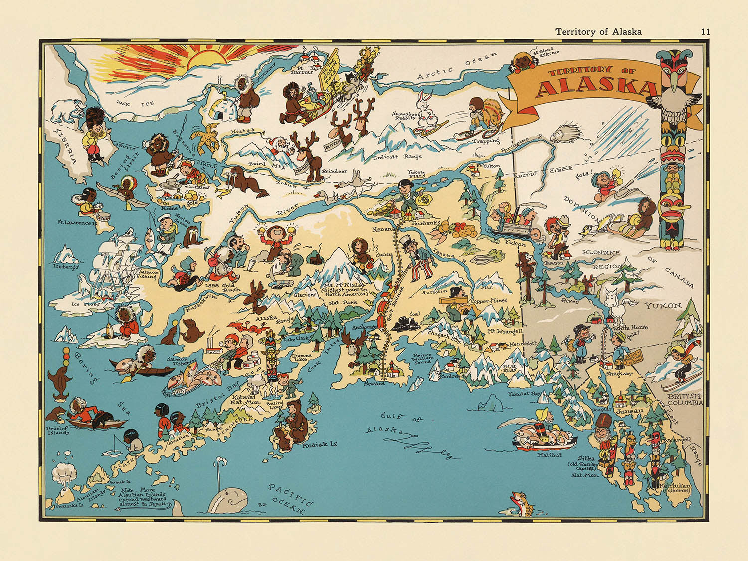
Step into the vibrant world of 1930s Alaska with Ruth Taylor White’s captivating pictorial map, originally titled “Territory of Alaska.” Created in...
Continue readingStep into the vibrant world of 1930s Alaska with Ruth Taylor White’s captivating pictorial map, originally titled “Territory of Alaska.” Created in 1935, this map is a masterful blend of cartographic precision and whimsical artistry, offering a unique window into the cultural and geographical imagination of pre-statehood Alaska. The hand-drawn illustrations burst with color and life, transforming the vast northern wilderness into a lively tableau of discovery and adventure. This map is not merely a record of place—it is a visual celebration of Alaska’s untamed spirit and enduring allure.
Ruth Taylor White, renowned for her distinctive pictorial maps, brings her characteristic flair to this piece. Her style is instantly recognizable: bold, playful, and deeply evocative of the era’s fascination with distant American frontiers. White’s maps were often featured in popular atlases of the time, and her work is prized for its ability to blend entertainment with education. Here, her illustrations capture the essence of Alaska’s cultural and natural heritage, from indigenous traditions to the promise of gold rush fortunes, all rendered with an affectionate and engaging touch.
The map’s design is a feast for the eyes, alive with scenes that encapsulate the period’s perception of Alaska. Indigenous peoples are depicted in traditional activities, surrounded by totem poles and wildlife such as bears, moose, and whales. The Yukon River snakes across the territory, while glaciers and snow-capped mountains rise majestically, reinforcing Alaska’s reputation as a land of dramatic landscapes and natural wonder. The Bering Sea and Arctic Ocean are boldly labeled, framing the territory’s remote and rugged coastline.
A closer look reveals a tapestry of human endeavor and natural phenomena. Gold mining camps, fishing boats, and dog sled teams dot the map, reflecting the industries and lifestyles that defined Alaska in the early twentieth century. The Arctic Circle is marked, underscoring the territory’s unique position at the edge of the known world. The Aleutian Islands stretch westward, and the international boundary with Canada is clearly delineated, emphasizing Alaska’s geopolitical significance long before statehood.
Anchorage, Fairbanks, Juneau, and other historic settlements are thoughtfully included, each rendered with the same lively attention to detail as the surrounding wilderness. These towns, many of which have grown into thriving modern cities, serve as touchstones for Alaska’s evolving story. The map’s decorative border and ornate title cartouche complete the composition, making this piece not only a cartographic artifact but also a work of art—one that invites viewers to explore, imagine, and appreciate the rich tapestry of Alaska’s past.
Cities and towns on this map
- Anchorage
- Fairbanks
- Juneau
- Nome
- Sitka
- Ketchikan
- Cordova
- Seward
- Valdez
- Wrangell
- Skagway
- Kodiak
Notable Features & Landmarks
- Illustrations of indigenous Alaskan peoples and their traditional activities
- Drawings of wildlife such as bears, moose, and whales
- Depictions of fishing and hunting scenes
- Illustrations of gold mining and prospecting, reflecting Alaska's gold rush history
- Scenes of dog sledding and traditional transportation
- Images of totem poles, representing indigenous art and culture
- Representation of glaciers and snow-capped mountains
- Artistic renderings of forests and rivers
- The Bering Sea and Arctic Ocean are labeled
- The Aleutian Islands are depicted and labeled
- The Yukon River is illustrated and labeled
- The Arctic Circle is marked on the map
- The map includes a decorative title cartouche with the map's name
- The map shows the international boundary with Canada
- The map is bordered with a decorative frame in keeping with the pictorial style
Historical and design context
- Created in 1935, when Alaska was still a U.S. territory, providing insight into contemporary American perceptions before statehood
- Mapmaker: Ruth Taylor White, known for her vibrant and whimsical pictorial maps
- Part of a pictorial or cartoon atlas of the United States, blending entertainment with education
- Features a colorful, cartoonish design with hand-drawn illustrations
- Reflects the stereotypes and artistic conventions of the era, offering a visual snapshot of 1930s Alaska
- Intended more for educational and entertainment purposes than for precise navigation
Please double check the images to make sure that a specific town or place is shown on this map. You can also get in touch and ask us to check the map for you.
This map looks great at every size, but I always recommend going for a larger size if you have space. That way you can easily make out all of the details.
This map looks amazing at sizes all the way up to 50in (125cm). If you are looking for a larger map, please get in touch.
The model in the listing images is holding the 18x24in (45x60cm) version of this map.
The fifth listing image shows an example of my map personalisation service.
If you’re looking for something slightly different, check out my collection of the best old maps to see if something else catches your eye.
Please contact me to check if a certain location, landmark or feature is shown on this map.
This would make a wonderful birthday, Christmas, Father's Day, work leaving, anniversary or housewarming gift for someone from the areas covered by this map.
This map is available as a giclée print on acid free archival matte paper, or you can buy it framed. The frame is a nice, simple black frame that suits most aesthetics. Please get in touch if you'd like a different frame colour or material. My frames are glazed with super-clear museum-grade acrylic (perspex/acrylite), which is significantly less reflective than glass, safer, and will always arrive in perfect condition.
This map is also available as a float framed canvas, sometimes known as a shadow gap framed canvas or canvas floater. The map is printed on artist's cotton canvas and then stretched over a handmade box frame. We then "float" the canvas inside a wooden frame, which is available in a range of colours (black, dark brown, oak, antique gold and white). This is a wonderful way to present a map without glazing in front. See some examples of float framed canvas maps and explore the differences between my different finishes.
For something truly unique, this map is also available in "Unique 3D", our trademarked process that dramatically transforms the map so that it has a wonderful sense of depth. We combine the original map with detailed topography and elevation data, so that mountains and the terrain really "pop". For more info and examples of 3D maps, check my Unique 3D page.
Step into the vibrant world of 1930s Alaska with Ruth Taylor White’s captivating pictorial map, originally titled “Territory of Alaska.” Created in 1935, this map is a masterful blend of cartographic precision and whimsical artistry, offering a unique window into the cultural and geographical imagination of pre-statehood Alaska. The hand-drawn illustrations burst with color and life, transforming the vast northern wilderness into a lively tableau of discovery and adventure. This map is not merely a record of place—it is a visual celebration of Alaska’s untamed spirit and enduring allure.
Ruth Taylor White, renowned for her distinctive pictorial maps, brings her characteristic flair to this piece. Her style is instantly recognizable: bold, playful, and deeply evocative of the era’s fascination with distant American frontiers. White’s maps were often featured in popular atlases of the time, and her work is prized for its ability to blend entertainment with education. Here, her illustrations capture the essence of Alaska’s cultural and natural heritage, from indigenous traditions to the promise of gold rush fortunes, all rendered with an affectionate and engaging touch.
The map’s design is a feast for the eyes, alive with scenes that encapsulate the period’s perception of Alaska. Indigenous peoples are depicted in traditional activities, surrounded by totem poles and wildlife such as bears, moose, and whales. The Yukon River snakes across the territory, while glaciers and snow-capped mountains rise majestically, reinforcing Alaska’s reputation as a land of dramatic landscapes and natural wonder. The Bering Sea and Arctic Ocean are boldly labeled, framing the territory’s remote and rugged coastline.
A closer look reveals a tapestry of human endeavor and natural phenomena. Gold mining camps, fishing boats, and dog sled teams dot the map, reflecting the industries and lifestyles that defined Alaska in the early twentieth century. The Arctic Circle is marked, underscoring the territory’s unique position at the edge of the known world. The Aleutian Islands stretch westward, and the international boundary with Canada is clearly delineated, emphasizing Alaska’s geopolitical significance long before statehood.
Anchorage, Fairbanks, Juneau, and other historic settlements are thoughtfully included, each rendered with the same lively attention to detail as the surrounding wilderness. These towns, many of which have grown into thriving modern cities, serve as touchstones for Alaska’s evolving story. The map’s decorative border and ornate title cartouche complete the composition, making this piece not only a cartographic artifact but also a work of art—one that invites viewers to explore, imagine, and appreciate the rich tapestry of Alaska’s past.
Cities and towns on this map
- Anchorage
- Fairbanks
- Juneau
- Nome
- Sitka
- Ketchikan
- Cordova
- Seward
- Valdez
- Wrangell
- Skagway
- Kodiak
Notable Features & Landmarks
- Illustrations of indigenous Alaskan peoples and their traditional activities
- Drawings of wildlife such as bears, moose, and whales
- Depictions of fishing and hunting scenes
- Illustrations of gold mining and prospecting, reflecting Alaska's gold rush history
- Scenes of dog sledding and traditional transportation
- Images of totem poles, representing indigenous art and culture
- Representation of glaciers and snow-capped mountains
- Artistic renderings of forests and rivers
- The Bering Sea and Arctic Ocean are labeled
- The Aleutian Islands are depicted and labeled
- The Yukon River is illustrated and labeled
- The Arctic Circle is marked on the map
- The map includes a decorative title cartouche with the map's name
- The map shows the international boundary with Canada
- The map is bordered with a decorative frame in keeping with the pictorial style
Historical and design context
- Created in 1935, when Alaska was still a U.S. territory, providing insight into contemporary American perceptions before statehood
- Mapmaker: Ruth Taylor White, known for her vibrant and whimsical pictorial maps
- Part of a pictorial or cartoon atlas of the United States, blending entertainment with education
- Features a colorful, cartoonish design with hand-drawn illustrations
- Reflects the stereotypes and artistic conventions of the era, offering a visual snapshot of 1930s Alaska
- Intended more for educational and entertainment purposes than for precise navigation
Please double check the images to make sure that a specific town or place is shown on this map. You can also get in touch and ask us to check the map for you.
This map looks great at every size, but I always recommend going for a larger size if you have space. That way you can easily make out all of the details.
This map looks amazing at sizes all the way up to 50in (125cm). If you are looking for a larger map, please get in touch.
The model in the listing images is holding the 18x24in (45x60cm) version of this map.
The fifth listing image shows an example of my map personalisation service.
If you’re looking for something slightly different, check out my collection of the best old maps to see if something else catches your eye.
Please contact me to check if a certain location, landmark or feature is shown on this map.
This would make a wonderful birthday, Christmas, Father's Day, work leaving, anniversary or housewarming gift for someone from the areas covered by this map.
This map is available as a giclée print on acid free archival matte paper, or you can buy it framed. The frame is a nice, simple black frame that suits most aesthetics. Please get in touch if you'd like a different frame colour or material. My frames are glazed with super-clear museum-grade acrylic (perspex/acrylite), which is significantly less reflective than glass, safer, and will always arrive in perfect condition.
This map is also available as a float framed canvas, sometimes known as a shadow gap framed canvas or canvas floater. The map is printed on artist's cotton canvas and then stretched over a handmade box frame. We then "float" the canvas inside a wooden frame, which is available in a range of colours (black, dark brown, oak, antique gold and white). This is a wonderful way to present a map without glazing in front. See some examples of float framed canvas maps and explore the differences between my different finishes.
For something truly unique, this map is also available in "Unique 3D", our trademarked process that dramatically transforms the map so that it has a wonderful sense of depth. We combine the original map with detailed topography and elevation data, so that mountains and the terrain really "pop". For more info and examples of 3D maps, check my Unique 3D page.
Many of our maps and art prints are chosen as thoughtful gifts for homes, offices, studies and meaningful places.
Choose a framed option for the easiest ready-to-hang gift, or choose an unframed print if the recipient may prefer to select their own frame.
We make orders locally in 23 countries around the world, so gifts can often be produced close to the recipient. This helps them arrive faster, travel more safely, and avoid customs or import duty surprises.
- We can deliver directly to the recipient
- Framed pieces arrive ready to hang
- Unframed prints are carefully packed in a strong protective tube
- Almost every order is made locally, for faster, safer gifting
- 90-day returns give the recipient time to decide
If you are not sure what to choose, please contact us. We can help you pick the right map, size, finish or delivery option.
Most orders are made locally and delivered in around 2–3 working days, depending on the product, size and destination.
We print and frame maps and artwork in 23 countries around the world, so your order is usually made close to you or your recipient. That means faster delivery, less time in transit, and no customs or import duty surprises.
Personalised and customised pieces usually take an extra 1–2 working days, because we prepare your design and send it to you for approval before printing.
Very large framed orders can take a little longer, as they need extra care in production and delivery.
Every order is carefully packaged: unframed prints are sent in a strong protective tube, while framed pieces are securely packed with protective materials around the frame.
If you need your order by a particular date, please contact us before ordering. We’ll check the best production route and delivery option for your location.
Express delivery is available at checkout for most countries. Next-day delivery is available in the UK, US, Singapore and the UAE.
Your order is covered by our 90-day returns policy and 10-year guarantee.
Our standard frame is a gallery-style black ash hardwood frame, with a simple, modern look. It is approximately 20mm (0.8in) wide. You can also view some lovely customer photos of framed maps and art.
We use super-clear acrylic glazing, also known as Perspex or Acrylite, instead of traditional glass. It is lighter, safer, and has lower reflectivity, giving the artwork a clearer, cleaner appearance.
Six standard frame colours are available at no extra cost: black, dark brown, dark grey, oak, white, and antique gold. Custom framing and mounting/matting is also available for customers looking for something more specific.
Most maps, art prints, and illustrations are also available as a framed canvas. We use matte cotton canvas, stretch it over a sustainably sourced wooden box frame, and then float the piece within a wooden outer frame. The finished result is beautifully presented, with no glazing between you and the artwork.
All frames are supplied ready to hang, with either string or brackets fitted to the back. Very large frames will include heavy-duty hanging plates and/or a mounting baton. If you have any questions, please get in touch.
We can also supply old maps and artwork on canvas, foam board, cotton rag, and other materials.
If you would prefer to frame your map or artwork yourself, please read our size guide before ordering.
Every Unique Maps piece begins with an authentic cartographic source or an original design from our London studio.
For our historic maps, we source rare originals from libraries, archives, auction houses and private collections around the world. We carefully restore each map for print—repairing age-related damage, balancing colour and improving clarity while preserving its original detail, texture and character.
Once restored, the map is prepared for your chosen size and finish. Your piece is then printed and, where selected, framed close to its delivery destination.
Our map prints use acid-free 200gsm archival matte paper and fade-resistant pigment inks, creating a rich, non-glossy finish designed to last. Framed maps use crystal-clear optical acrylic and arrive ready to hang.
Canvas, cotton-rag and other specialist presentations are also available. Learn more about our materials and finishes.
Personalising your map
You can add a short title or dedication, mark one meaningful place, or request one considered visual detail. For personalised designs, we send a proof before printing and you can request changes before approval.
For more complex bespoke commissions, contact our design team.
Original or Aged
Choose Original for true-to-source colour, or Aged for a warmer, richer antique character created with our specialist ageing process. See examples of our Aged maps.
If you are not happy with your order for any reason, contact me and I'll get it fixed ASAP, free of charge. Please see my returns and refund policy for more information.
I am very confident you will like your restored map or art print. I have been doing this since 1984. I'm a 5-star Etsy seller. I have sold tens of thousands of maps and art prints and have over 5,000 real 5-star reviews. My work has been featured in interior design magazines, on the BBC, and on the walls of dozens of 5-star hotels.
I use a unique process to restore maps and artwork that is massively time consuming and labour intensive. Hunting down the original maps and illustrations can take months. I use state of the art and eye-wateringly expensive technology to scan and restore them. As a result, I guarantee my maps and art prints are a cut above the rest. I stand by my products and will always make sure you're 100% happy with what you receive.
Almost all of my maps and art prints look amazing at large sizes (200cm, 6.5ft+) and I can frame and deliver them to you as well, via special oversized courier. Contact me to discuss your specific needs.
Or try searching for something!


