


Rare Old Pictorial Map of Turkish Siege of Vienna by Meldeman, 1530: St. Stephen's, Fires, Circular Panorama
20% off 2 — 33% off 3
Add any two eligible items to your bag to receive 20% off. Add a third and it will be complimentary (equivalent to 33% off when purchasing three).
No code needed — the offer applies automatically at checkout.
Valid on all standard maps and fine art prints. You can mix and match any designs.
If you’d like to ship items to multiple addresses, please contact us before placing your order.
Custom and bespoke commissions are excluded.
Contact us if you have any questions

Choose your size
Choose your finish


(More info)
Gift message & custom finish

If you want to add a gift message, or a finish (jigsaw, aluminium board, etc.) that is not available here, please request it in the "order note" when you check out.
Every order is custom made, so if you need the size adjusted slightly, or printed on an unusual material, just let us know. We've done thousands of custom orders over the years, so there's (almost) nothing we can't manage.
You can also contact us before you order, if you prefer!

- Made locally for fast, safe delivery
- No import duty or hidden fees
- Need advice? Message us on WhatsApp
Own a piece of history
7,000+ 5 star reviews


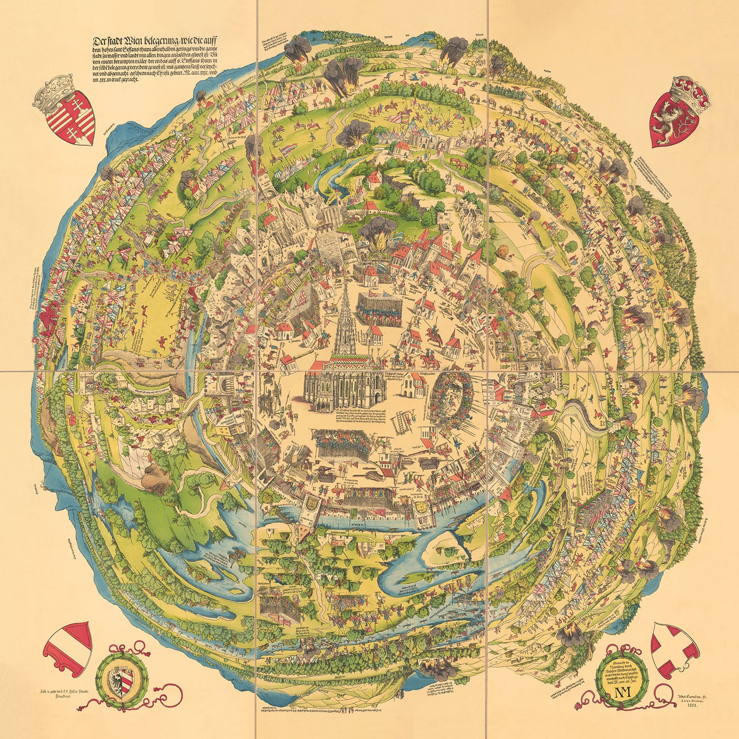
Step into the rich tapestry of history with Niklas Meldeman's masterful depiction of the First Turkish Siege of Vienna, a pivotal event in European history. Created in 1529 and published in Nuremberg in 1530, this circular panoramic map offers a unique and authentic representation of Vienna under siege. Meldeman's artistry prioritizes the significance of the depicted areas, providing a vivid and detailed illustration of the beleaguered city. At the heart of the map stands St. Stephen's Cathedral, symbolizing Vienna's resilience amidst the chaos.
The map's intricate design emphasizes Vienna's fortifications, showcasing the strategic importance of its defenses during the siege. The city walls are meticulously illustrated, with key points of attack highlighted, such as the Laklas Thurn set ablaze and the Kerner Thurn under cannon fire. The depiction of the breached wall to the right of Kerner Thurn adds to the dramatic narrative of the siege, offering a glimpse into the intense battles that took place.
Surrounding Vienna, the Turkish encampments are vividly portrayed, encircling the city and illustrating the scale of the Ottoman forces. The map captures the devastation wrought upon the suburbs, with numerous towns set ablaze by the attacking Turks. This visual representation of destruction underscores the dire circumstances faced by Vienna and its inhabitants during the siege, making the map not only a historical document but also a poignant piece of art.
Meldeman's map is further embellished with five coats of arms, adding a decorative and informative element to the piece. These heraldic symbols enhance the map's historical value, providing context and insight into the political landscape of the time. The detailed representation of the surrounding landscape, including the river flowing near the city, adds depth and dimension to the map, making it a comprehensive portrayal of the siege and its impact on Vienna.
This historically informative map is a testament to Meldeman's skill as a cartographer and his ability to capture the essence of a significant historical event. The First Turkish Siege of Vienna was a turning point in European history, and this map serves as a powerful reminder of the resilience and fortitude of the city's defenders. Whether you are a history enthusiast or a collector of fine maps, this exquisite piece offers a window into the past, bringing the drama and intensity of the siege to life.
Places on this map
- St. Stephen's Cathedral
- Laklas Thurn
- Kerner Thurn
- Vienna city walls
- Turkish encampments
- Suburbs of Vienna
- Various fortifications within Vienna
- River near Vienna
- Main fighting areas
- Surrounding landscape and hills
- Various buildings within Vienna
- Notable routes and paths into the city
- Key strategic points of the siege
- Locations of cannon fire and breaches
- Areas set ablaze during the siege
- Coats of arms embellishing the map
- Detailed representation of the outskirts of Vienna
- Important landmarks within the city
- Depiction of the main routes used by the attacking forces
- Various historical events illustrated within the city and its surroundings
Notable Features & Landmarks
- St. Stephen's Cathedral at the center
- Turkish encampments surrounding Vienna
- Laklas Thurn set ablaze
- Kerner Thurn under cannon fire
- Breached city wall to the right of Kerner Thurn
- Various buildings within Vienna minimized to emphasize fortifications
- Suburbs set ablaze by the attacking Turks
- Five coats of arms embellishing the map
- Depiction of the main fighting areas
- Numerous historical events illustrated within the image
- Circular panoramic view of Vienna
- Detailed representation of the city walls and fortifications
- Tents of the Turks on the outskirts of the town
- Visual representation of the destruction caused by the siege
- The river flowing near the city
- Various landmarks within Vienna
- Detailed depiction of the surrounding landscape
- Illustration of the attacking Turkish forces
- Representation of the main routes and paths into the city
- Visual emphasis on the strategic points of attack
- Artistic and thematic embellishments throughout the map
Historical and design context
- Name of the map: The First Turkish Siege of Vienna
- Creation Date: 1529
- Mapmaker/Publisher: Niklas Meldeman, published in Nuremberg in 1530
- Context about the mapmaker: Niklas Meldeman was a notable cartographer of his time, known for his detailed and thematic maps. His works often focused on significant historical events.
- Historical Significance:
- The map depicts the First Turkish Siege of Vienna in 1529, a pivotal event in European history where the Ottoman Empire attempted to capture Vienna.
- Meldeman's map is an authentic representation of the siege, illustrating various historical events that occurred during the conflict.
- Design and Style:
- The map is a circular panoramic plan, offering a rounded view of the area outside Vienna's city walls.
- It prioritizes the importance of represented areas rather than geographical accuracy.
- St. Stephen's Cathedral is centrally located, serving as a focal point.
- The map is embellished with five coats of arms, adding to its decorative and informative nature.
- Themes and Topics:
- Siege and Warfare: The map vividly depicts the Turkish siege, including the encampments, battles, and destruction.
- Fortifications: Emphasis on Vienna's fortifications, highlighting their strategic importance.
- Historical Events: Various key events during the siege are illustrated, such as the setting ablaze of Laklas Thurn and the cannon fire on Kerner Thurn.
- Countries and Regions Shown:
- The map focuses on Vienna, Austria, and the surrounding regions during the siege.
Please double check the images to make sure that a specific town or place is shown on this map. You can also get in touch and ask us to check the map for you.
This map looks great at every size, but I always recommend going for a larger size if you have space. That way you can easily make out all of the details.
This map looks amazing at sizes all the way up to 100in (250cm). If you are looking for a larger map, please get in touch.
The model in the listing images is holding the 16x16in (40x40cm) version of this map.
The fifth listing image shows an example of my map personalisation service.
If you’re looking for something slightly different, check out my collection of the best old maps to see if something else catches your eye.
Please contact me to check if a certain location, landmark or feature is shown on this map.
This would make a wonderful birthday, Christmas, Father's Day, work leaving, anniversary or housewarming gift for someone from the areas covered by this map.
This map is available as a giclée print on acid free archival matte paper, or you can buy it framed. The frame is a nice, simple black frame that suits most aesthetics. Please get in touch if you'd like a different frame colour or material. My frames are glazed with super-clear museum-grade acrylic (perspex/acrylite), which is significantly less reflective than glass, safer, and will always arrive in perfect condition.
This map is also available as a float framed canvas, sometimes known as a shadow gap framed canvas or canvas floater. The map is printed on artist's cotton canvas and then stretched over a handmade box frame. We then "float" the canvas inside a wooden frame, which is available in a range of colours (black, dark brown, oak, antique gold and white). This is a wonderful way to present a map without glazing in front. See some examples of float framed canvas maps and explore the differences between my different finishes.
For something truly unique, this map is also available in "Unique 3D", our trademarked process that dramatically transforms the map so that it has a wonderful sense of depth. We combine the original map with detailed topography and elevation data, so that mountains and the terrain really "pop". For more info and examples of 3D maps, check my Unique 3D page.
Many of our maps and art prints are chosen as thoughtful gifts for homes, offices, studies and meaningful places.
Choose a framed option for the easiest ready-to-hang gift, or choose an unframed print if the recipient may prefer to select their own frame.
We make orders locally in 23 countries around the world, so gifts can often be produced close to the recipient. This helps them arrive faster, travel more safely, and avoid customs or import duty surprises.
- We can deliver directly to the recipient
- Framed pieces arrive ready to hang
- Unframed prints are carefully packed in a strong protective tube
- Almost every order is made locally, for faster, safer gifting
- 90-day returns give the recipient time to decide
If you are not sure what to choose, please contact us. We can help you pick the right map, size, finish or delivery option.
Most orders are made locally and delivered in around 2–3 working days, depending on the product, size and destination.
We print and frame maps and artwork in 23 countries around the world, so your order is usually made close to you or your recipient. That means faster delivery, less time in transit, and no customs or import duty surprises.
Personalised and customised pieces usually take an extra 1–2 working days, because we prepare your design and send it to you for approval before printing.
Very large framed orders can take a little longer, as they need extra care in production and delivery.
Every order is carefully packaged: unframed prints are sent in a strong protective tube, while framed pieces are securely packed with protective materials around the frame.
If you need your order by a particular date, please contact us before ordering. We’ll check the best production route and delivery option for your location.
Express delivery is available at checkout for most countries. Next-day delivery is available in the UK, US, Singapore and the UAE.
Your order is covered by our 90-day returns policy and 10-year guarantee.
Our standard frame is a gallery-style black ash hardwood frame, with a simple, modern look. It is approximately 20mm (0.8in) wide. You can also view some lovely customer photos of framed maps and art.
We use super-clear acrylic glazing, also known as Perspex or Acrylite, instead of traditional glass. It is lighter, safer, and has lower reflectivity, giving the artwork a clearer, cleaner appearance.
Six standard frame colours are available at no extra cost: black, dark brown, dark grey, oak, white, and antique gold. Custom framing and mounting/matting is also available for customers looking for something more specific.
Most maps, art prints, and illustrations are also available as a framed canvas. We use matte cotton canvas, stretch it over a sustainably sourced wooden box frame, and then float the piece within a wooden outer frame. The finished result is beautifully presented, with no glazing between you and the artwork.
All frames are supplied ready to hang, with either string or brackets fitted to the back. Very large frames will include heavy-duty hanging plates and/or a mounting baton. If you have any questions, please get in touch.
We can also supply old maps and artwork on canvas, foam board, cotton rag, and other materials.
If you would prefer to frame your map or artwork yourself, please read our size guide before ordering.
My maps are extremely high quality reproductions of original maps.
I source original, rare maps from libraries, auction houses and private collections around the world, restore them at my London workshop, and then use specialist giclée inks and printers to create beautiful maps that look even better than the original.
My maps are printed on acid-free archival matte (not glossy) paper that feels very high quality and almost like card. In technical terms the paper weight/thickness is 10mil/200gsm. It's perfect for framing.
I print with Epson ultrachrome giclée UV fade resistant pigment inks - some of the best inks you can find.
I can also make maps on canvas, cotton rag and other exotic materials.
Learn more about The Unique Maps Co.
Map personalisation
If you're looking for the perfect anniversary or housewarming gift, I can personalise your map to make it truly unique. For example, I can add a short message, or highlight an important location, or add your family's coat of arms.
The options are almost infinite. Please see my map personalisation page for some wonderful examples of what's possible.
To order a personalised map, select "personalise your map" before adding it to your basket.
Get in touch if you're looking for more complex customisations and personalisations.
Map ageing
I have been asked hundreds of times over the years by customers if they could buy a map that looks even older.
Well, now you can, by selecting Aged before you add a map to your basket.
All the product photos you see on this page show the map in its Original form. This is what the map looks like today.
If you select Aged, I will age your map by hand, using a special and unique process developed through years of studying old maps, talking to researchers to understand the chemistry of aging paper, and of course... lots of practice!
If you're unsure, stick to the Original colour of the map. If you want something a bit darker and older looking, go for Aged.
If you are not happy with your order for any reason, contact me and I'll get it fixed ASAP, free of charge. Please see my returns and refund policy for more information.
I am very confident you will like your restored map or art print. I have been doing this since 1984. I'm a 5-star Etsy seller. I have sold tens of thousands of maps and art prints and have over 5,000 real 5-star reviews. My work has been featured in interior design magazines, on the BBC, and on the walls of dozens of 5-star hotels.
I use a unique process to restore maps and artwork that is massively time consuming and labour intensive. Hunting down the original maps and illustrations can take months. I use state of the art and eye-wateringly expensive technology to scan and restore them. As a result, I guarantee my maps and art prints are a cut above the rest. I stand by my products and will always make sure you're 100% happy with what you receive.
Almost all of my maps and art prints look amazing at large sizes (200cm, 6.5ft+) and I can frame and deliver them to you as well, via special oversized courier. Contact me to discuss your specific needs.
Or try searching for something!


