

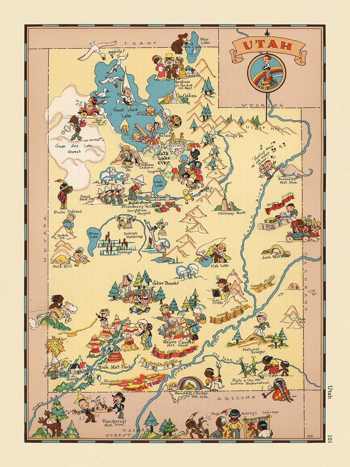


Pictorial Map of Utah by Ruth Taylor White, 1935: Salt Lake City, Zion, Arches, Great Salt Lake, Wasatch Mountains
20% off 2 — 33% off 3
Add any two eligible items to your bag to receive 20% off. Add a third and it will be complimentary (equivalent to 33% off when purchasing three).
No code needed — the offer applies automatically at checkout.
Valid on all standard maps and fine art prints. You can mix and match any designs.
If you’d like to ship items to multiple addresses, please contact us before placing your order.
Custom and bespoke commissions are excluded.
Contact us if you have any questions

Choose your size
Choose your finish


(More info)
Gift message & custom finish

If you want to add a gift message, or a finish (jigsaw, aluminium board, etc.) that is not available here, please request it in the "order note" when you check out.
Every order is custom made, so if you need the size adjusted slightly, or printed on an unusual material, just let us know. We've done thousands of custom orders over the years, so there's (almost) nothing we can't manage.
You can also contact us before you order, if you prefer!

- Made locally for fast, safe delivery
- No import duty or hidden fees
- Need advice? Message us on WhatsApp
Own a piece of history
7,000+ 5 star reviews


Step into the vibrant world of early 20th-century American cartography with “Utah..,” the original 1935 pictorial map by Ruth Taylor White. This captivating work is a standout from White’s celebrated cartoon atlas series, where each state is brought to life through a playful yet insightful lens. The map’s title, “Utah..,” hints at the mapmaker’s whimsical approach, inviting viewers to explore the state’s storied landscapes and cultural treasures. White’s distinctive style is immediately apparent: bold colors, exaggerated illustrations, and a keen eye for both geographic and cultural detail transform this map into a lively narrative of Utah’s identity during the 1930s.
Ruth Taylor White, a pioneering figure in American pictorial cartography, was renowned for her ability to blend artistry with geographic accuracy. Her maps are more than navigational tools—they are cultural artifacts that reflect the spirit of their era. White’s work is characterized by its engaging visual storytelling, where each illustration is carefully chosen to evoke the unique character of the region. In “Utah..,” she masterfully combines humor, historical context, and regional pride, making the map both an educational resource and a delightful conversation piece for collectors and enthusiasts alike.
The map’s design is a feast for the eyes, adorned with vibrant depictions of Utah’s most iconic natural wonders and landmarks. The Great Salt Lake commands attention, surrounded by the stark beauty of the Bonneville Salt Flats and the mysterious expanse of the Great Salt Lake Desert. National treasures such as Zion National Park, Bryce Canyon National Park, and Arches National Monument are beautifully illustrated, their distinctive geological formations rendered in White’s signature style. The Wasatch and Uinta Mountains rise majestically, while the Colorado and Green Rivers wind through the landscape, highlighting the state’s dramatic topography.
Beyond its natural features, “Utah..” offers a window into the economic and cultural life of the state during the 1930s. The map is dotted with charming vignettes representing local industries, folklore, and the daily lives of Utah’s residents. County boundaries are clearly delineated, providing a sense of order amid the artistic exuberance. The map’s playful approach does not detract from its informative value; rather, it enhances the viewer’s appreciation for Utah’s rich heritage and diverse landscapes, making it a superb addition to any collection of historical Americana.
Human settlements are thoughtfully represented, with Salt Lake City and other key towns such as Provo, Ogden, and St. George prominently featured. Each city and town is placed within its geographical context, reflecting both its historical significance and its enduring place in Utah’s story. Whether you are a seasoned collector, a lover of history, or an admirer of fine cartographic art, Ruth Taylor White’s “Utah..” is a testament to the enduring power of maps to inspire curiosity, celebrate place, and connect us to the past.
Cities and towns on this map
- Salt Lake City
- West Jordan
- Provo
- Orem
- Ogden
- St. George
- Layton
- Logan
- Murray
- Bountiful
- Tooele
- Cedar City
- Brigham City
- Price
- Richfield
- Moab
- Vernal
- Kanab
- Panguitch
- Fillmore
Notable Features & Landmarks
- Great Salt Lake is prominently illustrated and labeled
- Zion National Park is depicted and labeled
- Bryce Canyon National Park is depicted and labeled
- Arches National Monument is labeled (now Arches National Park)
- Natural Bridges National Monument is labeled
- Monument Valley is illustrated and labeled
- The Wasatch Mountains are illustrated
- The Colorado River is shown and labeled
- The Bonneville Salt Flats are depicted
- The Great Salt Lake Desert is illustrated
- The Sevier Desert is labeled
- The San Rafael Swell is illustrated
- The Uinta Mountains are depicted
- The Green River is labeled
- The Escalante Desert is labeled
Historical and design context
- Created by Ruth Taylor White in 1935, a pioneering figure in American pictorial cartography
- Features vibrant, colorful illustrations in a cartoonish, pictorial style, typical of White’s work in the 1930s
- Part of an entertaining and fanciful pictorial or cartoon atlas of the United States
- Illustrations depict stereotypical scenes and activities representative of Utah in the 1930s, reflecting the cultural and historical context of the era
- The map serves as a historical artifact, illustrating not only geography but also period-specific attitudes and artistic conventions
- Offers insight into how Utah and its people were perceived and represented in popular culture during the early 20th century
- Engaging visual narrative with playful, exaggerated imagery, designed to be both informative and entertaining
Please double check the images to make sure that a specific town or place is shown on this map. You can also get in touch and ask us to check the map for you.
This map looks great at every size, but I always recommend going for a larger size if you have space. That way you can easily make out all of the details.
This map looks amazing at sizes all the way up to 50in (125cm). If you are looking for a larger map, please get in touch.
The model in the listing images is holding the 18x24in (45x60cm) version of this map.
The fifth listing image shows an example of my map personalisation service.
If you’re looking for something slightly different, check out my collection of the best old maps to see if something else catches your eye.
Please contact me to check if a certain location, landmark or feature is shown on this map.
This would make a wonderful birthday, Christmas, Father's Day, work leaving, anniversary or housewarming gift for someone from the areas covered by this map.
This map is available as a giclée print on acid free archival matte paper, or you can buy it framed. The frame is a nice, simple black frame that suits most aesthetics. Please get in touch if you'd like a different frame colour or material. My frames are glazed with super-clear museum-grade acrylic (perspex/acrylite), which is significantly less reflective than glass, safer, and will always arrive in perfect condition.
This map is also available as a float framed canvas, sometimes known as a shadow gap framed canvas or canvas floater. The map is printed on artist's cotton canvas and then stretched over a handmade box frame. We then "float" the canvas inside a wooden frame, which is available in a range of colours (black, dark brown, oak, antique gold and white). This is a wonderful way to present a map without glazing in front. See some examples of float framed canvas maps and explore the differences between my different finishes.
For something truly unique, this map is also available in "Unique 3D", our trademarked process that dramatically transforms the map so that it has a wonderful sense of depth. We combine the original map with detailed topography and elevation data, so that mountains and the terrain really "pop". For more info and examples of 3D maps, check my Unique 3D page.
Many of our maps and art prints are chosen as thoughtful gifts for homes, offices, studies and meaningful places.
Choose a framed option for the easiest ready-to-hang gift, or choose an unframed print if the recipient may prefer to select their own frame.
We make orders locally in 23 countries around the world, so gifts can often be produced close to the recipient. This helps them arrive faster, travel more safely, and avoid customs or import duty surprises.
- We can deliver directly to the recipient
- Framed pieces arrive ready to hang
- Unframed prints are carefully packed in a strong protective tube
- Almost every order is made locally, for faster, safer gifting
- 90-day returns give the recipient time to decide
If you are not sure what to choose, please contact us. We can help you pick the right map, size, finish or delivery option.
Most orders are made locally and delivered in around 2–3 working days, depending on the product, size and destination.
We print and frame maps and artwork in 23 countries around the world, so your order is usually made close to you or your recipient. That means faster delivery, less time in transit, and no customs or import duty surprises.
Personalised and customised pieces usually take an extra 1–2 working days, because we prepare your design and send it to you for approval before printing.
Very large framed orders can take a little longer, as they need extra care in production and delivery.
Every order is carefully packaged: unframed prints are sent in a strong protective tube, while framed pieces are securely packed with protective materials around the frame.
If you need your order by a particular date, please contact us before ordering. We’ll check the best production route and delivery option for your location.
Express delivery is available at checkout for most countries. Next-day delivery is available in the UK, US, Singapore and the UAE.
Your order is covered by our 90-day returns policy and 10-year guarantee.
Our standard frame is a gallery-style black ash hardwood frame, with a simple, modern look. It is approximately 20mm (0.8in) wide. You can also view some lovely customer photos of framed maps and art.
We use super-clear acrylic glazing, also known as Perspex or Acrylite, instead of traditional glass. It is lighter, safer, and has lower reflectivity, giving the artwork a clearer, cleaner appearance.
Six standard frame colours are available at no extra cost: black, dark brown, dark grey, oak, white, and antique gold. Custom framing and mounting/matting is also available for customers looking for something more specific.
Most maps, art prints, and illustrations are also available as a framed canvas. We use matte cotton canvas, stretch it over a sustainably sourced wooden box frame, and then float the piece within a wooden outer frame. The finished result is beautifully presented, with no glazing between you and the artwork.
All frames are supplied ready to hang, with either string or brackets fitted to the back. Very large frames will include heavy-duty hanging plates and/or a mounting baton. If you have any questions, please get in touch.
We can also supply old maps and artwork on canvas, foam board, cotton rag, and other materials.
If you would prefer to frame your map or artwork yourself, please read our size guide before ordering.
My maps are extremely high quality reproductions of original maps.
I source original, rare maps from libraries, auction houses and private collections around the world, restore them at my London workshop, and then use specialist giclée inks and printers to create beautiful maps that look even better than the original.
My maps are printed on acid-free archival matte (not glossy) paper that feels very high quality and almost like card. In technical terms the paper weight/thickness is 10mil/200gsm. It's perfect for framing.
I print with Epson ultrachrome giclée UV fade resistant pigment inks - some of the best inks you can find.
I can also make maps on canvas, cotton rag and other exotic materials.
Learn more about The Unique Maps Co.
Map personalisation
If you're looking for the perfect anniversary or housewarming gift, I can personalise your map to make it truly unique. For example, I can add a short message, or highlight an important location, or add your family's coat of arms.
The options are almost infinite. Please see my map personalisation page for some wonderful examples of what's possible.
To order a personalised map, select "personalise your map" before adding it to your basket.
Get in touch if you're looking for more complex customisations and personalisations.
Map ageing
I have been asked hundreds of times over the years by customers if they could buy a map that looks even older.
Well, now you can, by selecting Aged before you add a map to your basket.
All the product photos you see on this page show the map in its Original form. This is what the map looks like today.
If you select Aged, I will age your map by hand, using a special and unique process developed through years of studying old maps, talking to researchers to understand the chemistry of aging paper, and of course... lots of practice!
If you're unsure, stick to the Original colour of the map. If you want something a bit darker and older looking, go for Aged.
If you are not happy with your order for any reason, contact me and I'll get it fixed ASAP, free of charge. Please see my returns and refund policy for more information.
I am very confident you will like your restored map or art print. I have been doing this since 1984. I'm a 5-star Etsy seller. I have sold tens of thousands of maps and art prints and have over 5,000 real 5-star reviews. My work has been featured in interior design magazines, on the BBC, and on the walls of dozens of 5-star hotels.
I use a unique process to restore maps and artwork that is massively time consuming and labour intensive. Hunting down the original maps and illustrations can take months. I use state of the art and eye-wateringly expensive technology to scan and restore them. As a result, I guarantee my maps and art prints are a cut above the rest. I stand by my products and will always make sure you're 100% happy with what you receive.
Almost all of my maps and art prints look amazing at large sizes (200cm, 6.5ft+) and I can frame and deliver them to you as well, via special oversized courier. Contact me to discuss your specific needs.
Or try searching for something!


